Showing 132 items matching " local government departments"
-
 Glen Eira Historical Society
Document - CAULFIELD RED CROSS UNIT
This file contains one item about this organisation: 1/Original copy of typewritten document titled ‘Forty Eighth Annual Report of the Caulfield ‘F’ Red Cross Unit from 01/07/1986 to 30/06/1987.’ This document includes details of members’ activities during the aforesaid year such as first aid training, fundraising, voluntary aid emergencies.caulfield, caulfield ‘f’ red cross unit, caulfield citizens’ advice bureau, caulfield welfare department, caulfield royal district nursing service, chisholm institute of technology, red cross, salvation army, caulfield council, caulfield hospital, caulfield racecourse, caulfield citizens’ red cross appeal committee, district citizens’ appeal committee of red cross, southern memorial hospital, elsternwick, mayor, mayoress, campbell jack cr. (mayor), campbell aj, anzac day, heart foundation, community services, voluntary workers, welfare establishments, accidents and disasters, emergency services, fundraising, charitable organisations, remembrance day, red cross calling, markets, disabled people, local government, blood bank, life line, telecross service, fires, central citizens’ appeal committee -
 Glen Eira Historical Society
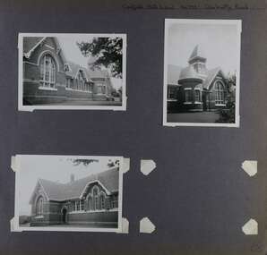
Album - Album page, Caulfield State School, No 773, Glen Huntly Road, Circa 1972
This photograph is part of the Caulfield Historical Album 1972. This album was created in approximately 1972 as part of a project by the Caulfield Historical Society to assist in identifying buildings worthy of preservation. The album is related to a Survey the Caulfield Historical Society developed in collaboration with the National Trust of Australia (Victoria) and Caulfield City Council to identify historic buildings within the City of Caulfield that warranted the protection of a National Trust Classification. Principal photographer thought to be Trevor Hart, member of Caulfield Historical Society. Most photographs were taken between 1966-1972 with a small number of photographs being older and from unknown sources. All photographs are black and white except where stated, with 386 photographs over 198 pages.From: Glen Eira Heritage Management Plan (1996) by Andrew Ward and Associates Caulfield State School No. 773 is important at the State level as the first of similar designs for small schools prepared by the Education Department under H.R. Bastow at Little Bendigo (1878), Glen Waverley (1880), Ascot (1882), Sandringham (1885) and Carlsrich (1892)·. It is a representative example of the Department's Gothic Revival designs, distinguished, however, by the semicircular treatment of the master's office, which compares with Portland (1879), Queensberry St Carlton (1880) and Footscray (1881). It has local significance as the earliest surviving Government School in Caulfield and as a centre for education from 1877, comparing with St. Mary's Jubilee School (qv) of 1887. The Caulfield State School of 1877, the horse tramway of 1889 and subsequently the electric trams were all events confirming the importance of Glenhuntly Road and the fledgling community of "Camden Town" wherein the City's commercial centre has its origins.Page 68 of Photograph Album with three exterior photographs (two portrait and one landscape) of one side of Caulfield State School with a fourth photo missing from the page.Hand written: Caulfield State School No. 773 Glenhuntly Road [top right] / 68 [bottom right] trevor hart, glen huntly road, caulfield state school, caulfield primary school, gothic revival, schools, caulfield south, arched window, tower, 1870's, camden town, red brick, curved windows, terracotta tiles, master's office, education, primary school, glenhuntly road, h r bastow -
 Flagstaff Hill Maritime Museum and Village
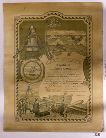
Award - Certificate of Service, F. W. Strahle, James Patten, 23-08-1907
This certificate acknowledges 21 years of service given by James Patten, one of the original 1859 Lifeboat Warrnambool as a boatman and bowman. At the time, all retiring Volunteer lifeboatmen were honoured with this award. It was made as a lithograph that was created by F. W. Strahle at the request of the Department of Lands & Survey, Melbourne, Victoria. During his time of service, James Patten was awarded a medal and certificate by the Royal Humane Society of Australasia for his bravery. Patten and his friend Joseph Lowe, who couldn't swim, were with their friend James Ferrier in a boat on the Hopkins River, Warrnambool, when their boat capsized. Ferrier made it to shore, and Patten tried unsuccessfully to hold onto Lowe and bring him to shore. The event occurred on 18th April 1890. The images on the Certificate show a collage of rescue events performed by the lifesavers; a shipwreck rescue in progress, lifeboat conveying five boatmen using two oars each, and a bowman standing at the bow, a linesman wearing a life jacket and holding a rescue line, a lifesaver ring with images of three sailing ships inside it, a shipwreck near shore, a woman and girl in shallow water, a rescue using a breeches buoy on the lifeline, two rescuers walking towards the survivor, rescue crew wearing waterproof clothing, a rocket machine with a pulley to bring the survivor in a breaches buoy to shore, and a rescue crew member holding a flare. Volunteers at the time received a small payment, or 'retainer'', for their practices and a payment of gratitude for the rescues they attended. Across the years between 1856 to 1979 the combined service in Victoria saved 260 lives. Amazingly, some of the volunteers could not even swim.This certificate shows the State and Local Government's appreciation for the years of service spent by in the endeavour to save lives in peril in and on the local waters in the early 20th Century. The lithographed design depicts the many skills and services performed by the lifesavers of the era.Certificate of Service, unframed, awarded to James Patten on 23rd August 1907, recognising his 21 years of service with the original Warrnambool Life Boat Service as a Boatman and Bowman. Certificate is on rectangular, cream paper, lithographed design, printed and handwritten. Letterhead with the Royal Coat of Arms of the United Kingdom and a French motto. Images depict lifesaving crew, lifeboat, rescue equipment and a rescue in progress. The border is waves inside of frame of looped rope. Signatures of Commissioner of Public Works, Secretary of Public Works, and Engineer in charge of Ports and Harbours, Melbourne. Printed from a lithograph produced by F.W. Strahle on 23rd June 1907.MOTTO: "Dieu Droit Et Mon, Ni Soit Qui Mal y" TREXT: "Certificate granted to James Patten as a mark of appreciation of his esteemed services of 21 years as Boatman and Bowman connected with the Departmental Life-Boat service at Warrnambool - dated the 23rd day of August 1907." SIGNATURES: [Commissioner of Public Works], [Secretary of Public Works], [Engineer in charge of Ports and Harbours Melbourne] "Lithographed at the Dept of Lands & Survey - Melb/ by F.W. Strahle, 23.6.07"flagstaff hill, warrnambool, flagstaff-hill, maritime museum, maritime village, shipwreck-coast, flagstaff hill maritime museum & village, james patten, life-saving, lifesaving, rescue, bravery, drowning, joseph lowe, james ferrier, hopkins river, boat accident, certificate of service, 1890, 1907, bowman, boatman, departmental life-boat service, life-boat service, lifeboat service, august 1907, commissioner of public works, public works, ports and harbours melbourne, lands & survey melbourne, f w strahle, lithograph, 1856-1979, 260 lives saved, victorian volunteers, lifeboatmen, retired lifeboatmen -
 Flagstaff Hill Maritime Museum and Village
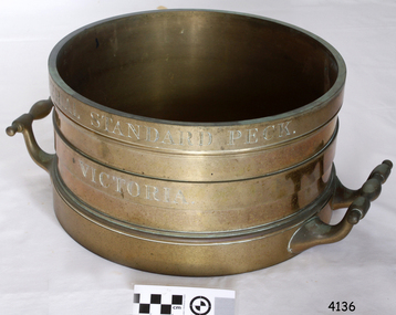
Equipment - Standard measure, Mid to late 19th Century
The beginning of standardised weights and measures began In Victoria when the Melbourne Observatory received sets of standard weights and measures, which had been tested in Britain against the then British Imperial standards. These included the primary standard yard and pound for the Colony of Victoria. Other standards of weights and measure held by shires and the administrative body's within the colony could then be compared to these primary standards. A Weights and Measures Act was passed in Victoria in 1862, establishing local inspectors throughout the colony. By the 1870s each local council and shire in Victoria held a set of standards that were used to test scales, weights and dry measures used by wholesalers, factories and shops. Every ten years the councils’ standards would themselves need to be rechecked against the Victorian Standards. The checking was done by the Victorian Customs Department in the 19th century, but with the transfer of responsibility for customs to the Federal Government in 1901, weights and measures function was retained by the Victorian Government and was shifted to the Melbourne Observatory. In 1904, a new building was erected at the south end of the Great Melbourne Telescope House, where the standard weights and measures and testing equipment was installed. This room had a large whirling apparatus for testing air meters and became known as the Whirling Room. When the Melbourne Observatory closed in 1944, the Weights and Measures Branch was formed to continue and this branch remained at the Observatory site unit until 1995. J & M Ewan History: J&M Ewan was a Melbourne firm that began by selling retail furniture and wholesale ironmongery. They had substantial warehouses situated at the intersection of 81-83 Elizabeth and Little Collins Streets, the business was established by James M Ewan in 1852. Shortly afterwards he went into partnership with William Kerr Thomson and Samuel Renwick. When Ewan died in 1868 his partners carried on and expanded the business under his name J & M Ewan. The business was expanded to provide a retail shop, counting-house and private offices. Wholesale warehouses adjoined these premises at 4, 6 and 10 Little Collins Street, West. This company provided and sold a large and varied amount of imported goods into the colony that consisted of agriculture equipment, building materials, mining items as well as steam engines, tools of all types and marble fireplaces. They also supplied the Bronze measuring containers in the Flagstaff Hill collection and the probability is that these containers were obtained by the local Melbourne authority that monitored weights and measures in the mid to late 19th century. The company grew to employ over 150 people in Melbourne and opened offices at 27 Lombard St London as well as in New Zealand and Fiji. The company also serviced the Mauritius islands and the pacific area with their steamship the Suva and a brig the Shannon. Robert Bate History: Robert Brettell Bate (1782-1847) was born in Stourbridge, England, one of four sons of Overs Bate, a mercer (a dealer in textile fabrics, especially silks, velvet's, and other fine materials)and banker. Bate moved to London, and in 1813 was noticed for his scientific instrument making ability through the authority of the “Clockmakers Company”. Sometime in the year 1813 it was discovered that one Robert Brettell Bate, regarded as a foreigner in London had opened a premises in the Poultry selling area of London. He was a Mathematical Instrument maker selling sundials and other various instruments of the clock making. In 1824, Bate, in preparation for his work on standards and weights, leased larger premises at 20 and 21 Poultry, London, at a rental of four hundred pounds per annum. It was there that Bate produced quality metrological instruments, which afforded him the recognition as one of one of the finest and principal English metrological instrument-makers of the nineteenth century. English standards at this time were generally in a muddle, with local standards varying from shire to shire. On 17 June 1824, an Act of Parliament was passed making a universal range of weights, measures, and lengths for the United Kingdom, and Bate was given the job of crafting many of the metrological artifacts. He was under instruction from the renown physicist Henry Kater F.R.S. (1777-1835) to make standards and to have them deposited in the principal cities throughout the United Kingdom and colonies. Bate experimented with tin-copper alloys to find the best combination for these items and by October 1824, he had provided Kater with prototypes to test troy and avoirdupois pounds, and samples with which to divide the troy into grams. Bate also cast the standard for the bushel, and by February 1825, had provided all the standards required of him by the Exchequer, Guildhalls of Edinburgh, and Dublin. In 1824, he also made a troy pound standard weight for the United States, which was certified for its accuracy by Kater and deposited with the US Mint in 1827. Kater, in his address to the Royal Society of London, acknowledged Bate's outstanding experimentation and craftsmanship in producing standards of weights, measures, and lengths. An example of a dry Bronze measuring container made specifically for J & M Ewan by possibly the most important makers of measurement artifacts that gives us today a snapshot of how imperial weights and measures were used and how a standard of measurement for merchants was developed in the Australian colonies based on the Imperial British measurement system. The container has social significance as an item retailed by J & M Ewan and used in Victoria by the authorities who were given legal responsibility to ensure that wholesalers and retailers of dry goods sold in Victoria were correct. The container was a legal standard measure so was also used to test merchants containers to ensure that their distribution of dry goods to a customer was correct. Bronze round container with brass two handles used as a legal standard for measuring dry quantities & is a 'peck' measurement. "IMPERIAL STANDARD PECK" engraved around top of container with " VICTORIA" engraved under.flagstaff hill, warrnambool, shipwrecked-coast, flagstaff-hill, flagstaff-hill-maritime-museum, maritime-museum, shipwreck-coast, flagstaff-hill-maritime-village, standard measure, bronze, peck measurement, j & m ewan, victorian standard dry measurement, bronze container, victorian standards, melbourne observatory, robert bettell bate -
 Flagstaff Hill Maritime Museum and Village
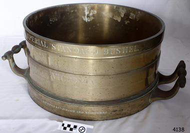
Equipment - Standard measure, Mid to Late 19th Century
The beginning of standardised weights and measures began In Victoria when the Melbourne Observatory received sets of standard weights and measures, which had been tested in Britain against the then British Imperial standards. These included the primary standard yard and pound for the Colony of Victoria. Other standards of weights and measure held by shires and the administrative body's within the colony could then be compared to these primary standards. A Weights and Measures Act was passed in Victoria in 1862, establishing local inspectors throughout the colony. By the 1870s each local council and shire in Victoria held a set of standards that were used to test scales, weights and dry measures used by wholesalers, factories and shops. Every ten years the councils’ standards would themselves need to be rechecked against the Victorian Standards. The checking was done by the Victorian Customs Department in the 19th century, but with the transfer of responsibility for customs to the Federal Government in 1901, weights and measures function was retained by the Victorian Government and was shifted to the Melbourne Observatory. In 1904, a new building was erected at the south end of the Great Melbourne Telescope House, where the standard weights and measures and testing equipment was installed. This room had a large whirling apparatus for testing air meters and became known as the Whirling Room. When the Melbourne Observatory closed in 1944, the Weights and Measures Branch was formed to continue and this branch remained at the Observatory site unit until 1995. J & M Ewan History: J&M Ewan was a Melbourne firm that began by selling retail furniture and wholesale ironmongery. They had substantial warehouses situated at the intersection of 81-83 Elizabeth and Little Collins Streets, the business was established by James M Ewan in 1852. Shortly afterwards he went into partnership with William Kerr Thomson and Samuel Renwick. When Ewan died in 1868 his partners carried on and expanded the business under his name J & M Ewan. The business was expanded to provide a retail shop, counting-house and private offices. Wholesale warehouses adjoined these premises at 4, 6 and 10 Little Collins Street, West. This company provided and sold a large and varied amount of imported goods into the colony that consisted of agriculture equipment, building materials, mining items as well as steam engines, tools of all types and marble fireplaces. They also supplied the Bronze measuring containers in the Flagstaff Hill collection and the probability is that these containers were obtained by the local Melbourne authority that monitored weights and measures in the mid to late 19th century. The company grew to employ over 150 people in Melbourne and opened offices at 27 Lombard St London as well as in New Zealand and Fiji. The company also serviced the Mauritius islands and the pacific area with their steamship the Suva and a brig the Shannon. Robert Bate History: Robert Brettell Bate (1782-1847) was born in Stourbridge, England, one of four sons of Overs Bate, a mercer (a dealer in textile fabrics, especially silks, velvet's, and other fine materials)and banker. Bate moved to London, and in 1813 was noticed for his scientific instrument making ability through the authority of the “Clockmakers Company”. Sometime in the year 1813 it was discovered that one Robert Brettell Bate, regarded as a foreigner in London had opened a premises in the Poultry selling area of London. He was a Mathematical Instrument maker selling sundials and other various instruments of the clock making. In 1824, Bate, in preparation for his work on standards and weights, leased larger premises at 20 and 21 Poultry, London, at a rental of four hundred pounds per annum. It was there that Bate produced quality metrological instruments, which afforded him the recognition as one of one of the finest and principal English metrological instrument-makers of the nineteenth century. English standards at this time were generally in a muddle, with local standards varying from shire to shire. On 17 June 1824, an Act of Parliament was passed making a universal range of weights, measures, and lengths for the United Kingdom, and Bate was given the job of crafting many of the metrological artifacts. He was under instruction from the renown physicist Henry Kater F.R.S. (1777-1835) to make standards and to have them deposited in the principal cities throughout the United Kingdom and colonies. Bate experimented with tin-copper alloys to find the best combination for these items and by October 1824, he had provided Kater with prototypes to test troy and avoirdupois pounds, and samples with which to divide the troy into grams. Bate also cast the standard for the bushel, and by February 1825, had provided all the standards required of him by the Exchequer, Guildhalls of Edinburgh, and Dublin. In 1824, he also made a troy pound standard weight for the United States, which was certified for its accuracy by Kater and deposited with the US Mint in 1827. Kater, in his address to the Royal Society of London, acknowledged Bate's outstanding experimentation and craftsmanship in producing standards of weights, measures, and lengths. An example of a dry Bronze measuring container made specifically for J & M Ewan by possibly the most important makers of measurement artefacts that gives us today a snapshot of how imperial weights and measures were used and how a standard of measurement for merchants was developed in the Australian colonies based on the Imperial British measurement system. The container has social significance as an item retailed by J & M Ewan and used in Victoria by the authorities who were given legal responsibility to ensure that wholesalers and retailers of dry goods sold in Victoria were correct. The container was a legal standard measure so was also used to test merchants containers to ensure that their distribution of dry goods to a customer was correct.Maker Possibly Robert Brettell Blake or De Grave, Short & Co Ltd both of LondonContainer brass round for measuring quantities- Has brass handles & is a 'Bushel' measurement. 'Imperial Standard Bushel Victoria' engraved around container. Container bronze round shape for measuring dry quantities has brass handles & is a 'Bushel' measurement"IMPERIAL STANDARD BUSHEL" engraved around the top of the container. VICTORIA engraved under "J & M Ewan & Co London and Melbourne" engraved around the bottom of the container.flagstaff hill, warrnambool, shipwrecked-coast, flagstaff-hill, flagstaff-hill-maritime-museum, maritime-museum, shipwreck-coast, flagstaff-hill-maritime-village, standard measure, bushel, bushel measurement, j & m ewan, dry measurement, victorian measurement standard, bronze container, melbourne observatory, robert brettell bate -
 City of Moorabbin Historical Society (Operating the Box Cottage Museum)
Photograph - Map of Dendy's Special Survey, 1852 Map of Henry Dendy's Special Survey of 1841, 19th Century
A Map drawn in 1852 that shows the 5,120 acres that formed Dendy's Special Survey of 1841. In 1840 Henry Dendy, a farmer in Surrey, England acquired a "Special Survey" from the Commissioners for Land and Emigration which gave Dendy the right to choose land in Port Phillip for the "bargain basement" price of only £1 per acre for 5120 acres, (an area of 8 square miles). The Special Survey also included the right to "the shipment of a worker for every £20 spent on land, whose free passage was paid by the Crown, equalling a total of 100 workers ". Accordingly Dendy sold his English holdings and paid the required £5120 and arrived in Melbourne in February 1841. However by this time land in the new colony was selling for £5 - £40 per acre. Because Henry Dendy possessed the order from the Colonial Office in London he was able to successfully oppose Governor LaTrobe's attempts to alter the price of the land. Dendy appointed Jonathan Were, (an entrepreneur, who had arrived in 1839), as his Manager and who later became a partner. Together, Dendy and Were decided on an area 5 miles south from Melbourne, bounded by North Road, East Boundary Road, South Road and to the west by Port Phillip Bay. Were and Dendy pitched their tents in the area now known as ' Park St, Brighton' and sank a well near the corner of 'St Andrew's St and Wells St'. By 1845 J.B Were and Company had bought almost half of Dendy's land and Were built himself "Moorabbin House" in Were St Brighton made from stone, quarried from local cliffs. It was still standing in 1924. Legend records Moorabbin is named after the Aboriginal word for ' Mother's Milk ' The soil is very fertile and well supplied with water especially in the area called 'East Brighton' - now known as Bentleigh and East Bentleigh - By 1850 the area had developed with numerous market gardens, dairy farms, fruit gardens and vineyards supplying food for the growing population of Melbourne.This Map shows the birth of the Brighton and Moorabbin area. On 18th January1859 Brighton was proclaimed a Municipality and a Borough by October 1863. Meanwhile, following a Petition, the area of East and South Brighton, incorporating Mordialloc, Cheltenham, Mentone, Sandringham and Oakleigh separated from Brighton to form the Moorabbin District Roads Board becoming the first Local Government Authority. Col. William Mair was elected as the first Chairman of the Moorabbin Roads Board. Moorabbin Shire 1871 developed further and was declared a City in1934. The City of Moorabbin was the largest Municipality in Melbourne before the Amalgamation of Councils in 1994 when it was divided in the south to City of Kingston and in the north to City of Glen Eira A Photo-lithographed 1852 Map showing the 5,120 acres that formed Dendy's Special Survey of 1841. Henry Dendy & Jonathan Were chose an area 5 miles south from Melbourne, bounded by North Road, East Boundary Road, South Road and to the west by Port Phillip Bay. Moorabbin County of Bourke / Photo-Lithographed at the department of Lands and Survey. /Melbourne. / Price 1/- brighton, moorabbin, bentleigh, cheltenham, dendy henry, bent thomas, were jonathan, special survey -
 Bendigo Historical Society Inc.
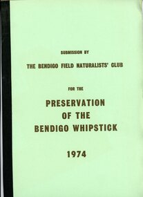
Document - PETER ELLIS COLLECTION: SUBMISSION BY THE BENDIGO FIELD NATURALIST CLUB FOR THE PRESERVATION OF THE WHIPSTICK 1974, 1974
PETER ELLIS COLLECTION: SUBMISSION BY THE BENDIGO FIELD NATURALIST CLUB FOR THE PRESERVATION OF THE WHIPSTICK 1974 The submission was sent to: the Minister for Local Government and the Town and Country Planning Board The Minisry for Conservation and its agency, the Forests Commission and Lands Department Federal Government Ministeries for Environment, Concervastion and Science, and the National Estate. Opening Paragraphs: This re-submission was compiled to bring to the attention of the authorities many aspects relating to the preservation of the Bendigo Whipstick which were not so apparent at the time of the earlier submission. In fact the 19721 submissions was mainly aimed at having reserved forest (which lie a opposite extremities to the Whipstick scrub) declared Forest Park. It is the central belt of Whipstick scrub that is of scientific interest and considered unipue and which we were primarily concerned in preserving and retaining as one viable ecological unit. The Submission consists of: INTRODUCTION Opening Explanation Whipstick Eucalyptus Cutting for Oil Distallation (Photographs) Agricultural Intrusions into the Whipstick (Photographs) CONTENTS Illustrations The Significance of the Bendigo Whipstick Diary of Whipstick Conservation Events Socialogical Implications Conservation policies and reccomendations Agricultural Aspects Eucalyptus Oil Situation Alternatives for the Eucalyptus Oil Industry Future Conservation of the Whipstick Reccomendation for Acquisition Programperson, individual, peter ellis oam -
Port Melbourne Historical & Preservation Society
Book - Notebook, Port Melbourne Electricity Supply Department, Electricity Supply Department, Port Melbourne Council, 1914
Black notebook, badly scuffed: Port Melbourne Electricity Supply Department, half filled with handwritten reports addressed to the Town Clerks (HEATH, ANDERSON) by F.E. WINWOOD (1914-16) and Norman D. MacPHEE (1916-21). Also notations on various aspects of operation and installations to local premises.local government, norman d macphee, frank e winwood -
Port Melbourne Historical & Preservation Society
Book - Port Melbourne Council records, Engineering Department, Town of Port Melbourne?, Stone Breakers, 1894 - 1909
One of two Port Melbourne municipal record books giving details of stone metal contracts and measurements 1909-1924 in columns headed dept/Breaker's name/Sub account/Dat/Balance after deducting sub. A remarks column sometimes shows where stone was used. Title 'Measurement Book' is on spine. The pages in Vol. 1 are printed at the top 'Town of Port Melbourne - Account of Metal Measurements"Label 'Stone Breakers' on front coverengineering - roads streets lanes and footpaths, local government - town of port melbourne -
Port Melbourne Historical & Preservation Society
Book - Port Melbourne Council records, Engineering Department, Town of Port Melbourne?, Measurement Book, 1909 - 1924
One of two Port Melbourne municipal record books giving details of stone metal contracts and measurements 1909-1924 in columns headed dept/Breaker's name/Sub account/Dat/Balance after deducting sub. A remarks column sometimes shows where stone was used. Title 'Measurement Book' is on spine.Title 'Measurement Book' is on spine.engineering - roads streets lanes and footpaths, local government - town of port melbourne, local government - city of port melbourne -
Port Melbourne Historical & Preservation Society
Document - Sale Notices, Relating to properties in Port Melbourne, "Sale Notices", 1960 - 1979
Index of each volume was carried out by Margaret Bride 2013 and Jack Bolt 2017/18.29 thick volumes of letters, forms, memoranda, etc. sent to the Building and Rates Departments of the former City of Port Melbourne by property owners, law firms and others. The items concern matters relating to properties and mostly are part of the process of putting a property up for sale. Those realting to a particular property are generally grouped together and are usually arranged in alphabetical order of streets. The volumes extend from early 1960s to late 1979. They have card front and back covers, metal holders and taped spines . (.01) prior to 30.09 1962 (.02) 1.10.1962 to 30.09.1963 (.03) 1963/64 (.04) 01.10.1964 to 30.09.1965 ; A-F (.05) 01.10.1964 to 30.09.1965 ; G-Z (.06) 01.10.1965 to 30.09.1966 (.07) 1966 to 1967 (.08) 01.10.1967 to 30.09.1968 (.09) 1968 to 1969, A-G (.10) 1968 to 1969, H-Z (.11) 01.10.1969 to 30.09.1970, A-K (.12) 01.10.1969 to 30.09.1970, L-Z (.13) 01.10.1970 to 30.09.1971, A-L (.14) 01.10.1970 to 30.09.1971, M-Z (.15) 01.10.1972 to 30.09.1973, A-H (.16) 01.10.1972 to 30.09.1973, I-Z (.17) 01.10.1973 to 30.09.1974, A-Glocal government - city of port melbourne, built environment - domestic -
Port Melbourne Historical & Preservation Society
Book - Borough of Sandridge, Public Works Committee May 1862 to March 1864, 1862 - 1864
Minutes of the Borough of Sandridge Public Works Committee 1862 - 64. Similar in appearance to other Sandridge committee minutes, but much larger.local government - borough of sandridge, engineering department - borough of sandridge -
Port Melbourne Historical & Preservation Society
Plan - Sandridge, Department of Lands and Survey, "The Township of Sandridge", 5 Nov 1860
Map of Sandridge, lithographed 1860, showing subdivisions on Evans Street, but no other development West of the railway Lihographed at the Department of lands and Survey, Melbourne 5th November 1860. Hand drawn annotations added at unknown date.Hand written "clay ground" 18 chains long, 7.5 chains broad, 26 chains from railwayengineering - roads streets lanes and footpaths, sandridge lagoon, transport - railways, town planning, local government - borough of sandridge -
Port Melbourne Historical & Preservation Society
Article - Newspaper clipping, Meeting, Sandridge Borough Council, "EPA Work", 5 Mar 1878
Report (photocopy) on Sandridge Borough Council meeting on Tuesday, March 5th 1878, in the Record, March 8th 1878. Highlighted is reference to the making of a footpath on Ross St, of interest to ratepayers, in particular a Mr Kennett (perhaps Caleb?)local government - borough of sandridge, engineering department - borough of sandridge, engineering - roads streets lanes and footpaths, caleb (?) kennett, borough of sandridge -
Port Melbourne Historical & Preservation Society
Plan - Bus Shelter, Lorimer Street, Fishermans Bend, Engineering Department, City of Port Melbourne: A N B, 23 Mar 1942
Working drawings for the construction of bus shelter in Lorimer Street, Fishermens Bend, 1942. Preliminary design only. Subtitled "Design B" "Design A"Signed: Approved " ":Drawn: A. N. B.transport - bus, built environment - civic, fishermans bend, local government - city of port melbourne -
Port Melbourne Historical & Preservation Society
Plan - Bus Shelter, Lorimer Street, Fishermans Bend, Engineering Department, City of Port Melbourne: A N B, 25 Mar 1914
Working drawings for the construction of bus shelter in Lorimer Street, Fishermens Bend 1942. Preliminary design only. Subtitled "Design D" and "Design E".Signed: Approved " " Drawn: A. N. B.transport - bus, built environment - civic, fishermans bend, local government - city of port melbourne -
Port Melbourne Historical & Preservation Society
Equipment - City of Port Melbourne, Dog tag dispenser, 1993
Metal dispenser containing dog tags to be issued from the City of Port Melbourne Dog Licensing Department, 1994/95local government - city of port melbourne -
Port Melbourne Historical & Preservation Society
Sign - ABG Departmental Safety Policy
Wood-framed memo to engineering personnel regarding safety policy while working in the department. A.B.G. Departmental Safety Policy. Wooden frame removed 01.10.2013local government, engineering, health - accidents and injury -
Port Melbourne Historical & Preservation Society
Tool - Ruler, City of Port Melbourne Electricity Supply Department, 1994
(1) white & (1) pink 12" (30cm) plastic rulers promoting the City of Port Melbourne Electricity Supply Departmentlocal government - city of port melbourne, liana thompson, mayors -
Port Melbourne Historical & Preservation Society
Plan - Proposed tramway for Williamstown Road, Port Melbourne, 5 May 1887
Detailed drawings of improved steel tramway broad plate system for ordinary road, proposed for Williamstown Road 1887local government - borough of port melbourne, engineering department - borough of port melbourne -
Port Melbourne Historical & Preservation Society
Document, Jacobs, Lewis, Vines, Architects and Conservation Planners, Port Melbourne Conservation study, Jul 1979
Part of research material for Çompeting ideas for the Inner City 1925-1985 (January 1991). See 1543'Port Melbourne Conservation Study' commissioned by the Port Melbourne City Council and the Australian Heritage Commission, July 1979, 226 pagesÇity of Port Melbourne, City Engineer's Department'built environment, local government - city of port melbourne, town planning, heritage, australian heritage commission -
Port Melbourne Historical & Preservation Society
Tool - Ruler, City of Port Melbourne Electricity Supply Department, 1990
These rulers were handed out at festivals and citizenship ceremoniesOrange plastic ruler promoting the City of Port Melbourne Electric Supply Department c1990local government - city of port melbourne, utilities - electricity -
 Port Melbourne Historical & Preservation Society
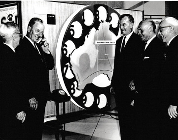
Photograph - City of Port Melbourne Councillors & Town Clerk at a PMG presentation of Subscriber Trunk Dialing (STD), C. 1960s
City of Port Melbourne Councillors, Town Clerk and Electrical Engineer at a PMG presentation of the new concept of Subscriber Trunk Dialling. (STD). L - R Cr Les TURNER, Cr Ray JULIER, Jack ANDERSON (Electrical Engineer), Cr Cyril LETTS, Andy AANENSEN (Town Clerk). Probably taken in the mid to late 1960s. Andy Aanensen was Town Clerk 1959-1968 and Cyril Letts served on Council 15 May 1954 until he resigned on 24 Sep 1968.B & W photograph of City of Port Melbourne Councillors & staff. Behind the group is map of Australia inside the dial of a telephone labelled Subscriber Trunk Dialing.Names on the reverse of photo are listed right to left.engineering department - city of port melbourne, leslie stanley turner, ray julier, cyril letts, andreas (andy) t aanensen, local government - city of port melbourne, jack anderson -
Port Melbourne Historical & Preservation Society
Functional object - City of Port Melbourne Engineering Department stamp, c.1970
Stamp used for franking postage for the Engineering Department of the City of Port Melbourne.Grey handled stamp for use with a stamp pad. local government - city of port melbourne, engineering department - city of port melbourne -
Port Melbourne Historical & Preservation Society
Letter - re Site of Sandridge Municipal Council Chambers, 5 Oct 1860
Handwritten letter advising of the proclamation of the site for Municipal Council Chambers at Sandridge 5th October 1860local government - municipal district of sandridge, built environment - zoning, department of lands and survey, clement hodgkinson -
Port Melbourne Historical & Preservation Society
Letter - Department of Lands and Survey granting land for temporary reserve, 18 Mar 1860
Handwritten letter from Dept of Lands and Survey granting Crown land for temporary reserve as site for abattoirs 18 March 1861local government - borough of sandridge, industry - noxious, department of lands and surveys, clement hodgkinson -
Port Melbourne Historical & Preservation Society
Letter - Department of Lands and Survey grant for improving public parks in Sandridge, Department of Lands and Survey, 19 Oct 1863
Handwritten letter from Dept of Lands and Survey 19.10.1863, notifying grant of £90/0/0 for the improving of public parks in Sandridge for 1863local government - borough of sandridge -
Port Melbourne Historical & Preservation Society
Letter - Department of Lands and Survey reply re setting out Sandridge streets, Department of Lands and Survey, 30 Jan 1861
Handwritten letter on blue foolscap laid paper, from Dept of Lands and Survey 13.1.1861 replying to Town Clerk's request on setting out Sandridge streetslocal government - borough of sandridge -
Port Melbourne Historical & Preservation Society
Letter - Department of Lands and Survey re notification of crown grants for Sandridge municipal chambers and market site, Department of Lands and Survey, 20 Jun 1862
Handwritten letter on blue foolscap laid paper, from Dept of Lands and Survey 20.6.1862 notifying Town Clerk of two crown grants, for municpal chambers and for market site. Paper watermarked A.Cowan & Sons 1855Notations in pencil on back, upper leftlocal government - borough of sandridge, market reserve, port melbourne town hall -
Port Melbourne Historical & Preservation Society
Letter - Department of Lands and Survey re proclaimation of Beach Street, Sandridge, Department of Lands and Survey, 16 Mar 1861
Handwritten letter on blue foolscap laid paper, from Dept of Lands and Survey 16.3.1861, directing attention to proclamation in Government Gazette re Beech Street (sic) Sandridgelocal government - borough of sandridge, engineering - roads streets lanes and footpaths