Showing 1317 items
matching making road
-
 Ringwood and District Historical Society
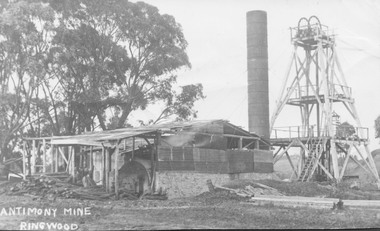
Photograph, Antimony Mine, Ringwood 1920
... in making roads in Ringwood in early days."...") around place used extensively in making roads in Ringwood ...Black and white photograph showing mine building and poppet head. Gum trees to left of picture. (3 copies, various sizes)Typed below photograph, "Antimony Mine, Ringwood - 1920". Catalogue card reads, "Main antimony mine, 1920. Now Civic Centre site. Mullock heaps ("tailings") around place used extensively in making roads in Ringwood in early days." -
 The Beechworth Burke Museum
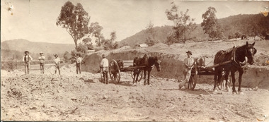
Photograph, Late 1800s
... Beechworth Road Making... and Cart Beechworth Road Making Beechworth Council Roads Road ...This photograph depicts six men and two horses with carts in the process of constructing a road. The men each stand in a relatively relaxed position, posing for the camera. However, the amount of upturned soil surrounding them suggests the hard work they have endured, armed only with pitchforks and shovels. The creation of new roads in the Beechworth area had become a priority for the Beechworth council in the second half of the nineteenth century. This included connecting roads which radiated out of Beechworth to surrounding towns. This led to the expansion of the local government authority over the surrounding countryside, greatly strengthening Beechworth's central position. The use of horse and cart to take away the removed soil, as well as the style of the men's attire, suggests that this photograph dates back to the late 1800s. It can also be assumed that this photograph was taken somewhere in the surrounding hills of Beechworth. This photograph is historically significant as it provides insight into the rapid expansion of roads in and around Beechworth during the second half of the nineteenth century. Sepia rectangular photograph on matte photographic paper mounted on card Reverse: BMM 2982 / road construction, beechworth roads, 1800s, 1800s beechworth, beechworth hills, horse and cart, beechworth road making, beechworth council roads, road expansion, beechworth surrounding hills -
 Kiewa Valley Historical Society
Postcard Circa 1950, Road to Bogong High Plains Kiewa Hydro Electric Project, Circa 1950's
... Road making... at Landford's Gap. SECV Road making Victorian Alps In white lettering ...This postcard was produced in the 1950's for the tourist trade in the Kiewa Valley and Alpine region. It encompasses the period when the State of Victoria was pressured by the ever increasing demand by industry and its population for electricity supplies. Hydro electricity was seen as an untapped natural resource to quench this demand. The Victorian Alps and the rivers flowing into its valleys was ideal for the construction of the Kiewa Hydro Electricity Scheme. The late 1940's saw the development of this scheme and the changing of sections of alpine landscape is covered by this and other postcards/pictures (tourists, construction workers, and established rural populations). This period in time was before the established wildlife and forest/nature groups became political activist who changed legislative acts to protect the environment.This rural region (Kiewa Valley/alpine plains) was at most only significant to a smaller group of winter sports, summer hikers/horse riders and rural farmers/graziers. The numbers of tourists and the increase in the local resident population was boosted by the construction of the Hydro Electricity Scheme. This influx to the regional population resulted in a corresponding diversity in services and brought about an environment that responded to a growing level of tourists and thereby permitting this industry to grow more rapidly than it would have naturally. This postcard details an attraction to the "cleaner" method of providing electricity. This postcard was purchased in 1950 by a surveyor at Landford's Gap.This black and white photograph on a Valentine's postcard is from a V2 Argus photograph.. It is on a 200g/m paper density photo side gloss. See 0480 (A) - (G) for other photos of similar postcards.In white lettering " ROAD TO BOGONG HIGH PLAINS KIEWA HYDRO-ELECTRIC PROJECT", V3secv, road making, victorian alps -
 Greensborough Historical Society
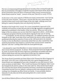
Folder, Hume Street Improvement Committee, 1958_
... road making... feel of the area. greensborough road making brian roberts hume ...The Hume Street Improvement Committee was one of several 'progress associations' in the Greensborough area at the time the area was being urbanised. A typed page explains the concerns of residents when the street was being paved. Includes photographs and maps of area.These documents are concerned with the urbanisation of Greensborough in the mid 20th century while residents tried to maintain the rural feel of the area.Foolscap manilla folder containing various lists, maps and photographs.On cover "Hume Street Improvement Committee/ spare circulars/maps"greensborough, road making, brian roberts, hume street improvement committee, briar hill -
 Whitehorse Historical Society Inc.
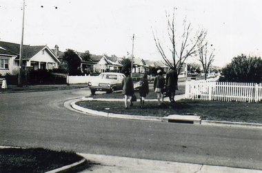
Photograph, Fellows Street, Mitcham, 1970
... road making... Mitcham melbourne mitcham fellowes street road making Black ...Black & white photograph of the northern end of Fellowes Street, Mitcham after it was made in c1970mitcham fellowes street, road making -
 Kew Historical Society Inc
Photograph, City of Kew, Public Works, Road Construction, c. 1920s
... road making construction... authority. engineering city of kew (engineering department) road ...An original photograph donated to the Kew Historical Society by the City's Engineering Department before the amalgamation of Kew into the City of Boroondara in 1994. While not all of the photographs are of Studley Park, Kew or East Kew, each photo provides a fine snapshot of the work of local government engineering departments of the period. They reveal they types of labour conducted, the techniques used and the equipment and machinery in the possession of the local government authority. Public works. A photograph of a suburban street under construction using a steamroller. The street was photographed to demonstrate the issues relating to grading. Neither the street nor the location has been identified. Inscription on reverse: "The construction of a roadway in a 1 in 3 1/2 grade. / The waggon is hauling the roller, by means of a cable attached to a pulley anchored at the top of the grade." engineering, city of kew (engineering department), road making construction -
 Port Fairy Historical Society Museum and Archives
Photograph, Jock Varcoe
... road making... beach development road making equipment street Coloured ...South Beach DevelopmentColoured photograph of Earth moving equipment cutting a road through South Beach Estatesouth beach, development, road making, equipment, street -
 Port Fairy Historical Society Museum and Archives
Photograph
... road making... beach development road road making equipment street Photograph ...South Beach Development south beach, development, road, road making, equipment, street -
 Port Fairy Historical Society Museum and Archives
Photograph
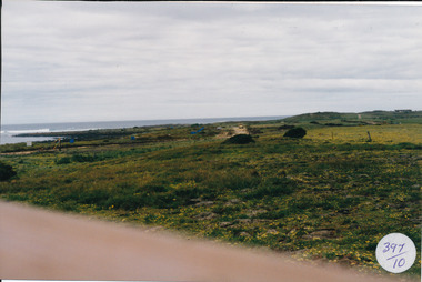
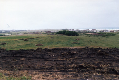
... Road making... beach development Road making street ocean sea Photograph ...South Beach Development south beach, development, road making, street, ocean, sea -
 Port Fairy Historical Society Museum and Archives
Photograph
... road making... beach development Road road making Photograph Photograph ...South Beach Development south beach, development, road, road making -
 Port Fairy Historical Society Museum and Archives
Photograph
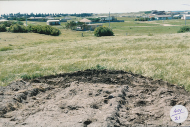
... road making... beach development houses road making Coloured photograph ...South Beach Development Coloured photograph of Earthworks in foreground with some housing on the South beach estate in backgroundsouth beach, development, houses, road making -
 Port Fairy Historical Society Museum and Archives
Photograph
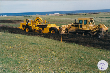
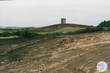
... road making... beach development water tower road making street earth works 407 ...South Beach Development Coloured photograph of Earthworks in foreground with Port Fairy Water tower in background407/25 (since removed 2021)south beach, development, water tower, road making, street, earth works -
 Port Fairy Historical Society Museum and Archives
Photograph
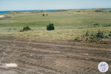
... road making... beach development road road making estate 397/10 (since removed ...South Beach Development Coloured photograph of South beach estate, blue marks are tree plantings along track397/10 (since removed 2021)south beach, development, road, road making, estate -
 Port Fairy Historical Society Museum and Archives
Photograph
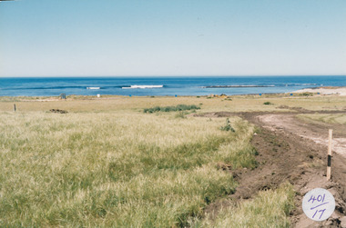
... road making... beach development road making street Coloured photograph ...South Beach Developement Coloured photograph of Earthworks in foreground with a tree shelter belt in middle distance and South Beach Estate in distancesouth beach, development, road making, street -
 Port Fairy Historical Society Museum and Archives
Photograph
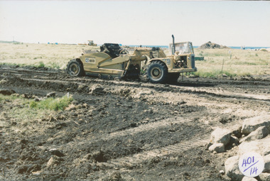
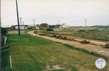
... road making... beach development road making ocean drive 408/6 since been ...South Beach Development Coloured photograph of Ocean Drive being graded and widened408/6 since been removed (2021)south beach, development, road making, ocean drive -
 Glenelg Shire Council Cultural Collection
Slide - Slide - Cashmore Airport, Portland, 1980s
... Coloured slide. Several road-making vehicles grouped... Cliff Street Portland great-ocean-road Portland Airport Cashmore ...Coloured slide. Several road-making vehicles grouped together in a jumble.portland airport, cashmore airport, construction, engineering -
Glenelg Shire Council Cultural Collection
Slide - Slide - Construction of Portland / Cashmore Airport, 1980s
... Coloured slide. Road making equipment and 2 workmen... Cliff Street Portland great-ocean-road Coloured slide. Road ...Coloured slide. Road making equipment and 2 workmen on runway site. -
![Photograph - Construction of the F19 [Eastern Freeway], Ron Setford, February 1975](/media/collectors/550653872162f11fb04854aa/items/682c460f5014d0f6bed69889/item-media/682c46335014d0f6bed69a13/item-fit-380x285.jpg) Kew Historical Society Inc
Kew Historical Society IncPhotograph - Construction of the F19 [Eastern Freeway], Ron Setford, February 1975
... "Road making / Feb 75 / Freeway near Belford Bridge"... locations. Ron Setford Eastern Freeway F19 Freeway "Road making ...Ron Setford and his wife Grace Setford lived in Tanner Avenue, East Kew, from c.1946 to c.1995. A keen photographer, he recorded the changing face of Kew over a 20 year period. Apart from 30 photographs of built structures and places in Kew dating from 1960 and 1961, 145 of his 35mm colour slides chronicle the development of the F19 (later renamed Eastern) Freeway through the Yarra Valley in Kew over a five year period from c.1972 to c.1977. This important collection was donated to the Society by his granddaughter in 2025.This collection of 175 35mm slides is of local and statewide significance, owing to its subject matter, particularly the major development of road transport infrastructure during the 1970s with the construction of the Eastern Freeway. The photographer also took care to annotate and date most of his slides which enable the researcher to pinpoint temporal and spatial locations.Chemically altered 35mm slide"Road making / Feb 75 / Freeway near Belford Bridge"ron setford, eastern freeway, f19 freeway -
 City of Moorabbin Historical Society (Operating the Box Cottage Museum)
Photograph, Black & White Horse drawn scoops earthwork in Moorabbin Shire c1900, c1900
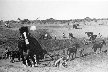
... to clear earth for road making. Well before the introduction... scoops guided by men to move earth for road making in Moorabbin... for road making. Well before the introduction of motorised ...The, horse drawn metal scoop ,guided by a man, was used to clear earth for road making. Well before the introduction of motorised, mechanical graders and trucks the painstaking, labour-intensive work was undertaken by large teams of sturdy men using strong horses such as the draught horse. Roads were needed by the market gardeners to transport their produce to market. Later as the heavy wagon loads continually caused ruts and general degradation of the roadways a Plateway system was installed so that the wagon wheels could roll along the rails thus protecting the roadways. August 31st 2021 Ron Nash, from WA, informs us "The men and horses pulling earth scoops in the photo are not moving earth for road making - they are excavating an "earth tank", or dam, as described in common nomenclature today. This skill was known as "tank sinking", and tank sinkers were active in many rural and remote areas in the 1800's and early 1900's, establishing sizeable dams for important water reserves for community and farm and railway use. With the advent of mechanised equipment such as bulldozers, the trade of tank sinking was still carried out, but on a faster basis. I am a former tank sinker and earth moving contractor, now long retired." Early settlers in Moorabbin Shire had to build the roads, plateways, drains, as the settlement of the land, in Dendy's Special Survey 1841 Brighton, spread and market gardeners need to transport their produce to market. Their most valuable possession was the draught horse that was used for ploughing, drawing carts and these scoops.Black & White photograph showing many horses pulling metal scoops guided by men to move earth for road making in Moorabbin Shire c 1900Back Handwritten Informationplateway, roadworks moorabbin shire, draught horses, metal scoops, paviers, box alonzo, smith j l; chaff cutter, horse drawn carts, toll gates brighton, motor cars 1900, steam engines, early settlers, bentleigh, mckinnon, parish of moorabbin, city of moorabbin, county of bourke, moorabbin roads board, shire of moorabbin, henry dendy's special survey 1841, were j.b.; bent thomas, o'shannassy john, king richard, charman stephen, highett william, ormond francis, maynard dennis, market gardeners, vineyards, orchards -
Glenelg Shire Council Cultural Collection
Slide - Slide - Cashmore Airport, Portland, 1980s
... Coloured slide. Road making equipment on runway site. Large.... Road making equipment on runway site. Large cloud of dust ...Coloured slide. Road making equipment on runway site. Large cloud of dust.portland airport, cashmore airport, construction, engineering, runway, air travel -
Glenelg Shire Council Cultural Collection
Slide - Slide - Construction Portland/Cashmore Airport, c. 1980
... Coloured slide. Run-way site. Several road-making vehicles... site. Several road-making vehicles. Clouds of dust. Slide Slide ...Coloured slide. Run-way site. Several road-making vehicles. Clouds of dust. -
Glenelg Shire Council Cultural Collection
Photograph - Photograph - PHT Harman Dragline, n.d
... on road making. Some Harbour Trust homes in the background... photo of earth moving equipment working on road making. Some ...Port of Portland Authority ArchiveBack: ? Monthly 2/12/57 - biro -
Glenelg Shire Council Cultural Collection
Slide - Slide - Cashmore Airport, Portland, 1980s
... Coloured slide. Run-way site. Several road-making vehicles...-way site. Several road-making vehicles. Clouds of dust ...Coloured slide. Run-way site. Several road-making vehicles. Clouds of dust. Cashmore airport construction site.portland airport, cashmore airport, air travel, engineering, construction -
 Eltham District Historical Society Inc
Photograph, 34 Brougham Street, Eltham, c.1988, 1988c
... Prior to road making and sealing in the late 1980s.... melbourne Prior to road making and sealing in the late 1980s. Colour ...Prior to road making and sealing in the late 1980s.Colour photograph -
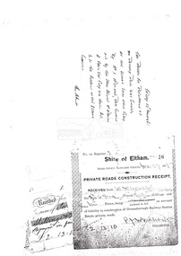 Eltham District Historical Society Inc
Document, Photocopy of receipts
... making of Rattray Road, 13 March 1965... making of Rattray Road, 13 March 1965 Greensborough Railway ...1. Private Roads Construction Receipt, Shire of Eltham for payment by W. McDonald on account of liability to construction of Greensborough Railway Station Estate private roads 2. Receipt for road making of Rattray Road, 13 March 1965Digital file only scanned by EDHS from item on loan (photocopy only)greensborough railway station estate, i. mcdonald, private roads, rattray road, receipt, road construction, w. mcdonald -
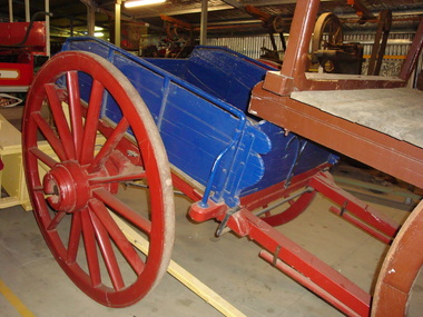 Maldon Vintage Machinery Museum Inc
Tip Dray, Late 19th century
... Used for carting rock to crushing batteries, road making... goldfields Used for carting rock to crushing batteries, road making ...Used for carting rock to crushing batteries, road making, railway track building.Single horse drawn tip dray, restored by G & S Little in 1999. Made of timber with metal fittings and wheel rims. Enclosed sides with hinged front and rear panels. Chassis and wheels painted dark red, body in dark blue.Rectangular brass plaque on LHS looking forward detailing restoration and possible usage.transport ..... horse-drawn -
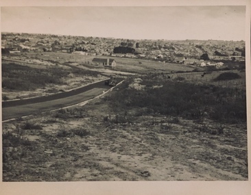
 Kew Historical Society Inc
Photograph - Urban landscape, 1860
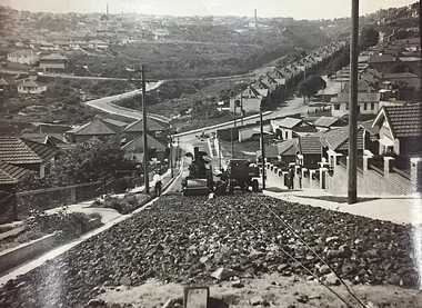
... . Road-making in foreground. Identical but sharper photo than.... Road-making in foreground. Identical but sharper photo than ...An item from an outstanding and diverse photographic collection, assembled by members of the Christian and Washfold families of Kew.Black and white photograph looking across a valley to buildings in the distance. Similar locations in nos.41, 42, 43, 44. Road-making in foreground. Identical but sharper photo than no.44.christian-washfold collection, landscape photography, subdivisions -- kew (vic.) -
 Kew Historical Society Inc
Photograph - Urban landscape, 1860
... . Road-making in foreground. Identical but paler photo than no.43..... Road-making in foreground. Identical but paler photo than no.43 ...An item from an outstanding and diverse photographic collection, assembled by members of the Christian and Washfold families of Kew.Black and white photograph looking across a valley to buildings in the distance. Similar locations in nos.41, 42, 43, 44. Road-making in foreground. Identical but paler photo than no.43.christian-washfold collection, landscape photography, subdivisions -- kew (vic.) -
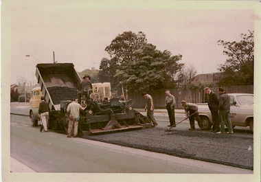 Kew Historical Society Inc
Photograph - Studley Park Road Reconstruction, 1968
... by a tray. Road workers supervise the road making. ... is then levelled by a tray. Road workers supervise the road making ...One of a series of photographs donated by the City Engineer of the former City of Kew, relating to road works. The photos variably include council workers, signage and equipment.One of a series of photographs of core local government services as practised by the City of Kew. The photographs are an accurate record of street works of the period. This example is one of the few shot in colour in the 1960s. Original colour photographic positive of roadworks in Studley Park Road in the former City of Kew. A tip truck carrying bitumen unloads it contents on the road which is then levelled by a tray. Road workers supervise the road making. "STUDLEY PARK ROAD RECONSTRUCTION / 1 1/2" NOM [sic] SIZE BIT BINDER COURSE / JANUS CONSTRUCTIONS / 9TH OCT 1968"city of kew, local government -- city of kew, road works, street works, studley park road -- kew (vic.) -
 Bendigo Historical Society Inc.
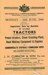
Document - IAN DYETT COLLECTION: AUCTION CATALOGUE - COMMONWEALTH DISPOSALS COMMISSION
... comprised of power graders, stone crushing plant, road making... comprised of power graders, stone crushing plant, road making ...White auction catalogue for a sale at the Commonwealth Disposals Commission Depot, Maribyrnong on 24 June, 1946. Sale comprised of power graders, stone crushing plant, road making equipment and engines. J. H. Curnow & Son Pty. Ltd. Were the auctioneers.business, auctioneers, j h curnow & son pty ltd, ian dyett collection - auction catalogue - commonwealth disposals commission, j h curnow & son pty ltd, j l jamieson, w g wedd, the prahran telegraph printing co