Showing 624 items
matching north road state school
-
 Ringwood and District Historical Society
Book - Attendance, Ringwood State School Attendance Book and Mothers' Club Attendance Book 1965-1966, 1965 - 1966
Used by the Mothers' Club of the Ringwood State School to record the individual member's attendances at meetings between 1965 and 1969.Book - Attendance. Pale burnt orange hard covered counter book with red cloth spine. Alphabetical index. Inscription in box (as below). 'Cancelled' handwritten across top left side. All pages used. Also - Ringwood State School Mothers Clubs - attendance book.Counter Book No 10841 Indexed -
Ringwood and District Historical Society
Attendance Book, Ringwood State School Mothers' Club Attendance Book 1967-1983, 1967-1983
Used by the Ringwood State School Mothers' Club for recording attendance at the Mothers Club meetings 1970-1972.Attendance book used by the Ringwood State School Mothers' Club for recording attendance at the Mothers Club meetings 1967-1983. Cream and grey mottled cardboard covered book with red cloth spine. All pages used.Ringwood State School Mothers' Club -
Ringwood and District Historical Society
Attendance Book, Ringwood State School Mothers' Club Attendance Book 1970-1972, 1970-1972
Used by the Ringwood State School Mothers' Club for recording attendance at the Mothers Club meetings 1970-1972.Attendance book used by the Ringwood State School Mothers' Club for recording attendance at the Mothers Club meetings 1970-1972. Brown covered book with red cloth spine with alphabetic index. All pages used.Ringwood State School Mothers' Club -
 Ringwood and District Historical Society
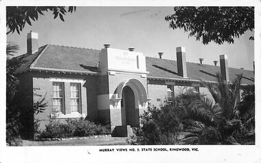
Photograph/Postcard, Postcard and souvenir photograph - Murray Views No. 5 - State School, Ringwood, Vic
Black and white "Murray Views" postcard and souvenir photograph - Ringwood State School, Greenwood Avenue, Ringwood. Circa 1950s.Post Card. Real Photograph Produced in Australia by Murray Views, Gympie, Q. -
 Ringwood and District Historical Society
Photograph, Ringwood Primary School 100th Anniversary - 1989
Coloured photograph"Written on back of photograph" 1989- State School- 100 year anniversary -
 Ringwood and District Historical Society
School Photographs, 1933 and 1935 Ringwood State School photos, 1933-35
Two photographs of the students at the Ringwood State School in 1933 (grade 2) and 1935 (grade 4) 1935 Photograph (7002a) L to R Back Row - Norm Brown, Milton Blood, Ken Ward, Athol Tilson, Ken Hill, Doug Highland, Bob Green, Jack Reynolds, David Allen, Graeme Morcom. 3rd Row - , , Hazel Morgan, Betty Adolpherson, Lorna Hill, , Elvie Hansy, Betty Reed, Valma Bassett, ? Hancock, Betty Stoney. 2nd Row ? Kelly, , , , , Valerie Anderson, Bernice Dixon, Betty Broadbent, , . Front row - Eddie Jackson, , Nally Hazelwood, Ron Ansell, Tom Young, Rupert Shearer, Eddie Flynn, Frank Lloyd, Lloyd Home, John Silby 1933 Photograph (7002b) L to R Back Row - Eddie Jackson, , Bob Green, Ken Manning, David Allen, Ron Hansel. 4th Row - Ken Ward, Tom young, Wally Hazelwood, Ken Thomas, Jack Reynolds, , Eddie Flynn, Graeme Morcom, Frank Lloyd. 3rd Row - Betty Walters, , , Helen Bond, Hazel Morgan, , , Elvie Hansy. 2nd Row - Milton Blood, Betty Stoney, Valma Bissett, Bernice Dixon, Jean Wright, Valerie Anderson, , , Betty Adolpherson, Lorna Hill. Front Row - Ken Hill, Lloyd Home, , Norman Windsor, Alan Knopp, , , Athol Tilson. Note 2/1/2019: Jan Adolphson emailed "Just wanted to say that my Auntie Betty is in both these pictures, 1933 and 1935 but her name is incorrectly spelt. should be Betty Adolphson ". (Rear of photographs state name as Betty Adolpherson). Both photographs are in post card form, made by Kodak. One is addressed "David Allen, Canterbury Road, Ringwood", the donor of the photographs. -
 Ringwood and District Historical Society
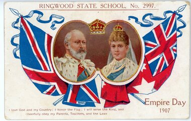
Postcard, Ringwood State School No 2997- Empire Day 1907
Coloured Postcard"Written on back of Postcard" With complements Mr Hocking -Ringwood State School Grace Curry - Ringwood Railway Station. -
Ringwood and District Historical Society
Research Folder, Ringwood State School: Uncatalogued research material
Directory containing various research material such as photographs, scanned documents. Items in the directory are uncatalogued at this stage. -
Ringwood and District Historical Society
Research Folder, Ringwood State School Students - Peter Fry Material: Uncatalogued research material
Directory containing various research material such as photographs, scanned documents. Items in the directory are uncatalogued at this stage. -
 Ringwood and District Historical Society
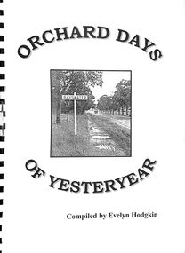
Book, Orchard Days of Yesteryear - Compiled by Evelyn Hodgkin, Bayswater, Victoria - Volume One, 1999
Brief history of Bayswater, Victoria, with memories, detailed stories and photographs of residents of Bayswater, Victoria. Cover photograph courtesy of Marj Crisp - taken outside Bayswater State School looking towards township. (c.1940s) -
 Ringwood and District Historical Society
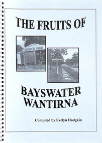
Book, The Fruits of Bayswater/Wantirna - Compiled by Evelyn Hodgkin - Volume Two, 2002
Compilation of recollections, detailed stories and photographs of residents of Bayswater/Wantirna area, Victoria. Front Cover - (left) Kleinert's Timber Yard, Station Street, Bayswater, 1940s (Photo courtesy Knox Historifcal Society); (right) Mountain Highway - outside Bayswater State School, looking towards township, 1940s. This photo courtesy of Marj Crisp. -
 Ringwood and District Historical Society
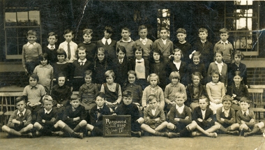
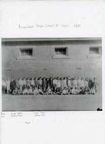
Photograph, Ringwood State School Class photograph. 1921
Black and white photograph with student names"Attached to photograph" List of student names (Incomplete) -
 Ringwood and District Historical Society
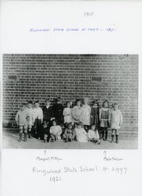
Photograph, Ringwood State School Class photograph. 1921
Black and white photograph with student names"Attached to photograph" List of student names (Incomplete) -
 Ringwood and District Historical Society
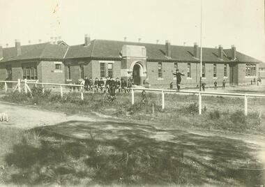
Photograph, Ringwood State School early class photographs. 1898 to1977
Sepia photographs (25) with negatives."Written on back of photograph" Ringwood Primary School 1922 - Building in Greenwood Ave -
 Ringwood and District Historical Society
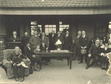
Photograph, Ringwood State School - Mr Broben's Farewell, 1931
Black and white photograph"Written on back of photograph" Mr Broben's Farewell, 1931 (See also 6904 - another image of Mr Broben's farewell) -
 Ringwood and District Historical Society
Photograph, Ringwood State School 1948 Grade 6 Class Photo
Two photographs"Attached to photograph" Back Row- L to R: ?, Philip Collins, Graeme Rattray, Paul Divola, Victor Jones, ? Beard, David Lewis, Bill Caird, Bill France, ?, ?, ?, ?. 2nd Row- L to R: ?, John Wigley, Marion Medhurst, Chris Patterson, ?, Nancy Painhall, ?, Nola Skurry, ?, ?, ?, ?, ?, ?. 3rd Row- L to R: Valerie Evelett, ?, ?, ?, ?, ?, ?, ?, ?, ?, ?. Front Row- L to R: ?, ?, ?, Ted Polkinghorn, ?, Robert Mathieson, ?, Russell Read, Brian Pump, ?, ?, Cliff Mead. Teacher: -
 Ringwood and District Historical Society
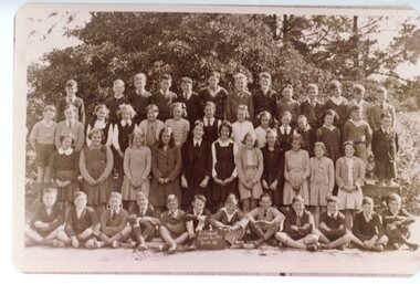
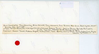
Photograph, Ringwood Primary School -Grade 2 1986
... Road Ringwood North melbourne Ringwood State School Names (1986 ...Colour photographRingwood State School Names (1986) Grade 2 Back Row- L to R: Paul Constellis, Troy Shanley, Brian Donald, Tony Aravanis, Paul Tsiokis, Alex Dinic, Mark Ingram, Stuart Rowley, Ben Collinson 2nd Row- L to R: Stuart Brown, Paul Eldridge, Christie Attwood, Rebecca Tauslii, Jasmina Pavlov, Belinda Poulinakis, Krista Terzioski, Heather Scott, Brenda Milgate Front Row- L to R: Naomi Terrell, Rebecca Rogers, YuShu Chen, Tara Barker, Carlie White, Emily Sykes, Carly Pryke. Teacher A.Tonkin. -
 Ringwood and District Historical Society
Photograph, Ringwood State School -Class photograph. Grade 6 -1986
... Road Ringwood North melbourne Ringwood State School- Grade 6 ...Colour photographRingwood State School- Grade 6, 1986 Back row- L to R: Joe Taualii, Johanne Kelaart, Steven Leadbetter, Troy Johnson, Chris Andronis, Peter Wah, Bradley Sanders 2nd Row- L to R: Jacqueline Hopgood, Caroline Neave, Rose Krisohos, Chrissy Lythow, Leena Daff, Mary Yiannaros, Alexandra Lohe, Jenny Webb Front row- L to R: Trudy Rowley, Claire Billingsley, Andrea Gorgdon, Natalie Hopgood, Megan Bilston, Debra Taylor, Heather Papadopoulos . Teacher C Adamson -
 Ringwood and District Historical Society
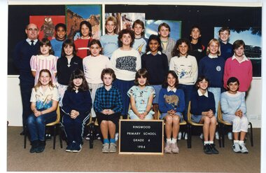
Photograph, Ringwood State School-Class photograph-Grade 4/5 1986
... Road Ringwood North melbourne Ringwood State School- Grade 4/5 ...Colour photographRingwood State School- Grade 4/5, 1986 Back Row- L to R: Greg Gozdz, Nathan Monk, John Mitchell, Rafe Itchins 2nd Row- L to R: Simon Herdina, Dean Smith, David Joyce, Julie Ann Billingsley, Atilla Erbasan, Darren Poulianakis, Craig Marden Front Row- L to R: Karen Green, Carey Postlethwaite, Susan Weaver, Jessica Taylor, Sukaina Rusack, Rachel Pilmore Teacher: P Bisset -
 Ringwood and District Historical Society
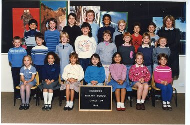
Photograph, Ringwood Primary School -Class photograph. Grade 3/4 1986
... Road Ringwood North melbourne Ringwood State School- Grade 3/4 ...Colour photographRingwood State School- Grade 3/4, 1986 Back Row- L to R: Claudio Toro, James Brown, Dylan Coulson, Misha Deikmann, Sean Pietersz, Ben Pearson, Geoffrey Harding, Peter Weaver 2nd Row- L to R: Ian Brown, Paul Grbac, Emma Rainey, Sandra Ralcliffe, Deanne Short, Narelle Elliot, Kelly Reinhardt, Justin Ross Front Row- L to R: Lea Adams, Rebecca Daotbar, Brooke Sinclair, Melissa Brushahan, Naney Belingerij, Kirsty Mclver, Michelle McLean. Teacher: J Stock -
 Ringwood and District Historical Society
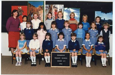
Photograph, Ringwood Primary School -Class photograph. Grade 2/3 1986
... Road Ringwood North melbourne Ringwood State School- Grade 2/3 ...Colour photographRingwood State School- Grade 2/3, 1986 Back Row- L to R: Robbie Walkely, Daniel Taylor, Wesley Sullivan, Ben Morgan, Jess Sinclair, Matthew McDougall 2nd Row - L to R: Joanne McCarthy, Nadia Razak, Sarah Monk, Rebecca Ramsden, Erika Rauschenbach, Adele Matthews, Natalie Turner Front Row- L to R: Mandy Milgate, Michelle Benson, Sarah Thorpe, Dana White, Rebecca Darlow, Jasmine Ozergin, Samantha Weaver. Teacher: G Williamson -
 Ringwood and District Historical Society
Photograph, Ringwood Primary School -Class photograph. Grade 1-1986
... Road Ringwood North melbourne Ringwood State School- Grade 1 ...Colour photographRingwood State School- Grade 1, 1986. Back Row- L to R: Chris Harrower, Matthew Lythow, Tim McCarty, Stuart, Vendle, Patrick Vendle, Patrick Mardan, Travis Mclver, Shane Reinhardt, Joshua White, Jason Clark 2nd Row- L to R: Matthew Monk, Marcus Grbac, Simon Terzioski, Tim Adams, Elizabeth Ball, Belinda Green, Nicole Betts, Kelly Thompson, Jeffrey Pearson, Lee Skinder, Warran Bartholomeusz Front Row- L to R: Louise Brown, Shea Bilston, Mary Katsandonis, Stacey Short, Christina te Lindert, Philippa Darlow Teacher: -
 Kiewa Valley Historical Society
Photo - School Children at Bogong School
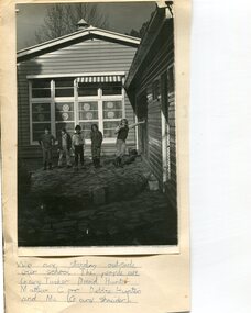
Bogong Primary School opened in 1941 to provide an education for the employees of the State Electricity Commission of Victoria. The school had up to date equipment and received glowing reports from school inspectors. It closed c1986.The Bogong State School was opened for the children of S.E.C.V. workers who lived in Bogong in a remote part of north east Victoria. The nearest school would have been 14 miles away and over mountain roads subject to heavy construction traffic and extremes of climatic conditionsBlack and white photograph of children standing outside Bogong Primary School (estimated mid to late 60's) Photo mounted on buff cardHandwritten underneath the photo - We are standing outside our school. The people are Gary Tusker, David Hunter, Matthew Corr, Debbie Hunter and me (Gary Schneider)bogong school, secv -
 Kiewa Valley Historical Society
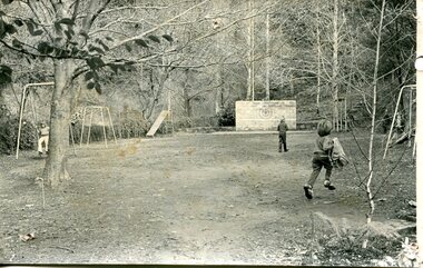
Photograph – black and white photograph of children playing in the school yard at Bogong Village Primary School, Circa late 1960s to early 1970’s
The early forties saw rapid growth of Bogong Village, with single and married men’s quarters, workshops, mess huts and administrative offices. The facilities necessary for communal living were quickly in place- a post office, police station, co-op store, medical centre, community hall/theatre, tennis courts and school. Bogong Primary School opened in 1941 to provide an education for the families of employees of the State Electricity Commission of Victoria. The school had up to date equipment and received glowing reports from school inspectors. It closed circa 1970.The Bogong State School was opened for the children of S.E.C.V. workers who lived in Bogong in a remote part of north east Victoria. The nearest school would have been 14 miles away and over mountain roads subject to heavy construction traffic and extremes of climatic conditionsBlack and white photograph of a group of 6 children playing on play equipment in the schoolyard at Bogong Primary School. The area is enclosed by tall trees in a bush-like settingbogong state school; secv; kiewa hydro electric scheme; -
 Kiewa Valley Historical Society
Bibs - Bogong Primary School
Bogong Primary School opened in 1941 to provide an education for the employees of the State Electricity Commission of Victoria. The school had up to date equipment and received glowing reports from school inspectors. It closed c1986.The Bogong State School was opened for the children of S.E.C.V. workers who lived in Bogong in a remote part of north east Victoria. The nearest school would have been 14 miles away and over mountain roads subject to heavy construction traffic and extremes of climatic conditions.6 bright orange 'bibs' from Bogong Primary School. Used to identify a team in eg. sport. Each bib has 2 coloured squares which are hemmed and joined to each other with 2 elastic pieces on the outside at the top (to fit over the head) and on each square joining the 2 squares, 2 white bias binding pieces on the outside at the bottom (for the arms to go through.)team bibs. bogong primary school. education. state school. -
 Warrnambool and District Historical Society Inc.
Document, Norman McDowell docket, 1950s
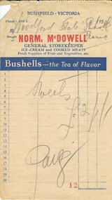
This is a docket indicating that the Woodford State school has purchased sweets in the 1950s for its annual picnic from Norm McDowell, a storekeeper at Bushfield. Bushfield and Woodford are small settlements seven kilometres north of Warrnambool. Woodford State School began in 1854 and is still operating today.No further information has been found on Norm McDowell but his general store was operating in the 1950sThis docket is of interest as the only memento we have of a Bushfield storekeeper some fifty tears agoA rectangular piece of paper torn from a dockets book. It has red, blue and cream text and some printed blue lines and figures. It also has hand written pencil notes. There is some damage in the top left hand corner. Norm. Mc Dowell GENERAL STOREKEEPER Sweets (Two Pounds, one shilling ) in symbols Paid. Woodford State School picnicbushfield, woodford state school -
 Eltham District Historical Society Inc
Photograph - Digital Photograph, Alan King, Original Kangaroo Ground Primary School No. 2105 building, Eltham-Yarra Glen Road, Kangaroo Ground, 28 December 2007
Kangaroo Ground's first school began in 1851 with 22 pupils from the district's ten families. It was a single room school located further south on the site, which also served as a Presbyterian church. The first teacher was Andrew Ross. The school building was used as a Post Office between 1854 and 1858 and during 1857 also served as a Court of Petty Sessions. With a growing farming community, a new building was warranted and the original Sate School No. 352 was closed and a new building, State School No. 2105 was oipened October 1, 1878. A residence for Head Teacher Henry Wallace School was erected in 1879 attached to the left of the school building. That residence is now home to the Andrew Ross Museum, which opened in 1993. Covered under Heritage Overlay, Nillumbik Planning Scheme. Published: Nillumbik Now and Then / Marguerite Marshall 2008; photographs Alan King with Marguerite Marshall.; p35This collection of almost 130 photos about places and people within the Shire of Nillumbik, an urban and rural municipality in Melbourne's north, contributes to an understanding of the history of the Shire. Published in 2008 immediately prior to the Black Saturday bushfires of February 7, 2009, it documents sites that were impacted, and in some cases destroyed by the fires. It includes photographs taken especially for the publication, creating a unique time capsule representing the Shire in the early 21st century. It remains the most recent comprehenesive publication devoted to the Shire's history connecting local residents to the past. nillumbik now and then (marshall-king) collection, kangaroo ground, eltham-yarra glen road, kangaroo ground primary school no. 2105, kangaroo ground state school, state school no. 2105 -
 Eltham District Historical Society Inc
Album - Photograph Album, J.A. McDonald, Bridge and Road Reconstruction Works, Shire of Eltham, 1952-1962
J.A. McDonald produced this record in the course of his responsibilities as Shire Engineer for Eltham Shire Council.Record of various Shire of Eltham infrastructure works undertaken during the period of 1952-1962 involving bridge and road reconstruction projects, sometimes with Eltham Shire Council Project Reference numbers quoted. It was during this period that a number of significant improvements were made to roads and new bridges constructed within the shire that remain in place as of present day (2022). In many situations, the photos provide a tangible visible record of infrastructure that existed throughout the early days of the Shire. The album was put together by or under the direction of the Shire Engineer, J.A. McDonald.a. gillies, alistair knox park, benchmark studies, bend of islands, blease road, box hill state school, box hill teachers college, box hill tip, bridge construction, bridge street bridge, bridge, brisbane street, brougham steet, bulldozer, cecil street, charis pelling, cherry tree road, city of preston, cr. a. brinkkotter, cr. charis pelling, cranes, cromwell street, diamond creek (creek), diamond street, dixons creek bridge, dixon's creek road, drott, eltham leisure centre, eltham north, eltham police station, eltham, eltham-yarra glen road, f. wood, fitzsimons lane bridge, flat rock road, flood damage, floods, floodwater, footpaths and gutters, ford service garage, g. blair, garden hill, glen park bridge, glenauburn road, grand hotel, haldane road, healesville, healesville-yarra glen road, heidelberg-kinglake road, henley road bridge, henley road, hill property, hurstbridge water scheme, hurstbridge, hurstbridge-arthurs creek road, infrastructure, j. jolly, kangaroo ground, kangaroo ground-queenstown road, kangaroo ground-st andrews road, lilydale shire office, long gully bridge, long gully creek, long gully road, long gully, lower plenty bridge, lower plenty footbridge, lower plenty oval, lower plenty road, lower plenty, main road, methodist church, montmorency, mount pleasant road, new holland, old healesville road, opening ceremony, oxley bridge, para road, paul creek bridge, paul creek road, paul krafeznk, pinnacle lane, plaques, plenty river trail, plenty river, presbyterian church, prof donald thomson, pryor street, railway crossing, railway parade, rattray road, reconstruction works, reichelt avenue, research (vic.), research oval, road construction, rymers corner, shire of eltham, shire of whittlesea, silvan road bridge, silver street bridge, silver street, sir dallas brooks, smedley property, st andrews, steels creek, susan street, tarrawarra, tony carberry, uniting church, upper yarra dam, upper yarra reservoir, w.e. wolf, waterfall property, watsons creek, wattletree road bridge, wattletree road, wattletree road bridge, worlingworth, yarra glen, york street, yow yow creek -
 Eltham District Historical Society Inc
Photograph - Aerial Photograph, Landata, Eltham; Crown Allotment 15, Section 5, Parish of Nillumbik (Stokes Orchard Estate), Dec. 1945
Centred on present day Diosma Rd, Stokes Pl, Nyora Rd and Eucalyptus Rd Historic Aerial Imagery Source: Landata.vic.gov.au Aerial Photo Details: Project No :5 Project : MELBOURNE AND METROPOLITAN AREA PROJECT Run : 36 Frame : 60546 Date : 12/1945 Film Type : B/W Camera : EAG4 Flying Height : 10200 Scale : 6000 Film Number : 195 GDA2020 : 37°42'47"S, 145°09'56"E MGA2020 : 338306, 5824438 (55) Melways : 22 C4 (ed. 42) A History of the Development of Crown Allotment 15, Section 5, Parish of Nillumbik – Stokes Orchard Crown Allotment 15, Section 5, Parish of Nillumbik (CA15) is a square allotment of 158 acres or approximately a quarter of a square mile. It lies just beyond the eastern end of Pitt Street, south of Nyora Road to the northern end of Eucalyptus Road and extends east from Eucalyptus Road to Reynolds Road. The topography of CA15 is generally steep, sloping up to a hill near the centre of the land, the ridgeline passing through the properties along the southern side of Diosma Road. Eucalyptus Road is a straight north-south road with its northern end at the north west corner of CA15. Until the end of the 1970s this road was an un-named Government Road and was largely not open to traffic. With residential development in the 1970s the road was constructed, and the council allocated the name obviously in recognition of the predominant species of the local bushland. CA15 was purchased from the Crown by George D’Arley Boursiquot, a prominent Melbourne printer, on 28th October 1852. On November 23, 1922, former Member for Gippsland and Melbourne Real Estate Agent, Hubert Patrick Keogh purchased the allotment then sold it March 13, 1925, to local farmer, Robert David Taylor, a former Shire of Eltham Councillor (1911-1920) and Shire President (1919). Taylor had extensive land holdings stretching west towards Bible Street and Main Road. The Taylor home was situated at the top of the hill in Bible Street at present day 82 Bible Street. At the time of Taylor’s purchase in 1925, CA15 was subdivided into 48 lots that could be described as small rural properties or large residential lots. A typical lot size was one hectare or 2.5 acres. The subdivision created two roads, Nyora Road, and Diosma Road, each following an irregular alignment between Eucalyptus and Reynolds Roads. However, the lots were not sold off separately nor were the roads constructed. The land effectively remained as one parcel for many further years. Robert David Taylor died November 30, 1934, and probate was granted to his son of the same name, Robert David Taylor of Bible Street, Salesman and William McLelland Vance Taylor of 73 Emmeline Street, Northcote, Clerk, with the transfer of the land into their names on July 8, 1935. Frank Stokes worked as a qualified accountant at Kennons leather factory in Burnley, while living at 1 Thomas Street, Mitcham. He suffered from migraines and wanted to return to working the land (he had previously worked on farms and orchards since coming to Australia from England in 1926, both in WA and Vic.). He first travelled to the district by train in July 1942 to find land with the intention to establish an orchard. By chance he met Arthur Bird of Bird Orchard (bounded by Pitt Street, Eucalyptus Road, and Wattle Grove) and they got talking over their common interest. Arthur put Frank up for the night and pointed out the land, 158 acres- part of the Taylor Estate- £900, Crown Allotment 15, Section 5, Parish of Nillumbik (CA15) somewhat diagonally opposite Bird Orchard. Stokes applied through the Riverina Agency to purchase the land who in turn applied for permission from Canberra to sell as there was a new government regulation introduced during the Second World War banning land sales except for immediate production. Stokes obtained a loan on his Mitcham house of £600 @ 5% and paid £450 deposit with quarterly payments of £15 spread over 5 years. Stokes was assisted and advised by Arthur Bird who farmed the neighbouring orchard. In early 1943 Stokes took possession and would catch the train out to Eltham on Fridays after work and began building a hut on the corner of Nyora Road and the Government Road (Eucalyptus Road) for shelter and to lock up tools. He established an orchard on the central western part of the land through the centre of which ran a natural waterway (part of the present-day linear park) and was able to pay a neighbour (Hawkins) to help with clearing and fencing 25 acres, and with a horse and single furrowed plough, planted approximately 2,500 fruit trees - cherries, peaches, plums, almonds, pears, apricots and lemons as well as a few apples and oranges; a massive task. Aerial photographs from the 1940s through to the 1990s clearly show the orchard with most of the larger CA15 site remaining as natural bushland. A huge problem was hares and rabbits eating all the new buds off the tiny trees. As well as laying poison he painted the trees with a mixture of cow manure and lime, often working by moonlight. Procurement of wire and wire netting was difficult because of the war but after much effort he obtained a permit from the Agricultural Department for supplies in March 1944. In February 1945 Stokes applied for a permit to build a “packing shed” as no house building was allowed. It was to be 33 feet x 21 feet and cost £312. It was constructed mostly from second-hand materials, which were hard to obtain, especially iron for roofing. Stokes finished work at Kennons on October 31, 1945, and in March 1946 he sold the family home at Mitcham for £1,230 plus £170 for furniture. On May 15, 1946, title to the CA15 property was issued to Frank Howard Alfred Stokes, Orchardist and Gladys Ethel Stokes, Married Woman, both of Pitt Street, Eltham. The family of five then moved into the very unfinished “packing shed” at Eltham, which was a struggle to weatherproof. Eventually rooms were divided off and lined with hessian bags and whitewashed. Their income was firewood (cut and sold), selling rockery stones and cut Sweet Bursaria. (It was discovered during the 1940s that Sweet Bursaria contained the sunscreen compound Aesculin. The RAAF utilised this compound from Sweet Bursaria during WW2 for pilots and gunners.) The orchard’s first fruit sale was a half-case of Le Vanq peaches in December 1947 for the price of 8 shillings. In 1956 plans for house were drawn and Glen Iris bricks purchased (1956 Olympic Rings variant). The building of the house commenced in 1957 - 12 feet of original packing shed was removed – and was completed in 1959. Water was connected from newly built pressure storage on the property at the end of 1959 and the electricity connection for the first time at 3pm on April 29, 1960. The house remains to present day (somewhat modified) at 1 Nyora Road, home to Nyora Studio Gallery. On occasions, spare remnants of the 1956 bricks have been known to be unearthed in gardens on the estate as they were utilised by Frank Stokes to fill in rabbit holes. On May 26, 1950, a parcel of land was compulsorily acquired by the Melbourne and Metropolitan Board of Works on the hilltop to establish an easement for a high-level service reservoir to augment Eltham’s water supply. The project also included pipe tracks for the necessary water mains. The reservoir has now been superseded by higher level water tanks east of Reynolds Road and its former site is now a public reserve. On November 27, 1964, the State Electricity Commission served notice to compulsorily acquire a further parcel through the eastern part of the land for a major electricity transmission line that augmented supply from the La Trobe Valley to Melbourne. The easement was registered February 11, 1966. The easement was widened July 18, 1969 for a second transmission line to be constructed. In 1971 Melbourne Metropolitan Planning Scheme amendments adopted Nyora Road as the boundary between a residential zone to the north and a rural zone to the south. This determined the future development of the land. In the mid-1970s the Shire of Eltham divided the orchard into numerous rate-able parcel lots, the 48 lots having been established in 1925 and the subsequent rates assessment proved unsustainable for Stokes. He commenced selling lots outside the boundary of the orchard, north of Diosma and South of Nyora. However shortly later the land between Nyora and Diosma Roads and west of the electricity easement was sold and subdivided into residential lots, a housing development by Macquarie Builders and marketed as the Stokes Orchard Estate. New streets were created, and most were named after trees, although one, Stokes Place, commemorates the former owners. The development was undertaken in two stages; Stage 1 (1975) encompassing Scarlet Ash Court, Ironbark Close and Peppermint Grove bounded by Nyora and Eucalyptus roads and Stage 2 (1978) encompassing Stokes Place, Orchard Way, The Crest and The Lookout bound by Nyora and Diosma roads. The developer, Macquarie Builders went bankrupt shortly after the release of Stage 2 leaving many purchasers to fend for themselves and arrange for their own independent builders. There were also difficulties with sewerage for the land immediately south of Diosma Road and so the conventional residential lots were abandoned in favour of larger lots. The development of Orchard Way, The Crest and The Lookout did not proceed as planned and the proposed lots were incorporated into five-acre parcels instead. These included a low-density group housing development by the Graves family and the award winning Choong House (1983) with Gordon Ford developed garden immediately next door situated on the ridge of the hill nestled amongst the original bush, Eucalypt trees and Sweet Bursaria. In 1994, Nillumbik Shire Council applied Significant Environment and Significant Landscape overlays upon the properties on the south side of Diosma Road to ensure protection of this natural bush garden environment. With the arrival of the sewer along Diosma Road in the 1990s, most of these five-acre parcels have since been subdivided multiple times. The Choong house presently sits on a 2.7-acre property, which in 2022 Nillumbik Council nominated for Cultural Significance Heritage protection and is considered potentially significant at State level. The Stokes family were also associated with the Eltham Christian Church. In the 1970s this church had met in temporary premises in Eltham. Lots of the original 1925 subdivision remained south of Nyora Road and a number of these lots were utilized for the Eltham Christian School, which was established by the Eltham Christian Church in 1981. The school operated on this site until 2000. The premises are now used by The Vine Baptist Church. By the mid-1980s the whole of CA15 had been developed for residential and school purposes, except for the sections north of Diosma Road and between the transmission lines and Reynolds Road. Sewerage issues had been resolved for the section north of Diosma Road and in 1987 it was in the process of being subdivided into residential lots. The development coincided with the discovery of colonies of the rare and endangered Eltham Copper Butterfly on the site. This resulted in a community and political campaign to save the butterfly habitat. With the co-operation of the land developer the subdivision was altered to create two bushland reserves in the critical butterfly habitat areas. In the late 1980s the State Government was investigating options for establishing a metropolitan ring road link between Diamond Creek and Ringwood. The chosen route was adjacent to Reynolds Road and so this created a freeze on development of CA15 between Reynolds Road and the electricity easement. The ring road proposal was eventually abandoned, and this part of the land was subdivided into low density residential lots. Diosma Road has been discontinued at the electricity easement and the eastern part incorporated into View Mount Court with access from Reynolds Road. The whole of CA15 has now been developed for residential or associated purposes, ranging from conventional density to quite low density south of Nyora Road. Some remnants of the orchard remain, a few cherry trees on the Graves property and a lone apple tree in Stokes Place. The butterfly reserves comprise significant areas of remnant bushland. Linear reserves through the estate link with central Eltham via the Woodridge linear reserve and with Research along the electricity easement. CA15 as it exists today has a complicated history of rural use, Government acquisition, urban development, and community action. References: • “Stokes Orchard, an incomplete history”; Russell Yeoman with Doug Orford • Correspondence, Beryl Bradbury (nee Stokes) • Aerial Photographs, 1931-1991, Landata (landata.vic.gov.au) • Certificate of Title, Vol. 4930 Fol. 985900 • Plan Number LP 10859 aerial photo, diosma road, eltham copper butterfly, eucalyptus road, ironbark close, nyora road, peppermint grove, peter & elizabeth pidgeon collection, power transmission lines, reynolds road, scarlet ash court, stokes orchard estate, stokes place, woodridge estate, frank stokes -
 Eltham District Historical Society Inc
Photograph - Aerial Photograph, Landata, Eltham; Crown Allotment 15, Section 5, Parish of Nillumbik (Stokes Orchard Estate), Nov. 1931
Centred over present day Reynolds Road and Mount Pleasant Road, Eltham (including Diosma Rd, Stokes Pl, Nyora Rd and Eucalyptus Rd) Historic Aerial Imagery Source: Landata.vic.gov.au Aerial Photo Details: Project No :1931 Project : MALDON PRISON Run : 21 Frame : 3160 Date : 11/1931 Film Type : B/W Camera : F8 Flying Height : 11000 Scale : 18860 Film Number : 60 GDA2020 : 37°43'31"S, 145°10'20"E MGA2020 : 338912, 5823086 (55) Melways : 22 E8 (ed. 42) A History of the Development of Crown Allotment 15, Section 5, Parish of Nillumbik – Stokes Orchard Crown Allotment 15, Section 5, Parish of Nillumbik (CA15) is a square allotment of 158 acres or approximately a quarter of a square mile. It lies just beyond the eastern end of Pitt Street, south of Nyora Road to the northern end of Eucalyptus Road and extends east from Eucalyptus Road to Reynolds Road. The topography of CA15 is generally steep, sloping up to a hill near the centre of the land, the ridgeline passing through the properties along the southern side of Diosma Road. Eucalyptus Road is a straight north-south road with its northern end at the north west corner of CA15. Until the end of the 1970s this road was an un-named Government Road and was largely not open to traffic. With residential development in the 1970s the road was constructed, and the council allocated the name obviously in recognition of the predominant species of the local bushland. CA15 was purchased from the Crown by George D’Arley Boursiquot, a prominent Melbourne printer, on 28th October 1852. On November 23, 1922, former Member for Gippsland and Melbourne Real Estate Agent, Hubert Patrick Keogh purchased the allotment then sold it March 13, 1925, to local farmer, Robert David Taylor, a former Shire of Eltham Councillor (1911-1920) and Shire President (1919). Taylor had extensive land holdings stretching west towards Bible Street and Main Road. The Taylor home was situated at the top of the hill in Bible Street at present day 82 Bible Street. At the time of Taylor’s purchase in 1925, CA15 was subdivided into 48 lots that could be described as small rural properties or large residential lots. A typical lot size was one hectare or 2.5 acres. The subdivision created two roads, Nyora Road, and Diosma Road, each following an irregular alignment between Eucalyptus and Reynolds Roads. However, the lots were not sold off separately nor were the roads constructed. The land effectively remained as one parcel for many further years. Robert David Taylor died November 30, 1934, and probate was granted to his son of the same name, Robert David Taylor of Bible Street, Salesman and William McLelland Vance Taylor of 73 Emmeline Street, Northcote, Clerk, with the transfer of the land into their names on July 8, 1935. Frank Stokes worked as a qualified accountant at Kennons leather factory in Burnley, while living at 1 Thomas Street, Mitcham. He suffered from migraines and wanted to return to working the land (he had previously worked on farms and orchards since coming to Australia from England in 1926, both in WA and Vic.). He first travelled to the district by train in July 1942 to find land with the intention to establish an orchard. By chance he met Arthur Bird of Bird Orchard (bounded by Pitt Street, Eucalyptus Road, and Wattle Grove) and they got talking over their common interest. Arthur put Frank up for the night and pointed out the land, 158 acres- part of the Taylor Estate- £900, Crown Allotment 15, Section 5, Parish of Nillumbik (CA15) somewhat diagonally opposite Bird Orchard. Stokes applied through the Riverina Agency to purchase the land who in turn applied for permission from Canberra to sell as there was a new government regulation introduced during the Second World War banning land sales except for immediate production. Stokes obtained a loan on his Mitcham house of £600 @ 5% and paid £450 deposit with quarterly payments of £15 spread over 5 years. Stokes was assisted and advised by Arthur Bird who farmed the neighbouring orchard. In early 1943 Stokes took possession and would catch the train out to Eltham on Fridays after work and began building a hut on the corner of Nyora Road and the Government Road (Eucalyptus Road) for shelter and to lock up tools. He established an orchard on the central western part of the land through the centre of which ran a natural waterway (part of the present-day linear park) and was able to pay a neighbour (Hawkins) to help with clearing and fencing 25 acres, and with a horse and single furrowed plough, planted approximately 2,500 fruit trees - cherries, peaches, plums, almonds, pears, apricots and lemons as well as a few apples and oranges; a massive task. Aerial photographs from the 1940s through to the 1990s clearly show the orchard with most of the larger CA15 site remaining as natural bushland. A huge problem was hares and rabbits eating all the new buds off the tiny trees. As well as laying poison he painted the trees with a mixture of cow manure and lime, often working by moonlight. Procurement of wire and wire netting was difficult because of the war but after much effort he obtained a permit from the Agricultural Department for supplies in March 1944. In February 1945 Stokes applied for a permit to build a “packing shed” as no house building was allowed. It was to be 33 feet x 21 feet and cost £312. It was constructed mostly from second-hand materials, which were hard to obtain, especially iron for roofing. Stokes finished work at Kennons on October 31, 1945, and in March 1946 he sold the family home at Mitcham for £1,230 plus £170 for furniture. On May 15, 1946, title to the CA15 property was issued to Frank Howard Alfred Stokes, Orchardist and Gladys Ethel Stokes, Married Woman, both of Pitt Street, Eltham. The family of five then moved into the very unfinished “packing shed” at Eltham, which was a struggle to weatherproof. Eventually rooms were divided off and lined with hessian bags and whitewashed. Their income was firewood (cut and sold), selling rockery stones and cut Sweet Bursaria. (It was discovered during the 1940s that Sweet Bursaria contained the sunscreen compound Aesculin. The RAAF utilised this compound from Sweet Bursaria during WW2 for pilots and gunners.) The orchard’s first fruit sale was a half-case of Le Vanq peaches in December 1947 for the price of 8 shillings. In 1956 plans for house were drawn and Glen Iris bricks purchased (1956 Olympic Rings variant). The building of the house commenced in 1957 - 12 feet of original packing shed was removed – and was completed in 1959. Water was connected from newly built pressure storage on the property at the end of 1959 and the electricity connection for the first time at 3pm on April 29, 1960. The house remains to present day (somewhat modified) at 1 Nyora Road, home to Nyora Studio Gallery. On occasions, spare remnants of the 1956 bricks have been known to be unearthed in gardens on the estate as they were utilised by Frank Stokes to fill in rabbit holes. On May 26, 1950, a parcel of land was compulsorily acquired by the Melbourne and Metropolitan Board of Works on the hilltop to establish an easement for a high-level service reservoir to augment Eltham’s water supply. The project also included pipe tracks for the necessary water mains. The reservoir has now been superseded by higher level water tanks east of Reynolds Road and its former site is now a public reserve. On November 27, 1964, the State Electricity Commission served notice to compulsorily acquire a further parcel through the eastern part of the land for a major electricity transmission line that augmented supply from the La Trobe Valley to Melbourne. The easement was registered February 11, 1966. The easement was widened July 18, 1969 for a second transmission line to be constructed. In 1971 Melbourne Metropolitan Planning Scheme amendments adopted Nyora Road as the boundary between a residential zone to the north and a rural zone to the south. This determined the future development of the land. In the mid-1970s the Shire of Eltham divided the orchard into numerous rate-able parcel lots, the 48 lots having been established in 1925 and the subsequent rates assessment proved unsustainable for Stokes. He commenced selling lots outside the boundary of the orchard, north of Diosma and South of Nyora. However shortly later the land between Nyora and Diosma Roads and west of the electricity easement was sold and subdivided into residential lots, a housing development by Macquarie Builders and marketed as the Stokes Orchard Estate. New streets were created, and most were named after trees, although one, Stokes Place, commemorates the former owners. The development was undertaken in two stages; Stage 1 (1975) encompassing Scarlet Ash Court, Ironbark Close and Peppermint Grove bounded by Nyora and Eucalyptus roads and Stage 2 (1978) encompassing Stokes Place, Orchard Way, The Crest and The Lookout bound by Nyora and Diosma roads. The developer, Macquarie Builders went bankrupt shortly after the release of Stage 2 leaving many purchasers to fend for themselves and arrange for their own independent builders. There were also difficulties with sewerage for the land immediately south of Diosma Road and so the conventional residential lots were abandoned in favour of larger lots. The development of Orchard Way, The Crest and The Lookout did not proceed as planned and the proposed lots were incorporated into five-acre parcels instead. These included a low-density group housing development by the Graves family and the award winning Choong House (1983) with Gordon Ford developed garden immediately next door situated on the ridge of the hill nestled amongst the original bush, Eucalypt trees and Sweet Bursaria. In 1994, Nillumbik Shire Council applied Significant Environment and Significant Landscape overlays upon the properties on the south side of Diosma Road to ensure protection of this natural bush garden environment. With the arrival of the sewer along Diosma Road in the 1990s, most of these five-acre parcels have since been subdivided multiple times. The Choong house presently sits on a 2.7-acre property, which in 2022 Nillumbik Council nominated for Cultural Significance Heritage protection and is considered potentially significant at State level. The Stokes family were also associated with the Eltham Christian Church. In the 1970s this church had met in temporary premises in Eltham. Lots of the original 1925 subdivision remained south of Nyora Road and a number of these lots were utilized for the Eltham Christian School, which was established by the Eltham Christian Church in 1981. The school operated on this site until 2000. The premises are now used by The Vine Baptist Church. By the mid-1980s the whole of CA15 had been developed for residential and school purposes, except for the sections north of Diosma Road and between the transmission lines and Reynolds Road. Sewerage issues had been resolved for the section north of Diosma Road and in 1987 it was in the process of being subdivided into residential lots. The development coincided with the discovery of colonies of the rare and endangered Eltham Copper Butterfly on the site. This resulted in a community and political campaign to save the butterfly habitat. With the co-operation of the land developer the subdivision was altered to create two bushland reserves in the critical butterfly habitat areas. In the late 1980s the State Government was investigating options for establishing a metropolitan ring road link between Diamond Creek and Ringwood. The chosen route was adjacent to Reynolds Road and so this created a freeze on development of CA15 between Reynolds Road and the electricity easement. The ring road proposal was eventually abandoned, and this part of the land was subdivided into low density residential lots. Diosma Road has been discontinued at the electricity easement and the eastern part incorporated into View Mount Court with access from Reynolds Road. The whole of CA15 has now been developed for residential or associated purposes, ranging from conventional density to quite low density south of Nyora Road. Some remnants of the orchard remain, a few cherry trees on the Graves property and a lone apple tree in Stokes Place. The butterfly reserves comprise significant areas of remnant bushland. Linear reserves through the estate link with central Eltham via the Woodridge linear reserve and with Research along the electricity easement. CA15 as it exists today has a complicated history of rural use, Government acquisition, urban development, and community action. References: • “Stokes Orchard, an incomplete history”; Russell Yeoman with Doug Orford • Correspondence, Beryl Bradbury (nee Stokes) • Aerial Photographs, 1931-1991, Landata (landata.vic.gov.au) • Certificate of Title, Vol. 4930 Fol. 985900 • Plan Number LP 10859 aerial photo, diosma road, eltham copper butterfly, eucalyptus road, ironbark close, nyora road, peppermint grove, peter & elizabeth pidgeon collection, power transmission lines, reynolds road, scarlet ash court, stokes orchard estate, stokes place, woodridge estate, frank stokes