Showing 80 items
matching plan of changing house
-
 Eltham District Historical Society Inc
Slide, Adam Crescent, Montmorency, c. Feb. 1981
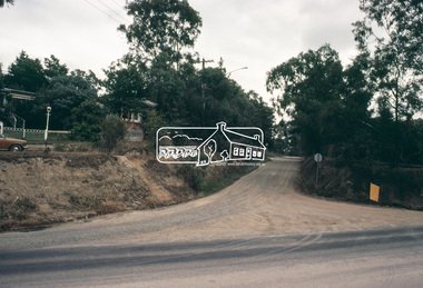
One of a series of images of road infrastructure focussed on Adam Crescent in Montmorency taken by Eltham Shire Council Planning and Engineering officers. They provide perspective of the changes in housing styles and road development that began sweeping in from the mid 1970s with increasing urbanisation of what was once more outlying suburbs and regions. All images have been identified with GPS though house numbers have changed35 mm colour positive transparency (1 of 21) Mount - Kodak Kodachrome CardProcessed Feb 1981adam crescent, infrastructure, montmorency, roads, sherbourne road -
 Eltham District Historical Society Inc
Slide, Adam Crescent, Montmorency, c. Feb. 1981
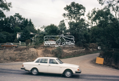
One of a series of images of road infrastructure focussed on Adam Crescent in Montmorency taken by Eltham Shire Council Planning and Engineering officers. They provide perspective of the changes in housing styles and road development that began sweeping in from the mid 1970s with increasing urbanisation of what was once more outlying suburbs and regions. All images have been identified with GPS though house numbers have changed35 mm colour positive transparency (1 of 21) Mount - Kodak Kodachrome CardProcessed Feb 1981adam crescent, infrastructure, montmorency, roads, sherbourne road -
 Eltham District Historical Society Inc
Slide, Adam Crescent, Montmorency, c. Feb. 1981
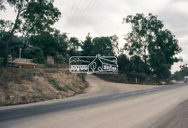
One of a series of images of road infrastructure focussed on Adam Crescent in Montmorency taken by Eltham Shire Council Planning and Engineering officers. They provide perspective of the changes in housing styles and road development that began sweeping in from the mid 1970s with increasing urbanisation of what was once more outlying suburbs and regions. All images have been identified with GPS though house numbers have changed35 mm colour positive transparency (1 of 21) Mount - Kodak Kodachrome CardProcessed Feb 1981adam crescent, infrastructure, montmorency, roads, sherbourne road -
 Halls Gap & Grampians Historical Society
Newspaper - B/W
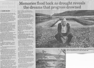
Until the closure 40 years ago, the Myrtlebank Guesthouse near Halls Gap in the Grampians was a thriving family - run business. In 1962, all that changed when the government of the day purchased the land on which the guesthouse stood and some neighbouring farms and houses. For almost 40 Years, the remains of the buildings have been submered under the man made reservoir known as Lake Bellfield. Due to drought, the eater levels have dropped steadily and, in the past month, the memories underneath Lake Bellfield have come to the surface. Local resident Don warren 70, has been to have a look. His grandmother Anne Flower Warren, was 56 when she opened the guesthouse in 1916. Widowed, the year before after a horse kicked her farmer husband, Mrs Flower needed to provide for their large family. "She had 13 children - seven daughters. I think she built it to look after the girls," Mr Warren says, "The whole think was built on a 500 acre farm." With the guesthouse sited in the centre of the farm, the land was divided between two of her sons- Mr Warren's uncle working one side and his father taking the other. For Mr Warren, the grounds of the two-storey guesthouse were an extension of a huge rural playground in what he remembers as an idyllic childhood. "I used to get taken over there and I'd sit there and watch her make all the toast for the guests. It was quite full all the time - maybe 40 or 50 people. It was a great big place - very grand. In the bedrooms I can remember the great big bowls full of water to wash your face in. There was a big dining room, too. My grandmother was a great cook." By the time of Mrs Warren's death in 1936, her eldest daughter also Anne, had officially taken over the running of the business. "It was in the family right until the last bit. The youngest daughter, Auntie Hilda, took it over right at the end. they got a notice to say that's it - it's over There was no way out of that one." Mrs Ida Stanton, 78, is the historian for the Halls Gap and Grampians Historical Society. Can she remember it when it all happened? "Of course" she says "It's only 40 years ago" Her memories of Myrtlebank are of a place popular with honeymooners, who would often return year after year, bringing their families with them. "There was a lovely ballroom where they used to invite the Gap people and the tourists in to have balls. During the war it was one means of making money to send stuff over to the soldiers." Seeing just the stumps of the guesthouse and what had been his family home, Mr Warren says the bitterness is still there. "The hardest part was poor old dad. He was 70 years old when he got turfed out. Dad had been a farmer all his life - 214 acres, he had, and he got 22,000 quid. Had to move into town" Also showing beneath the drying lake is the concrete slab of the new home Mr Warren planned after his marriage to wife Anne in 1955. Another lost dream. " I was the only child, I was going to take over the farm, but that all changed. You can't take it over when it's full of water.Newspaper clipping of history of Myrtlebank by Don Warren and photo of Don at old site of pooland guest House photo Article by Claire Halliday from newspaper 2002accommodation, guesthouses, myrtlebank -
 Federation University Historical Collection
Photograph - Black and White, Former Ballarat Library, c1960
First known development on this site was the establishment of the Government Camp from the early 1850s. It was established to accommodate officials, troopers and police who were needed to administer the goldfields. Some permanent buildings were constructed. Lack of materials and bad weather prolonged the building of more permanent buildings and most men were still living in tents. Area was known as Camp Reserve. In 1864 a subdivision map shows the reserve be used for Public Buildings. Library applied for land on corner of Sturt and Camp Streets in 1878. 1880s plans show section of the reserve be used for a Free Library and Reading Room. Lease was granted and the old mining boardroom was initially used. Land for additional building to house a Museum and Art Gallery sought and agreement reached in 1882-3. Compensation paid to owners and library granted the land. Plans for a new library building with tower and lantern roof abandoned due to lack of funds. It wasn't until 1895 that a solution to funding was found and the library was able to begin constructing the complex of buildings on the Free Library Reserve. A number of changes have occurred since 1910s - the Classical Revival facade replaced with an angled facade in a stripped Classical style with Art Deco features and high parapet. Building is now part of Federation UniversityPhotograph of former library. Shows a two-storey rendered brick building in a Classical style. Some Art Deco features. Central pair of double windows with single window either side. High parapet above.government camp, goldfields, camp reserve, free library, reading room, sturt street, camp street, museum, art gallery, troopers, police, barracks, camp street -
 Federation University Historical Collection
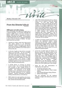
Document - Newsletter, Miners Write: Ballarat School of Mines Staff Newsletter, 1994-1997, 1994-1997
The Ballarat School of Mines is a predecessor institution of Federation University Australia. Photocopied newsletters with numerous newspaper clippings. 20 June 1994 - Mission, Women's Policy, Kate Wait, Walter Haller, Stewart Moors, Cynthia Jardine, Mark Lynch, R.J. Young Scholarship, David Thomas 22 August 1994 - Wimmera Community College Agreement, SMB/University of Ballarat Affiliation Agreement Signed by Chancellor Geoffrey Blainey, Max Palmer, Matthew Barlow, Mark Dawe, Phillip Lee, John Conaughton, Elizabeth White 05 September 1994 - Employment White Paper, Workcover, Ross Furness, Nance Jeffreys, Keith Chase, Michael Ronaldson, Ron Wild, Paul Jenkins 25 October 1994 - Staff Consultation Committee, Bendix Mintex Award, Rick Williams, Mike Hickey, Sexual Harassment, Ann McCaffrey, Brewery Complex building 07 November 1994 - Karpin Report, Edgar Bartrop Scholarship, Winsome McCaughey 13 June 1995 - Female Participation in TAFE, Lake Bolac Visit, Virginia Fenelon, Hairdressing, Ararat Community College, Brian MCLennan, Forestry Industry Contract, Ararat PRison Education, E.J.T. Tippett Award, Shane Lake, SMB Graduates 1995, Tony Leonard, Colin McCurry, Steph Pilmore 26 June 1995 - Child Care Centre, computer survey responses, Ellimatta, Sharna Whitehand, Jack Veeken, John Hanmer, Aaron Block, Kirsten Martin, Rowena Worth, Jan Croggon, Andrew McEvoy 24 July 1995 - Teaching, Engineering Liaison, Graham Shearer, Carol Durant, Brian McLennan, Market Research, Ararat Campus, Kevin Martin, Myrtle Muir, Hairdressing, Carol McDonald 07 August 1995 - Childcare, Playgroup, Disabilities, Judy Mills, Former Ballarat Gaol, Private Providers, Equal Opportunity, Equal Employment Opportunity 04 September 1995 - Keith Boast, Barkly Street Campus Library, Barrie Firth, Yuille Street Building, Painting and Decorating, Bricklaying, Disability Forum Committee, Belinda Morgan, Fay Guinane, Olivia Guinane, Robert Clarke Community Centre ceramic Tile Mosaic, Neville French, Annelies Egan, Judith Davies, Tanis Yuille, Margaret Komishon, Ruth Zegir, Ray Isaac 18 September - Competition Policy, Public Sector Reform, Brewery Building contract to S.J. Weir, Ararat Campus, BHP, Peter Bell, Mining Industry, Horticulture Facility (Gillies Street), Creche Fairy Mural, Shellagh Kentish, Daylesford Neighbourhood House and Learning Centre, Jenny Beacham, Tom Bates, Colin Trembath, Alan Scanosio, Zaiga Svanosio 16 October 1995 - Rural Studies Staffing, Robyn Greig, Ross Holton, Virginia Fenelon, Michelle Loader, Christina Elshaug, Cynthia Jardine, Morgan B. John death, Ian Pym, Melissa Cameron, hairdressing, Woolshed, Great Southern Woolshed, Graham Shearer October 1995 - Employment Relations Update, Enterprise Bargaining, Sue Wright, Ron Wild 30 October 1995 - 125th anniversary, 125th anniversary Medallions, Bill Murray (died 28 October 1995), Metal Fabrication, Ron Wild, Gael Ramsay, Paul Keating 20 November 1995 - Ceramics Exhibition, Heather Campbell, Marion Byass, Barry Norman, Helen Knowles, Michael Bracher, Brian McLennan, Rural Studies, Carpark, David Nicholson, Linetter Penhall, Suzanne Brown, Marie Bedggood 27 May 1996 - David Brown Farewell, Keith Boast, Educational Services, Wally Gradkowski, Dzintra Crocker, World Wide Web, Ann McCaffrey 17 June 1996 - Lifelong Learning Through Vocational Education and Training, Lyndal Cooper, Engineering Studies, David Manterfield, Rod MacKinney 19 August 1996 - SMB Strategic Plan 1997-2001, Ian Harris, Ararat Prison Education, Moongate 06 September 1996 - Tom Johnson, Bill Gribble, Ron Wild, INternational Projects Report, Cas Anderson, Court House Theatre, Former Court House, The Moongate 11 November 1996 - Brewery Complex Opening by Prime Minister John Howard on 09 December 1996, Human Resources, Marie Kerr, Fran Kisler, Karen Neale, Trudy Horwoood, Graham Hankin, Engineering Studies, David Manerfied, Sheilagh Kentish, Goroke College 12 May 1997 - Ballarat Group Training, Ballarat Aboriginal Co-operative, SMB Flexible Learning Centre, E.J. Tippett Library, Changing Role of the TAFE Teacher, Maree Greig, Colin Prowse, Performing Arts, Dave Knowles, Karyn Kilroy 20 August 1997 - Amalgamation Update, Graham Paynter, Heather MacLeod, Performing Arts 05 September 1997 - From TAFE to VET, Leoda Atkinson, Daniel James, Ararat campus, Mark Bevelander, computers, Craftsmanship Awards, Koorie Programs Unit, Deanne Jakiel, Stephen Burns, Women's Access Program, Internet 20 October 1997 - amalgamation update, Flexible Learning Centre, Andrea Bateman, Val D'Angri, Leoda Atkinson, Paul Mason, Andrea Bateman 10 November 1997 - Ballarat School of Mines/University of Ballarat Amalgamation, Shenzhen Polytechnic China, Videoconferencing, John Ferrier (Science), Performing Arts 08 December 1997 - Last Edition of Miners' Write Ron Wild, Brian McLennan, Max Palmer, Jeanetter John, Farewell to SMB, Time Capsuleminers write, ballarat school of mines, ron wild -
 Flagstaff Hill Maritime Museum and Village
Document - Plans, Lighthouse Keeper's Quarters Warrnambool, 1858-1909
The set of seven 1858 plans shows proposed plans for the original Lighthouse Complex that was built on Middle Island in 1858-1859. The whole complex was then transferred to Flagstaff Hill in 1871. The plan, dated 1909, is for proposed additions and repairs to the Quarters at Flagstaff Hill. The plan 'Alterations and Additions' shows alternate plans for changes to the quarters at the Flagstaff Hill location. This plan has no date. The Complex comprised the Lighthouse, the Lighthouse Keepers’ Quarters, the Store (now called the Chart Room) and a Privy, which was not included in these plans. The Keeper’s bluestone Quarters was a cottage divided into two compartments, one for each keeper and his family. The bluestone Store was divided into three; a store, a workshop an oil store (or office). The Privy comprised of a small building also divided into two separate, back-to-back toilets, one for each Keeper and his family. The Flagstaff Hill Keeper's Quarters have had extensions and additions at various times, and these have also been removed at various other times. THE PLANS - *Dec. 1858 (12/58) ‘Lighthouse Keepers Quarters No.2 Warrnambool’ (2375.01)* Public Works Office Melbourne – Front and Back elevations, sections, and floor plan. The drawing shows timber walls. [The floor plan is the closest plan to the current building, however, the walls are timber in this plan.] *Nov. 1858 – No.3 ‘Lighthouse Keepers Quarters Warrnambool’ (2375.02)* Office of Public Works, Melbourne – Back and End elevations and section through. The drawing shows stone walls. One side; Senior Keeper’s bedroom, living room and kitchen with storeroom. Another side; is the Assistant’s bedroom, living room and storeroom. *Nov. 1858 - No.4 ‘Lighthouse Stores Warrnambool’ (2375.03)* Office of Public Works – Front, Side and end elevations, centre section. The drawing shows stone walls. *Nov. 1858 – No.4, ‘Lighthouse Stores No. 2 Warrnambool’ (2375.04)* Office of Public Works – Front, side and end elevations, centre section. The drawing shows timber walls. *Nov. 1858 – ‘Details Lighthouse Keepers Quarters No. 2 Warrnambool’ (2375.05)* Public Works Office Melbourne. The plan shows the foundations, joists and eaves. The drawing shows timber walls. (Nov. 1858 – ‘No.4 ‘Lighthouse No. 2 – Warrnambool’ (2375.06)* Public Works Melbourne (Part of the paper is missing). This plan shows an octagonal tower, internal stairs, a balcony landing, and a weather vane on top. *November 1858 – No. 1, ‘Lighthouse – Warrnambool’ (2375.07)* Office of Public Works Melbourne. This plan shows a round tower, including the stairs, windows on the tower and the weather vane on the top. *4/3/9 [1909] – ‘Additions and Repairs, Lighthouse Quarters, Warrnambool, General Plan’ (2375.8)* Department of Public Works Melbourne’s official stamp is signed by Croft. It shows the floor plans of the Store, Upper Lighthouse and the Quarters. The Store building has three sections; a Store, Work-Shop and Office, with an internal wall between them and separate entries. The Quarters are divided into two dwellings. The Senior Keeper’s side on the left has fireplaces in two of the three bedrooms and there is a pantry and wash house. The Assistant’s side has no fireplaces in the bedrooms and there’s no pantry or washhouse. These plans include proposed changes to the buildings. The Senior Keeper’s Quarters would have a partition on bedroom 2, a bath with plumbing and drainage, a wall moved and a built-in side porch. The Store would also have a built-in porch. The undated plan 'Additions and Alterations' (2375.9) shows alternative arrangements for water tanks, plumbing and such. WARRNAMBOOL'S LADY BAY LIGHTHOUSES- In the 1800s ships sailing from England to Australia began to use Bass Strait as a faster route to Melbourne. Small navigation errors led to many tragic shipwrecks. From 1848 lighthouses were operating along Victoria’s southern coast as a guide for sailors. Coastal towns such as Warrnambool grew and the exchange of trade and passengers were of great benefit. However, the uncertain weather changes, relatively shallow waters and treacherous, hidden rocky reefs were not suitable for a Harbour and in the 1840s and 1850s there were many shipwrecks in the area, with some even stranded in its Lady Bay harbour. A jetty was built in 1850 and a flagstaff to guide seafarers was placed up high on what became known now as Flagstaff Hill. In November 1857 the Victorian Government recommended that Warrnambool Harbour had beacons and two lighthouses to guide vessels into and out of the Harbour safely. The white light of the Middle Island lighthouse was to be used for the first time on September 1, 1859. The red light of the Beach Lighthouse, a wooden obelisk structure, was first operated on March 25, 1860, but in 1868 this light was ‘discontinued’ due to it being too low. Melbourne’s Department of Public Works decided to relocate the Middle Island Lighthouse Complex - Lighthouse, Keeper’s Quarters, Privy, Store Room and even water tanks - to Flagstaff Hill. The lower obelisk was shortened, and a protruding gallery, railing, and external ladder were added, as well as the light from the Beach Lighthouse. A green guiding light was erected on the end of the jetty. The transfer of the Complex began in March 1871. Each shaped stone of the lighthouse was carefully numbered, removed then reassembled on Flagstaff Hill. In 1872 the well was sunk behind the Lighthouse Keeper’s Cottage. The Keepers and families had left Middle Island in April and moved to Flagstaff Hill in October 1871. Vessels entering Lady Bay align the Upper and Lower Lighthouse towers during the day and the lights at night. The Upper Lighthouse is a round tower, the Lower Light is square. The Lighthouses were categorised as harbour lights rather than coastal lights, so they remain under the control of the Victorian Government’s Ports and Harbours section. The lights were originally powered by oil, then acetylene gas, later by electricity, and then converted to solar power in 1988. In 1993 the solar panel was replaced by a battery charger. A decision was made in 1936 to replace the lighthouses’ lights with unattended lights that no longer required Keepers and Assistants. At least 29 Keepers had attended to the lighthouse from its opening in 1859 to when the last official Lightkeepers left In April 1916. The Warrnambool Harbour Board rented out the Quarters from 1916 to 1936. The Board closed down but the rentals continued with other unknown landlords. In the 1970s the Flagstaff Hill Planning Board was set up under the chairmanship of John Lindsay. The Board was to make recommendations to the Warrnambool City Council regarding the use of the buildings and the rest of the Crown Land on the site. The Flagstaff Hill Maritime Village opened in 1975 and began renovating the Cottage in stages, during which time evidence of a 1920s fire was found in the eastern section of the cottage. Additions of a porch on the west and a washroom on the east were made in the 1980s. The western part of the building is now a Shipwreck Museum and the east has returned to a late 19th-century Lighthouse Keeper’s cottage and includes the screen made by Assistant Lighthouse Keeper Thomas Hope during one of his two periods of service there. THE LIGHTHOUSE KEEPERS Lighthouse Keepers were responsible for keeping their Lighthouse’s lights shining at night. They kept a lookout for passing vessels and changes in weather. They were expected to clean, polish and maintain the equipment and buildings. They kept regular and detailed records of who was on watch, and the time the light was lit, trimmed and extinguished. They kept a journal about other events that occurred. They keep regular, accurate Meteorological Logs. It was expected that they were competent in Morse code signalling. They would be called to help in times of disasters and shipwrecks, and to give official statements about these events. Many Lighthouse Keepers also volunteered as members of the lifeboat crew. The Lady Bay lighthouses were officially classified as small, so the Keepers had the official titles of Senior Assistant Lighthouse Keeper and Assistant Lighthouse Keeper. They were employed by the Public Service and paid rent to live in the Lighthouse Quarters. They were compulsorily retired at the age of 60, with most receiving a superannuation payment. Despite their time-consuming duties, there was time to follow hobbies and crafts such as growing vegetables, playing musical instruments, making models of buildings including lighthouses, and crafting furniture pieces. An example of a keeper’s skills is the carved fire screen made by /assistant Keeper Thomas Hope in the early 20th century and displayed in the Lighthouse Keeper’s cottage at Flagstaff Hill. The last occupants of the Middle Island Complex were Senior Keeper Robert Deverell, his Assistant Keeper, Andrew Farncombe, and their families. They all became the first occupants at the Lady Bay Lighthouse Keepers’ Quarters on Merri Street. The Warrnambool Lighthouse Complex plans are the origin of what is now the Lady Bay Lighthouse Complex. They are a record of the people, process and departments involved in bringing the complex into fruition. The plans are significant to the Complex, which is now listed on the Victorian Heritage Register, H1520, for being of historical, scientific (technological) and architectural significance to the State of Victoria. The Complex is significant as an example of early colonial development. The plan are significant for their connection with the important navigational function of the Lighthouses, a function still being performed to this day. The plans are also significant as an example of a product from the Public Works Department in Victoria in the mid-to-late 19th century. The structures built to these plans still stand strong. Plans for the Lighthouse Complex in Warrnambool, including Lighthouses, Keeper's Quarters and Stores. Seven of the plans are on thin fragile paper, one is on thicker, stronger paper. The drawings have been made in pens coloured red and black. They originate from Public Works in Melbourne. Seven were drawn in 1858, one in 1904, the other is not dated.Dec. 1858 - Lighthouse Keepers Quarters No.2 Warrnambool. Public Works Office Melbourne. Nov. 1858 - No.3 ‘Lighthouse Keepers Quarters Warrnambool. Public Works Office Melbourne. Nov. 1858 - No.4 ‘Lighthouse Stores Warrnambool. Office of Public Works. Nov. 1858 - No.4, ‘Lighthouse Stores No. 2 Warrnambool. Office of Public Works. Nov. 1858 - Details Lighthouse Keepers Quarters No. 2 Warrnambool. Public Works Office Melbourne. Nov. 1858 - No.4 ‘Lighthouse No. 2 – Warrnambool. Public Works Melbourne. Nov. 1858 - No. 1, Lighthouse - Warrnambool. Office of Public Works Melbourne. 4/3/9 [1909] - Additions and Repairs, Lighthouse Quarters, Warrnambool, General Plan. Department of Public Works Melbourne. SIGNED "Croft" "15A" on reverse [no date] - Lighthouse Quarters Warrnambool, Additions and Alterations. "9A" on reverseflagstaff hill, warrnambool, lighthouse keeper's cottage, lighthouse residence, lighthouse, plans, public works, melbourne, flagstaff hill maritime museum, maritime museum, shipwreck coast, flagstaff hill maritime village, chart room, quarters, privy, middle island, beach lighthouse, obelisk, lighthouse keeper, assistant keeper, lighthouse complex, lady bay, lady bay complex, keepers, upper lighthouse, lower lighthouse, ports and harbours, cottage, harbour board, flagstaff hill planning board, meteorological record, robert deverell, andrew farncombe, warrnambool port, warrnambool harbour, residence, alterations, repairs, department of works -
Glenelg Shire Council Cultural Collection
Photograph - Photograph - Portland Harbour Development, n.d
Port of Portland Authority ArchivesFront: Black & white Photograph of a plan showing proposed changes to the Fisherman's Breakwater area of the Port of Portlandport of portland archives, port of portland -
Bendigo Historical Society Inc.
Document - NATIONAL TRUST COLLECTION: CAMPBELL AND CONNOLLY BUILDING, 1986
Campbell and Connolly Building Appeal heard on 5/2/1986 Black and white photo Floor plan Plan of proposed shop renovation Letter to Mr John Hogan from Laurie Wilson re appeal Bendigo Advertiser article 6/2/1986 re change to building Collection of letters and forms relating to the appeal. Appeal concerns were the erection of verandah replacement and replacement of existing windows and doors.bendigo, buildings -
 Kew Historical Society Inc
Plan, Borough of Kew Detail Plan No.1577, 1904
The Melbourne and Metropolitan Board of Works (MMBW) plans were produced from the 1890s to the 1950s. They were crucial to the design and development of Melbourne's sewerage and drainage system. The plans, at a scale of 40 feet to 1 inch (1:480), provide a detailed historical record of Melbourne streetscapes and environmental features. Each plan covers one or two street blocks (roughly six streets), showing details of buildings, including garden layouts and ownership boundaries, and features such as laneways, drains, bridges, parks, municipal boundaries and other prominent landmarks as they existed at the time each plan was produced. (Source: State Library of Victoria)This plan forms part of a large group of MMBW plans and maps that was donated to the Society by the Mr Poulter, City Engineer of the City of Kew in 1989. Within this collection, thirty-five hand-coloured plans, backed with linen, are of statewide significance as they include annotations that provide details of construction materials used in buildings in the first decade of the 20th century as well as additional information about land ownership and usage. The copies in the Public Record Office Victoria and the State Library of Victoria are monochrome versions which do not denote building materials so that the maps in this collection are invaluable and unique tools for researchers and heritage consultants. A number of the plans are not held in the collection of the State Library of Victoria so they have the additional attribute of rarity.Original survey plan, issued by the MMBW to a contractor with responsibility for constructing sewers in the area identified on the plan within the Borough of Kew. The plan was at some stage hand-coloured, possibly by the contractor, but more likely by officers working in the Engineering Department of the Borough and later Town, then City of Kew. The hand-coloured sections of buildings on the plan were used to denote masonry or brick constructions (pink), weatherboard constructions (yellow), and public buildings (grey). MMBW Plan No.1577 includes some of the most significant houses in Kew: Herbert Henty’s ‘Roxeth’ (now part of Trinity Grammar), ‘Butleigh Wooton’, ‘Bokara’ and ‘Harrow’. It also includes the streets that have since changed their names. That part of College Parade linked to Glenferrie Road is now named College Place, College Parade now extends further north, and Charles Street did not yet reach Barkers Road. Roxeth is one of a number of Henty houses in Kew. Herbert Henty made his home here and was elected a member of Kew Municipal Council in 1864 and mayor in 1868-69. Walter Henry Serle, of Harrow served in the First World War. He was awarded the Military Medal ‘’For conspicuous bravery and devotion to duty. On 29th September near BELLICOURT he showed the greatest bravery and determination when his platoon was attacked by enemy bombing parties. It was due largely to his personal efforts that all the attacks were repulsed. Until wounded, his utter disregard of personal safety and boldness in dealing with the attacks were the means of saving the situation and were an inspiring example to his men.’melbourne and metropolitan board of works, detail plans, maps - borough of kew, mmbw 1577, cartography -
 Kew Historical Society Inc
Plan, Melbourne and Metropolitan Board of Works, Borough of Kew : Detail Plan No.1580, 1904
The Melbourne and Metropolitan Board of Works (MMBW) plans were produced from the 1890s to the 1950s. They were crucial to the design and development of Melbourne's sewerage and drainage system. The plans, at a scale of 40 feet to 1 inch (1:480), provide a detailed historical record of Melbourne streetscapes and environmental features. Each plan covers one or two street blocks (roughly six streets), showing details of buildings, including garden layouts and ownership boundaries, and features such as laneways, drains, bridges, parks, municipal boundaries and other prominent landmarks as they existed at the time each plan was produced. (Source: State Library of Victoria)This plan forms part of a large group of MMBW plans and maps that was donated to the Society by the Mr Poulter, City Engineer of the City of Kew in 1989. Within this collection, thirty-five hand-coloured plans, backed with linen, are of statewide significance as they include annotations that provide details of construction materials used in buildings in the first decade of the 20th century as well as additional information about land ownership and usage. The copies in the Public Record Office Victoria and the State Library of Victoria are monochrome versions which do not denote building materials so that the maps in this collection are invaluable and unique tools for researchers and heritage consultants. A number of the plans are not held in the collection of the State Library of Victoria so they have the additional attribute of rarity.Original survey plan, issued by the MMBW to a contractor with responsibility for constructing sewers in the area identified on the plan within the Borough of Kew. The plan was at some stage hand-coloured, possibly by the contractor, but more likely by officers working in the Engineering Department of the Borough and later Town, then City of Kew. The hand-coloured sections of buildings on the plan were used to denote masonry or brick constructions (pink), weatherboard constructions (yellow), and public buildings (grey). The area represented in this detail plan has undergone significant change during the 20th century. The widening of High Street in the 1930s and 1950s involved the shops on the south side of High Street being demolished and later rebuilt to fit the widened street. Another significant loss was the mansion ‘Drayton’ fronting Wellington Street, owned at this stage by Susannah Fenton. Her family name would later to be given to Fenton Way, which was to be built over the grounds of the house following its demolition. The plan of the garden is particularly interesting, containing a batten dome fronting Wellington Street, an ornamental pond, a fountain and a brick and glass conservatory. The notes by the plumbing contractor on this plan are particularly detailed. Pink borders delineate the ownership of the varying parcels of land. Some of the better known owners listed include the real estate agent Cr. Henry de Castres Kellett (bt) and John Padbury, the funeral director. This particular plan provides a clear view of the configuration of the Kew Junction in 1903 and the commercial buildings that surrounded it.melbourne and metropolitan board of works, detail plans, maps - borough of kew, mmbw 1580, cartography -
Kew Historical Society Inc
Journal, Kewriosity : June 1991
Re locations [North Kew Tennis Club, 1st Kew Scouts] / 1. North's replacement kinder [Kew Preschool Association and North Kew Kindergarten in Pakington Street] / p1. Kinders - What to do? [Council finances] / p1. Junction Traffic Study / p1. Diary dates for June / p2. Bravo, Band! [Kew Youth Band, Kew Band] / p2. World's best animation [3 MBS fundraising] / p2. Travelling friends [St Anthony's Children's Home reunion] / p2. Commentary [Council budget] / Cr Daryl Oldaker p3. Chief Executive's Column [corporate structure] / Malcolm Hutchinson p3. Beat the beetle [elm leaf beetle] / p4. One electorate: six winners [Hare Clark system] / p4. Heritage Planning [Heritage Residential Zone and individual building controls] / p4. Vale - Allan Hutchinson J.P. 1938-1991 [obituary] / p4. Kewriosity lives on / p5. Nappies in Walpole Street [baby change room] / p6. St George's not dragg'n its feet [Three Year Accreditation Certificate] / p6. Get a dog ... But register it / p6. Sisters kick up heels [Our Lady of Missions dance] / p6. Davis Street's open day [Davis Street Kindergarten] / p7. Baby, Look at us now [High Street Kindergarten] / p6. [Fourth Kew] Scouts host Chernobyl children / p6. New threesome [Trio Nova] / p7. A good get-together [Kew Community House] / p7. A certain timbre [furniture design] / 7. Pride on wheels / p7. Keeping home fires burning [Dunnings Wood Yard] / p7. 1938 diarists / p8. Carey picnic / p8. Henry VIII Birthday / p8. Walk the Outer Circle [walking tours by Australian Railway Historical Society] / p8.Kewriosity was a local newsletter combining Kew Council and community news. It was published between November 1983 and June 1994, replacing an earlier Kewriosity [broad] Sheet (1979-84). In producing Kewriosity, Council aimed to provide a range of interesting and informative articles covering its deliberations and decision making, together with items of general interest and importance to the Kew community and information not generally available through daily media outlets.non-fictionRe locations [North Kew Tennis Club, 1st Kew Scouts] / 1. North's replacement kinder [Kew Preschool Association and North Kew Kindergarten in Pakington Street] / p1. Kinders - What to do? [Council finances] / p1. Junction Traffic Study / p1. Diary dates for June / p2. Bravo, Band! [Kew Youth Band, Kew Band] / p2. World's best animation [3 MBS fundraising] / p2. Travelling friends [St Anthony's Children's Home reunion] / p2. Commentary [Council budget] / Cr Daryl Oldaker p3. Chief Executive's Column [corporate structure] / Malcolm Hutchinson p3. Beat the beetle [elm leaf beetle] / p4. One electorate: six winners [Hare Clark system] / p4. Heritage Planning [Heritage Residential Zone and individual building controls] / p4. Vale - Allan Hutchinson J.P. 1938-1991 [obituary] / p4. Kewriosity lives on / p5. Nappies in Walpole Street [baby change room] / p6. St George's not dragg'n its feet [Three Year Accreditation Certificate] / p6. Get a dog ... But register it / p6. Sisters kick up heels [Our Lady of Missions dance] / p6. Davis Street's open day [Davis Street Kindergarten] / p7. Baby, Look at us now [High Street Kindergarten] / p6. [Fourth Kew] Scouts host Chernobyl children / p6. New threesome [Trio Nova] / p7. A good get-together [Kew Community House] / p7. A certain timbre [furniture design] / 7. Pride on wheels / p7. Keeping home fires burning [Dunnings Wood Yard] / p7. 1938 diarists / p8. Carey picnic / p8. Henry VIII Birthday / p8. Walk the Outer Circle [walking tours by Australian Railway Historical Society] / p8. publications -- city of kew (vic.), kewriosity, council newsletters, community newsletters -
Kew Historical Society Inc
Journal, Kewriosity : August 1989
Cricket with a difference [Kooyong Cricket Club, St Paul's School] / p1. No election for Kew / p1. Dates for August / p2. Changes to baby capsule loan scheme / p2. Council seeks comments on Area 7 Traffic Plan [Studley Park] / p2. Council to monitor Government policy on Kew Cottages Plan [deinstitutionalisation] / p3. Walpole Hill parking / p3. Fire and incinerator by-law under review / p3. Notices / p4. Local office gives tenants information [Inner Eastern Housing and Tenants' Information Service] / p4. New two-year-old session of occasional care [Kew Occasional Care Centre] / p4. Help for people with head injuries / p4. Free advice to home and business owners [Heritage Advisory Service] / p4. Images of Melbourne on local view [Ian Napier, Raya Gallery] / p5. "Sharps" Disposal Scheme planned for Kew / p5. Flowers from Friends of Bodalla / p5. Kew Community House / p6. Write about life / p6. Council supports free public libraries / p6. Senior Citizens' Week 1990 / p7. Extra school crossing supervisors for Kew / p7. Give blood for life / p7. Council may vaccinate "staff at risk" [Hepatitis B] / p7. Asbestos scheduled for removal from Council Offices / p7. Neighbourhood Watch / p8. Greenfingers change venue [Kew Garden Club] / p8. New production of The Lilac Domino [Viola Music Society] / p8. Why not croquet? [Kew Croquet Club] / p8. Footy News [Kew Football Club] / p8. Greenlink Kew / p8.Kewriosity was a local newsletter combining Kew Council and community news. It was published between November 1983 and June 1994, replacing an earlier Kewriosity [broad] Sheet (1979-84). In producing Kewriosity, Council aimed to provide a range of interesting and informative articles covering its deliberations and decision making, together with items of general interest and importance to the Kew community and information not generally available through daily media outlets.non-fictionCricket with a difference [Kooyong Cricket Club, St Paul's School] / p1. No election for Kew / p1. Dates for August / p2. Changes to baby capsule loan scheme / p2. Council seeks comments on Area 7 Traffic Plan [Studley Park] / p2. Council to monitor Government policy on Kew Cottages Plan [deinstitutionalisation] / p3. Walpole Hill parking / p3. Fire and incinerator by-law under review / p3. Notices / p4. Local office gives tenants information [Inner Eastern Housing and Tenants' Information Service] / p4. New two-year-old session of occasional care [Kew Occasional Care Centre] / p4. Help for people with head injuries / p4. Free advice to home and business owners [Heritage Advisory Service] / p4. Images of Melbourne on local view [Ian Napier, Raya Gallery] / p5. "Sharps" Disposal Scheme planned for Kew / p5. Flowers from Friends of Bodalla / p5. Kew Community House / p6. Write about life / p6. Council supports free public libraries / p6. Senior Citizens' Week 1990 / p7. Extra school crossing supervisors for Kew / p7. Give blood for life / p7. Council may vaccinate "staff at risk" [Hepatitis B] / p7. Asbestos scheduled for removal from Council Offices / p7. Neighbourhood Watch / p8. Greenfingers change venue [Kew Garden Club] / p8. New production of The Lilac Domino [Viola Music Society] / p8. Why not croquet? [Kew Croquet Club] / p8. Footy News [Kew Football Club] / p8. Greenlink Kew / p8. publications -- city of kew (vic.), kewriosity, council newsletters, community newsletters -
Kew Historical Society Inc
Journal, Kewriosity : May 1986
Villa Alba opens its doors / p1&5. Put this bottles out / p1. Calling all clubs / p1. Dates for May / p2. [Community] Notices / p2. Wanted: Home based child care workers (Full time and Part Time) [Hawthorn/Kew Family Day Care] / p2. Commentary by the Mayor Councillor Phyllis Hore [Kew and Local Government Restructure] / Cr Phyllis Hore p3. New faces at the Occasional Care Centre [Margaret Farnfield] / p3. Traffic Management / p3. In Brief [Kew Library re-location; Changes to planning scheme in Kew Junction?; Restructure; Consultants for Heritage Study; Rec. Centre] / p4. Profile - Cr Noel Seletto / p4-5. Good gardening - Don't burn those leaves! / Peter Davies p5. Holiday Program / p5. Kew Community House / Rhonda McCaw p6. In praise of Kew [poems] / Sophie Dougall / p6. Elysium Ensemble in Kew / p6. Keeping you informed [Citizens' Advice Bureau] / p6. Kew High: a student centred school / p7. Ramblings of Kew's last cowboy - Part 2 of a series by Bill Stent [dairy farms] / Bill Stent p8. Letter - Pink Monster ['The Grip of Time'] / Barbara Giles p8. Footy news [Kew Football Club] / p8.Kewriosity was a local newsletter combining Kew Council and community news. It was published between November 1983 and June 1994, replacing an earlier Kewriosity [broad] Sheet (1979-84). In producing Kewriosity, Council aimed to provide a range of interesting and informative articles covering its deliberations and decision making, together with items of general interest and importance to the Kew community and information not generally available through daily media outlets.non-fictionVilla Alba opens its doors / p1&5. Put this bottles out / p1. Calling all clubs / p1. Dates for May / p2. [Community] Notices / p2. Wanted: Home based child care workers (Full time and Part Time) [Hawthorn/Kew Family Day Care] / p2. Commentary by the Mayor Councillor Phyllis Hore [Kew and Local Government Restructure] / Cr Phyllis Hore p3. New faces at the Occasional Care Centre [Margaret Farnfield] / p3. Traffic Management / p3. In Brief [Kew Library re-location; Changes to planning scheme in Kew Junction?; Restructure; Consultants for Heritage Study; Rec. Centre] / p4. Profile - Cr Noel Seletto / p4-5. Good gardening - Don't burn those leaves! / Peter Davies p5. Holiday Program / p5. Kew Community House / Rhonda McCaw p6. In praise of Kew [poems] / Sophie Dougall / p6. Elysium Ensemble in Kew / p6. Keeping you informed [Citizens' Advice Bureau] / p6. Kew High: a student centred school / p7. Ramblings of Kew's last cowboy - Part 2 of a series by Bill Stent [dairy farms] / Bill Stent p8. Letter - Pink Monster ['The Grip of Time'] / Barbara Giles p8. Footy news [Kew Football Club] / p8. publications -- city of kew (vic.), kewriosity, council newsletters, community newsletters -
Kew Historical Society Inc
Journal, The Kewriosity Sheet Vol.4 No.11 : July 1983
Art exhibition: Trinity Grammar School / p1. A new Musical at St Hilary's Kew ('Rocky & the Bloke' / p1. Visitors welcome (Rheumatism and Arthritis Association of Victoria) / p1. Uniting Church Congregational Casserole Dinner / p2. 1st Kew Scout Group bottle recycling depot change / p2. Native Plant Group / p2. Save the Children Fund / p2. Kew Citizens' Advice Bureau / p2. Kew Historical Society / p2. Kew Library (displays) / p2. Billabong Club for boys and girls primary school age (Kew Baptist Church) / p2. Th treasures of our city (Villa Alba; Historic houses; Heritage planning; Louis Kahan - Kew Synagogue windows) / p3. C.A.B. volunteers need (Citizens' Advice Bureau) / p3. Daytime Garden Club / p3. East Kew Uniting Church (calendar of events) / p4. Kew Garden Club / p4. Evening Mission Group (Kew Uniting Church) / p4. Hyde Park Fellowship (Hyde Park Uniting Church) / p4. 'Rotaract Rave' / p4. Scrabble / p4.The Kewriosity Sheet (1979-83) was first published in the City of Kew (Victoria) in June 1979 as a two-sided 'community newssheet'. It aimed to: 'share news about Kew happenings and Kew people, and to exchange ideas about living in Kew'. Later issues gradually evolved into a 4-page, quarto sized publication. The Kewriosity Sheet was superseded by the Kew Council publication 'Kewriosity' (1983-1994).non-fictionArt exhibition: Trinity Grammar School / p1. A new Musical at St Hilary's Kew ('Rocky & the Bloke' / p1. Visitors welcome (Rheumatism and Arthritis Association of Victoria) / p1. Uniting Church Congregational Casserole Dinner / p2. 1st Kew Scout Group bottle recycling depot change / p2. Native Plant Group / p2. Save the Children Fund / p2. Kew Citizens' Advice Bureau / p2. Kew Historical Society / p2. Kew Library (displays) / p2. Billabong Club for boys and girls primary school age (Kew Baptist Church) / p2. Th treasures of our city (Villa Alba; Historic houses; Heritage planning; Louis Kahan - Kew Synagogue windows) / p3. C.A.B. volunteers need (Citizens' Advice Bureau) / p3. Daytime Garden Club / p3. East Kew Uniting Church (calendar of events) / p4. Kew Garden Club / p4. Evening Mission Group (Kew Uniting Church) / p4. Hyde Park Fellowship (Hyde Park Uniting Church) / p4. 'Rotaract Rave' / p4. Scrabble / p4. community publications --- kew (vic.), the kewriosity sheet, newsletters - kew (vic.) -
 Kew Historical Society Inc
Plan - Subdivision Plan, Lodged Plan No.6518, 1920-1940
The Kew Historical Society collection includes almost 100 subdivision plans pertaining to suburbs of the City of Melbourne. Most of these are of Kew, Kew East or Studley Park, although a smaller number are plans of Camberwell, Deepdene, Balwyn and Hawthorn. It is believed that the majority of the plans were gifted to the Society by persons connected with the real estate firm - J. R. Mathers and McMillan, 136 Cotham Road, Kew. The Plans in the collection are rarely in pristine form, being working plans on which the agent would write notes and record lots sold and the prices of these. The subdivision plans are historically significant examples of the growth of urban Melbourne from the beginning of the 20th Century up until the 1980s. A number of the plans are double-sided and often include a photograph on the reverse. Reconciling this hand-drawn subdivision plan with a modern map of the area is initially a challenge due to a change of street names. Argyle Road in the centre of the subdivision was to be renamed Deepdene Road, and the street named Deepdene Road on the plan was to become Deepdene Place. Of interest is the nursery on the corner of Argyle and Whitehorse Roads. During this period there were a number of nurseries servicing the Kew and Balwyn areas. The subdivision was essentially of the land formerly occupied by the house 'Deepdene'.subdivision plans - balwyn, deepdene, whitehorse road -- deepdene (vic.), deepdene road -- deepdene (vic.), burke road -- deepdene (vic.) -
 Kew Historical Society Inc
Plan - Subdivision Plan, J R Mathers & McMillan, Clutha Subdivision, 1940
Pru Sanderson, in her groundbreaking ‘City of Kew Urban Conservation Study : Volume 2 - Development History’ (1988), summarised the periods of urban development and subdivisions of land in Kew. The periods that she identified included 1845-1880, 1880-1893, 1893-1921, 1921-1933, 1933-1943, and Post-War Development. These periods were selected as they represented periods of rapid growth or decline in urban development. An obvious starting point for Sanderson’s groupings involved population growth and the associated economic cycles. These cycles also highlighted urban expansion onto land that was predominantly rural, although in other cases it represented the decline and breakup of large estates. A number of the plans in the Kew Historical Society’s collection can also be found in other collections, such as those of the State Library of Victoria and the Boroondara Library Service. A number are however unique to the collection.The Kew Historical Society collection includes almost 100 subdivision plans pertaining to suburbs of the City of Melbourne. Most of these are of Kew, Kew East or Studley Park, although a smaller number are plans of Camberwell, Deepdene, Balwyn and Hawthorn. It is believed that the majority of the plans were gifted to the Society by persons connected with the real estate firm - J. R. Mathers and McMillan, 136 Cotham Road, Kew. The Plans in the collection are rarely in pristine form, being working plans on which the agent would write notes and record lots sold and the prices of these. The subdivision plans are historically significant examples of the growth of urban Melbourne from the beginning of the 20th Century up until the 1980s. A number of the plans are double-sided and often include a photograph on the reverse. A number of the latter are by noted photographers such as J.E. Barnes.The subdivision plan for the Clutha Subdivision is one of the largest in the Society’s collection. The plan includes a map of the proposed allotments, photographic views to the north and south, and information about the kinds of buildings that could be constructed on the allotments. The subdivision was bounded by Studley Park Road, and Carson, Stevenson and Edgecombe Streets. Two new streets, Mackie Court and Younger Street were created as part of the subdivision. The subdivision took its name from ‘Clutha’, the home of John Carson, who was to become Mayor of Kew in 1863. A Report to the City of Boroondara outlined how: ‘The Clutha estate was progressively developed from 1940, with new houses under construction on the Studley Park Road, Carson and Edgecombe Street frontages by 1941. By 1943, directory listings were available for all addresses with the exception of Mackie Court. Building ceased after the government’s prohibition on civilian building was enforced from 1942, with little change in listings until the 1950s when the remainder of the subdivision was developed’."H"subdivisions - kew - studley park, clutha subdivision, studley park road -
 Kew Historical Society Inc
Plan, Melbourne & Metropolitan Board of Works : Borough of Kew : Detail Plan No.1574, 1905
The Melbourne and Metropolitan Board of Works (MMBW) plans were produced from the 1890s to the 1950s. They were crucial to the design and development of Melbourne's sewerage and drainage system. The plans, at a scale of 40 feet to 1 inch (1:480), provide a detailed historical record of Melbourne streetscapes and environmental features. Each plan covers one or two street blocks (roughly six streets), showing details of buildings, including garden layouts and ownership boundaries, and features such as laneways, drains, bridges, parks, municipal boundaries and other prominent landmarks as they existed at the time each plan was produced. (Source: State Library of Victoria)This plan forms part of a large group of MMBW plans and maps that was donated to the Society by the Mr Poulter, City Engineer of the City of Kew in 1989. Within this collection, thirty-five hand-coloured plans, backed with linen, are of statewide significance as they include annotations that provide details of construction materials used in buildings in the first decade of the 20th century as well as additional information about land ownership and usage. The copies in the Public Record Office Victoria and the State Library of Victoria are monochrome versions which do not denote building materials so that the maps in this collection are invaluable and unique tools for researchers and heritage consultants. A number of the plans are not held in the collection of the State Library of Victoria so they have the additional attribute of rarity.Original survey plan, issued by the MMBW to a contractor with responsibility for constructing sewers in the area identified on the plan within the Borough of Kew. The plan was at some stage hand-coloured, possibly by the contractor, but more likely by officers working in the Engineering Department of the Borough and later Town, then City of Kew. The hand-coloured sections of buildings on the plan were used to denote masonry or brick constructions (pink), weatherboard constructions (yellow), and public buildings (grey). This plan shows several very large houses, particularly along Glenferrie Road, and the area now occupied by Ruyton Girls’ School. ‘Tarring’ (incorrectly spelled here as ‘Karring’) was built for Henry Henty in 1872, on part of his original allotment of 20 acres, and ‘Mount View’, which retains its original building and the fountain in the front garden, is part of Ruyton’s Junior School. The most significant change to Tarring and its grounds since 1903, involve the removal of a number of the outbuildings, including a Burmese temple, bought by Henty from the Burmese Exhibit at the Great Exhibition of 1880. It is shown on the plan as a summerhouse. The two-storey mansion, on the corner of Glenferrie Road and Wellington Street, was built in 1891 by leading architect Alfred White as his own home. Having an initial N.A.V. of £160, the house was purchased by a warehouseman Henry Lister, by 1900, when the N.A.V. was recorded at £111. By the turn of the century the house was known as ‘Comaques’. By contrast, much smaller houses are shown in Scott and Byron Streets, including a tiny Mission Hall in Byron Street, which belonged to the Anglican Church from at least 1903 to 1917.melbourne and metropolitan board of works, detail plans, maps - borough of kew, mmbw 1574, cartography -
Canterbury History Group
Document - School Project: A history of 137 Mont Albert Road, Canterbury, Rush, Anne-Marie
A research paper for the Australian History option describing the history of 137 Mont Albert Road, Canterbury. The writer looks at the lives of various owners, particularly Henry Elgar and Richard Quittenton, and how the house has changed since it was built in 1890. includes 2 pages of plans of Elgar's Special Surveycanterbury, mont albert road, "haslemere", quittenton> richard, elgar> henry, elgar's special survey, boroondara estate -
 City of Kingston
Pamphlet - Black and white, Robert McCamish & John Gilpin (Vendors), For Private Sale Station Entrance Estate, Highett, 1930s
Sales plan for land in the suburb of Highett, bounded by Wickham Road, Railway Parade, Highett Road and Point Nepean Street. The developing urban area of Highett within the City of Kingston. This land sale pamphlet illustrates the subdivision of land within the municipality and the changing demographic of the district as new houses are constructed. The extension of the railway line from the city to Mordialloc opened up the land for development.Black and white pamphlet advertising for private sale the Station Entrance Estate, Highett. Incorporates a map of the estate bordered by Wickham Road, Railway Parade, Highett Road and Point Nepean Road. Handwritten in black ink on reverse: Station Entrance / Estate / Late [indecipherable]highett, land sales, estate -
 City of Kingston
Pamphlet - Colour, Stillwell and Co, The Hill Estate Highett Great Subdivisional Auction Sale, 1917
Sales plan for land in the suburb of Highett, bounded by Point Nepean Road and incorporating Sandford Street, Turner Road, Alfred Street, Peace Street and Tennyson Street. .The developing urban area of Highett within the City of Kingston. This land sale pamphlet illustrates the subdivision of land within the municipality and the changing demographic of the district as new houses are constructed.Colour pamphlet advertising subdivisional auction sale of the Hill Estate Highett. Incorporates a map of the estate bordered by Point Nepean Road and encompassing Sandford Street, Turner Road, Alfred Street, Peace Street and Tennyson St. Handwritten in grey pencil on reverse: Hill Street / Jamieson Handwritten in blue pencil on reverse: The Hill Estate Handwritten in blue pencil on subdivision map: [tick] [on majority of properties marked on map]highett, land sales, estate -
 City of Kingston
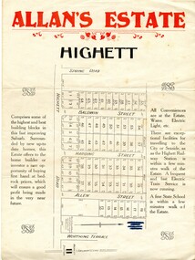
Pamphlet - Colour, Allan's Estate Highett, 1930s
Sales plan for land in the suburb of Highett, bounded by Spring Road, Highett Road and Worthing Terrace.The developing urban area of Highett within the City of Kingston. This land sale pamphlet illustrates the subdivision of land within the municipality and the changing demographic of the district as new houses are constructed.Colour pamphlet advertising Allan's Estate, Highett. Incorporates a map of the estate bordered by Spring Road, Highett Road and Worthing Terrace.Handwritten in grey pencil on reverse: Allan's Estate / Highett Crossed out in blue pencil on front: Name and address of what appears to be a solicitorhighett, land sales, estate -
 City of Kingston
Pamphlet - Colour, W. H. Wood Estate Agent, Subdivisional Land Auction Barker's Estate Cheltenham, 1919
Sales plan for land in the suburb of Cheltenham, along Barker StreetThe developing urban area of Cheltenham within the City of Kingston. This land sale pamphlet illustrates the subdivision of land within the municipality and the changing demographic of the district as new houses are constructed.Colour pamphlet advertising subdivisional land auction of Barker's estate, on Barker Street Cheltenham.Handwritten in grey pencil on the subdivision map: a series of numbers on each block possibly indicating the sale price. Handwritten in grey pencil on the subdivision map: Roy- joined to subdivision 6 Handwritten in grey pencil on the subdivision map: x on the border between subdivision 17 and 16, and again on the border between subdivision 12 and 11.cheltenham, land sales, estate -
 City of Kingston
Pamphlet - Black and white, Stott & Burke, Highland Estate Bentleigh, c.1915
Sales plan for land in the suburb of Bentleigh, along Collins and Ross Streets, bounded by Jasper Road.The developing urban area of Bentleigh within the City of Kingston. This land sale pamphlet illustrates the subdivision of land within the municipality and the changing demographic of the district as new houses are constructed.Black and white pamphlet advertising for private sale the Highland Estate, Bentleigh. Incorporates a map of the estate between Collins St and Ross St, bordered by Japser Road. Handwritten in grey pencil on map: additional subdivisions numbered 15-19 drawn along Ross St Handwritten in grey pencil on map: indecipherable annotations to subdivisions 1, 3 and 14land sales, bentleigh, estate -
 City of Kingston
Pamphlet - Colour, Ozone Hill Estate, Cheltenham, 1923
Sales plan for land in the suburb of Cheltenham, along both sides of Victori Avenue, off Weatherall Road.The developing urban area of Cheltenham within the City of Kingston. This land sale pamphlet illustrates the subdivision of land within the municipality and the changing demographic of the district as new houses are constructed.Colour pamphlet advertising for sale the Ozone Hill Estate, Cheltenham. Incorporates a map of the estate on either side of Victor Avenue, off Weatherall Road. Handwritten in blue ink on the subdivision map: 'Sold' is written on subdivisions 1-4, 8, 11, 13, 16-26, 28, 29, 33, 39-41 Handwritten in blue ink on the subdivision map: 'House being erected' is written on subdivisions 22 and 33. Handwrittten in grey pencil adjacent to subdivisions 21 and 22: Tennis / Courts / being / constructed / here Handwritten in grey pencil at bottom of page: Revised to 30/1/24 Handwritten in grey pencil on subdivision map: assumed land sale price is recorded on subdivisions 5-9, 9-10, 12, 14-15, 27, 30-32, 34-38. land sales, cheltenham, estate -
 City of Kingston
Pamphlet - Colour, H. R. Hill & Co, Walker's Estate, Cheltenham for sale by public auction, c. 1923
Sales plan for land in the suburb of Cheltenham, encompassing both sides of Walker Grove, a section of Centre Dandenong Rd and Axelton St. The developing urban area of Cheltenham within the City of Kingston. This land sale pamphlet illustrates the subdivision of land within the municipality and the changing demographic of the district as new houses are constructed.Black and white pamphlet advertising for private sale the Station Entrance Estate, Highett. Incorporates a map of the estate bordered by Wickham Road, Railway Parade, Highett Road and Point Nepean Road.Handwritten in black pen on subdivision map: 'x' written on subdivisions 2, 3, 8-11, 15-17, 19. Potentially indicating that these properties did not sell at auction. Handwritten in black pen on subdivision map: assumed sale price on subdivisions 1, 4-7, 12-14, 18, 20-31. land sales, cheltenham, estate -
 City of Kingston
Pamphlet - Colour, Stillwell and Co, Cheltenham Charman Estate Realising Auction, 1921
Sales plan for land in the suburb of Cheltenham, along Charman Road and Weatherall Street.The developing urban area of Cheltenham within the City of Kingston. This land sale pamphlet illustrates the subdivision of land within the municipality and the changing demographic of the district as new houses are constructed.Colour pamphlet advertising realising auction of the Charman Estate, Cheltenham. Incorporates a map of the estate, showing subdivisions along Charman Road and Weatherall Street.land sales, cheltenham, estate -
 City of Kingston
Pamphlet - Colour, Duffus Bros, Railway Reserve Highett, c. 1923
Sales plan for land in the suburb of Highett, titled Railway Reserve, incorporating properties along Wolseley Street, Livingston Street, Highett Road and Worthing Road. The developing urban area of Highett within the City of Kingston. This land sale pamphlet illustrates the subdivision of land within the municipality and the changing demographic of the district as new houses and shops are constructed close to infrastructure.Colour pamphlet advertising thirty eight shop and villa sites for sale at the Railway Reserve, Highett. Incorporates a map of the reserve with properties available on Wolseley Street, Livingston Street, Highett Road and Worthing Road. Handwritten in grey pencil: assumed sale price recorded on subdivisions 1-7, 10, 22, 23 and 34 Handwritten in grey pencil on subdivision 4: C. Nevill / City of Melbourne bank Handwritten in grey pencil across subdivision 7: 49' Handwritten in grey pencil across subdivision 21 and 22: 134' Handwritten in grey pencil across subdivision 25 and 26: 200' Handwritten in grey pencil across subdivision 36 and 37 and both top and bottom: 120' Hand drawn in blue pencil: outline of subdivision 4 Hand drawn in blue pencil: outline of subdivisions 7, 23, 28, 37, 38 along left hand side, subdivisions 38, 37 and 36 on Wolseley Street, subdivisions 30 and 29 along Wolseley Street, subdivisions 29 and 24 along the middle of the plan, subdivisions 24 and half of 25 along Livingston Street, half of subdivision 20 along the middle of the plan, subdivisions 21 and 22 along the Right of Way between Livingston Street and Highett Road, and along the right hand border of subdivision 7. Handwritten in ink adjacent to the subdivision plan, updside down, in the bottom right hand corner: 276 / 54 / 280 / 45 / 320 / 202 / 200 / 134 / horizontal line / 11/14 Handwritten in ink adjacent to the subdivision plan, updside down, in the bottom right hand corner: 1714)2200(15 / 1714 / horizontal line / 486land sales, highett -
 City of Kingston
Pamphlet - Colour, Roy Dunn Pty. Ltd, Central Corner Estate Moorabbin and Highett, c. 1923
Sales plan for land in the suburbs of Highett and Moorabbin, bordered by Point Nepean Road and Wickham Road East incorporating William StreetThe developing urban area of Highett and Moorabbin within the City of Kingston. This land sale pamphlet illustrates the subdivision of land within the municipality and the changing demographic of the district as new houses are constructed close to infrastructure.Colour pamphlet advertising for private sale land in the Central Corner Estate in Moorabbin and Highett. Incorporates a map of the estate bordered by Point Nepean Road and Wickham Road East, with subdivisions also available on both sides of William Street. Handwritten in blue pencil on subdivision plan: a tick is drawn on subdivisions 2-18 Handwritten in blue pencil on subdivision 6: a box with an x inside Handwritten in blue pencil on subdivisions 10 and 12: S Handwritten in black ink on front page: [indecipherable] / McKittricks Handwritten in grey pencil on rear page: McKilhick / Nepean Rd Handwritten in grey pencil on rear page upside down: 160000 / 15 8300 [crossed out] land sales, estate, highett, moorabbin -
 City of Kingston
Pamphlet - Colour, Roy Dunn Pty. Ltd, Subdivisional auction of Highett Station Estate, c.1924
Sales plan for land in the suburb of Highett, bounded by Worthing Road, and the Melbourne to Frankston Electric Railway Line, including LePage Street. The developing urban area of Highett within the City of Kingston. This land sale pamphlet illustrates the subdivision of land within the municipality and the changing demographic of the district as new houses are constructed close to infrastructure.Colour pamphlet advertising a subdivisional auction of the Highett Station Estate. Incorporates a map of the estate bordered by Worthing Road and the Melbourne to Frankston Electric Railway, and including LePage Street. Handwritten in black ink on front cover: Late LePage / Wickham Rdland sales, estate, highett