Showing 51 items
matching wurundjeri land
-
 Eltham District Historical Society Inc
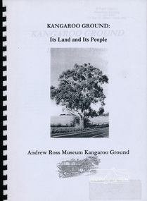
Book, Andrew Ross Museum, Kangaroo Ground: its Land and its People by Mick Woiwod published by Andrew Ross Museum, 2002
Kangaroo Ground's geology, original people, European settlers, plants used by Wurundjeri people26 leaves : ill., maps ; 30 cm.wurundjeri (australian people) -
 Eltham District Historical Society Inc
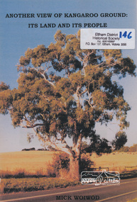
Book, Mick Woiwod, Another view of Kangaroo Ground : its land & its people / Mick Woiwod, 2009
Paperback; 54 p. : ill. (some col.), maps, port ; 30 cm.Inscribed and signed by Author wurundjeri, social customs, place names, yarra river, environment, kangaroo ground, culture, aborigines -
 Eltham District Historical Society Inc
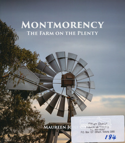
Book, Montmorency: The Farm on the Plenty by Maureen Jones, 2015
This book lays out the history of Montmorency from its earliest years as a hunting ground the Wurundjeri willam people, through its uptake by white settlers. Ownership of the land remained in the hands of one family for four generations spanning seventy years, before the land evolved through small farmlets into a suburb once part of the former Shire of Eltham, now part of Banyule City Council.Little has been written on the history of this hidden suburb of Melbourne. This book is significant in that it is the first major local history publication devoted to the suburb gathered particularly from local historical society archives and oral histories. ISBN 9780980807912montmorency -
 Victorian Interpretive Projects Inc.
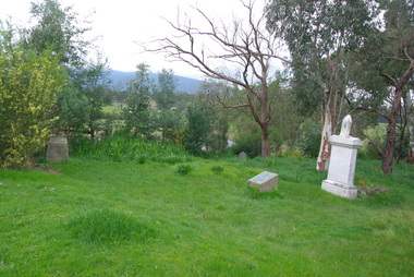
Photograph - Colour, Clare Gervasoni, Corenderrk Cemetery, 31/08/2011
In 1860 the Wurundjeri Elder, Wonga, petitioned the Victorian Parliament for a piece of land in his people’s own country where he could establish a settlement. The land later named Coranderrk was granted. When Wonga died in 1875 his nephew William Barak, known by settlers as ‘King William, last chief of the Yarra Yarra tribe’, became the leader, the Ngurungaeta. William Barak believed strongly in justice for his people, and time and again made the arduous walk to Melbourne to petition to Parliament and to Queen Victoria for his people. ‘Freedom for our lifetime’, he said. The community at Coranderrk welcomed Aboriginal people displaced from other parts of Victoria; they established an economically self-sufficient settlement by growing and marketing hops. Barak negotiated with the Victorian Government officials as they made promises and broke promises. They finally promised to export the whole of a hop harvest of one year. The people worked around the clock to fill the contract; the Government pocketed the proceeds. The community never recovered. Barak died in 1903— a broken-hearted man. (from http://www.sosj.org.au/_uploads/_cknw/files/Corenderrk.pdf) Artist William Barak is buried in this cemetery.Photographs of graves in grass and bushland. It is the Corenderrk Cemetery, and is associated with the former Corenderrk Aboriginal Reserve.corenderrk, wurundjeri, barak, aborigines, aboriginal, cemetery, grave, barak, jemima dunolly -
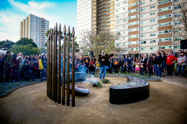 Yarra City Council
Artwork, other - Marker, Reko Rennie, Remember Me: Stolen Generations Marker, 2018
Kamilaroi artist Reko Rennie’s vision is an inclusive environment where people can sit and peacefully reflect on, mourn and acknowledge the deep trauma of the past, as well as connect with the ongoing strength and resilience of the Aboriginal community and support the process of healing. 'Remember Me' symbolises community resilience, identity and family. Positioned in a ceremonial ring, the seating and spears create a circle of gathering and remembrance within the park. In a contemporary and historical sense, the spear is an emblematic statement about struggle and adversity, and it is also an expression of identity and connection to land and culture.The 'Stolen Generations Marker, Remember Me', reflects the community’s wish to create a permanent tribute to the Stolen Generations and their families; a place of reflection and respectful commemoration. Integral to this is the surrounding garden with plants local to the area that have been re-introduced into the setting. Sited at the historically important Meeting Place in the heart of Aboriginal Fitzroy, the artwork honours not only the story of this place, but of all Aboriginal people who were taken away. This project was guided by the Stolen Generations Marker Steering Group and realised by Yarra City Council in partnership with the Victorian Government. Most importantly, it has received widespread grassroots community support. It was officially launched on the 20th anniversary of National Sorry Day (26 May 2018), which acknowledges the impact of the policies spanning more than 150 years of forcible removal of Aboriginal and Torres Strait Islander children from their families. On 26 May 1997 the landmark 'Bringing Them Home' report was tabled in Federal Parliament. The report was the result of a national inquiry that investigated the forced removal of Indigenous children from their families. This was a pivotal moment for many Stolen Generations. It was the first time the stories of forced removal were formally acknowledged by the Government and a recognition that these actions were inhumane. The impacts have been lifelong and intergenerational. A collection of bronze spears and a coolamon with accompanying seating, lighting and landscaping positioned in a ceremonial ring.stolen generations, fitzroy -
 Yarra City Council
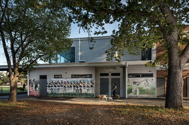
Artwork, other - Mural, Fiona McMonagle, The Park, 2022
'The first panel celebrates the long history of runners that use the park. Richmond Harriers Athletics Club was established in 1913 and is the oldest athletics club in Victoria. The central panel depicts young female footballers and recognises female athletes and the popularity of women and girls' teams in contemporary sports. The final panel depicts a children’s cricket match. The young players are represented through the depiction of a game that is part of our national psyche and firmly entrenched in Australian culture.'Inner-city parks like Citizens Park have many diverse uses. They provide places to play, to exercise and to relax. They are spaces for community and are often subject to competing values and interests. The re-development of the Jack Dyer Pavilion at Citizens Park allows for the growth of the local community’s diverse interests and values and enables participation and interaction. 'The Park' focuses on the recreational uses of Citizens Park and its role as a community space in an area that is changing rapidly. The mural consists of three panels that address inclusivity and access to sport. Three core sporting groups who each utilize the pavilion and park as a public recreational space are represented: children, sport teams and runners. In fostering the representation of these groups, the panels also attest to the past, present, and future of this important space.Three sporting groups are represented: athletics/runners, women footballers in line formation and young cricketers in action/play. Accompanying plaquesport, women, community, richmond, parks -
 Whitehorse Historical Society Inc.
Article, Wurundjeri Walk, 1988
Freeway land: Council may pay $3.3 million by Wendy Woods,Freeway land: Council may pay $3.3 million by Wendy Woods,Freeway land: Council may pay $3.3 million by Wendy Woods,healesville freeway reservation, fulton road, blackburn south, woods, wendy, roads and streets -
Whitehorse Historical Society Inc.
Document, Melbourne and Metropolitan Archaeological survey, 1/03/1982
History of Aboriginal occupation of the Melbourne area. Evidence of shell midden refuse associated with their campsites. Evidence of scarred trees and scatters of stone artefacts along major stream systems. It has been established that man was in the Melbourne area 40,000 years ago and that Aboriginal occupation probably continued uninterrupted throughout the extremes of the last ice age, around 20,000 years ago when Port Phillip itself was dry land. Study will take 2 - 3 years. Aims (1) identify areas of potential archaeological importance (2) implement a pilot survey program (3) prepare comprehensive proposals for survey of sites. (4) liaise and establish rapport with municipal authorities in study area.aborigines, wurundjeri, bunurong, australian heritage commission, victoria. ministry for conservation, victoria archaeological survey -
Bialik College
Flyer (item) - Ngarrgee, 2020
Invitations sent to school community and running sheets for Ngarrgee events 2020- to acknowledge the traditional owners of the land, Rosh Hashanah, and to welcome the new Year 12 leadership cohort, the Mazkirut. 'Ngarrgee' is a Wurundjeri word meaning 'coming together'. The school's RAP Committee advised in 2020: 'Following on from the very successful Welcome to Country smoking ceremony in 2019, which was appropriately aligned with Rosh Hashanah, we are continuing with this new tradition by hosting the same event on Tuesday 15 September at 8.00pm via the ZOOM platform. Adapting to current circumstances, the smoking ceremony will be led by Murrundindi, Ngurungaeta (Head Man) for the Wurundjeri clan, from his property in Healesville. This year, the event will also incorporate the Mazkirut Induction ceremony.' Please contact [email protected] to request access to this record. event, celebration, year 12, 2020s -
 Kew Historical Society Inc
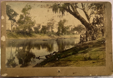
Photograph - Wurundjeri People at Studley Park
The Wurundjeri Woi Wurrung People were the original owners of the land on which the City of Boroondara is now located. They made active use of the Yarra for food and transport [an original canoe is held in the collection of the Melbourne Museum]. From 1863, members of the Wurundjeri Woi Wurrung were resettled at the Corranderrk Aboriginal reserve at Healesville. The [now] best known member of the Wurundjeri People was William Barak, who may be pictured here.If the attribution in the annotation is correct, then this may be the earliest photograph of members of the Wurundjeri People at Kew. The photo may be unique.Hand tinted photograph on mounting card of members of the Wurundjeri Woi Wurrung on the banks of the River Yarra, allegedly at Studley Park before 1855 [according to the annotation on the reverse] The photograph of the river and its near and far banks includes two boats on the river, a row boat and a canoe, and people standing on the near bank or seated on the branch of a tree. In addition to men and women of the Wurundjeri People, there appears to be two Europeans pictured, one wearing a hat and the other standing at right. Annotations on the reverse identify a [possible] location and date. [Size: Mount 140 x 215mm | Photograph 125 x 190mm]Various hands and dates: "Original lead pencil lettering Studley Yarra Yarra / Yarra Yarra Studley / Studley (Park?) / Note aboriginals in a bark canoe / Prior 1855 / Very early photo Yarra River originally known as the Yarra Yarra / [illegible part word in ink]".wurundjeri woi wurrung, yarra river, aboriginal and torres straight islander -
 Kew Historical Society Inc
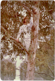
Photograph - Historic re-enactment during the Festival of Kew, 1978
At the 1978 Festival of Kew, a number of organisations, including the City of Kew, the Kew Historical Society, Trinity Boys Grammar School and local Girl Guides participated in a re-enactment of the expedition of the party of Charles Grimes in surveying the Yarra River as far as Kew in February 1803. The location for the event was Yarra Bend Park near the Studley Park Boat House. The event was organised by the Kew Historical Society. The re-enactment was captured by a number of amateur photographers as well as by a photographer from the local Progress Press.Local communities select events to commemorate according to their shared history and values. Commemorations of colonial exploration were popular with local historical groups such as the Kew Historical Society in the twentieth century. In re-enacting events such as the Grimes survey of the Yarra, students from a local school were encouraged to take on specific roles, including play-acting individuals involved in the survey party as well as members of the local Wurundjeri People. The photographs, taken by amateur and professional photographers, represent a period in time when the dominant values were those shared by the descendants of European settlers in Victoria. Original colour photographic positive showing a boy from Trinity Grammar School in a tree, role-playing Captain Robbins, a member of Grimes' survey party.Annotated on reverse: "CAPTAIN ROBBINS LOOKING UP THE YARRA AND REPORTING: 'A LAND THAT OFFERS GREAT OPPORTUNITY FOR SETTLEMENT' / RE-ENACTED BY A TRINITY BOY / 1978 FESTIVAL"kew historical society, trinity grammar school, kew girl guides, city of kew, yarra river, charles grimes, collins expedition, wurundjeri people, yarra bend park, colonial surveys, historic re-enactments, festival of kew, kew festival -
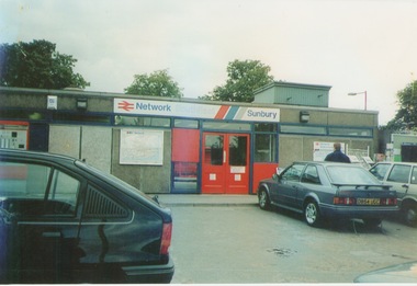 Sunbury Family History and Heritage Society Inc.
Photograph, September 1996
The photograph shows the railway station at Sunbury in Surrey in the United Kingdom. The town of Sunbury in Victoria was named after the English township of Sunbury-on-Thames in Middlesex by the Jackson Brothers who took up land in Sunbury, Victoria. The area was originally known as Koora Kooracup by the Wurundjeri people.Sunbury in Victoria like many other settlements in Australia were given names of towns in the United KingdomA coloured photograph of a railway station with three cars parked outside the building, which has grey walls and scarlet and blue trims. There are framed maps and notices on the exterior walls. -
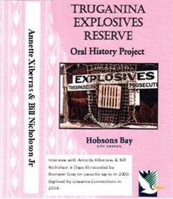 Truganina Explosives Reserve Preservation Society Inc (TERPS)
Digitised Oral History – Truganina Explosives Reserve - Tape 8 Annette Xibarras and Bill Nicholson Jnr, 2018
The interviews were recorded in 2000 by Bronwen Gray and Alan Young for the production of Unreserved, Stories from Truganina Explosives Reserve, animated stories from past residents, workers and interested people of the Reserve (subject to copyright 2004). Annette Xibarras and Bill Nicholson Jnr discuss the indigenous significance of the Truganina Explosives Reserve. At the time of the interview Annette was the manager of the Kulin Nations Cultural Heritage Organisation. Bill, a Wurundjeri Elder, was a Wurundjeri Cultural Officer. They discussed their childhood, aboriginal customs, connection with the land and the locating of aboriginal remains at the Museum of Victoria and the re-burial at the site where they were found. A primary source of information on memories of the Truganina Explosives Reserve and Altona,VictoriaDigital copy of original cassette recorded in 2000 and digitised in 2018julia jones, princess balam balam, archaeological survey, middens, wurundjeri, kulin nations, coranderrk, braybrook, sacred sites, mt william, bunurong, museum victoria, altona, martha nicholson -
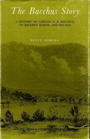 Bacchus Marsh & District Historical Society
Book, The Bacchus Story: A History of Captain W. H. Bacchus of Bacchus Marsh and His Son, 1973
... which was later named after him. He arrived in land occupied ...William Bacchus was one of the first European colonists to live in the township which was later named after him. He arrived in land occupied by the Wurundjeri and Wadawurrung peoples in 1838 and established a large sheep farm. He died in 1849 and his son Henry Bacchus continued his farming interests in the district until his death in 1887. This work is a biographical portrait of William and Henry Bacchus and of the early European occupation in the Bacchus Marsh district. PUBLICATION DETAILS: Bacchus Marsh, Vic., Bacchus Marsh and District Historical Society Inc., 1973:118 pages, 23 cm.non-fictionWilliam Bacchus was one of the first European colonists to live in the township which was later named after him. He arrived in land occupied by the Wurundjeri and Wadawurrung peoples in 1838 and established a large sheep farm. He died in 1849 and his son Henry Bacchus continued his farming interests in the district until his death in 1887. This work is a biographical portrait of William and Henry Bacchus and of the early European occupation in the Bacchus Marsh district. PUBLICATION DETAILS: Bacchus Marsh, Vic., Bacchus Marsh and District Historical Society Inc., 1973: william bacchus, bacchus family, henry bacchus, bacchus marsh, bmdhs publication -
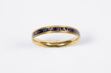 Bacchus Marsh & District Historical Society
Accessory - Ring, Mourning Ring commemorating the death of Wm Bacchus, Esq., 10th June, 1788
This ring belonged to Captain William Henry Bacchus who was one of the first British colonists to establish a farming property on Wurundjeri and Wadawurrung First Nations people lands 55 kilometers west of Melbourne. The land occupied by Bacchus in 1838 came to be known by the early colonists as Bacchus’s Marsh before later changing officially to Bacchus Marsh. The ring is believed to have been made to commemorate the death of Captain Bacchus’s father Wm (William) Bacchus in Somerset, England in 1788.This ring has significance because it is an object associated with a significant historical person in the history of the region of Bacchus Marsh. It is a rare, probably unique example of an 18th century mourning ring connected to the local community. It also has aesthetic value as an object and is in excellent condition.Gold ring with blue and black coloured inlay. Contains writing on the outsideWM Bacchus Esq OB: 10th JUNE 1788 Æ: 38 bacchus family, rings, william henry bacchus 1782-1849 -
 Eltham District Historical Society Inc
Photograph - Digital Photograph, Alan King, Golden King Mine poppet-head, Yarrambat Primary School, 1 February 2008
The Golden King Mine poppet-head stands at the school’s Yan Yean Road exit gate. Published: Nillumbik Now and Then / Marguerite Marshall 2008; photographs Alan King with Marguerite Marshall.; p23 Early Yarambat - Tanck's Corner Its early settlers, who in the 1840s were amongst the first non-Aboriginal people in the area, found life tough as they grazed their sheep and cattle. Yarrambat was then known as Tanck’s Corner or Reynolds Corner, after wood carter, Frederick Tanck, who owned land north of Ironbark Road, at the corner of Yan Yean Road, and Thomas Reynolds, owner of the opposite property. After Reynolds sold his land, the corner became known as Tanck’s Corner. In 1929 the district’s name was changed to Yarrambat, believed to mean ‘high hill’ in the Wurundjeri language. Tanck’s Corner was in the centre of gold-bearing country and the district is honeycombed with old tunnels and shafts. However although gold played a dominant role for decades, there was insufficient to develop a substantial township. Meat and agricultural produce made a greater impact. Until the mid-20th century the only substantial building was the primary school. The first gold rush occurred around 1860, the second after 1900; then during the Depression, the Government paid men to pan for gold. The first rush attracted hundreds of Chinese people to Smugglers Gully, who constructed round diggings to keep away spirits. Alluvial miners lived along the Plenty River in tents or humpies - some fenced with gardens - and some miners distilled their own ‘plonk’. It was a wild time and bushrangers - and later gangster Squizzy Taylor - were said to hide4 in the old Pioneer Tunnel in Dunne’s Gully between Heard Avenue and Pioneer Road. Mines opposite Tanck’s Corner included Beer’s Line, Golden Crown and Golden Stairs. Some of the big mines had batteries and stampers to process quartz. At first there was plenty of alluvial gold, as much as two ounces to the ton. At times gold was exposed after heavy rains so fossickers panned for gold around orchard irrigation trenches. Gold was mined until 1984 when Yarrambat’s last operating goldmine, the Golden King Mine, in North Oatlands Road, closed. The Clayton family operated it full-time, making a comfortable living and in the 1960s it was the only private family gold mine in Victoria.5 Gold was such an important part of Yarrambat’s history that a gold poppet-head is the Yarrambat Primary School’s logo. The Golden King Mine poppet-head stands at the school’s Yan Yean Road exit gate. However this school was built in 1988. The original school No 2054, at the corner of Ironbark and Yan Yean Roads, was opened in 1878 and modified to its present form in the 1920s. In 2000 it was relocated to the Heritage Museum at Yarrambat Park.7 The school, whose first head teacher was Charles Planner, consisted of one room with a three-roomed residence. The school was also the community centre. On Saturday nights it was crammed for dances or euchre parties, community singing or other social events. On Sundays, services for different denominations took turns each week. However the school had its teething problems. Parents accused Charles Planner of neglecting his duties and the school closed several times. When it closed in 1892, only church services continued. Social activities moved elsewhere, such as the tennis club to the Stuchbery tennis court opposite. A sports day and woodchop on Boxing Day around 1900 was held at the Evelyn Hill Hotel, also called Evelyn Arms and Tunnel Hill Hotel, on the Greensborough–Diamond Creek Road. An annual agricultural show in Diamond Creek paraded through the town, and New Year’s Day picnics at the Yan Yean Reservoir included highland dancing and competitions. Also popular were the Indian hawkers who visited every three months, selling trinkets, clothing and other items. One called Jimmy ‘Allem dem Bedi’, gave presents and told stories, played draughts and sold delicious curries he cooked over his camp fire at night.This collection of almost 130 photos about places and people within the Shire of Nillumbik, an urban and rural municipality in Melbourne's north, contributes to an understanding of the history of the Shire. Published in 2008 immediately prior to the Black Saturday bushfires of February 7, 2009, it documents sites that were impacted, and in some cases destroyed by the fires. It includes photographs taken especially for the publication, creating a unique time capsule representing the Shire in the early 21st century. It remains the most recent comprehenesive publication devoted to the Shire's history connecting local residents to the past. nillumbik now and then (marshall-king) collection, golden king mine, tanck's corner, yarrambat primary school -
 Eltham District Historical Society Inc
Photograph - Digital Photograph, Marguerite Marshall, Eltham Lower Park, 20 April 2008
Originally a race course, the park has brought the community together with a variety of activities. Published: Nillumbik Now and Then / Marguerite Marshall 2008; photographs Alan King with Marguerite Marshall.; p45 Once used for horse racing, which attracted visitors from Melbourne, the Eltham Lower Park has brought the community together with a wide range of activities. Horse riding is now enjoyed as a recreation in the park as are other sports. The park also includes the Diamond Valley Railway miniature trains and a sanctuary for the rare and vulnerable Eltham Copper Butterfly. Eltham Lower Park, with other parks, forms an almost continuous green band from Eltham’s centre, along the Diamond Creek to the Yarra River.1 Before European settlement the Wurundjeri people met on this land, particularly at the junction of the Diamond Creek with the Yarra River, which they called Birr-arung. This is commemorated by the sculpture, Not just a Pretty Place by Aleks Danko, winner of the 2000 Nillumbik Art in Public Places Award. The first European to settle here was probably Henry Foley, who in 1841 used it as part of his pastoral run. Foley sold his leasehold to Joseph Wilson in 1845, who soon after sold it to Frederick Falkiner. During the 1840s the future park was part of a government square mile (2.6 sqkm) reserve, north of the Yarra, within the Parish of Nillumbik, later named Eltham. Soon the land was used for horse racing after nearby residents cleared ten acres (4ha) in the early 1850s. A three-quarter of a mile (1.2km) race secured the winner the £10 Publican’s Prize. In response to popular demand, the newly formed Eltham District Road Board petitioned the Surveyor General of the Colony of Victoria, in 1856, for 36 acres (14.6ha) of crown land for a racecourse and recreation. By 1858 the Eltham races had become an institution. ‘Many skirmishes occurred and the way home was paved with temptation, with sly-grog for sale.3 In the early 1870s, two jockeys were sons of the police officer in charge of the Eltham Police Station, Miles S Lyons. Another ten acres (4ha) was added to the area in 1866 and 12 acres (4.8ha) – Hohnes Hill – in 1870. In 1866, two acres (0.8ha) on the creek banks became an animal pound with William Walsh the pound keeper in 1870, but this was later incorporated into the park. By 1877 the area was called a public park but horse racing and training continued into the 1920s. In the mid-1900s trotters were trained on a circuit road. In 1953 the Eltham Pony Club was established and used a cross-country course on Hohnes Hill. From the mid 1950s the club held the Eltham Easter Fair at the park, later to include a procession along Main Road from the town centre to the park. The park also attracted picnic parties and campers from the inner suburbs as did Wingrove Park, and businesses catering for visitors, sprang up on the opposite side of Main Road. Bus-loads of school children visited the park for Gould League bird days in the 1960s. In 1979 the Eltham Shire Council bought Lenister Farm, linking the park with the Yarra River. The Lenister Farm wetland includes a bird hide, viewing platform and interpretive signs.5 Pioneer Henry Stooke, later Road Board chairman, bought the 11 acres (4.5ha) - later to become Lenister Farm - from the Crown in 1862. Stooke never lived on this site and the two houses at Lenister Farm were built in the 20th century. Since its formation in 1871, the Council has controlled this crown land, which it named Eltham Park. But in the 1920s Eltham Council bought land near the town centre for a park, which it named Eltham Central Park. To avoid confusion the Council renamed Eltham Park, Eltham Lower Park. Since 2004 the Yarra footbridge has linked the park with the Yarra Valley Metropolitan Park and the Main Yarra Trail.This collection of almost 130 photos about places and people within the Shire of Nillumbik, an urban and rural municipality in Melbourne's north, contributes to an understanding of the history of the Shire. Published in 2008 immediately prior to the Black Saturday bushfires of February 7, 2009, it documents sites that were impacted, and in some cases destroyed by the fires. It includes photographs taken especially for the publication, creating a unique time capsule representing the Shire in the early 21st century. It remains the most recent comprehenesive publication devoted to the Shire's history connecting local residents to the past. nillumbik now and then (marshall-king) collection, eltham lower park, eltham park -
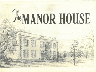 Bacchus Marsh & District Historical Society
Pamphlet, The Manor House
... (Bacchus Marsh) was later named after him. He arrived on land ...This pamphlet outlines the early history of the house constructed for William Bacchus in 1846-1847 and briefly describes its condition as it was in 1957. William Bacchus was one of the first European colonists to live in the area in which a township (Bacchus Marsh) was later named after him. He arrived on land occupied by the Wurundjeri and Wadawurrung peoples in 1838 and established a large sheep farm. Between 1846 and 1847 he contracted builders and other skilled workers to construct a large brick and stone two storey house. William Bacchus died in 1849. His son Henry Bacchus sold the house in 1851. For many years it was owned by the Crook family. When this pamphlet was published in 1957 the house was owned by the Lifeguard Milk Company of Bacchus Marsh. By this time the property had become derelict and was almost demolished. Around this time the Young Mens Christian Association Club in Bacchus Marsh became involved in efforts to help preserve this historic property. This pamphlet was part of those efforts. PUBLICATION DETAILS: Y's Mens Club Bacchus Marsh, Bacchus Marsh, Vic., 1957. Text written by Ronald G. Westood.Small pamphlet. Stapled softcover. 23 unnumbered pages. 11cm x 16cm. Contains photographs and cover illustration. BMDHS Location: AR/SU5 Pamphlets Box 4.non-fictionThis pamphlet outlines the early history of the house constructed for William Bacchus in 1846-1847 and briefly describes its condition as it was in 1957. William Bacchus was one of the first European colonists to live in the area in which a township (Bacchus Marsh) was later named after him. He arrived on land occupied by the Wurundjeri and Wadawurrung peoples in 1838 and established a large sheep farm. Between 1846 and 1847 he contracted builders and other skilled workers to construct a large brick and stone two storey house. William Bacchus died in 1849. His son Henry Bacchus sold the house in 1851. For many years it was owned by the Crook family. When this pamphlet was published in 1957 the house was owned by the Lifeguard Milk Company of Bacchus Marsh. By this time the property had become derelict and was almost demolished. Around this time the Young Mens Christian Association Club in Bacchus Marsh became involved in efforts to help preserve this historic property. This pamphlet was part of those efforts. PUBLICATION DETAILS: Y's Mens Club Bacchus Marsh, Bacchus Marsh, Vic., 1957. Text written by Ronald G. Westood. william bacchus, bacchus family, henry bacchus, bacchus marsh, manor house bacchus marsh, houses bacchus marsh, historic buildings bacchus marsh -
 Eltham District Historical Society Inc
Photograph - Digital Photograph, Alan King, Blue Lake, Plenty Gorge Park, 2008
A quarry was transformed into the Blue Lake. Published: Nillumbik Now and Then / Marguerite Marshall 2008; photographs Alan King with Marguerite Marshall.; p179 The dramatic steep-sided Plenty Gorge lies along the divide of two geological areas, and separates the Nillumbik Shire and the City of Whittlesea. On the Nillumbik side are undulating hills and sedimentary rock, and in Whittlesea, lies a basalt plain formed by volcanic action up to two million years ago. This provides the Plenty Gorge Park with diverse vegetation and habitats, making it one of Greater Melbourne’s most important refuges for threatened and significant species. The park, established in 1986, consists of around 1350 hectares, and extends 11 kilometres along the Plenty River, from Greensborough to Mernda. It provides a wildlife corridor for around 500 native plant and 280 animal species. The area’s plentiful food and water attracted the Wurundjeri Aboriginal people and then European settlers. By 1837 squatters had claimed large runs of land for their sheep and cattle. The Plenty Valley was among the first in the Port Phillip District to be settled - mainly in the less heavily timbered west - and was proclaimed a settled district in 1841.But by the late 1880s, the settlers’ extensive land clearing for animal grazing, then agriculture, depleted the Wurundjeri’s traditional food sources, which helped to drive them away. Many Wurundjeri artefacts remain (now government protected), and so far 57 sites have been identified in the park, including scarred trees, burial areas and stone artefacts. Pioneer life could be very hard because of isolation, flooding, bushfires and bushrangers. Following the Black Thursday bushfires of 1851, basalt was quarried to build more fire-resistant homes. Gold discoveries in the early 1850s swelled the population, particularly around Smugglers Gully; but food production made more of an impact. In the late 1850s wheat production supplanted grazing. In the 1860s the government made small holdings available to poorer settlers. These had the greatest effect on the district, particularly in Doreen and Yarrambat, where orchards were established from the 1880s to 1914. Links with a prominent early family are the remains of Stuchbery Farm, by the river’s edge bounded by Smugglers Gully to the north and La Trobe Road, Yarrambat, to the east. The Stuchberys moved to the valley in 1890, and the family still lives in the area. In 1890, Alfred and Ada first lived in a tent where four children were born, then Alfred built the house and outbuildings around 1896. They planted an orchard, then a market garden, and developed a dairy. The family belonged to the local Methodist and tennis communities. Their grandson Walter, opened the Flying Scotsman Model Railway Museum in Yarrambat, which his widow, Vi, continues to run. Wal was also the Yarrambat CFA Captain for 22 years until 1987. Walter sold 24 hectares in 1976 for development - now Vista Court - and in 1990, the remaining 22.6 hectares for the park. Remaining are an early stone dairy and remnants of a stone barn, a pig sty and a well. Until it was destroyed by fire in 2003, a slab hut stood on the Happy Hollow Farm site, at the southern end of the park. The hut is thought to have been built in the Depression around 1893. This was a rare and late example of a slab hut with a domestic orchard close to Melbourne. Emmet Watmough and his family first occupied the hut, followed by a succession of families, until the Bell family bought it around 1948. There they led a subsistence lifestyle for 50 years, despite encroaching Melbourne suburbia. The Yellow Gum Recreation Area includes the Blue Lake, coloured turquoise at certain times of the year. Following the 1957 bushfires, this area was quarried by Reid Quarries Pty Ltd for Melbourne’s first skyscrapers, then by Boral Australia. However in the early 1970s water began seeping into the quarry forming the Blue Lake and the quarry was closed. The State Government bought the site in 1997 and opened it as a park in 1999.This collection of almost 130 photos about places and people within the Shire of Nillumbik, an urban and rural municipality in Melbourne's north, contributes to an understanding of the history of the Shire. Published in 2008 immediately prior to the Black Saturday bushfires of February 7, 2009, it documents sites that were impacted, and in some cases destroyed by the fires. It includes photographs taken especially for the publication, creating a unique time capsule representing the Shire in the early 21st century. It remains the most recent comprehenesive publication devoted to the Shire's history connecting local residents to the past. nillumbik now and then (marshall-king) collection, blue lake, plenty gorge park -
 Eltham District Historical Society Inc
Photograph - Digital Photograph, Marguerite Marshall, Stuchbery Farm dairy, 14 March 2008
Stuchbery Farm was situated on the Plenty River bounded by Smugglers Gully to the north and La trobe Road, Yarrambat, to the east. Alan and Ada Stutchbery moved to the valley in 1890, first living in a tent where four children were born. Alfred built a home and outbuildings around 1896. They planted an orchard, then a market garden and developed a dairy. Published: Nillumbik Now and Then / Marguerite Marshall 2008; photographs Alan King with Marguerite Marshall.; p179 The dramatic steep-sided Plenty Gorge lies along the divide of two geological areas, and separates the Nillumbik Shire and the City of Whittlesea. On the Nillumbik side are undulating hills and sedimentary rock, and in Whittlesea, lies a basalt plain formed by volcanic action up to two million years ago. This provides the Plenty Gorge Park with diverse vegetation and habitats, making it one of Greater Melbourne’s most important refuges for threatened and significant species. The park, established in 1986, consists of around 1350 hectares, and extends 11 kilometres along the Plenty River, from Greensborough to Mernda. It provides a wildlife corridor for around 500 native plant and 280 animal species. The area’s plentiful food and water attracted the Wurundjeri Aboriginal people and then European settlers. By 1837 squatters had claimed large runs of land for their sheep and cattle. The Plenty Valley was among the first in the Port Phillip District to be settled - mainly in the less heavily timbered west - and was proclaimed a settled district in 1841. But by the late 1880s, the settlers’ extensive land clearing for animal grazing, then agriculture, depleted the Wurundjeri’s traditional food sources, which helped to drive them away. Many Wurundjeri artefacts remain (now government protected), and so far 57 sites have been identified in the park, including scarred trees, burial areas and stone artefacts. Pioneer life could be very hard because of isolation, flooding, bushfires and bushrangers. Following the Black Thursday bushfires of 1851, basalt was quarried to build more fire-resistant homes. Gold discoveries in the early 1850s swelled the population, particularly around Smugglers Gully; but food production made more of an impact. In the late 1850s wheat production supplanted grazing. In the 1860s the government made small holdings available to poorer settlers. These had the greatest effect on the district, particularly in Doreen and Yarrambat, where orchards were established from the 1880s to 1914. Links with a prominent early family are the remains of Stuchbery Farm, by the river’s edge bounded by Smugglers Gully to the north and La Trobe Road, Yarrambat, to the east. The Stuchberys moved to the valley in 1890, and the family still lives in the area. In 1890, Alfred and Ada first lived in a tent where four children were born, then Alfred built the house and outbuildings around 1896. They planted an orchard, then a market garden, and developed a dairy. The family belonged to the local Methodist and tennis communities. Their grandson Walter, opened the Flying Scotsman Model Railway Museum in Yarrambat, which his widow, Vi, continues to run. Wal was also the Yarrambat CFA Captain for 22 years until 1987. Walter sold 24 hectares in 1976 for development - now Vista Court - and in 1990, the remaining 22.6 hectares for the park. Remaining are an early stone dairy and remnants of a stone barn, a pig sty and a well. Until it was destroyed by fire in 2003, a slab hut stood on the Happy Hollow Farm site, at the southern end of the park. The hut is thought to have been built in the Depression around 1893. This was a rare and late example of a slab hut with a domestic orchard close to Melbourne. Emmet Watmough and his family first occupied the hut, followed by a succession of families, until the Bell family bought it around 1948. There they led a subsistence lifestyle for 50 years, despite encroaching Melbourne suburbia. The Yellow Gum Recreation Area includes the Blue Lake, coloured turquoise at certain times of the year. Following the 1957 bushfires, this area was quarried by Reid Quarries Pty Ltd for Melbourne’s first skyscrapers, then by Boral Australia. However in the early 1970s water began seeping into the quarry forming the Blue Lake and the quarry was closed. The State Government bought the site in 1997 and opened it as a park in 1999.This collection of almost 130 photos about places and people within the Shire of Nillumbik, an urban and rural municipality in Melbourne's north, contributes to an understanding of the history of the Shire. Published in 2008 immediately prior to the Black Saturday bushfires of February 7, 2009, it documents sites that were impacted, and in some cases destroyed by the fires. It includes photographs taken especially for the publication, creating a unique time capsule representing the Shire in the early 21st century. It remains the most recent comprehenesive publication devoted to the Shire's history connecting local residents to the past. nillumbik now and then (marshall-king) collection, ada stuchbery, alan stuchbery, dairy, stuchbery farm, farm buildings, yarrambat, plenty gorge park -
 Merri-bek City Council
Painting - Oil on linen, Renee Cosgrave, Learning Whakapapa (Māori Land Court Archives), 2023