Showing 5277 items
matching 1856-1979
-
 Melbourne Legacy
Photograph - Junior legatee outing, Somers Camp 1979, 1979
Photograph of a large group of boys playing tug of war on beach. From the inscription it was at Somers Camp in January 1979. Melbourne Legacy provided camps for junior legatees. It started with outings to the property of Legacy founder, Legatee Stan Savige, who had a place in Balnarring. Permanent camp buildings were built and with an association with Lord Somers (Governor of Victoria) it was called Somers Camp. The camps gave the children an opportunity of a summer beach holiday with other Legacy children.A record of Junior Legatees enjoying an outing or a camp.Black and white photo of children playing tug of war on a beach January 1979."Jan 79" in blue pen on reverse. Stamped "Copyright / The Herald and Weekly Times" in blue ink. Stamped "The Property of Melbourne Legacy" in purple ink on reverse.somers camp, camp, junior legatee outing, beach -
 Melbourne Legacy
Document - Report, USP Needham Pty Ltd, 56th Annual Report 1979, 1979
The Melbourne Legacy 1979 - 56th Annual Report with presidents report and photos of events through the year. The President was Legatee Bill Mehan. It mentions there were more than 900 members of Melbourne Legacy. The executive officer Ivan Layton had been inducted into Melbourne Legacy before he went on sick leave. Unfortunately he passed away leaving a contribution of almost 30 years service. The widows club rooms were renovated and reopened with 350 widows in attendance. A record of the annual reports of Legacy Melbourne, including records of names of Legatees, beneficiaries, supporters, telling stories of Legacy's impact and summarising annual financial information.Annual report from 1979 published on paper with black type and black and white photos.financial summary, annual summary, bill mehan -
 Stawell Historical Society Inc
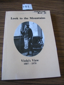
Book, Catherine Good, Look to the Mountains – Viola’s View 1887-1979, 1985
Recollections of a long life 1887-1979 Including childhood at Carrs Plains. Growing up in the Grampians the 90 years of Violet Good (nee Wettenhall) Orange card, Black Print B/W oval photo of a young woman standing next to a leather chair looking out a window Looking to the Mountains Viola's View 1887 - 1979stawell -
 Greensborough Historical Society
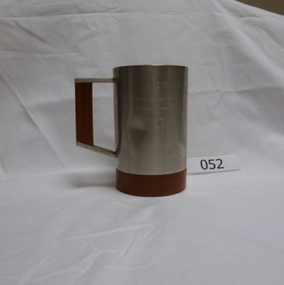
Award - Cup, G.C.C. Double Wicket Championship. Runners-up 1979/80, 1979-1980
Presented to players in the Greensborough Cricket Club who were runners-up in the Double Wicket cricket competition during the 1979-1980 season.One of a limited number produced and engraved for this purpose. Owned by player Doug Hall.Pewter mug on a wood base with square pewter and wood handleEngraved on cup: G.C.C. Double Wicket Championship. Runners up. 1979/80. Donated by Sportsfield Bundoora. On base: Selwin Pewter.doug hall, greensborough cricket club -
 Lakes Entrance Historical Society
Book, Ellem, Elizabeth Wood, Victoria Felix A celebration of the 50th Parliament of Victoria 1856-1985, 1985
A History of the system of government in Victoria, from the first Parliament in 1856 until the 50th. Parliament in 1985. Illustrated with sketches, plans and photographs.history, government, buildings, politics -
Ringwood and District Historical Society
Company papers, Clocktower Theatre Company, Clocktower Theatre Company: minutes, correspondence, constitution etc. Ringwood. 1971 to 1979, 1971-1979
The collection of papers pertains to the running of the Clocktower Theatre Company, members and productions from 1971 to 1979.Several manila folders of minutes, correspondence dealing with the running of the Clocktower Theatre Company.; 4604.1 - Minutes of Committee Meetings Feb 1973 to Dec 1976; 4604.2 - Inward correspondence 1971-1979; 4604.3 - Correspondence in/out for fund raising activities, rehearsal halls; 4604.4 - Play licences 1974 - 1979; 4604.5 - Membership; 4604.6 - Circulars; 4604.7 - Constitution; 4604.8 - Application for Assistance 1971/72; 4604.9 - Applications for membership; 4604.10 - Membership lists; 4604.11 - Newsletters & miscellaneous +Additional Keywords: Grimshaw, H. (President) / Carter, A. (President) -
 Buninyong & District Historical Society
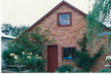
Photograph - Original Photograph, Robert Allen's house (1856-57) Eyre St. Buninyong, outhouse, rebuilt 1988, incorporating part of original stable, 9/11/1991
historic building, rebuildingColour photograph, Robert Allen's house (1856-57) Eyre St. Buninyong, outhouse, rebuilt 1988, incorporating part of original stable.buninyong, outhouse, robert allen -
 Broadmeadows Historical Society & Museum
Photograph - School Photo, Jacana Primary School Softball Premiers 1979, 1979
This group photograph of the 1979 Jacana Primary School Softball Premiers highlights the school’s proud sporting tradition and its role in fostering teamwork, resilience, and school spirit. Established in 1959 and operating until the early 2000s, Jacana Primary was a cornerstone of the local community, offering not only academic education but also rich extracurricular opportunities. The image captures a moment of achievement and pride, reflecting the camaraderie and collective effort that defined the school’s culture. As a visual record, it provides insight into the everyday life of the school and illustrates the broader social and educational values that shaped the Jacana community during this period.This 1979 photograph of the Jacana Primary School Softball Premiers is significant as a testament to the school’s vibrant sporting culture and its broader role in fostering community spirit and student development. As a key part of Jacana Primary School’s legacy—an institution that served the local community from 1959 until its closure in the early 2000s—the image captures a moment of athletic achievement and collective pride. It reflects the school’s commitment to extracurricular excellence, teamwork, and inclusion, offering a valuable visual record of the social and educational values that shaped the lives of its students and the identity of the Jacana community.A glossy colour photo of Jacana primary schools' softball premiers' female students of 1979. Teacher is in the middle.jacana primary school, education, photograph, group photograph, 1979 -
 City of Moorabbin Historical Society (Operating the Box Cottage Museum)
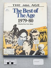
Book - Library Book The Age Newspaper Stories from 1979--1980, The best of the Age 1979---1980 Edited by Peter Cole-Adams, First published 1980
A large paperback book with laminated black and white covers. It has a montage of people and events on both front and back covers.age, newspaper, best, journalism, -
Ringwood and District Historical Society
Report, Radden, W.W.L, History of Anderson's Creek 1856-1865 by W.W.L. Radden January 1965, Jan-65
History of Anderson's Creek 1856-1865 - 7 foolscap pages and map prepared by W.W.L. Radden January 1965 +Additional Keywords: Radden, W.W.L. -
 Melbourne Legacy
Film - Video tape, Appeal 1979, 1979
A film that recorded Paul Cronin for the Legacy Appeal in 1979.A record that celebrities were part of the Legacy Appeals in the 1970s.Cardboard box containing TV tape.Appeal 1979 TV tape Paul Cronin Armstrong audio/video 180 Banks Street, South Melbourne PO Box 296 Victoria, 3205 Australia Telephone (03) 699 1844legacy appeal, legacy promotion, fundraising -
 Friends of Ballarat Botanical Gardens History Group
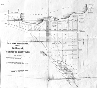
Work on paper - Suburban Allotments (west of) Ballaarat, Wendouree or Yuille's Swamp, County of Grenville 30/4/1856, 30/4/1856. No date given for photocopy
This map of the 1856 survey shows the numbered suburban allotments and the boundaries surrounding this area including Wendouree or Yuilles's Swamp close to where the Ballarat Botanical Gardens and the Lake exist today. This map gives a clear idea of an early survey of this western area and directions to areas of Ballarat surrounding these allotments.2 pages of the same map, except p.2 shows the Township Reserve on the lefthand side of the page. On the back of p.2, righthand corner is the Public Records Stamp.P2, righthand corner is the citation in pencil.john garner, doctor john garner, ballarat botanical gardens, friends of ballarat botanical gardens, map of western suburban allotments 1856, county of grenville, public record office of victoria, john garner collection, gardens, ballarat -
 Stawell Historical Society Inc
Photograph, Concongella Primary School Students 1979, 1979
Colour Photograph of Studnets & TeacherConcongella Primary School 1979education, students -
 Greensborough Historical Society
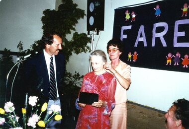
Photograph, Farewell Miss Richards 1979, 1979_11
Photograph of Janefield Special School staff farewell for Miss L. Richards in November 19792 colour photographsCaption on back: "Nov. 1979. Mr J. Monk, Miss L. Richards, Mrs J. Phillips". janefield, janefield special school, janefield staff -
RMIT GSBL Justice Smith Collection
Report, Sentencing: reform options : discussion paper no. 10 : June 1979, 1979
Discussion paper no. 10 June 1979ISBN: 0642906963law reform -- australia -- australian capital territory, punishment -- australia -- australian capital territory, sentences (criminal procedure) -- australia -- australian capital territory, law courts. sentencing. australian capital territory. proposals, sentences (criminal procedure) -- australia, sentences (criminal procedure) -- australian capital territory -
 Ballarat Tramway Museum
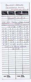
Document - Table Cards, Melbourne and Metropolitan Tramways Board (MMTB), 1979 Australia Day (29/1/1979) Cavalcade, Jan. 1979
Yields information about the arrangements for the Australia Day Cavalcades and the way crews were arranged.Heavy card printed as a M&MTB driver run table used for the 1979 Australia Day (29/1/1979) Cavalcade with BTPS tram No. 14. Gives time ex Preston and times ex Spencer & LaTrobe and ex Swanston and car in at Preston depot. In blue and red ink. Image of items added 2/11/13.trams, tramways, mmtb, btps, melbourne, australia day -
 Melbourne Legacy
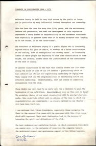
Document, Comments on Presidential Year 1979 - WR Mehan, 1980
The President in 1979 was WR Mehan. He comments on the reputation of Melbourne Legacy in the community and its continuity. Document is dated 28/3/1980 as the presidential year ran from March to the following February. Was in a binder of documents that is passed from an outgoing President to the incoming President. It is primarily from the 1930s to 1990s. Most documents are being catalogued separately.A record of the ideas of the President in the 1970s.White foolscap paper x 1 page with black type of the President's comments in 1979.presidents, bill mehan -
 Ringwood and District Historical Society
Photographs, 1979-80 MMBW pipe line project at Hubbard Reserve, North Ringwood � Filling at 29 Burlock Avenue
Part of a 43-photo record of the MMBW�s engineering feat in drilling a 12 inch pipe line up to 40 feet deep through rock hardened by volcanic action associated with geological fault that occurs along the line. The work took place from October 1979 to May 1980 on the southern boundary of Hubbard Reserve, North Ringwood. The collection was presented to the Ringwood Historical Research Group by J Clarke on 9th June 1980.E560 N10 Dec 1979 A43 Filling at 29 Burlock Avenue -
 Ringwood and District Historical Society
Photographs, 1979-80 MMBW pipe line project at Hubbard Reserve, North Ringwood � Filling at 29 Burlock Avenue
Part of a 43-photo record of the MMBW�s engineering feat in drilling a 12 inch pipe line up to 40 feet deep through rock hardened by volcanic action associated with geological fault that occurs along the line. The work took place from October 1979 to May 1980 on the southern boundary of Hubbard Reserve, North Ringwood. The collection was presented to the Ringwood Historical Research Group by J Clarke on 9th June 1980.E560 N11 Dec 1979 A43 Filling at 29 Burlock Avenue -
 Ringwood and District Historical Society
Photograph, 1979-80 MMBW pipe line project at Hubbard Reserve, North Ringwood. Debbie Place from the east end
Part of a 43-photo record of the MMBW's engineering feat in drilling a 12 inch pipe line up to 40 feet deep through rock hardened by volcanic action associated with geological fault that occurs along the line. The work took place from October 1979 to May 1980 on the southern boundary of Hubbard Reserve, North Ringwood. The collection was presented to the Ringwood Historical Research Group by J Clarke on 9th June 1980.E550 N12 Dec 1979 A43 Debbie Place from the east end -
 Broadmeadows Historical Society & Museum
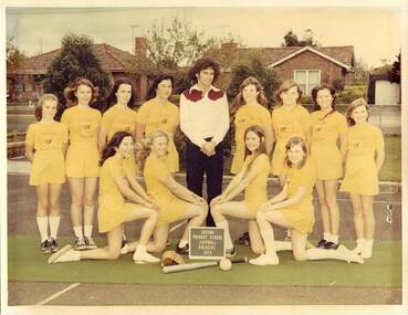
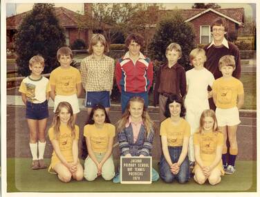
Photograph - School Photo, Jacana Primary School Bat Tennis Premiers 1979, 1979
This 1979 photograph of Jacana Primary School’s bat tennis premiers offers a nostalgic glimpse into a vibrant chapter of local school life. More than just a snapshot of sporting success, it reflects the values that underpinned the school’s ethos—participation, perseverance, and community pride. Founded in 1959, Jacana Primary served generations of families until its closure in the early 2000s, becoming a hub for both learning and local connection. The image stands as a testament to the school’s commitment to nurturing well-rounded students through both academic and extracurricular pursuits. It also serves as a cultural time capsule, capturing the spirit of a suburban Melbourne school community during a formative era in public education.This 1979 photograph of Jacana Primary School’s bat tennis premiers holds enduring cultural and historical value as a representation of the school’s commitment to holistic education and community engagement. The image is significant not only for documenting a moment of sporting achievement but also for illustrating the broader educational philosophy of the time—one that emphasised teamwork, resilience, and local pride. As a visual record from a school that served the Jacana community from 1959 until the early 2000s, it offers insight into the social fabric of suburban Melbourne during a period of growth and change. The photograph contributes to the collective memory of the area, symbolising the role of public schools as foundational institutions in shaping both individual lives and community identity.A colour photograph of Jacana Primary School’s 1979 bat tennis team. The students are dressed in various sports clothes and are arranged in rows. The teacher stands in the top right corner of the group.jacana primary school, education, photograph, group photograph, 1979, bat tennis -
 Bacchus Marsh & District Historical Society
Map, Atkins and Clarke Land Sale situate at Bacchus Marsh 1856 Copy 2
This plan of land allotments for sale indicates the property once owned by the Bacchus family in and around the township area of Bacchus Marsh. The Bacchus family sold their property in Bacchus Marsh to John Atkins and Robert Nalder Clarke in March 1851. Atkins and Clarke kept the property for a number of years until April 1856 when these allotments were put up for sale.This plan is almost identical to another copy held by the Bacchus Marsh and District Historical Society, VC Record 707, BMDHS collection). This plan, VC Record 452 Copy 2, contains a less detail than than VC Record 707 Copy 1. For example the selling agents and the surveyor who created the plan are not indicated on this copy of the plan. This copy of the plan does indicate the name Crook Street on the map. As the Crook family were the buyers of the Manor House property and surrounding land from Atkins and Clarke in 1856 it suggests that this copy is a later one of the earlier version. It is unlikely that the Crook family would have had the adjacent street named after them prior to purchasing the house and property. This is a very early land sales plan for the township of Bacchus Marsh and it therefore provides some clues as to how the early urban development of the township took place. Upon seeing the map in 1911 Bacchus Marsh Express newspaper editor Christopher Crisp wrote "The sale appears to have created the present township, which had a nucleus in earlier times further east", Express, 30 September, 1911, page 3. A single page paper map showing a portions of land available for sale in Bacchus Marsh in 1856. The subdivided land shown was owned by John Atkins and Robert Nalder Clarke, but previously owned by the Bacchus Family and was in and around their Manor House (Mansion) property in Bacchus Marsh.There are 5 portions of land further divided into numerous small portions. The land for sale is bounded by the present day streets of Main Street, Young Street, McFarland Street, Morton Streets, Crook Street, and part of the eastern section extends to the Lerderderg River. Scale: 4 chains to 1 inch. The map is pasted into a bound volume containing 76 maps or plans in total. High resolution digital image stored on BMDHS computer network. Plan of the first portion of land. The property of Messers Atkins and Clarke situate at Bacchus Marsh.land sales, land sales bacchus marsh, manor house bacchus marsh, crook family bacchus marsh -
 Melbourne Legacy
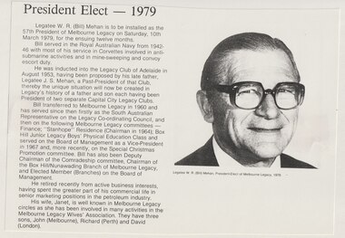
Document - Article, Legatee W R (Bill) Mehan, President 1979
A cutting from from a Melbourne Legacy President's report showing a photo of Legatee W R (Bill) Mehan (President of Melbourne Legacy in 1979). It was collected to be a record of a photo of past presidents. Legatee Bill Mehan served in the Royal Australian Navy in World War 2 with most of his service in Corvettes involved with anti-submarine activities and in mine sweeping and convoy escort duty. He was inducted into the Legacy Club of Adelaide in 1953 on the nomination of his father Legatee J S Mehan. He transferred to Melbourne Legacy 1960. The article was part of an album of past presidents from 1965 to 1989. The folder included biographical details and obituaries, eulogies and death notices of prominent Legatees. The items have been catalogued separately.A record of Legatee Bill Mehan a past president of Legacy. The information was collected to record the lives of prominent legatees in a folder.Article with a black and white photo of Legatee Bill Mehan - President 1979.past presidents, bill mehan -
 Melbourne Legacy
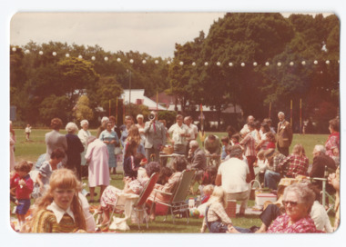
Photograph, Junior Legatee Reunion 1979, 1979
Legacy would sometimes host reunions for the children that had been cared for by Legacy over the years. The junior legatees and wards enjoyed catching up with each other and reminiscing.The junior legatees often formed lifelong friendships and reunions were an opportunity to see each other again.Colour photo of a junior legatee reunion.Handwritten on reverse 'Reunion March 1979' in black ink.junior legatee outing, reunion -
 Ringwood and District Historical Society
Photographs, 1979-80 MMBW pipe line project at Hubbard Reserve, North Ringwood � Filling behind 29 Burlock Avenue just off sewer line
Part of a 43-photo record of the MMBW�s engineering feat in drilling a 12 inch pipe line up to 40 feet deep through rock hardened by volcanic action associated with geological fault that occurs along the line. The work took place from October 1979 to May 1980 on the southern boundary of Hubbard Reserve, North Ringwood. The collection was presented to the Ringwood Historical Research Group by J Clarke on 9th June 1980.E560 N9 Dec 1979 A43 Filling behind 29 Burlock Avenue just off sewer line -
Federation University Historical Collection
Book, Ballarat School of Mines Proposed New Programs for 1979, 1979
Ballarat School of Mines is a predecessor institution of Federation University Australia. Yellow soft covered report with proposed new programs for 1979 at the Ballarat School of Mines. ballarat school of mines, courses, electric motor control, electrical drafting, camping and caravan park managers course, child care, record keeping for small businesses, introduction to sheetmetal, return to study -
 Bacchus Marsh & District Historical Society
Map, Allotments in the Village of Rowsley, Parish of Gorrocburkghap, County of Grant c.1856
Rowsley is a locality 11 kilometers south-west of Bacchus Marsh. The date of this map is uncertain. A very similar map held by the State Library of Victoria (SLV) contains slightly more information than this copy and is dated as an 1856 map. SLV reference: 'Allotments in the Village of Rowsley, Parish of Gorrocburkghap, County of Grant', by T. Nixon, Assistant Surveyor, May 1856 ; Surveyor General’s Office, July 18 1856 (lithographed by R. Meikle). (1856). Melbourne: Surveyor General’s Office. MAPS 820 BJE 1837- ROWSLEY 1856. A single page paper map. A cadastral map of the Village of Rowsley in Victoria, showing numbered land allotments. 57 allotments are shown on the map and some areas set aside as reserves. Allotments 8, and 10-16 are outlined in red ink and allotment 9 has a cross in red ink on it. The map is pasted into a bound volume containing 76 maps or plans in total. High resolution digital image stored on BMDHS computer network. rowsley victoria history, rowsley victoria maps -
Ringwood and District Historical Society
Administrative record - 2nd Ringwood (2nd Maroondah) Committee Meetings Minutes and Reports 1979-2000, Scout Association, 1979-2000
Typed reports for 2nd Ringwood (2nd Maroondah) Committee Meetings Minutes and Reports 1979-2000 -
 Federation University Historical Collection
Booklet, John Fraser, City of Ballarat 1856-1956, 1956
The Ballarat Municipality was established in 1856.Cream covered booklet covering a special meeting held to commemorate the 100th anniversary of the City of Ballarat Council. It includes a notice paper for a special meeting of Council, minutes of the Municipal Council of Ballaarat, first meeting, and images of the first survey of the Ballarat Township (1852), Ballarat in 1854, Central Ballarat in 1956, N. T. Callow and James Oddie. ballarat, council, ballarat east, ballaarat, munipality, ballarat townscape, sturt street, ballarat survey, yarrowee, paroompi, parmoompi, diggings -
 Bacchus Marsh & District Historical Society
Map, Plan of the property of Messers Atkins and Clarke to be sold at the Mansion, Bacchus Marsh 19th April 1856. Copy 1
This plan of land allotments for sale indicates the property once owned by the Bacchus family in and around the township area of Bacchus Marsh. The Bacchus family sold their property in Bacchus Marsh to John Atkins and Robert Nalder Clarke in March 1851. Atkins and Clarke kept the property for a number of years until April 1856 when these allotments were put up for sale.This plan is almost identical to another copy held by the Bacchus Marsh and District Historical Society, VC Record 452, BMDHS collection). This plan, VC Record 707 Copy 1, contains a little more detail overall than VC Record 452 Copy 2, such as who did the survey work for the plan (R.C. Bagot) and who the selling agents were, (W.M. Tennent), and on the right side of the plan near the Lerderderg River is indicated the general area for a second parcel of land from this sale which is to be sold. There is also a compass illustration indicating north and south compass points.This is a very early land sales plan for the township of Bacchus Marsh and it therefore provides some clues as to how the early urban development of the township took place. Upon seeing the map in 1911 Bacchus Marsh Express newspaper editor Christopher Crisp wrote "The sale appears to have created the present township, which had a nucleus in earlier times further east", Express, 30 September, 1911, page 3.A single page paper plan showing allotments of land for sale. The subdivided land shown was owned by John Atkins and Robert Nalder Clarke, but previously owned by the Bacchus Family and was in and around their Manor House (Mansion) property in Bacchus Marsh.There are 5 portions of land further divided into numerous small portions. The land for sale is bounded by the present day streets of Main Street, Young Street, McFarland Street, Morton Streets, Crook Street, and part of the eastern section extends to the Lerderderg River. Scale: 8 chains to 1 inch The plan is pasted into a bound volume containing 76 maps or plans in total. BMDHS Loc: AR/B12/S4 Bacchus Marsh Township and Nearby Districts Maps Volume In-house Digital copies: BMDHS, Computer Network: Maps\Bacchus Marsh Township and Nearby Districts Maps VolumeHeading: Plan of the first portion of land. The property of Messers Atkins and Clarke situate at Bacchus Marsh. To be sold by W.M. Tennent & Co. at the Mansion on the Ground on Saturday the 19th April 1856. Below heading: Jas Ferguson, Lithographer On upper right side: Subdivided by R.C. Bagot London and Liverpool Chambers, Melbourne. 'Thos Taubman'. Post Office Stamp: BACCHUS MARSH VICTORIA MY 6, 63bacchus marsh victoria maps, bacchus family, land sales, manor house bacchus marsh