Showing 3807 items matching "1890s-1930s"
-
 Wonga Park Community Cottage History Group
Photograph (Item) - Black and White, Wonga Park: The Oaks, 1930s, c. 1931
Wonga Park: The Oaks 1930sPhoto is named 14880028.jpg on CD -
 Greensborough Historical Society
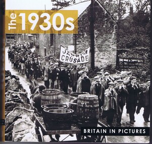
Book, Ammonite Press, The 1930s: Britain in Pictures, 2012
Picture book with photos and text of Britain in the 1930sSoft Covered book with black and white pictures and textbritish history, photographs, history, great britain -
 Surrey Hills Historical Society Collection
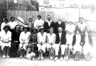
Photograph, Tennis Club, Durham Road area, 1930s
The club was located at the south end of Durham Road, Surrey Hills in the 1930s. Black and white photo of members of a tennis club. There are 18 people in the photo - 10 adult females, 4 adult males, 3 younger males and a small dog; 6 females and 2 males are holding tennis racquets. There is a wicker baby's pram behind the group and in the background are the backs of houses.Top in biro in Jocelyn Hall's hand: "For Neighbourhood Centre" then below: "App. 1930" At the bottom in grey pencil: "TENNIS CLUB (BOTTOM OF DURHAM RD) / BACK OF HOUSES IN THAMES ST."tennis, sports and recreations, thames street, durham road, w prewett -
 Eltham District Historical Society Inc
Document - Map, Doug Orford, Main Road, Eltham (c..1930s-1970s), c.2010
Map of Main Road with listings of all properties (shops/homes) from Mount Pleasant Road through to Pryor Street from the 1930s on to about the 1970sandrew store, andrews newsagency, arthur street, babe taylor house, bakery, barbers blue gum store, blue gum, boarding house, bootmakers cottage, bottle shop, bradford butcher shop, bradford house, bradley house, brdbury house, bridge street, brooker, brougham steet, brown blacksmith, browne's grocer, bryant, burgoyne post office, burgoyne's shop, capewell butcher shop, catholic church, catholic school, chandlers lolly shop, cheddar black, chiropractor, cockcroft, commercial bank of australia, copelands chemist, copelands dairy, d. hall house, dave lyon house, david lyon house, dr cordner, dr loosli, dr r. bradbury, dudley street, eltham, eltham bakehouse, eltham courthouse, eltham fire brigade, eltham living and learning centre, eltham pre-school, eltham railway station, eltham shire office, eltham station masters house, eltham war memorial, f. collis store, feed store, fountain hotel, franklin street, gadd's blacksmith, gahan house, garnet burges, george bird grocer, gollings, grant house, harry hawker, headmaster's resience, henry street, hepburn house, hills house, isherwood house and shop, jack ryan, jack shallard, james house, jarrold cottage, jim ryan, john lyon house, kilpatrick, le brocq, leather and harness, len parsons, lock-up, lyon bros garage, main road, map, mathews house, mclean's produce store, mechanics institute, methodist church, methodist hall, milkbar, mills bootmaker, miss george, monteith house, mount pleasant road, mrs bradbury, mrs davis house, mrs jewell, mrs mbremner store, mrs morris shop, napoleon street, obelisk, panther place, peter gahan, pitt street, plumber, police residence, poultry and market garden, pryor street, railway house, rains newsagency, real estate agent, reeves general store, s. bradbury, shillinglaw cottage, staffs general store, stones mixed shop, tennis court, timber yard, w. walker, w.b. andrew corn store, warren's general store, water trough, watsons hotel, websters house, whitecloud cottage, whites general store, williams bootmaker, wingrove cottage, wingrove park, woodyard, york street, franco and co -
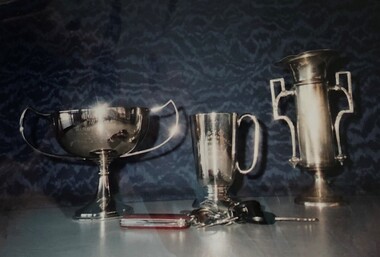 Royal Brighton Yacht Club
Trophy, 1930s Trophies
1930s Trophies Donor: Deed of Gift: Details: Left to Right A1 Class ‘Acrospire’ 1936 Young Frothblowers Corella 1930 Corella and Royalist 1930/ 34 a1, acrospire, frothblowers, corella, royalist -
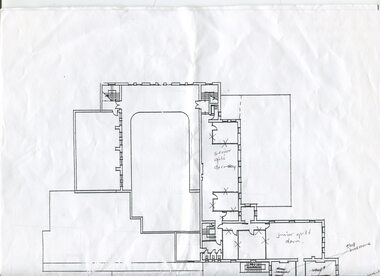 Vision Australia
Plan - Image, 1920s and 1930s Room Allocation at RVIB, 1981-2004
Plans of the RVIB building in St Kilda Road, with handwritten annotations regarding their usage in the 1920s and 1930s. Recollections come from a discussion between David Ditchfield and Michele Prentice. Copy sent to Faye Woodhouse from Allom Lovell and Associates for the Conservation Management Plan.3 floor plans on A3 pages with handwritten notesAllom Lovell + Assocroyal victorian institute for the blind, plans, david ditchfield -
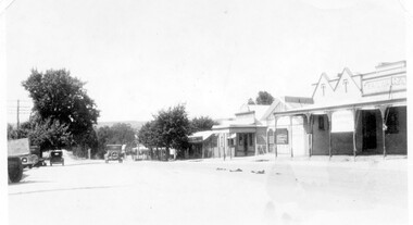 Linton and District Historical Society Inc
Photograph, Sussex Street, Linton - view to north, late 1920s or early 1930s
Dated to late 1920s or early 1930s as Nelson building has been renovated as a Californian bungalow. The earlier curvilinear parapet on the library building (see photo - Registration no. 166) has been squared off, and a small pedimented timber parapet has been added above.Black and white photograph of Linton's main street, Sussex Street. View of Railway Hotel, Nelson undertaker building, public library and "cash emporium". Cars parked and driving along Sussex St."Linton Main Street".sussex street linton, railway hotel, nelson undertakers, linton public library, cash emporium, transport, cars -
 Greensborough Historical Society
Notebook - Digital Image, David Medhurst's notebook, 1930s, 1930-1932
David Medhurst (senior) ran a fruit shop in Grimshaw Street Greensborough and also reported on local events for the Hurstbridge "Advertiser" during the 1930s. This notebook, in the collection of his descendants, contains newspaper clippings of his articles and handwritten notes detailing payment for his work. The page shown is an example only; there are 54 similar pages in the collection.The importance of these clippings lies in their clarity as some copies on the Trove database are almost illegible.They also provide a snapshot of life in the 'rural' township of Greensborough in the 1930s.Scanned copy of 54 pages of handwritten notes and pasted newspaper clippings.Hand written notes throughout.david medhurst, hurstbridge advertiser -
 Eltham District Historical Society Inc
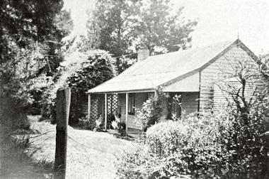
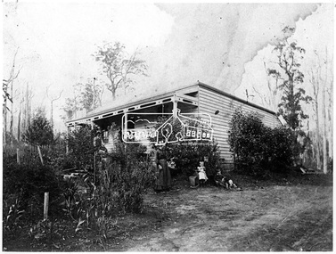
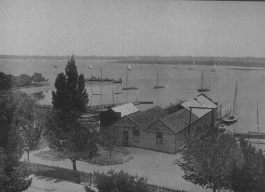
Photograph, First Post Office at "The Oaks", Kinglake, 1890s
Source: Mrs. McMinn, Kinglake Cross Ref: SEPP_0002 and SEPP_0005This photo forms part of a collection of photographs gathered by the Shire of Eltham for their centenary project book,"Pioneers and Painters: 100 years of the Shire of Eltham" by Alan Marshall (1971). The collection of over 500 images is held in partnership between Eltham District Historical Society and Yarra Plenty Regional Library (Eltham Library) and is now formally known as the 'The Shire of Eltham Pioneers Photograph Collection.' It is significant in being the first community sourced collection representing the places and people of the Shire's first one hundred years.Digital imagesepp, shire of eltham pioneers photograph collection, kinglake, the oaks, post office -
 Eltham District Historical Society Inc
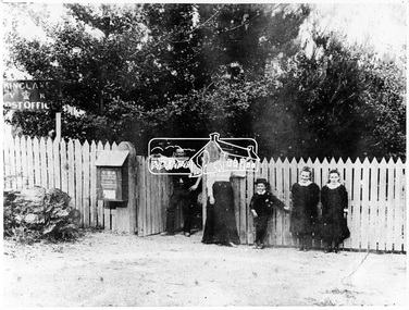
Photograph, At "The Oaks", Kinglake, 1890s
Source: Mrs. McMinn, Kinglake Cross Ref: SEPP_0002 and SEPP_0003This photo forms part of a collection of photographs gathered by the Shire of Eltham for their centenary project book,"Pioneers and Painters: 100 years of the Shire of Eltham" by Alan Marshall (1971). The collection of over 500 images is held in partnership between Eltham District Historical Society and Yarra Plenty Regional Library (Eltham Library) and is now formally known as the 'The Shire of Eltham Pioneers Photograph Collection.' It is significant in being the first community sourced collection representing the places and people of the Shire's first one hundred years.Digital imagesepp, shire of eltham pioneers photograph collection, kinglake, the oaks -
 Ringwood and District Historical Society
Document - Envelope, Packet: Historical Recollections Ringwood in the 1890s; brief history; Clippings. Introduction by Gerry Robinson 2007
Handwritten and typed notes on brief history of Ringwood with slides and newspaper cuttings - 90 pages -
 Ringwood and District Historical Society
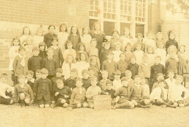
Photograph, State School, Ringwood No 2997 Grade 1&2 Students incl (undated) c early 1890s?
Poor Quality Photo, but can identify as Grade 1&2. No year given. Porbably early 1890's according to Evlie Dobbin school register entry. Written on back of photograph, "Elvie Dobbin. State School, Ringwood No 2997". -
 City of Moorabbin Historical Society (Operating the Box Cottage Museum)
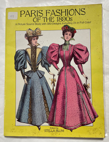
Book, Blum, Stella, Paris Fashions of the 1890s, 1984
A picture source book with 350 designs, including 24 in colourA picture source book with 350 designs, including 24 in colournon-fictionA picture source book with 350 designs, including 24 in colourfashion, france, paris, history, dress -
Port Melbourne Historical & Preservation Society
Document - Photocopy, maps, 1890s maps, 30 April 1890 .01 11 March 1890 .02
.01 Copy of Map 3084B - Port Melbourne, Willamstown Road to Esplanade East; to Graham Street; to Boundary Road & Pickles Street. .02 Copy of map of Port Melbourne, Bay Street to Clark Street; to Foreshore; to Pickle Street & Spring Street..01 for title information see parcels index 47,53,54,55,56 & 57. .02 Parcels index 3084-B 16 (City of Port Melbourne)built environment - commercial, built environment - domestic, city of port melbourne, parish of south melbourne -
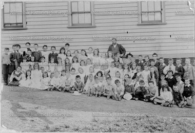 Nillumbik Historical Society Incorporated
Photograph - Black & white photograph, Diamond Creek State School 1890s
Black & white photographnillumbik school, diamond creek -
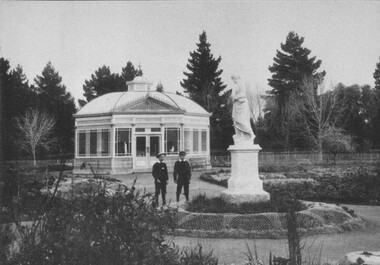 City of Ballarat Libraries
Postcard - Photograph, The Statuary Pavilion, Ballarat Botanic Gardens circa 1890s
Children look at a statue near the Statuary Pavilion at the Botanic Gardens.statuary pavilion, botanic gardens, statues -
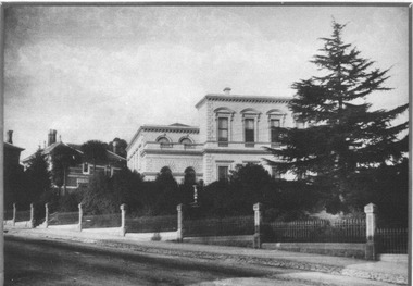 City of Ballarat Libraries
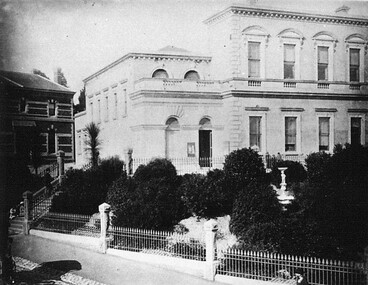
Photograph, East Ballarat Town Hall & Court House circa 1890s
The East Ballarat Town Hall & Court House stood in Barkly Street. The library can be seen in the background.east ballarat town hall, barkly street, library, buildings -
 City of Ballarat Libraries
Photograph, Boat Harbour, Lake Wendouree circa 1890s
The boat harbour on Lake Wendouree was situated on the eastern side.lake wendouree, rowing, ballarat, harbour, entertainment -
 City of Ballarat Libraries
Photograph, View of Lake Wendouree from Fry's Mill circa 1890s
This view from Fry's Mill is of the eastern side of the lake.lake wendouree, fry's mill, ballarat -
 City of Ballarat Libraries
Photograph, View from the Post Office Tower of the Town Hall and Cab Rank, Sturt Street Ballarat circa 1890s
Paterson Laing & Bruce Cab Rank in the median strip of Sturt Street which is still yet to be formed with few trees. Notice the flag at half mast.sturt street, post office, town hall, cab rank, paterson laing -
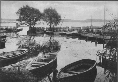
 City of Ballarat Libraries
Photograph, Lake Wendouree & Paddle Steamer Shed circa 1890s
The Paddle Steamer Shed was located on the eastern side of Lake Wendouree.lake wendouree, paddle steamer, boat shed, building -
 City of Ballarat Libraries
Photograph, Ballarat Botanic Gardens Fernery circa 1890s
This photo shows the Fernery and Curator's House at the Ballarat Botanic Garden.garden, building, ballarat, botanic gardens, fernery, curator's house, statue -
 City of Ballarat Libraries
Photograph, Gill's Boat Shed, Lake Wendouree circa 1890s
Thomas Gill Boat Builder and Golden Steamer Boat Shed. thomas gill, golden steamer, boat sheds, lake wendouree, commerical, manufacturing -
 City of Ballarat Libraries
Photograph - Card Box Photographs, East Ballarat Town Hall & Court House circa 1890s
east ballarat town hall, east ballarat court house, gardens, building, public -
 Buninyong & District Historical Society
Equipment - Colour photograph, Stirrups belonging to Constable Power, Buninyong, 1890s, 19th Century
Stirrups belonging to Constable John James Power of the Victorian Mounted Police, who served at Buninyong between 1893 and 1900.Historically significant as an item of equipment issued to Victorian mounted police in the colonial eraPair of nicklesilver stirrips issued to Victorian police in colonial Victoria. Engraved with number "4105"police, law and order, horses, power j.j., buninyong -
 Bacchus Marsh & District Historical Society
Map, Coimadai Parish Map, County of Bourke. Circa 1890s-1900s
The cadastral Parish of Coimadai, a subdivision of the County of Bourke, lies directly north of the township of Bacchus Marsh. The date of this map is uncertain. T.F. McGauran the person who made a photo-lithographic copy of the map was in charge of photo-lithography at the Victorian Department of Lands and Survey in the late 19th century until about 1910.A single page paper map showing the map for the Parish of Coimadai in the County of Bourke. A cadastral map showing parish boundaries and land ownership. A rectangle shaped area is missing from the centre of the map due to a tear or deliberate excision. The map is pasted into a bound volume containing 76 maps or plans in total. High resolution digital image stored on BMDHS computer network. Photo-lithographed at the Department of Lands and Survey, Melbourne by T.F. McGauran 26.8.[??] NOTE. Photo litho from L.P showing temporary surveys and occupation of land prepared for departmental use onlybacchus marsh region parish plans, coimadai parish maps, coimadai parish plan -
 Bacchus Marsh & District Historical Society
Map, Gaynor Street Land Sales, Maddingley, circa 1880s-1890s
This map was produced for a major sale of land in the Maddingley area of Bacchus Marsh. The precise date of the sale has not been determined. Features present on the map such as the Bacchus Marsh Railway Station indicate the land sale must have taken place some time after 1887 when the Railway Station opened. A single page paper map showing land allotments for sale in the Maddingley area of Bacchus Marsh. Locations shown include Gaynor Street, Maddingley Road South, Parwan Road, Mitchem Street, Typpynge Street, Finn Street and East Maddingley Road. . The map is pasted into a bound volume containing 76 maps or plans in total. High resolution digital image stored on BMDHS computer network. bacchus marsh victoria maps, maddingley victoria maps, land use, maddingley victoria history, land sales bacchus marsh, land sales maddingley -
 Buninyong Visitor Information Centre
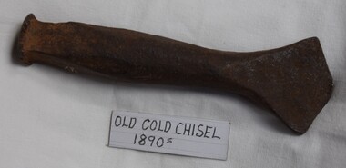
Tool - Cold Chisel, 1890s Cold Chisel
Short, heavy metal tool with fan-shaped working end.metalwork, chisels, tools -
 Bacchus Marsh & District Historical Society
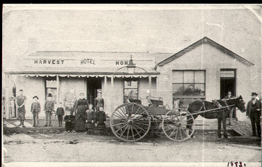
Photograph, Harvest Home Hotel Main Street Bacchus Marsh c.1880s-1890s
The Harvest Home Hotel was licensed as a beer shop in 1866. Patrick Vallence was the licensee. On his death in 1874 his widow Mrs M. A. Vallence obtained the license. The date that this image was created has not been identified. Around 1883 George Marshall was leasing the hotel. The people in this image are could be members of the Marshall family and some of the staff who worked in the hotel at this time. Following a decrease in the population of Bacchus Marsh by 1911 the hotel had lost its licence. The Vallence family still owned the building after the loss of the hotel license in 1911and it was used for some years after this as a private residence by some members of the Vallence family. Small black and white photograph. The image depicts the Harvest Home Hotel situated in Main Street Bacchus Marsh. The name of the hotel can be seen above the verandah roof. The building appears to be of stone with decorative stonework corners. A verandah is inset to the left of a gabled front section which has its own door and window. A deep gutter runs along the front of the hotel, with a slab acting as a bridge to the road. Standing in front of the building facing the camera is a group of adults and children, men and women and boys and girls. A four seated buggy drawn by a single horse is also present in the image. The lantern erected above the horse trough can be seen.hotels bacchus marsh, vallence family bacchus marsh, marshall family bacchus marsh, harvest home hotel bacchus marsh -
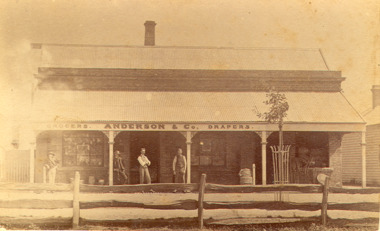 Bacchus Marsh & District Historical Society
Photograph, Anderson's Store, Main Street, Bacchus Marsh circa 1870s-1890s
This store in Main Street Bacchus Marsh was first opened by James Young in November 1866. In October 1869 it was purchased by William Anderson and was operated by members of the Anderson family until 1971. The site of the store was on the southern side of Main Street on the eastern side of Eddie Toole Park. On the opposite side of the street was the site of the former Post Office on the northern side of Main Street. The store was first named the Border Mills Store during James Young's ownership and was later known as the Border Store (Anderson & Co.).Small black and white photograph showing Anderson’s store. It shows a large stone building with a corrugated iron verandah which bears a painted sign of the name of the business: GROCERS. ANDERSON & Co. DRAPERS. Behind a brick parapet rises a hip roof with one chimney visible. Four men stand in casual poses ranged along the verandah. A post and rail fence runs along the road frontage. A tree is planted in an ornamental wrought iron plant protector on the inside of the fence.On the back in decorative print: “ New York Photographic Adelaide Travelling Brand Chas. F. Husband Manager.” In handwriting: Border store built by James Young 1866 owned by Anderson 1869-1972. BMDHS stamp and no. HS 411.shops bacchus marsh vic., anderson's store bacchus marsh, stevenson and mcnicoll 1883 photographs of bacchus marsh and district