Showing 127 items matching "bay view house"
-
 Glenelg Shire Council Cultural Collection
Photograph, View of Lady Bay reclaimation and Pivot Fertiliser Works, 21/03/1972
Port of Portland Authority archives.Front: (no inscriptions) Back: (no inscriptions)port of portland, lady bay, pivot fertiliser works -
Glenelg Shire Council Cultural Collection
Photograph, View across North Portland to Bridgewater Bay, 1968
Port of Portland Authority archives.Front: (no inscriptions) Back: LOOKING ACROSS NORTH PORTLAND TOWARDS BRIDGEWATER BAY JULY. 1968port of portland, bridgewater bay, wool stores -
Glenelg Shire Council Cultural Collection
Postcard - Postcards - Cape Bridgewater Bay, n.d
2 black and white photo postcards, 'Rose' series. View of Cape Bridgewater from the beachFront: 'THE ROSE SERIES, P.1121 COPYRIGHT' 'DISCOVERY BAY, PORTLAND, VICTORIA' - bottom border printed Back: Maker's details, logo -
Glenelg Shire Council Cultural Collection
Postcard - Postcard - Blowholes, Cape Bridgewater Bay, Victoria, n.d
Black and white photo postcard, Rose series. View of the blowholes at Cape BridgewaterFront: 'THE ROSE SERIES, P1118 COPYRIGHT'. 'THE BLOW-HOLE, CAPE BRIDGEWATER, NEAR PORTLAND VIC.' bottom border printed Back: Handwritten message -
Glenelg Shire Council Cultural Collection
Photograph - Photograph - Bridgewater Bay, Bridgewater Victoria, n.d
Black and white photo. View from beach across bay, Cape Bridgewater in distance.Back: 'Cape Bridgewater in distance. View of beach' - handwritten, black ink Round purple stamp 'PRINTED BY M.E. ANDREWS PORTLAND'bridgewater bay -
Glenelg Shire Council Cultural Collection
Photograph - Photograph - Cape Bridgewater, n.d
Black and white photo. View from top of hill at Bridgewater, looking across the bay towards Cape Nelson.Back: '56' in pencilcape bridgewater, cape nelson, seascape -
Glenelg Shire Council Cultural Collection
Souvenir - Souvenir - Tea Towel Portland, Maretimo, 1977
Pure linen printed souvenir tea towel (black and green on ecru); Showing two views of Maretimo (Portland) and a map of its location in relatio to Portland Bay. Care label states designed in Australia, made in Hong Kong. -
Glenelg Shire Council Cultural Collection
Photograph - Sheet of 2 contact prints from glass plate negatives, 1960-1970
Sheet of 2 contact prints from glass plate negatives. Top: S.S. Eumeralla berthed at Ocean pier. View towards Portland. Bottom: Flat rocks at base of cliffs Bridgewater Bay. -
Glenelg Shire Council Cultural Collection
Photograph - Sheet of 12 contact prints - Various historic Portland buildings and Landmarks, c. 1970
Sheet of 12 contact prints of rephotographed photographs. Identifying numbers 5724 a, b, c, d, e, f, g, h, i, j, k, l (a) First jetty and immigration depot (b) National School (c) Observatory Hill (d) 'Kenley" Res. George Crouch, First Post Master (e) Old Library (f) Union (ANZ) Bank (g) Lighthouse and Keepers Cottage (h) 'Blainslie' (i) View from Whalers Bluff over Bay (j) Percy Street, view from Henty Street (k) Portland Jail (l) Flagstaff and Light Keepers quartersFront: (a) Henty Beach (b) Portland State School (c) Old Library (f) ANZ Bank (i) View of Whalers Point (k) Portland Jail on Observatory Hill -
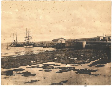 Flagstaff Hill Maritime Museum and Village
Photograph - Coastal Scene, Joseph Jordan Photographic Studio, Lady Bay and Breakwater, Warrnambool, circa 1907
The Port of Warrnambool - In the early years the Port of Warrnambool was a busy port. Steamships and sailing ships were frequent visitors to the port. Steam navigation companies were plentiful, carrying passengers and freighting cargo such as coal, timber, food, livestock, furniture, hardware and haberdashery between Melbourne and the ports along the southwest coast of Victoria, including Warrnambool. The carts would take their loads into the township for distribution. The Breakwater was built (using 32 ton blocks of concrete) between 1874 and 1890 to provide ships with greater protection from the Southern Ocean. The Lifeboat and Rocket House - The coastline of South West Victoria has had over 600 shipwrecks and many lost lives; even in Warrnambool’s Lady Bay there were around 16 known shipwrecks between 1850 and 1905, with eight lives lost. In 1859 the first Government-built lifeboat arrived at Warrnambool Harbour and a shed was soon built to house it, followed in 1864 by a rocket house to safely store the Rocket Rescue equipment. In 1878 the buildings were moved to the Breakwater area, and in 1910 the new Lifeboat Warrnambool arrived with its ‘self-righting’ design. For almost one hundred years the lifeboat and rocket crews, mostly local volunteers, trained regularly to maintain and improve their skills, summoned when needed by alarms, gunshots, ringing bells and foghorns. Some became local heroes but all served an important role. By the end of the 1950s the lifeboat and rescue equipment had become obsolete. Joseph Jordan - Joseph Jordan was born in 1841 in Leicester England. When he was 16 he joined the 7th Queen's Own Hussars and was sent to India at the outbreak of the mutiny. He took part in the relief of Lucknow and remained in India for eleven years. It was during this time, he became interested in photography. He was posted to New Zealand and later came to Victoria, becoming a sergeant major of the Mounted Rifles. In the mid 1880s he came to the Western district where he was responsible for establishing units of the Mounted Rifles in various country towns such as Dunkeld, Mortlake, Panmure, Bushfield, Koroit etc. He resigned from the army in 1889 and set up a professional photography studio in Liebig Street, Warrnambool. He became very well known in the Western District for family photographs, official photographs of local councillors and groups as well as views of local scenery. In 1891 he photographed the wrecked barque "Fiji" at "Wrecks Beach" near Princetown. His business was taken over by his son Arthur around 1917. Joseph was a keen rifle shot and in 1924 he donated the "Jordan Shield" as a prize to the Victorian Rifle Association. He was made a "Life Honorary Member" of the Warrnambool Returned Soldiers League and in 1933 he was recognised as being the oldest living soldier in Victoria. Joseph died in 1935 aged 95.This photograph is significant for its association with the Port of Warrnambool and the Warrnambool Breakwater as it shows a point in time when shipping activities were an important part of Warrnambool's commerce and social development. It is also a record of the Warrnambool Lifeboat and Rocket house which was important in aiding ordinary citizens, harbour employees and the volunteer boat and rescue crew in saving the lives of sailors and passengers due to the high number of shipwrecks that occurred along the coastline. Joseph Jordan is a significant figure in Warrnambool history as he helped to establish early units of the Mounted Rifles (G Company) in local towns during the late 1880's and later, photographed local scenes, groups and citizens of early Warrnambool. Sepia photograph showing the beach and the Breakwater in Lady Bay Warrnambool, two ships (a steamship and a barque), a small sailboat, and the Lifeboat and Rocket House plus two smaller sheds.Front of photo - BREAKWATER, WARRNAMBOOL, VICTORIA Back of photo - "From: P Gregory / 365 Beach Road / BLACK ROCK 3193"flagstaff hill, flagstaff hill maritime museum, warrnambool, warrnambool harbour, port of warrnambool, tramway jetty, breakwater, lifeboat and rocket shed, steamship, barque, photograph of lady bay, rocket house, shipping, joseph jordan, lady bay, views of warrnambool, jordan photography -
 Eltham District Historical Society Inc
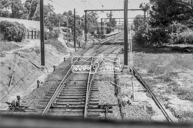
Photograph, George Coop, Approaching Eltham Railway Station from Diamond Creek, 6 December 1980, 1980
View from driver's cabin The Station Master's house is located within the cluster of trees to the left of the photograph which is now the short term car park and bus bay. The Country Art Store is now Cafe 3095.Digital TIFF file Scan of 35mm Ilford FP4 black and white transparencycountry art store, eltham railway station, eltham station masters house -
 Glen Eira Historical Society
Album - Album page, Hotham Street, Circa 1972
This photograph is part of the Caulfield Historical Album 1972. This album was created in approximately 1972 as part of a project by the Caulfield Historical Society to assist in identifying buildings worthy of preservation. The album is related to a Survey the Caulfield Historical Society developed in collaboration with the National Trust of Australia (Victoria) and Caulfield City Council to identify historic buildings within the City of Caulfield that warranted the protection of a National Trust Classification. Principal photographer thought to be Trevor Hart, member of Caulfield Historical Society. Most photographs were taken between 1966-1972 with a small number of photographs being older and from unknown sources. All photographs are black and white except where stated, with 386 photographs over 198 pages.Victorian Heritage Database - Hotham Street Road Overbridge HO116 Heritage Overlay - City of Glen Eira https://vhd.heritagecouncil.vic.gov.au/places/43557 (as of 04/07/2021) The Hotham Street road overbridge is located on the Sandringham railway line between Ripponlea and Elsternwick railway stations. It is presumed to have been built by contractors Sharp and Campbell who signed a contract on 25th . November, 1881 to construct a second line of railway between Windsor and Elsternwick. This contract was completed during 1882 and the bridge may have been designed in the year when Robert Watson took over from William Elsdon as engineer in chief for the Victorian railways. It is historically, aesthetically and technically significant. It is historically significant (Criterion A) to the extent that it demonstrates the standards of construction adopted by the Victorian Railways Department when it rebuilt the lines acquired from the private railway companies, (compare the Geelong and Melbourne Railway Co's line from Newport to Geelong, acquired in 1860). It is aesthetically significant (Criterion E) as an intact nineteenth century structure of its type, many similar girder bridges having been renewed with concrete girders in recent years. The bluestone abutments demonstrate high standards of stone masonry and are representative of Departmental work of the period. This bridge forms one of a group of historic structures on the railway to Brighton Beach and therefore contributes to the line's cultural importance as a whole. The survival of the riveted iron girders with their bellied angle iron struts is important since these elements are representative of the civil engineering practices of the Victorian Railways at the time and constitute the technical significance (Criterion F) of the structure.Page 96 of Photograph Album with three photographs (one portrait and two landscape) from Hotham Street - two external views of one house and a railway bridge.Handwritten: Hotham Street [top right] / 112 HOTHAM ST [under top left photo] / BRIDGE OVER SANDRINGHAM RAILWAY [under top right photo] / 112 HOTHAM ST CNR MELBY AVE [under bottom left photo] / 96 [bottom right]trevor hart, elsternwick, hotham street, caulfield, houses, brick, bay windows, verandahs, railway bridges, tunnels, gardens, bluestone, civil engineering, victorian railways, sharp and campbell, contractors -
 Glen Eira Historical Society
Album - Album page, Lirrewa, 1-3 Lirrewa Grove, Circa 1972
This photograph is part of the Caulfield Historical Album 1972. This album was created in approximately 1972 as part of a project by the Caulfield Historical Society to assist in identifying buildings worthy of preservation. The album is related to a Survey the Caulfield Historical Society developed in collaboration with the National Trust of Australia (Victoria) and Caulfield City Council to identify historic buildings within the City of Caulfield that warranted the protection of a National Trust Classification. Principal photographer thought to be Trevor Hart, member of Caulfield Historical Society. Most photographs were taken between 1966-1972 with a small number of photographs being older and from unknown sources. All photographs are black and white except where stated, with 386 photographs over 198 pages.From Victorian Heritage Database citation for - HO39 Tarqua and Stables, 1-3 Lirrewa Grove Caulfield South https://vhd.heritagecouncil.vic.gov.au/places/120932 as at (26/10/2020) "Tarqua", now "Lirrewa", is situated at nos. 1-3 Lirrewa Grove, Caulfield South, and was built in 1886 for Montague William Langdon, son of the merchant Joseph Henry Langdon of nearby "Rosecraddock". It is historically and aesthetically significant. It is historically significant (Criterion A) as one of the Langdon family residences, comparing in Glen Eira also with "Rosecraddock" at 10 Craddock Avenue (1857) and "Hengar" at 356 Glen Eira Road (1889-90). It is aesthetically significant (Criterion E) for its capacity to demonstrate the stylistic influences prevailing at the time especially for substantial residences. At "Tarqua", the design acknowledges the prevailing popularity of the Italian Style in the shallow hipped roof form and symmetrical facade as well as the picturesque Gothic Revival style demonstrated especially by the use of pointed arches, fretted barges and the battlemented parapeted section. This latter style was particularly attractive to persons of means on account of its English precedents, the combination of influences being skillfully handled in this instance.Page 121 of Photograph Album with one landscape photograph of Lirrewa - external view of a bay window.Handwritten: Lirrewa [top left ] / 121 [bottom left]trevor hart, verandah, lirrewa, tarqua, 1880's, montague william langdon, italian style, shallow hipped roof, symmetrical facade, gothic revival, pointed arches, fretted barges, battlemented parapet, ornamented parapets, terraces, boom era, timber roof brackets, frieze, gables, cast iron ridging, lirrewa grove, bay window, cast iron work, lead lights, houses, victorian style, caulfield, caulfield south -
 Glen Eira Historical Society
Album - Album page, Booran Road, 30, Circa 1972
This photograph is part of the Caulfield Historical Album 1972. This album was created in approximately 1972 as part of a project by the Caulfield Historical Society to assist in identifying buildings worthy of preservation. The album is related to a Survey the Caulfield Historical Society developed in collaboration with the National Trust of Australia (Victoria) and Caulfield City Council to identify historic buildings within the City of Caulfield that warranted the protection of a National Trust Classification. Principal photographer thought to be Trevor Hart, member of Caulfield Historical Society. Most photographs were taken between 1966-1972 with a small number of photographs being older and from unknown sources. All photographs are black and white except where stated, with 386 photographs over 198 pages. From Glen Eira Heritage Management Plan 1996 by Andrew Ward: In 1888, John Leek, a trainer, owned Lot 15, measuring one and three quarter acres, in Booran Road, north side between Glen Eira and Neerim Roads. The land backed onto the Caulfield Racecourse Reserve. NAV was £45. In 1890 Leek built for his residence, a ten roomed brick house on the site. NAV was £200. Leek was the owner/trainer of "Ingliston" who won the Caulfield Cup in 1900. Upon the horse's death in 1901, Leek is understood to have defied tradition by spending £20 on boots for the "ragged urchins in Bourke Street" instead of "shouting" at the bar. By 1899, the property was owned and occupied by Alfred Merrill, a dentist and was known as "Andover". NA V had decreased to £ll0. By 1910, Leslie Macdonald, a gentleman had purchased the property and renamed it "Moidart". In 1910-11 Macdonald sold it to John Robertson. The property had extensive wood stables on its north-east boundary and several other outbuildings. The house continued to be described as "Brick, ten rooms" as it was in 1926 when it was owned and occupied by John Arthur, a managing director. The land measured la.2r.31p. and had a NAV of £235. Nine people lived there. In 1926, Arthur also owned the adjoining Lot 16. Other racehorses of note, known to have been stabled here include Sobar, Havelock, Proud, Future and Lord.Victorian Heritage Register https://vhd.heritagecouncil.vic.gov.au/places/13532 What is significant? Lord Lodge is a thoroughbred racehorse training complex adjacent to Caulfield Racecourse, established in 1890. The area immediately around the racecourse has been associated with horse racing activities and businesses servicing the industry since the development of the racecourse in late the 19th century. Lord Lodge was named by the present occupants after the champion racehorse Lord who was stabled there in the 1950s. In the early 20th century the property was known as 'Andover' and subsequently 'Moidart'. The site consists of a single storey brick Italianate villa, jockeys' quarters, stables and open day yards with direct access to Caulfield racecourse from the rear of the property. The villa of 10 rooms on bluestone foundations was constructed in 1890 by John Leek, a horse trainer who purchased the newly subdivided land in 1888. The house has many Victorian Italianate or Boom Style features although it is more modest than many villas of its style. It has an asymmetrical facade with a faceted bay window and a prominent central tower with low pitch pyramidal roof that provides a clear view of the racecourse. Other characteristic features include stilted segmented arches, bracketed eaves, stucco wall finish and cast cement ornamentation. A room has been added on the north-facing verandah in sympathetic style and finish. Internally the rooms are substantially intact with original marble fireplaces and intricate ceiling roses and cornices. An entrance toward the rear of the southern side of the house is said to be where the stable hands, jockeys and other staff lined up for their meals. In the southeast corner of the property, backing directly on to Caulfield racecourse, is a substantial late Victorian timber stable, probably constructed in the 1890s but first appearing on the property title in 1910. The stable has 12 stalls, a loft and brick pavement and jerkin head roof form with varnished pine-lined ceiling carried on a chamfered timber frame. It has an original roof lantern. The doors of the stalls are not the original sliding doors but swing doors obtained from a barn at Epsom Racecourse in Mordialloc prior to demolition. Outside the gambrel roof has fretted barges but the building is otherwise utilitarian. Timber throughout the stalls has been worn by chewing and rubbing of horses over the century of its use. In the southern half of the property are open day yards where the racehorses are kept during the day. The red brick, single storey jockeys' quarters to the rear of the villa were probably built around 1950. A small brick, possibly late Victorian structure on the eastern boundary thought to have originally been a gardening shed, has been converted to a stable of two stalls. Modern concrete brick stables fill the northeast portion of the property. At the front of the property two Moreton Bay Figs (Ficus macrophylla), probably planted in the late 19th century, provide shade for horses in the day yards. In the 1890s John Leek sold the property, relocating his training facility to one of the newly established racecourses at Mentone or Mordialloc (Epsom). By 1899, the property was owned and occupied by Alfred Merrill, a dentist, who named the property 'Andover'. In 1910 it was purchased by Leslie McDonald, a gentleman, and renamed 'Moidart'; sold in 1910-1911 to John Robertson; and again in 1926 to John Arthur, a racehorse owner. The Victorian Amateur Turf Club purchased the property in the late 1930s and since this time has been leased to racehorse trainers. It is unclear whether the property operated as a training facility between 1899 - 1926. Several notable trainers and jockeys are associated with Lord Lodge. The best known is Arthur 'Scobie' Breasley, Australia's most successful jockey who was apprenticed to trainer Pat Quinlan at Lord Lodge (then 'Moidart') from 1928 - 1935. Breasley rode winners of the Caulfield Cup in four successive years 1942-45 and again in 1952. John Leek, the original owner of Lord Lodge trained Ingliston, the 1900 Caulfield Cup winner. Along with 'Lord' a number of well known racehorses including Sobar, Havelock, Proud and Future were trained at Lord Lodge .....Page 40 of Photograph Album with three landscape photographs of the exterior of this house.Handwritten: 30 Booran Road [top right hand corner] / 40 [bottom right]trevor hart, jenny o'donnell, booran road, mansion, caulfield east, ingliston, sobar, havelock, proud, future, lord, andover, moidart, lord lodge, grace darling, caulfield racecourse reserve, victorian amateur turf club, historic buildings register, national estate register, caulfield cup, horses, stables, horse racing, racehorses, outbuildings, racehorse trainers, depression, 1890s, brick houses, mansions, towers, verandahs, stained glass, italianate style, victorian style, architectural features, architectural styles, john leek, leslie macdonald, john arthur, john robertson, alfred merrill, jenny odonnell -
Glen Eira Historical Society
Document - CAULFIELD RSL
This file contains two items pertaining to the property housing the Caulfield RSL: 1/A photocopy (2 pages) of an assessment of the property, dated 01/1997, by Andrew Ward, for purposes of ascertaining its historical significance. The assessment describes the architectural features of the property, offers a brief history of it, specifies why it should be considered significant, and recommends that it be added to the National Estate Register. Included is a black-and-white photograph of the exterior of the building. 2/An assessment (17 long pages plus appendix) of the car parking issues procured as a result of the decision to refurbish the Caulfield RSL. Prepared by Grogan Richards Pty Ltd, dated 13/11/2002, reviewed by Joanna Gauetty, and authorised by Rody Jude. Included is a description of the Club’s location and surrounding motorways as they existed at the time, a description of the Club itself (eg its opening hours and rate of patronage as per each opening hour), occupancy surveys, descriptions of other recent car parking construction within the same area, a description of the extensions the RSL is aiming to construct, and descriptions of the considerations any new construction must take into account. Included is a black-and-white map of Caulfield noting the RSL’s location, and two black-and-white photographs showing the view to the north and south of St. George’s Road, respectively.caulfield, caulfield returned servicemen league (rsl), exservice organisations, clubs and associations, ward andrew, glen eira heritage management plan, historic buildings, architectural, styles, national trust company, st. leonard’s, elsternwick club, grogan richards pty ltd, returned servicepeople, armed forces, soldiers, aged people, senior citizens centres, st. george’s road, elsternwick, english domestic revival style, moderne style, brick houses, bay windows, architectural features, prendergast ellen mrs., ford grylis, dl design group, gauetty joanna, jude rody, parking, glen eira planning scheme -
 Glenelg Shire Council Cultural Collection
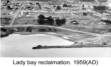
Photograph - Photograph - Lady Bay Reclamation: Aerial view looking West showing dumping of quarry overburden, 1959
Port of Portland Authority archivesFront: (no inscriptions) Back: 1959/ Lady Bay Reclamation/ Aerial view looking West showing dumping of/ Quarry overburden (black pen, upper left)port of portland archives, lady bay, reclamation, 1960s -
 Glenelg Shire Council Cultural Collection
Photograph - Photograph - Lady Bay reclamation, c. 1960
Port of Portland Authority archivesFront: (no inscriptions) Back: Lady Bay Reclamation 1959 (black pen, upper left)port of portland archives, lady bay, reclamation -
 Glenelg Shire Council Cultural Collection
Photograph - Photograph - Lady Bay Reclamation: Aerial view looking West showing dumping of quarry overburden, 1959
Port of Portland Authority archivesFront: (no inscriptions) Back: Lady Bay Reclamation 1959 (black pen, upper left)port of portland archives, lady bay, reclamation, 1960s -
 Glenelg Shire Council Cultural Collection
Photograph - Photograph - Lady Bay Reclamation: Aerial view looking West showing dumping of quarry overburden, 1959
Port of Portland Authority archivesFront: (no inscriptions) Back: Lady Bay Reclamation 1959 (black pen, upper left)port of portland archives, lady bay, reclamation -
 Glenelg Shire Council Cultural Collection
Photograph - Photograph - Lady Bay Reclamation: Aerial view looking West showing dumping of quarry overburden, 1959
Port of Portland Authority archivesFront: (no inscriptions) Back: Lady Bay Reclamation 1959 (black pen, upper left)port of portland archives, lady bay, reclamation, 1959 -
City of Moorabbin Historical Society (Operating the Box Cottage Museum)
Newsletter, City of Moorabbin Historical Society No.1 Vol. 4 January 1964, City of Moorabbin Historical Society Newsletter No. 1 Vol. 4 January 1964, 1964
This is Newsletter No 1 Vol. 4 produced in January 1964 by Mr T. A. Sheehy CMHS for members and visitors. Topic Australia Day 1803, Surveyor C.Grimes and Captain C Robbins Expedition Port Phillip Bay The Aims of the CMHS are ‘to record the history of the City, and register something of the Australian Atmosphere, which the necessary speed-up in post-world-war two (WW11) immigration has caused to be lost; to produce a magazine at regular intervals, featuring the work of pioneers and the changing Australian scene; to work constantly with a long range view towards building a hall where records and exhibits can be housed’ (1961) The Original Newsletters reflect the history and heritage of the former City of Moorabbin — derived from Mooroobin, ‘a resting place’ in the Bunurrung spoken language. In 1994, the City of Moorabbin was integrated into the Cities of Bayside, Glen Eira, Kingston and Monash. This is Newsletter No.1 Vol. 4 of the CMHS January 1964 CMHS obtained a Kingston City Council Community Grant 2016 for the digitization and preservation of these Original CMHS Newsletters commenced in 1961 1 x Foolscap paper printed on 2 sides folded for 4 pages CITY OF MOORABBIN HISTORICAL / SOCIETY / VOLUME 4 ( Number 1 ) / NEWSLETTER January 1964city of moorabbin historical society 1961, sheehy t.a., harvey l, ashley r, moorabbin city council, standard newspapers ltd., grimes charles, robbins charles, port phillip bay expedition 1803,, -
City of Moorabbin Historical Society (Operating the Box Cottage Museum)
Newsletter, City of Moorabbin Historical Society No.2 Vol. 4 February 1964, City of Moorabbin Historical Society Newsletter No. 2 Vol. 4 February 1964, 1964
This is Newsletter No 2 Vol .4 produced in February 1964 by Mr T. A. Sheehy CMHS for members and visitors Topic Australia Day1964, Port Phillip Bay 19th C , French and English Exploration 19thC The Aims of the CMHS are ‘to record the history of the City, and register something of the Australian Atmosphere, which the necessary speed-up in post-world-war two (WW11) immigration has caused to be lost; to produce a magazine at regular intervals, featuring the work of pioneers and the changing Australian scene; to work constantly with a long range view towards building a hall where records and exhibits can be housed’ (1961) The Original Newsletters reflect the history and heritage of the former City of Moorabbin — derived from Mooroobin, ‘a resting place’ in the Bunurrung spoken language. In 1994, the City of Moorabbin was integrated into the Cities of Bayside, Glen Eira, Kingston and Monash. This is Newsletter No. 2 Vol. 4 of the CMHS February 1964 CMHS obtained a Kingston City Council Community Grant 2016 for the digitization and preservation of these Original CMHS Newsletters commenced in 1961 1 x Foolscap paper printed on 2 sides folded for 4 pages CITY OF MOORABBIN HISTORICAL / SOCIETY NEWSLETTER / Vol.4 No. 2 / February 1964 -
City of Moorabbin Historical Society (Operating the Box Cottage Museum)
Newsletter, City of Moorabbin Historical Society No. 3 Vol. 4 March 1964, City of Moorabbin Historical Society Newsletter No 3 Vol. 4 March 1964, 1964
Topic Collins Expedition 1803 Port Phillip Bay; Coins; Arts&Crafts;local Theatre; The Aims of the CMHS are ‘to record the history of the City, and register something of the Australian Atmosphere, which the necessary speed-up in post-world-war two (WW11) immigration has caused to be lost; to produce a magazine at regular intervals, featuring the work of pioneers and the changing Australian scene; to work constantly with a long range view towards building a hall where records and exhibits can be housed’ (1961) The Original Newsletters reflect the history and heritage of the former City of Moorabbin — derived from Mooroobin, ‘a resting place’ in the Bunurrung spoken language. In 1994, the City of Moorabbin was integrated into the Cities of Bayside, Glen Eira, Kingston and Monash. This is Newsletter No. 3 Vol. 4 of the CMHS March 1964 CMHS obtained a Kingston City Council Community Grant 2016 for the digitization and preservation of these Original CMHS Newsletters commenced in 1961 1 x Foolscap paper printed on 2 sides folded for 4 pages CITY OF MOORABBIN HISTORICAL SOCIETY NEWSLETTER / Vol. 4 No. 3 1964 / PRESIDENT R.Ashley SECRETARY Mrs L Harvey HISTORIAN T.A.Sheehy city of moorabbin historical society 1961, sheehy t.a., newsletters, collins expedition 1803, coins, -
 Bendigo Historical Society Inc.
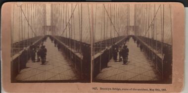
Photograph - HARRIS COLLECTION: STEREOSCOPIC VIEWS, Nineteenth Centur
Stereoscopic views. Kilburn Brothers Littleton , N H. 1. Trinity college Dublin. 2. Brooklyn Bridge, scene of the accident , May 30th 1883. 3. Spinning Room , Mechanics Mill, Fall River Mass. 4. Bay Grove Hill, Greenwood Cemetery, Brooklyn, N Y. 5.Crossing the Great Suspension Bridge, by rail. 6. Dining Hall , Grand Union Hotel, Saratoga, Largest Dining Hall in the World. 7. Phantom Leaves. 8. Full Moon. 9. Merced River, Yo-Semite , Cal. 10. I Breathe Inspiration. 11. United States Hotel Park, Saratoga.Kilburn Brothers Littleton N H.photography, viewers -
 Bendigo Historical Society Inc.
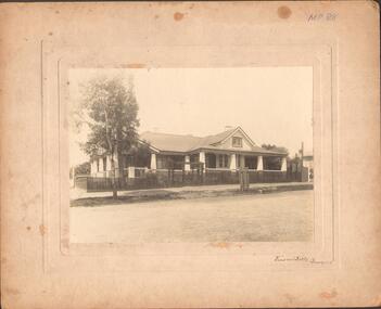
Photograph - LARGE EDWARDIAN STYLE HOUSE ON CORNER BLOCK
Black and white photograph on embossed card. Large Edwardian? Style house on corner block. Gable roof with attic in front. Bay windows under return verandah with concrete rendered supports, decorative brick work on balustrade. Picket fence with lattice on top. Pergolas over gates. Inscriptions on front - 'Vincent Kelly, Bendigo'. On back - 'Knights/front view', TC Watts & Son, Auctioneer, Estate Agents, Imperial Fire Office. Beehive Chambers, Pall Mall, Bendigo' (rectangular decorative stamp on back). 'Royal Historical Society of Victoria, Bendigo Branch (circular stamp).buildings, residential -
 Bendigo Historical Society Inc.
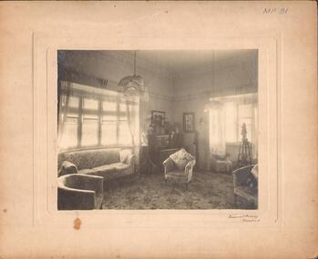
Photograph - DRAWING ROOM, c.1930
Black and white photograph. Interior view of lounge / drawing room with bay window, chairs, piano and minor statuary. Inscriptions front - 'MP91', 'Vincent Kelly, Bendigo'. On back - 'RHSV stamp', :TC Watts stamp', 'Knight's showing portion of drawing room. History: Previous Reg. No. MP91. Part of a collection of photographs used by Estate Agent TC Watt & Son, Bendigo to show potential purchasers.Vincent Kelly, Bendigoplace, drawing room, see also 2001.145.01 -
 Bendigo Historical Society Inc.
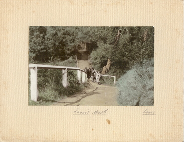
Photograph - LOVER'S WALK, COWES
coloured photo: family group ? 3 adult females in cloche hats and overcoats, two small females on scenic walk. Path through bush and trees with white post and rail fence. On front board, handwritten ' Lovers Walk, Cowes' Won by Mr. L. Batchelder ( Bendigo Photographer's family ? ) ' Gents Rope Quoits/Bay View Cowes, Feb. 1933 'A.J. Murray, Ciommercial Photographer, Photo Shop, Cosesplace -
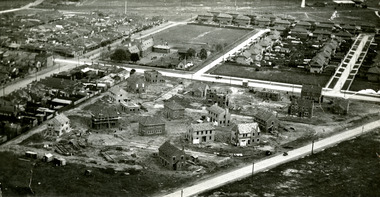 Port Melbourne Historical & Preservation Society
Photograph - Aerial view of houses during construction on Dunstan Estate, Port Melbourne, Department of Public Works, 1936
Twenty five (25) black and white or sepia photographs of the houses of the Dunstan Estate during their construction i.e. Griffin Crescent and Southward Avenue .04 - Aerial photographs (also shows Graham St School) Taken in 1936, some cars shown parked in streetsbuilt environment - domestic, domestic life, department of public works, dunstan estate, percy e everett, henry pye, albert dunstan -
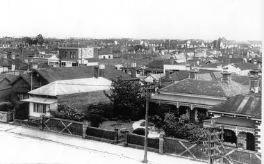 Port Melbourne Historical & Preservation Society
Photograph - 64 Evans Street, Port Melbourne, Jack GOULD, c. 1950
This was the second house built by Caleb Kennett on this site. His was the first house in Evans Street, 1868. At turn of 21st century, home of Jenny and Noel Turnbull. Copied from Gould collection.Lasercopy of photo of 64 Evans Street and surrounding area (bird's eye view), originally home of abattoir owner Caleb Kennett..built environment - domestic, caleb kennett, noel turnbull, jenny turnbull, jack gould -
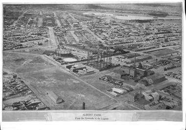 Port Melbourne Historical & Preservation Society
Photograph, E C Joshua, Albert Park from the Gasworks to the Lagoon, 1921
Rare copy of E C JOSHUA and Captain LARKIN work."Albert Park from the Gasworks to the Lagoon" Copy of aerial photography 1921 of former lagoon area taken by E C JOSHUA (photographer) and Captain H J LARKIN (pilot). "Views from an Aeroplane" black and white copy. Plus separate sheet giving brief description of photographtransport - aviation and aerodrome, sandridge lagoon, natural environment, recreation, built environment, parks and gardens, e c joshua, h j larkins, gasworks, schumaker mill furnishing works, pump house, sugar shed, joshua bros distillery