Showing 39 items matching "belmont avenue"
-
 Kew Historical Society Inc
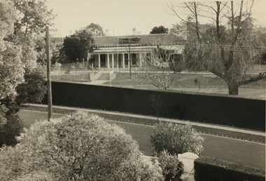
Photograph, Glendonald School for the Deaf, Marshall Avenue, 1960-1970
... Victorian mansion in Belmont Avenue, Kew, the John Cannon Hostel... Victorian mansion in Belmont Avenue, Kew, the John Cannon Hostel ...Glendonald School for Deaf Children was run by the Victorian Education Department. It provided education and some residential services for deaf children. The school was situated in Marshall Avenue, Kew and operated from 1951–91. Deaf children whose families lived too far to travel daily were housed in a grand Victorian mansion in Belmont Avenue, Kew, the John Cannon Hostel. The school and hostel also accommodated a small number of wards of the state. Source: Glendonald School for Deaf Children (1951–91); https://www.findingrecords.dhhs.vic.gov.au/collectionresultspage/GlendonaldSchoolforDeafChildren; Accessed 05/09/2018.Glendonald was a significant mansion in Kew (now demolished) built for the industrialist and manufacturer Donald Leslie in 1886. The school was purchased by the Victorian Department of Education on 29 November 1950 for the sum of 16,500 pounds.Photograph of the front garden of Glendonald taken from Marshall Avenue."The old school for the deaf at 17 Marshall Ave for children from the age of six years to ten years old, then they would go to 25 Marshall Ave to finish their schooling leaving age 16 years old."glendonald - marshall avenue - kew (vic), education - deaf children - victoria -
 Essendon Football Club
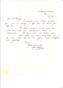
Letter, 16/10/1951
... corner is 13 Belmont Avenue, Kew. Envelope (VEF 2230.2.2... and address in top right corner is 13 Belmont Avenue, Kew. Envelope ...Essendon champion, John Coleman, was sensationally suspended before the 1951 VFL Grand Final. Many believe this cost Essendon the premiership.The letter is significant because it is one of the few hand-written letters by John Coleman held by the Hall of FameSheet of cream writing paper with pale blue lines and buff envelope; handwritten letter (VEF 2230.2.1) in dark blue ink from John Coleman to Mrs Geary thanking her for her kind words over his suspension against Carlton and subsequent missing of the Grand Final. Letter is dated 16/10/51 and address in top right corner is 13 Belmont Avenue, Kew. Envelope (VEF 2230.2.2) is addressed to Mrs D. Geary / 463 Dryburgh Street / North Melbourne and has a blue Australian 3 ╜ pence stamp in top right corner. essendon football club; john coleman; victorian football league; grand finals -
 Kew Historical Society Inc
Plan, Melbourne & Metropolitan Board of Works : Borough of Kew : Detail Plan No.1591, 1905
... Lane (now Ermington Place), and Belmont Avenue contained some... Lane (now Ermington Place), and Belmont Avenue contained some ...The Melbourne and Metropolitan Board of Works (MMBW) plans were produced from the 1890s to the 1950s. They were crucial to the design and development of Melbourne's sewerage and drainage system. The plans, at a scale of 40 feet to 1 inch (1:480), provide a detailed historical record of Melbourne streetscapes and environmental features. Each plan covers one or two street blocks (roughly six streets), showing details of buildings, including garden layouts and ownership boundaries, and features such as laneways, drains, bridges, parks, municipal boundaries and other prominent landmarks as they existed at the time each plan was produced. (Source: State Library of Victoria)This plan forms part of a large group of MMBW plans and maps that was donated to the Society by the Mr Poulter, City Engineer of the City of Kew in 1989. Within this collection, thirty-five hand-coloured plans, backed with linen, are of statewide significance as they include annotations that provide details of construction materials used in buildings in the first decade of the 20th century as well as additional information about land ownership and usage. The copies in the Public Record Office Victoria and the State Library of Victoria are monochrome versions which do not denote building materials so that the maps in this collection are invaluable and unique tools for researchers and heritage consultants. A number of the plans are not held in the collection of the State Library of Victoria so they have the additional attribute of rarity.Original survey plan, issued by the MMBW to a contractor with responsibility for constructing sewers in the area identified on the plan within the Borough of Kew. The plan was at some stage hand-coloured, possibly by the contractor, but more likely by officers working in the Engineering Department of the Borough and later Town, then City of Kew. The hand-coloured sections of buildings on the plan were used to denote masonry or brick constructions (pink), weatherboard constructions (yellow), and public buildings (grey). That area of Kew bordered by Cotham Road, Park Hill Road, Ermington Lane (now Ermington Place), and Belmont Avenue contained some of the significant homes owned by Kew pioneers. Chief among these was ‘Park Hill’ on an enormous lot facing Park Hill Road. The Jubilee History of 1910 noted, six years after this plan was drawn, that: ‘Park Hill Road, forming the southern boundary of the cemetery, takes its name from Park Hill, the residence of Mr. Thomas Judd, who has resided there since December, 1852.’ Other named houses on the plan include ‘Ferndale’ facing Cotham Road; ‘Ermington’ adjacent to Judd’s Park Hill, facing Park Hill Road; and ‘Gilden’ and ‘Mont Belmont’ facing Belmont Avenue. Mont Belmont was designed by the architectural firm of Reed, Henderson and Smart for William George Lilley in 1887 and was completed in 1888. Lilley was Mayor of Kew in 1887-88, a Justice of the Peace and a member of the first Board of Guardians of Kew’s St. Hilary’s Church of England.melbourne and metropolitan board of works, detail plans, survey plans - borough of kew, mmbw 1591, cartography -
 Kew Historical Society Inc
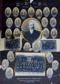
Photograph, Kew Bowling Club, Runners up for Pennant and for Championship Rink; Office Bearers of Club and Members of Pennant and Champion Rink Teams, 1908-9
... & lithographers] - SIMONTON Alan Thompson, dairyman, Belmont Avenue, Kew... & lithographers] - SIMONTON Alan Thompson, dairyman, Belmont Avenue, Kew ...The Kew Bowling Club was formed in 1880 and merged with Auburn Heights Recreation Club in 1998. In addition to the unnamed members of the teams, the following individuals are profiled on the item. The background of these men has been identified by John Torpey as follows: BRADSHAW William Henry, grocer, 6 Cotham Road, Kew & 33 Prospect Hill Road, Camberwell - CARNEGIE J Lewis, merchant, Studley Avenue, Kew [Carnegie & Sons, piano & organ importers 106 Elizabeth Street, Melbourne] - CLARKE Charles, warehouseman, 35 Queen Street, Kew - EDGAR Robert McCutcheon, 215 High Street, Kew - FINLAYSON John Marshall, solicitor, 178 Cotham Road, Kew - GREEN Charles Henry, clerk, 81 Wellington Street, Kew - GREENHILL F snr [not found] - GREENHILL Thomas jnr, traveller, High Street south, Kew - HAMBLETON Lincoln, civil servant, 32 Coleridge Street, Kew - HANDBURY John, manufacturer, 55 Walpole street, Kew - JELLIS Thomas G, baker, Princess Street, Kew - LILBURN William Hugh solicitor, Denmark Street, Kew - MANSFIELD Allan, plumber, 150 Cotham Road, Kew [S&McD] or 21 Belmont Avenue, Kew [Electoral Roll 1909] - NATHAN Simeon, warehouseman, 59 Sackville Street, Kew - NIVEN Henry N, 192 Barkers Road, Kew [FW Niven & Co 40-42 Flinders Street, Melbourne, printers & lithographers] - SIMONTON Alan Thompson, dairyman, Belmont Avenue, Kew - SINUCH WC [not known – bottom right of frame] - SWINBURNE George [see Australian Dictionary of Biography] - TREDENNICK William, civil servant 285 Tennyson Street, Kew - WENTWORTH William Dalton, painter, 5 Derrick Street, Kew - WOOLLARD Thomas, civil servant, Hildebrand Crescent, Hawthorn - WOOLLARD Walter Herbert, builder, 35 Disraeli Street, Kew [Sources: Sands & McDougall directories, Electoral Roll 1909]The photographic collage is historically important as it includes rare photographs of local identities, many of whom were significant civic actors statewide.Large photo collage created by Barroni & Co (Melb) of team, player and official portraits of members of the Kew Bowling Club. At one stage the item was in a drawer in a map cupboard, fractured into multiple pieces. The items were later assembled some years ago Graham Lindsay and framed in 2021 for exhibition by John Torpey. "Kew Bowling Club / Season 1908-9 / Runners up for pennant and for Championship Rink / Office bearers of Club and Members of Pennant and Champion Rink Teams".kew bowling club -
 Kew Historical Society Inc
Plan - Subdivision Plan, J R Mathers & McMillan, Plan of Subdivision of Part of Crown Portion 83 at Kew : LP6669, 1923-1939
... In 1888, in the section of Park Hill Road between Belmont... In 1888, in the section of Park Hill Road between Belmont Avenue ...In 1888, in the section of Park Hill Road between Belmont Avenue and Normanby Road there was only one street running between Park Hill Road and Cotham Road. This was Park Road, later to be named Adeney Avenue. Subsequent 20th century subdivisions created the ‘through roads’ of Cecil Street, Wimba Avenue, Florence Avenue, Marshall Avenue, Uvadale Road, and Barrington Avenue. This subdivision represents an attempt by auctioneers, rather than town planners to create an urban environment from larger residential allotments or in many cases farmland. Existing streets such as Parkhill and Normanby Roads provided a convenient starting point for the surveyors, but the Road named ‘Street Street’ indicates the role of the private surveyor in creating streets. Given that a number of allotments are listed as sold on the plan, the street is presumably Cecil Street. Even those lots that had been sold do not quite match the dimensions of the blocks in this parcel of land today, indicating that either further subdivisions or boundary alterations occurred.Subdivision plans are historically important documents used as evidence for the growth of suburbs in Australia. They frequently provide information about when the land was sold as well as evidence relating to surveyors and real estate and financial agents. The numerous subdivision plans in the Kew Historical Society's collection represent working documents, ranging from the initial sketches made in planning a subdivision to printed plans on which auctioneers or agents listed the prices for which individual lots were sold. In a number of cases, the reverse of a subdivision plan in the collection includes a photograph of a house that was also for sale by the agent. These photographs provide significant heritage information relating house design and decoration, fencing and household gardens.The photograph may also be aesthetically significant depending on the importance of the photographic atelier.Hand-drawn subdivision plan of 19 lots facing Parkhill Road, Normanby Road, and an unnamed street [now Cecil Street] in Kew.Estate Agent notes in ink indicate those lots which had sold.subdivision plans - kew, parkhill road - kew, cecil street - kew, normanby road - kew, cecil street -kew, parkhill road - kew, normanby road - kew, crown portion 83 - kew -
 Kew Historical Society Inc
Archive (Sub-series) - Subject File, Kew Historical Society, Gardens (Kew), 1979
... House, Cotham Road (Charleville), 7 Adeney Avenue, 20-21 Belmont... House, Cotham Road (Charleville), 7 Adeney Avenue, 20-21 Belmont ...Various partiesReference, Research, InformationSecondary Values (KHS Imposed Order)Correspondence and newspaper articles/clippings relating to historic gardens in Kew. The oldest item is a letter from the National Trust Victoria announcing their two-year garden study and seeking information on gardens in Kew. Mavis Rolley, Secretary of the Society, made handwritten notes in response, which are kept in the file. She refers to: the pear trees planted by William Oswin in c. 1845 near what is now the Burke Road Bridge (she notes that a search for the trees at the time of the construction of the Eastern Freeway was unsuccessful), a camellia planted by the Dannocks near the corner of Derby and High Street, a c.1876 pine tree in Field Place, Henty Court, an 1875 Moreton Bay fig at Tarring, Ruyton, a Moreton Bay fig at Roxeth, Trinity Grammar, an 1840s oak tree and a 120-year old olive tree at Fairholme, Barry Street, 1870 pine trees at D’Estaville, Barry Street, trees at Turinville, Barnard Grove, dating to 1846, pine trees dating from 1845-6 on the Willsmere Farm, red gums in Victoria Park, pine trees in the Cemetery dating from the 1860s, trees in the Alexandra Gardens and at Kew Primary School, palm trees at La Verna, Sackville Street dating from the 1890s, the trees and gardens at Ross House (Charleville), and the trees at Merridale, Sackville Street which date from the 1880s, a magnolia at Lalla Rookh. These dates are probably highly contestable. Other handwritten notes from 1979 about significant gardens included: 5 Molesworth Street, Red Bluff - Redmond Street (garden now destroyed), Campion House, Studley Park Road, Raheen, Studley Park Road, Ross House, Cotham Road (Charleville), 7 Adeney Avenue, 20-21 Belmont Avenue, 52 Mary Street, an Edna Walling garden on the corner of Argyle Road and Victor Avenue, Merridale, Sackville Street, Roseneath, and Reno, St John’s Parade.gardens - private - kew (vic), garden design - kew (vic), kew horticultural societygardens - private - kew (vic), garden design - kew (vic), kew horticultural society -
 Whitehorse Historical Society Inc.
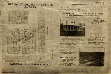
Document, Belmont Orchard Estate, 1924
Brochure for auction of Belmont Orchard Estate, BlackburnBrochure for auction of Belmont Orchard Estate, Blackburn, (now Nunawading) 66 sites, 2 February 1924. Agents: Coghill & Haughton, Frank Fisher.Brochure for auction of Belmont Orchard Estate, Blackburnauctions, belmont orchard estate, patterson street, nunawading, central road, joyce street, lilian street, west avenue -
Surrey Hills Historical Society Collection
Map, Contour map of Surrey Hills showing potential sites for the Telecom Tower
The PMG / Telecom / Telstra tower was built in 1961-1963 as a relay station to support television and radio links between city and regional broadcasting stations. The tower itself was 45 m in height with a 2 storey building for equipment and staff surrounded by garden. From the beginning it was opposed by local residents. The location is said to be the second highest site in Melbourne, sometimes described as Delaney's Hill.Two A3 photocopied sheets of a map showing part of Surrey Hills, roughly between Windsor Crescent and Belmont Street (north / south) and Standard Avenue and Balmoral Crescent (east / west). The map shows contour lines and house sites, 16 of which are numbered. One sheet has been inscribed in top RH corner with notes regarding the significance of the numbers."Contour map of potential sites / for the telecommunications tower which / was eventually sited at 2. / Jock Campbell OBE was our neighbour / at 4 Theodore St when we moved into / the area in 1984. He was responsible in his / job at the PMG in deciding on the /site of the tower - Note site 5 was / behind his (& our) house. / Jack ended his career as Deputy Director / of the PMG. He sat on international committees / after WW2 to decide the split of the electronic / spectrum for radio, TV etc. / His group developed a "mobile phone" using / fixed towers but the phone was a truck full of gear."contour map, telecom tower, maps, jock campbell, john duncan campbell -
Surrey Hills Historical Society Collection
Folder of real estate advertisements, Folders of real estate advertisements (Streets beginning with B), Various
... road barton street beatrice avenue beatty street bedford avenue ...A4 folders with individual pockets for each property in streets beginning with B located in Surrey Hills and Mont Albert. Folders are ordered by street name and then chronologically by property number. Each property has its own pocket. This may include multiple real estate advertisements collected from sales over time. It may also include copies of any research undertaken by Alan Holt and / or members of the SHNCHC team. These are augmented by cards in the Alan Holt index file and by his property registers of Surrey Hills and Mont Albert.balmoral crescent, banool road, barloa road, barton street, beatrice avenue, beatty street, bedford avenue, beech street, belmont street, benson street, bentley street, benwerrin street, black street, blackburn street, blenheim street, boisdale street, bona vista avenue, bonner street, boronia street, bristol street, broughton road, bundoran parade