Showing 514 items
matching black forest
-
 The Beechworth Burke Museum
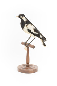
Animal specimen - Magpie-Lark, Trustees of the Australian Museum, 1860-1880
The Magpie-Lark, also commonly known as a Mudlark, is a carnivorous bird found in many regions of Australia, Indonesia, Timor, and Southern New Guinea. They are a non-migratory species and are extremely adaptable to a variety of environments. These environments include dry forest, savannah, grassland, and even urban areas. Magpie-Larks are typically monogamous and are often found in pairs. They are black and white, with a white underbelly, long legs, and a long, thin beak. The females of this species have a white throat, while the males have a white eyebrow and a black throat. While juveniles have dark eyes, mature adults have light irises. This information helps identify this specimen as an adult male. This specimen is part of a collection of almost 200 animal specimens that were originally acquired as skins from various institutions across Australia, including the Australian Museum in Sydney and the National Museum of Victoria (known as Museums Victoria since 1983), as well as individuals such as amateur anthropologist Reynell Eveleigh Johns between 1860-1880. These skins were then mounted by members of the Burke Museum Committee and put on display in the formal space of the Museum’s original exhibition hall where they continue to be on display. This display of taxidermy mounts initially served to instruct visitors to the Burke Museum of the natural world around them, today it serves as an insight into the collecting habits of the 19th century.This specimen is part of a significant and rare taxidermy mount collection in the Burke Museum. This collection is scientifically and culturally important for reminding us of how science continues to shape our understanding of the modern world. They demonstrate a capacity to hold evidence of how Australia’s fauna history existed in the past and are potentially important for future environmental research. This collection continues to be on display in the Museum and has become a key part to interpreting the collecting habits of the 19th century.The Magpie-Lark is a small to medium-sized bird which has distinctive black and white colouring. The bill is long and thin and is a whitish colour which differentiates it to other Magpie species. When mature, like this particular specimen, the Magpie-Lark have distinctive light irises. The glass eyes provided for this specimen are accurate in colour. This male specimen has a white 'eyebrow' marking and a black chest or bib. This Magpie-Lark stands on a wooden mount with a swing tag attached to its leg.Swing-tag: 20a. / Reed Grallina / See catalogue page 10 / taxidermy mount, taxidermy, animalia, burke museum, beechworth, australian museum, skin, reynell eveleigh johns, bird, mudlark, magpie-lark -
 The Beechworth Burke Museum
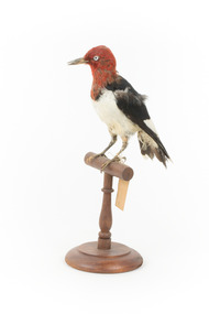
Animal specimen - Red Headed Woodpecker, Trustees of the Australian Museum, 1860-1880
Red Headed Woodpeckers can be found in Southern Canada and a large portion of the United States of America, generally migrating to the south if they originated in the northern regions. Their habitat is open forests or savannahs. They are classed as omnivores, finding food from pecking at wood or in flight. The Red Headed Woodpecker is threatened in Canada and some areas of the United States due to deforestation, lack of deadwood for nesting, competition with other birds, and a lack of food. They are an important part of the ecosystem, controlling insect populations and pollinating flora. Red Headed Woodpeckers typically have a beautiful, vibrant red neck and head, a stark white chest, black back, and black wings with white secondary remiges. They have a large chisel-like beak, suitable for foraging for their food. Their heads are rounded and they have short tails. This specimen is part of a collection of almost 200 animal specimens that were originally acquired as skins from various institutions across Australia, including the Australian Museum in Sydney and the National Museum of Victoria (known as Museums Victoria since 1983), as well as individuals such as amateur anthropologist Reynell Eveleigh Johns between 1860-1880. These skins were then mounted by members of the Burke Museum Committee and put-on display in the formal space of the Museum’s original exhibition hall where they continue to be on display. This display of taxidermy mounts initially served to instruct visitors to the Burke Museum of the natural world around them, today it serves as an insight into the collecting habits of the 19th century.This specimen is part of a significant and rare taxidermy mount collection in the Burke Museum. This collection is scientifically and culturally important for reminding us of how science continues to shape our understanding of the modern world. They demonstrate a capacity to hold evidence of how Australia’s fauna history existed in the past and are potentially important for future environmental research. This collection continues to be on display in the Museum and has become a key part to interpreting the collecting habits of the 19th century.This Red Headed Woodpecker is a small to medium-sized bird found in North America. This specimen is tricoloured: it has a red head and neck, a white chest, a black back, and black wings with white secondary remiges. It has a large chisel-like beak. This specimen has pest or humidity damage on the neck and head area. This specimen is standing on a wooden mount with a swing tag attached to it's leg.Swing-tag: 151a. Unnamed / Catalogue page, 60 /taxidermy mount, taxidermy, animalia, burke museum, beechworth, australian museum, skin, reynell eveleigh johns, bird, red headed woodpecker -
 The Beechworth Burke Museum
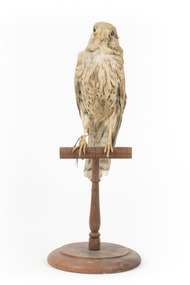
Animal specimen - Common Buzzard, Trustees of the Australian Museum, 1860-1880
The Common Buzzard is part of the buteo genus (Latin for buzzard or hawk) which indicates it is part of the raptor group whose features include a medium to large build, a strong body and larger wings. The family includes birds of prey such as hawks and buzzards. Like their name suggests, Common Buzzards are very ‘common’ in the UK but can also be found in other parts of Europe, Africa and Asia. The birds’ habitat consists of woodland, shrubland, forest, wetlands and countryside, and they can live in cold, tropical and temperate climate zones. Similar to other raptor species, Common Buzzards make their nests in tree branches or tree forks. With finely tuned hearing, they are able to detect small marsupials, and their diet consists of small amphibians, birds and mammals. Normally solitary, these raptors can occasionally be seen with others. Common Buzzards are classified as of ‘Least Concern’ on the IUCN Red List. While there is some noticeable fading of this particular taxidermy specimen’s plumage, it is relatively well presented. The completely black eyes and string through the nose of the specimen seem to be taxidermy/curatorial choices, as this is not something that is normally found on living versions today, and the eyes of Common Buzzards are normally golden eyes with black pupils. It is interesting to note, when considering the selected artificial eyes, that the original swing tag labeled this specimen as Saleo tinnunculus Lina, a form of kestrel (known to have complete black eyes), which perhaps explains this taxidermist choice. As a Common Buzzard, this particular specimen could have had its frame and breast area bulked out a little more, as birds within the buteo genus are generally recognised to be of medium to large build. Overall however, this is a fairly reasonable and accurate representation of the species. This specimen is part of a collection of almost 200 animal specimens that were originally acquired as skins from various institutions across Australia, including the Australian Museum in Sydney and the National Museum of Victoria (known as Museums Victoria since 1983), as well as individuals such as amateur anthropologist Reynell Eveleigh Johns between 1860-1880. These skins were then mounted by members of the Burke Museum Committee and put-on display in the formal space of the Museum’s original exhibition hall where they continue to be on display. This display of taxidermy mounts initially served to instruct visitors to the Burke Museum of the natural world around them, today it serves as an insight into the collecting habits of the 19th century.This specimen is part of a significant and rare taxidermy mount collection in the Burke Museum. This collection is scientifically and culturally important for reminding us of how science continues to shape our understanding of the modern world. They demonstrate a capacity to hold evidence of how Australia’s fauna history existed in the past and are potentially important for future environmental research. This collection continues to be on display in the Museum and has become a key part to interpreting the collecting habits of the 19th century.With similar colourings and features to a range of raptor species, the Common Buzzard can often be mistaken for other varieties of buteo and raptor. The bird’s plumage generally varies by location, but normally includes a variety of shades of brown, commonly with darker brown on its back and lighter coloured feathers on its breast, underbelly areas and face. These birds normally have fine bands on their tail and darker tipped wings. Common Buzzards have smaller heads with a band of yellow around the base of their small curved beaks and golden yellow eyes. This particular specimen’s feathers have faded and he stands upon a wooden perch with an identifying tag hanging from its right leg.Swing Tag: Swing tag obverse seems to read: ‘…io [? First few symbols aren’t clear]/ Saleo /tinnunculus/ Lina [there is also another illegible symbol on the tag in the centre on the second line] Swing tag reverse: illegible sections of text and the beginning of a number ‘403…[?]. Metal tag: 1032[?]taxidermy mount, taxidermy, animalia, burke museum, beechworth, australian museum, skin, reynell eveleigh johns, bird, common buzzard, buteo, hawks, raptors, birds of prey, buzzards -
 The Beechworth Burke Museum
Audio - Oral History, Jennifer Williams, Mr Ken Howe, 23rd September 2000
Ken Howe was born on the 9th February 1941 in Beechworth. His parents came from Everton. His mothers parents were from Northern Island and his fathers parents from Everton. They were farmers and did not come to Beechworth for gold. Ken left school when he was 13 and a half and worked at the Zwar brothers Tannery for four years. He then went on to work at with the Forest Commission. Ken discusses his job's, family, the arrival of Baltic immigrants after world war 2, The impact of the story of Kelly's in his life and just life in general at Beechworth. This oral history recording was part of a project conducted by Jennifer Williams in the year 2000 to capture the everyday life and struggles in Beechworth during the twentieth century. This project involved recording seventy oral histories on cassette tapes of local Beechworth residents which were then published in a book titled: Listen to what they say: voices of twentieth century Beechworth. These cassette tapes were digitised in July 2021 with funds made available by the Friends of the Burke.Ken Howe's story offers an insight into life in Beechworth from the 1940's onwards, he details the various jobs that occurred in the Zwar brothers tannery factory, the tasks that occurred for the forest commission. He also provides insight into the role the Kelly story played in their lives and the significant places were incidents occurred. His story also offers a look into everyday Beechworth life and how the baltic immigrants after World War 2 integrated into the Australian lifestyle by working at the Zwar brothers tannery. This oral history account is socially and historically significant as it is a part of a broader collection of interviews conducted by Jennifer Williams which were published in the book 'Listen to what they say: voices of twentieth-century Beechworth.' While the township of Beechworth is known for its history as a gold rush town, these accounts provide a unique insight into the day-to-day life of the town's residents during the 20th century, many of which will have now been lost if they had not been preserved.This is a digital copy of a recording that was originally captured on a cassette tape. The cassette tape is black with a horizontal white strip and is currently stored in a clear flat plastic rectangular container. It holds up 40 minutes of recordings on each side.Mr Ken Howe /listen to what they say, beechworth, oral history, burke museum, ken howe, howe, everton, northern island, farmers, zwar brothers tannery, glue, forest commission, family -
The Beechworth Burke Museum
Audio - Oral History, Jennifer Williams, Mrs Vanessa McDonald, 9 November 2000
Mrs. Vanessa McDonald was born in Beechworth in 1917. Christened, Agnes Bertha Collins, Vanessa changed her name in 1960. Mrs. McDonald's family's connection with gold mining in the district reach back to the first of Beechworth's gold rushes, when her great grandfather, a Dutchman who adopted the name Charles Collins, arrived in 1851-1852. Mrs. McDonald spent her childhood in the isolated hamlet of Stanley, in the area known as 'Little Scotland', where she recalls helping her mother to raise younger siblings, picking apples and walnuts on the family farm, and roaming the hills for wildflowers. As a young woman Mrs. McDonald attended religious and social gatherings in the local community. In 1940 she went to Melbourne to work as a mothercraft nurse during the Second World War. She met her husband at a Beechworth football match and was married at the Stanley Methodist Church in 1941. The gold diggings known as the 'Nine Mile' became the hamlet of Stanley, after the British Prime Minister, Lord Stanley, in 1858. By the late 1850s, Stanley boasted schools, an athenaeum, a church, a weekly newspaper and several hotels and other civic infrastructure to cater for a growing population. The area attracted large numbers of Chinese miners, whose presence was frequently resisted. Like other early Victorian mining settlements, Stanley was a hotbed of political and racial tensions during the gold rush. One side of the Nine Mile Creek was known as 'Little Scotland’, the other, 'Little Ireland'. A number of Christian denominations built congregations and churches in Stanley, including the Church of England, Methodist Church, the Catholic Church, and Presbyterian Church. Stanley became part of the United Shire of Beechworth in 1871. By 1880 timber was being cut and two sawmills were established by 1887. River-dredged gold mining consumed vast amounts of timber from the forests in the area, and in 1931 the first of several softwood plantations began. This oral history recording was part of a project conducted by Jennifer Williams in the year 2000 to capture the everyday life and struggles in Beechworth during the twentieth century. This project involved recording seventy oral histories on cassette tapes of local Beechworth residents which were then published in a book titled: 'Listen to what they say: voices of twentieth century Beechworth'. These cassette tapes were digitised in July 2021 with funds made available by the Friends of the Burke.Following the decline in the mining and associated industries during the early-mid-twentieth century, the Beechworth district experienced a period of general economic decline. On the east side of the Dingle Range, Mrs. McDonald's father, William Henry Collins, felled timber and the family were pioneer apple orchardists. The establishment of apple orchards in Stanley reflects changes to how land was used and contributes to our understanding of the historical development of rural communities following the gold rush. Mrs. McDonald's recollections are significant for understanding family and social life in a small rural town in years leading up to the Great Depression and prior to the Second World War. This oral history recording may be compared with other oral histories and items in the Burke Museum's collection. This oral history account is socially and historically significant as it is a part of a broader collection of interviews conducted by Jennifer Williams which were published in the book 'Listen to what they say: voices of twentieth-century Beechworth.' While the township of Beechworth is known for its history as a gold rush town, these accounts provide a unique insight into the day-to-day life of the town's residents during the 20th century, many of which will have now been lost if they had not been preserved.This is a digital copy of a recording that was originally captured on a cassette tape. The cassette tape is black with a horizontal white strip and is currently stored in a clear flat plastic rectangular container. It holds up 40 minutes of recordings on each side.Mrs Vanessa McDonald /listen to what they say, beechworth, oral history, burke museum, emigration, gold rush immigration, victorian gold rush, mining families, apple orchard, forestry, forest plantation, little scotland, stanley, twentieth century history, regional australia, rural australia, farming, harvest festival, great depression, dingle range, the nine mile, australian wildflowers, high country wildflowers, mothercraft nurse, rural and regional women, social history, collins, mrs. vanessa mcdonald, building community life, shaping cultural and creative life, fruit growers, family history, changes to land use in regional victoria -
 The Beechworth Burke Museum
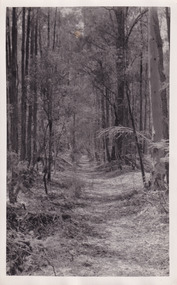
Photograph, Christmas 1941
Taken on Christmas of 1941, shown is a track to Lake Kerferd with forest on both sides. The construction on Lake Kerferd began in 1862 however it wasn't completed until 1874 due to engineering and funding issues. The lake was named after George Briscoe Kerferd (1831–1889) who was responsible for Beechworth's water scheme. George Briscoe Kerferd was born on 21 January 1831 in Liverpool, England and arrived in Melbourne April 1853. He spent his first years in Australia in Bendigo before settling down in Beechworth as a wine and spirits merchant. He married Ann Martindale on 17th December 1853 at St James Cathedral, Melbourne and between them they had three sons and five daughters. Kerferd began his political and legal career in Beechworth when he was first elected to the Municipal Council in May 1857. Later he would be elected to the Legislative Assembly for the Ovens District in November 1864, and continued to represent the area until February 1886.This photograph is historically significant as it provides insight into surrounding areas of the water reserves of Victoria. It is also linked to political identity of George Briscoe Kerferd and the Beechworth Municipal Council.Black and white rectangular photograph printed on matte photographic paper.Obverse: Reverse: 8163/ Back track to Lake Kerford/ Beechworth/ Xmas 1941lake kerferd, beechworth, water scheme, water reserve, forest track, forest pathway, reservoir, legislative assembly, hon. george briscoe kerferd, catchments, beechworth water reserve, beechworth catchments, municipal council, st. james cathedral, lakes, reserve, water supply, political projects -
 Orbost & District Historical Society
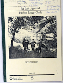
book / document, Far East Gippsland Tourism Strategy Oct 1987, October 1987
The project team for this document comprised E. Beacham, T. Claridge, B. Ebbs, C. Wilso. and J. Cristofaro.This booklet is a useful refernce tool.A document of 86 pp, titled Far East Gippsland Tourism Strategy Study Interim Report October 1987. it has a cream cover and black binding with a b/w photograph of four people in a bushland setting. It contains fold-out maps.tourism-east-gippsland -
 Orbost & District Historical Society
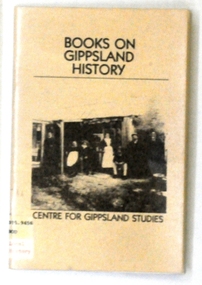
Book, Gippsland Institute of Advanced Education, Books on Gippsland History, 1985
This is a useful reference tool.A soft covered 31 pp book covered with clear plastic. The cover is beige with black print In the centre is a b/w print of the Firman family of Scrubby Forest (Yinnar). It is an annotated list of books on Gippsland history and related areas, selected for use in schools.book-books-on-gippsland-history -
 Orbost & District Historical Society
map/poster, Victorian Government Printer, 22.4.1926
The Department of Crown Lands and Survey was originally established in 1857 as part of the Board of Land and Works. In 1964 it ceased to be controlled by the Board. The Department functioned for almost twenty more years before being combined with other Ministries to form the Department of Conservation, Forests and Land. It was responsible for the management of the State's Crown land and pastoral estates. This map was used by Don Mehlert after 1928. The VERMIN AND NOXIOUS WEEDS ACT 1928 was an Act to consolidate the Law relating relating to Vermin and Noxious Weeds. E. J. E. G. Pemberton who published this poster was Superintendent of Field Staff, Dept. of Lands and Survey. This map and posters are significant records of early settlement history in Murrangower, between Cabbage Tree and Orbost,A paper map of Murrangower showing settlement subdivisions. This is glued onto the back of four overlapping cloth poster of "Notices of Vermin Destruction". All print is black."DON MEHLERT" in black pen. Pike's block shaded in blue. School site marked in blue pencil. on poster "MURRANGOWAR" along side.map-murrangower poster-vermin-and-noxious-weeds murrangower-settlement -
 Orbost & District Historical Society
black and white photograph, 1939
Buldah School was No. 4555. Mrs L. Petterson made application for a school at Buldah during 1936. It was opened on 8th of August 1937 by Herbert H. Eynstone acting as Head Teacher. He held this position for only about two weeks. The school closed during 1941. The Petterson brothers were early settlers in Cann River - late 19th century. This is a pictorial record of a school route in the first half of the 20th century. The Buldah School no longer exists.A black / white photograph of a bush track in a forest. There is water running across the track.on back - Don. by Mrs D. Petterson, only track to Buldah School in winter 1939...."buldah-east-gippsland -
 Orbost & District Historical Society
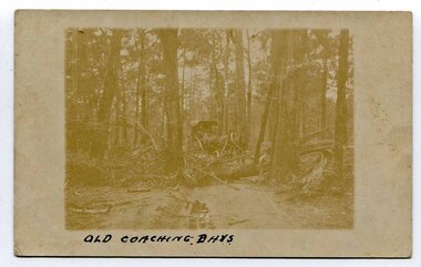
black and white photograph, late 19th - early 20th century
This is a pictorial record of horse-drawn transport in East Gippsland in the late 19th - early 20th century. It depicts the difficulties of transport in the under-developed forests of East Gippsland.A very faded photograph of horses and coach making their way through a bush track obstructed by fallen trees.on front - " Old Coaching Days" on back - ' A. Coulton"transport-horse-drawn -
 Orbost & District Historical Society
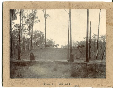
black and white photograph, Wood, 1901
This photograph appears to have been taken during the construction of the rifle range just north of the Orbost township. "The photo shows the range stop butt being formed by the scoops being pulled by the horses. It appears that the rear of the mound there is a wall of logs lining it, most likely to help with being eroded or washed away. They haven’t yet formed the mantlet and target machines." ( Info, from Victorian Rifle Association) The Orbost Rifle Club existed in the early 20th century. (There are records from 1900). It folded in the late 1970's.Target shooting is one of the oldest organised sports in Australia. Records date back to the British Marines at Sydney Cove in 1788. The Victorian Rifle Association (VRA) was formed in 1860. After Federation in 1901, rifle clubs came under army control, but in 1921 they were reconstituted as a civilian organisation, which they have remained ever since. After World War I a system of national training was embodied in the Defence Act and the rifle clubs reverted to their purely sporting role. A black / white photograph of four men and four horses standing an a soil bank with another man, a lady and a small girl at the base of the hill. It is in a clearing in forest. It appears to have a row of targets set at the edge of the bank. The photograph is mounted on a very mouldy cream coloured buff card.on front - "Wood" ; "Rifle Range - 1901" ; "Orbost 1901"sport-shooting orbost-rifle-range -
 Orbost & District Historical Society
black and white photograph, 1920 - 1930
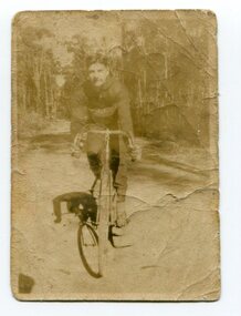
... in a forest. black and white photograph ...By 1905 there was an Orbost Bicycle Club. E. Donchi was a member and was a successful competitor around 1927. It is likely that the Orbost Cycling Club disbanded during WWI, and evidence from the Snowy River Mail is that it reformed again in 1945. There is no doubt that bikes were a dominant form of personal transport until the 1960s when cars ownership became more common, although children still rode to school. As far as theOrbost Cycling Club was concerned, the golden years were from 1945 to 1950. (information Newsletter August 2018 - Geoff & Lee Stevenson)This item is associated with a popular recreational activity in early Orbost. The period between the First World War and the 1950s was the heyday of cycling. After 1900 the efficient mass production of standardized safe bicycles, as well as the wider availability of second-hand bicycles, caused rapidly dropping prices and it was therefore easier for people to purchase a bicycle not only for utilitarian use but for racing. A small black / white photograph of a young man on a racing bike. It is on an unsealed road in a forest. on back - "E. Donchi, Cyclist, Orbost"donchi cycling-orbost recreation -
 Orbost & District Historical Society
black and white photograph, first half 20th century
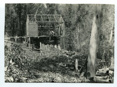
There is no information with this item.A black / white photograph of four men - three standing and one sitting in a half built wooden hut. It is overlooking a forested gully and a mine shaft.mining -
 Orbost & District Historical Society
book, The White Woman, 1994
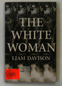
The white woman of Gippsland, or the captive woman of Gippsland, was supposedly a European woman rumoured to have been held against her will by Aboriginal people in the Gippsland region of Australia in the 1840s. Liam Patrick Davison (29 July 1957 – 17 July 2014) was an Australian novelist and reviewer. He was born in Melbourne, where, until 2007, he taught creative writing at the Chisholm Institute in Frankston. Davison and his wife Frankie, a teacher at Toorak College, were both killed on 17 July 2014 aboard Malaysia Airlines Flight 17 This, his third novel, was shortlisted for both The Age Book of the Year and the Victorian Premier’s Awards.This is a useful research tool on the history of indigenous and settler relationships in early Gippsland.A book titled "The White Woman" by Liam Davison. It is the story of the search for the lost white woman in Gippsland, Victoria, 1846. The cover has a black and white picture of forest with the title in white print.Bottom left corner - orange sticker Orbost Secondary Collegedavison-liam aboriginal-history -
 Orbost & District Historical Society
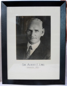
framed photo, APFA- Davisigns (PG & ME Davis)
This photo was inherited with the building when the museum was established. Lind was born in 1878 in East Charlton, Victoria, the son of Oliver Nicholas Lind, a farmer from Denmark, and his Welsh wife Mary Ann Clay. In 1882, drought forced the family to move to East Gippsland where Lind was educated at Lucknow, and then to Bairnsdale in 1884 where he attended Bairnsdale state school. In October 1920, he was elected to the Victorian Legislative Assembly for the seat of Gippsland East for the Victorian Farmers' Union. Lind was made Minister of Forests, President of the Board of Land and Works and Commissioner of Crown Lands and Survey in Albert Dunstan's cabinet. He was knighted in 1951. In 1926 two national parks east of Orbost were named the Albert and the Lind national parks after him.A framed photo of Sir Albert Eli Lind. It is a black and white head and shoulders photo in a black wooden frame.Sir Albert E. Lind Knighted !951photograph politician lind-albert government -
 The Beechworth Burke Museum
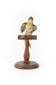
Animal specimen - Satin Flycatcher, Trustees of the Australian Museum, 1860-1880
The Satin Flycatcher is a small and energetic bird commonly found along the east coast of Australia from far northern Queensland to Tasmania. They are also located in south-eastern South Australia and New Guinea. These birds prefer to reside in tall forests and are fond of wetter habitats like forested gullies but not rainforests. These birds are dimorphic, meaning male and females have distinct forms. The male Satin Flycatcher is blue-black in colouring while the female are brown-grey with a distinct orange band on the chin, neck and breast. This specimen is part of a collection of almost 200 animal specimens that were originally acquired as skins from various institutions across Australia, including the Australian Museum in Sydney and the National Museum of Victoria (known as Museums Victoria since 1983), as well as individuals such as amateur anthropologist Reynell Eveleigh Johns between 1860-1880. These skins were then mounted by members of the Burke Museum Committee and put-on display in the formal space of the Museum’s original exhibition hall where they continue to be on display. This display of taxidermy mounts initially served to instruct visitors to the Burke Museum of the natural world around them, today it serves as an insight into the collecting habits of the 19th century.This specimen is part of a significant and rare taxidermy mount collection in the Burke Museum. This collection is scientifically and culturally important for reminding us of how science continues to shape our understanding of the modern world. They demonstrate a capacity to hold evidence of how Australia’s fauna history existed in the past and are potentially important for future environmental research. This collection continues to be on display in the Museum and has become a key part to interpreting the collecting habits of the 19th century.This female Satin Flycatcher is stylised on a wooden platform with a paper tag attached to its leg. This specimen has small glass eyes, wings positioned to its sides and a long straight tail. The colouring on this bird is a brown-grey and cream colour. It has patch of orange feathers on the neck and chin which identify the gender of this specimen. The male has glossy blue-black colouring and lack the orange plumage.33A. / Shining Flycatcher - See Catalogue, Page 13. / 50 /taxidermy mount, taxidermy, animalia, burke museum, beechworth, australian museum, skin, reynell eveleigh johns, bird, australian birds, satin flycatcher, small bird, flycatcher -
 The Beechworth Burke Museum
Photograph, c1940s
... Forest / Formed 1906 Black and white rectangular photograph ...The Bowmans Forest Fire Brigade was formed in 1906. It is one of the oldest continuous existing fire brigades in Victoria. It has an original “Fire Cart” made that year which is still in working order.Black and white rectangular photograph printed on matte photographic paperPictured: Bowmans Forest / Formed 1906emergency services, fire brigade, bowmans firest, 1906, burke museum, firemen, fire, country -
 Ballan Shire Historical Society
Map - Map. Shire of Ballan, Shire of Ballan
This is a fairly comprehensive map of the former Shire of Ballan which is now amalgamated into the Shire of Moorabool.A black and white map of the Shire of Ballan showing major roads, rivers, towns, settlements, State parks and forests and land subdivisions. It appears to be a copy of the original as no dates or maker or printer appear on the map. There is a scale of 2 miles to 1 inch.gordon, ballan, bungal, kerrit bareet, borhoneyghurk, bungeeltap, ballark, yaloak, gorong, beremboke, wallace, ingliston, hunterston, millbrook, bradshaw, myrniong, blackwood, moorarbool, greendale, bayup, trentham, bullarto, korweinguboora, glenlyon, bolwarra -
 Phillip Island and District Historical Society Inc.
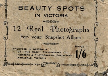
Postcard, Beauty spots in Victoria
Tourist photographs of Phillip IslandHistoricalSmall black and white photos of scenes of Phillip Island including the jetty, beach, Nobbies and ferries. Enclosed in a beige paper envelope.Beauty spots in Victoria. 12 Real Photographs for your Snapshot Album. Produced in Australia by The Rose Stereograph Co. Price 1/6 1. The Pier, Cowes, 2. Front beach, Cowes, 3. Alvina & Genista at pier, $. Koala in tree, 5. beach near Nobbies, 6. The Nobbies, 7. The Pinnacles, 8. Looking out at Forest caves, 9. Lovers Walk - Cowes, 10. Forest Cave, 11. The road to back beach, 12. The beach & pier, Cowes.the nobbies, ferries, cowes jetty, forrest caves, phillip island, black & white postcard copy, photographs -
 Orbost & District Historical Society
black and white photograph, early 20th century
The McLeods, were the original holders of the Orbost station. Sir William Clarke bought the station from McLeod Bros. Sir William was a very fine man and noted for his philanthropic actions. He finally cut up and sold the Orbost station and presented 10 acres of land to the people of Orbost for a show and recreation ground. Sir William Clarke had taken over the Orbost run from the McLeods in 1870. (more info. July 2006 Newsletter) When Sir William died the property was owned by his son, Rupert who offered the land for sale at 4 pounds per acre. No sale resulted and the property was leased for a few years until in 1898 it was subdivided and sold to many of Orbost's first families. (info. from In Times Gone By- Deborah Hall) This house was located on the western side of Forest Road. Orbost.This is a pictorial record of one of the first residences in Orbost.A black/ white photograph of a large wooden house. It has a verandah at the front and sides. There are three children two girls and a boy - standing on the verandah to the left of the door. The house is surrounded by gardens.on front - Orbost Home Stationorbost-station clarke-william clarke-rupert -
 Orbost & District Historical Society
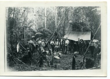
black and white photograph, 1897
This photograph shows a group of surveyors setting up at Treasury Camp - April 18 1897. Treasury camp was possibly in the Murrungowar area in East Gippsland.This is a pictorial record of a late 19th century bush camp set up by surveyors involved in determining land settlement in East Gippsland.A faded black / white photograph on a black buff card of a group of men and several pack horses standing around a campfire. The camp is in a clearing in dense forest and tents are set up with some bark coverings. There is a copy with the original.surveyors-camp-east-gippsland -
 Orbost & District Historical Society
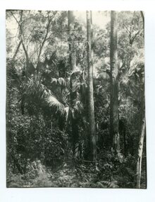
black and white photograph, first half 20th century
Livistona australis - the Cabbage Tree Palm, is a fan palm that grows naturally in the lowland forest and swamps of southern Queensland and along the east coast of Australia and it occurs further south than any other Australian palm species. It is the only palm that is found naturally in Victoria. The early settlers supplemented their meagre rations with the hearts of the Cabbage Tree Palm.This is the southernmost stand of Cabbage Tree Palms in Australia and the only location in Victoria where these palms grow naturally. This is a pictorial record of a rare native Australian palm.A black / white photograph of small palm trees in a dense bush surrounding.cabbage-tree-palm-east-gippsland -
 Orbost & District Historical Society
black and white photographs, Warren, Mrs H, early 20th century
This photograph shows Percy De Forest and his brother, Alfred of McLeod Street, Orbost. The photographer was Warren, Helena (1871-1962) who was a self-taught photographer who became both the local press correspondent and a producer of humorous trompe l'oeil postcard images. Helena Warren was a thirty-two year old settler living on a small mixed farm with her husband, William, at Newmerella, near Orbost in Gippsland, Victoria, when she bought her first camera, an Austral Box quarter-plate. Her family says she was entirely self-taught, like many women photographers who started out with nothing but the instructions on the packets of film and chemicals. In over fifty years practice she graduated from the total novice, who opened all her first mail order plates in bright sunlight and ruined them, to a competent photographer who became both the local press correspondent and an inveterate producer of humorous trompe l’oeil postcard images. Helena Francis Warren (nee McKeown) was married to William John Warren and lived in Newmerella. She supplied the photos for the Back-To-Orbost celebration book in 1937 and also designed the Back-To-Orbost badge. She was known for her soft toy making. (by Ivy Rodwell in from Personalities and Stories of the Early Orbost District by Mary Gilbert). This photograph has significance in its association with Helen Frances Warren, a popular Orbost identity who was well known as an accomplished photographer and needleworker,Two black / white photograohs of two small children sitting in a large pumpkin on water.on front - An Orbost Pumpkinpumpkins-orbost de-forest warren-helena-photography -
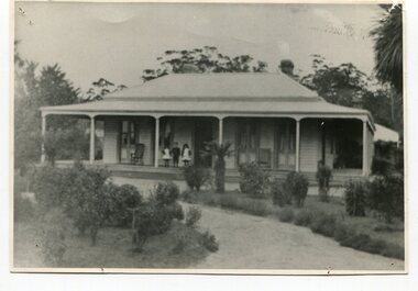
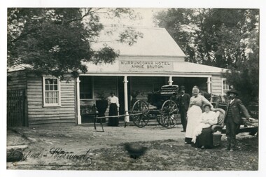 Orbost & District Historical Society
black and white photograph, early 20th century
This photograph shows Pike's buggy with Joe Pike, Mrs George Pike, Annie Bruton and Maggie Middleditch on the verandah. Annie Bruton was the wife of Jack Bruton who came to Orbost about 1891. When land was made available for selection at Murrungowar. they took up a selection and embarked in dairying, sheep-farming and pig-raising. They transformed a veritable wilderness into a productive farm by sheer hard work and liberal expenditure. By 1892 he had secured a licence for an hotel and accommodation house, store and the first post office at Murrungowar. For a time she was licensee of the Murrungowar Hotel. In December 1897 he was living at Murrungowar when he made application for a Roadside Victualler’s License for a house situated at Boulder Creek, East Gippsland, containing four rooms in course of erection, exclusive of those required for family. He was a butcher at Orbost in 1902-03 and also had a farm on the Bendoc Road. He was a member of the first Golf committee. After leasing the hotel to Jonson's he moved to Orbost and started brick-making near the Orbost water service basin on the Bendoc Road. He had the order for the bricks required for the Masonic Hall. Mr and Mrs Bruton resided at Murrungowar for 29 years. They let their property to Messrs McDONALD and sons and retired to Orbost in December 1920. Mr Bruton had not been in very good health for the last 4 or 5 years of his life, and about a fortnight prior to his death he got wet at his brick kiln, and contracted pneumonia which led to hiThis is a pictorial record of the the Murrungowar Township which was once a thriving settlement with a hotel, store, post office and school. In the 1890s pioneers were attracted to the area with the promise of a railway from Orbost. However, when the promised railway did not eventuate most of the farms were abandoned. Much of the previously cleared areas have reverted to Forest. Most of the remaining farms are now privately owned eucalypt plantations.A large black / white photograph of five people standing outside a one - storey wooden building. There is an empty buggy behind them with a horse behind it. The building has a sign above the verandah - "MURRUNGOWAR HOTEL ANNIE BRUTON".on front - "Pikes Buggy - Mrs Bruton, Mrs Geo & Mr Joe Pike" ; Herbert Sherwood photographer murrungowar-hotel bruton-annie pike-joe -
 Orbost & District Historical Society
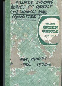
book, 1978
This collection was compiled by Peter Fagg who worked as a scientist with the Department of Sustainability and Environment (now DELWP) to study dieback in eucalypts. He specialised in the silviculture of the eucalypt forest types of South-East Australia for most of his 40-year career, which started with the Forests Commission Victoria. He was in Orbost from 1968 - 1973. The contents of the book are all related to sporting groups in Orbost at the Mechanics Hall. Peter Fagg was the Publicity Officer for the group as well as president. He was also associated with the Orbost municipal bands.This item is related to Peter Fagg, a prominent member of the Orbost community. The item is a record of sporting activities in Orbost.A hard-covered book with a green spine and a green thatched cover. It contains financial statements, newspaper cuttings, photos which have labels hand-written in pen, minutes and a brief history of the Orbost Mechanics Hall.on front cover in black marker - Affiliated Sporting Bodies of Orbost ( Mechanics Hall Committee)fagg-peter sport-orbost mechanics-hall-orbost -
 Bendigo Military Museum
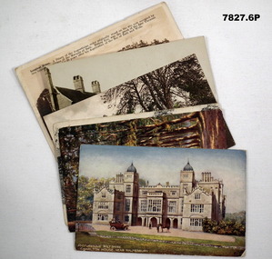
Postcard - POSTCARD, FARNHAM, U.K, Valentine's Series, cWW1
1. Florrie is a relative living in Farnham. 2. R.H. Baron married Elsie Keast in 1921. All cards relate to R.H. Baron's visits to Farnham whilst on leave to see Florrie. Part of the 'Robert H. Baron', no.3596 and Cooper Collection. See Catalogue No. 1981P for details of Baron's service.1. Coloured scene of a ruined castle and surrounding gardens. 2. Coloured scene of a garden with building and ruins in background. 3. Coloured photograph of a red brick building with battlement. 4. Coloured street scene with buildings, horse drawn transport and pedestrians. 5. Coloured photograph of the nave of a church looking towards the alter. 6. Coloured street scene with buildings and horse drawn transport. 7. Coloured view across a street to a white walled building with horse drawn transport. 8. Coloured photograph of a church, graveyard in foreground. 9. Black and white photograph of a castle surrounded by trees. 10. Black and white photograph of a forest scene with people standing on a bridge. 11. Black and white photograph of a street scene with buildings, horse drawn transport and people. 12. Black and white photograph of the tower of a church. Graveyard in the foreground. 13. Black and white photograph of a street scene with buildings, horse drawn transport and pedestrians. Castle on the hill in background. 14. Black and white photograph of a street scene with buildings, motor cars and pedestrians. 15. Black and white photograph of a street scene with buildings, motor cars, horse drawn transport and pedestrians. 16. Black and white photograph of a wooded valley. Houses on a hill in the background. 17. Black and white photograph of an avenue of trees. 18. Black and white photograph taken in a park. Three people standing on a bridge over a stream.1. The Keep, Farnham Castle. Handwritten in black ink on back: 'This is one of the pretty places around Farnham. I was all once here with Florrie. Bob' 2. In Castle grounds, Farnham. Handwritten in black ink on back: 'Dear Elsie, these are some places that visit... when I was down at Flories place. Bob xxxxxx' 3. Farnham Castle. 4. West Street, Farnham. 5. Parish Church, Farnham. 6. Castle Street, Farnham. 7. The Church House, Farnham. 8. Parish Church, Farnham. 9. Farnham Castle. 10. Red Hill Hanger, Farnham. Handwritten in black ink on back: 'Letter to R.H. Baron's sister - no date.' 11. South Street, Farnham. Handwritten in black ink on back: 'this part of the place I spent my leave at this is where Florrie is.' 12. Farnham Parish Church. Handwritten in black ink on back: 'Letter to R.H. Baron's mother - dated 24 July 1918.' 13. Castle Street, Farnham. Handwritten in black ink on back. 'I think you will know where this is as I have told you quite a lot about Farnham, it is where Florrie is. I spent my leave here. This is Castle Street and the castle is right on the top of the hill.' 14. Borough, Farnham. Handwritten in black ink on back. ' This is the place where Florrie lives. I spent my last leave their (sic), Bob.' 15. West Street, Farnham. Handwritten in pencil on back. 'Pte R.H. Baron, 57 Battalion, Australian Imperial Forces Abroad.' 16. Lower Bourne Valley, Farnham. Handwritten in black ink on back: 'Partial letter from R.H. Baron to his sweetheart.' 17. The Avenue, Farnham. Handwritten in black ink on back: 'Partial letter from R.H. Baron to his mother.' 18. Recreation Ground, Farnham. Handwritten in black ink on back: 'Letter to Doris from R.H. Baron - no date.' robert h. baron, cooper collection, postcards, farnham uk -
 Bendigo Military Museum
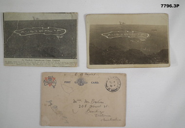
Postcard - POSTCARD - HURDCOTT, AIF CAMP, UK, R. H. Baron, 3. 3/11/1918
Cards relate to R.H. Baron's time at Hurdcott AIF Camp during 1918. Part of the "Robert H. Baron", No. 3596, and Cooper Collection. See Catalogue No. 1981P for details of Baron's service.1. Black and white newspaper clipping pasted onto a piece of cream card. Clipping features a black and white photograph of a map of Australia carved into the side of a hill. Caption in black type below photograph. 2. Black and white postcard style photograph of a map of Australia carved into the side of a hill. 3. Plain cream coloured postcard with YMCA logo and AIF insignia at the top. Handwritten address on front and handwritten letter on back.1. Handwritten in black ink on back: 'This map has been cut in the hill and is only about 10 minutes walk from here, Bob' 3. Handwritten in black ink on front: 'Miss M. Baron, 208 Forest St. Bendigo, Victoria, Australia'. Stamped in black on top R.H.C. of front: 'Postmark - AIF Camp P.O. No.4, 18,' Handwritten in black ink on back: 'Letter to R.H. Baron's sister Myrtle from Hurdcott Camp dated 3.11.18.'robert h. baron, cooper collection, postcards, hurdcott aif camp -
 Bendigo Military Museum
Postcard - POSTCARD, VARIOUS, cWW1
... Avenue, Savernake Forest. Handwritten in black ink on back... Forest. Handwritten in black ink on back: 'Letter to R.H. Baron's ...Each postcard features handwritten anecdotes and letters to various people in R.H. Baron's family. Baron was a band member. Part of the "Robert H. Baron" (No. 3596) and Cooper Collections. See Catalogue No. 1981P for details of Baron's service.1. Coloured drawing of a Stately house with motor car, people and a horse in foreground. 2. Coloured drawing of a couple walking through an avenue of trees. 3. Black and white photograph of a church with square tower. 4. Coloured photograph of a mill building and adjacent body of water. 5. Black and white photograph of a row of buildings fronting an unsealed road. 6. Sepia toned photograph of a large stately three storey house.1. Handwritten in black ink on back: 'Letter to Doris written by R.H. Baron - dated 14 July 1918'. Picturesque, Wiltshire, Charlton House, near Malmsbury. 2. Picturesque Wiltshire Avenue, Savernake Forest. Handwritten in black ink on back: 'Letter to R.H. Baron's sisters and brothers.' 3. St. Mary's Church, Motcombe, Dorset. Handwritten in black ink on back: 'We played at a service at this church last Sunday night (1/12/18), Bob xxx' 4. Worplesdan, Rickford Mill, Handwritten in black ink on back: ' Letter to Alf from R.H. Baron.' 5. Crown Inn, etc. Hartley Row. Handwritten in black ink on back. 'Anecdote signed by Bob (R.H. Baron)'. 6. Longleat House. Handwritten in black ink on back; 'We were playing at a dance at this place a few weeks ago. We had a splendid time. It is near Bath, Bob'.robert h. baron, cooper collection, postcards, ww1 -
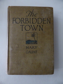 Warrnambool and District Historical Society Inc.
Book, Reflection in Jamaica, 1926
This is a novel written by Mary Gaunt (1861-1942). She was an Australian writer who published over 20 novels, many travel books, short stories and magazine articles and achieved an international reputation as an author and intrepid traveller, especially in Africa and China. From 1894 to 1900 she lived in Warrnambool (she was married to Dr H. L. Miller) and continued to write while she was resident in the town, using local places and situations in some of her writings. This is a significant book as it is an original copy of one of Mary Gaunt’s novels. As a resident of Warrnammbool for some time and as a significant Australia author she has her place in Warrnambool’s history. The inscription in the book does not have any known significance. This is a hard cover book of 314 pages. The cover is light brown with black printing on the front cover and spine and an image of a tropical island scene on the front cover. There are a signature in black ink and an inscription in pencil on the first page. The cover is very stained and the spine has a number ‘46’ on white paper glued on. ‘Charles R. Boucher’ ‘Dec. 25 1928, Charley from Ethel and Forest’. ‘46’ mary gaunt, history of warrnambool, australian literature