Showing 84 items matching "calder highway"
-
 Hume City Civic Collection
Photograph, 1993
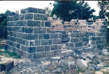
... at Gap Village on the Calder Highway and relocated in front... at Gap Village on the Calder Highway and relocated in front ...The Aitkens Gap Gaol was removed from its original site at Gap Village on the Calder Highway and relocated in front of the Sunbury Police Station in 1993.A coloured photograph of the resiting and rebuilding of the Aitken Gap Gaol outside the Police Station in Sunbury. The two end walls have been constructed as far as the windows and work has commenced on the front and back walls. Some stones are scattered around the site.peter free, aitkens gap gaol, sunbury police station, police historical association, george evans collection -
 Bendigo Historical Society Inc.
Newspaper - JENNY FOLEY COLLECTION: HEADQUARTERS
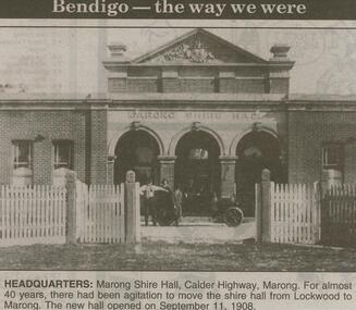
... . Headquarters: Marong Shire Hall, Calder Highway, Marong. For almost 40..., Calder Highway, Marong. For almost 40 years there had been ...Bendigo Advertiser ''The way we were'' from 2000. Headquarters: Marong Shire Hall, Calder Highway, Marong. For almost 40 years there had been agitation to move the shire hall from Lockwood to Marong. The new hall opened on September 11, 1908. The clip is in a folder.newspaper, bendigo advertiser, the way we were -
 Ballarat Tramway Museum
Slide - 35mm slide/s, Dave Macartney, Dec. 1968
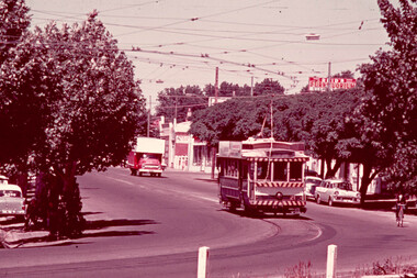
... Strip" of Bendigo No. 21 in High St (Calder Highway), near... No. 21 in High St (Calder Highway), near Short St, outbound ...White cardboard mount, 35mm slide, from the Association of Railway Enthusiast's film strip titled "Provincial Tramway Film Strip" of Bendigo No. 21 in High St (Calder Highway), near Short St, outbound to Golden Square. Photo taken after the tram has passed the photographer. Has Reid's Furntuorium sign in the background. The film strip notes (Reg. Item 2560), provided the following caption details: "The "GOLDEN SQUARE" line followed the Calder Highway toward Melbourne for a couple of miles. Here, 21 is outbound not far from Charing Cross - Dec '68 (Dave Macartney)" See image btm2583p.tif for high level scan of image. Stamped on base of slide "11792" and written in ink on top edge "21 on Golden Square"tramways, trams, are, film strip, high st, golden square, tram 21 -
 Hume City Civic Collection
Photograph
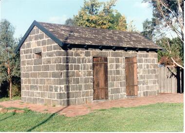
... Settlement on the Calder Highway in 1857 for the gold escorts... Settlement on the Calder Highway in 1857 for the gold escorts ...The Aitken Gap Gaol was originally constructed at the Gap Settlement on the Calder Highway in 1857 for the gold escorts. It was relocated to its present site outside the Sunbury Police Station in Macedon Street between 1989 and 1991.A coloured photograph of the relocated Aitken Gap Gaol. It has bluestone walls and a moss covered slate roof. with 2 solid stained wooden doors and blue painted wooden trims. A small cell window is on the side of the building and a paved brick area surrounds the gaol.aitken gap gaol, gap village, sunbury police station, george evans collection -
 Bendigo Historical Society Inc.
Map - DERBY : COUNTY OF BENDIGO, 1959
... , Calder Highway, Maldon to Bridgewater Road.By authority A.C..., Leichardt, Bridgewater, Loddon River, Bendigo Railway, Calder ...Map. Derby, County of Bendigo, Inglewood, Tarnagulla, Woodstock, Leichardt, Bridgewater, Loddon River, Bendigo Railway, Calder Highway, Maldon to Bridgewater Road.By authority A.C. Brooks, Government Printer, Melbourne. Drawn and reproduced at the Department of Lands and Survey, Melbourne, 1959. Price 5/-. (number 59 in map cupboard 1)A.C. Brooks, Government Printer, Melbourne.map, bendigo, derby -
Bendigo Historical Society Inc.
Map - HARCOURT, December 1951
... , Calder Highway, Northern Railway. By Authority J.J.Gourley.... Mt.Alexander Trig. Station, Barkers Creek, Faraday, Calder Highway ...Harcourt, County of Bendigo, Walmer, Castlemaine, Sutton Grange. Mt.Alexander Trig. Station, Barkers Creek, Faraday, Calder Highway, Northern Railway. By Authority J.J.Gourley, Government Printer, Melbourne,Drawn and Reproduced at the Dept. of Lands and Survey, Melbourne, Victoria. December 1951. Price 5/-per sheet. (number 35 in map cupboard 1)J.J.Gourley, Government Printer, Melbourne.map, bendigo, harcourt -
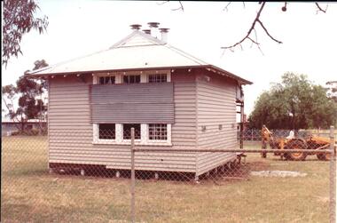 Hume City Civic Collection
Photograph, early 1990s
... the Calder Highway and was relocated to the new school building... the Calder Highway and was relocated to the new school building ...The small one roomed school is closed at the site along the Calder Highway and was relocated to the new school building in Plumpton Road at Diggers Rest. The former school building became the club rooms for the Diggers Rest Bowling Club when the new school opened in the late 1980s.A coloured photograph of the former Diggers Rest Primary School. The small one roomed weatherboard building with a corrugated iron roof has sheets of iron across the windows. The building is being prepared for relocation. A post hole digger is behind the building.diggers rest primary school, education department, diggers rest bowling club, george evans collection -
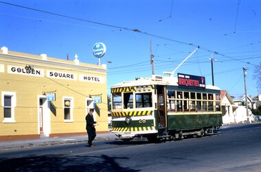 Ballarat Tramway Museum
Slide - 35mm slide/s - set of 2, Noel Simons, 21/05/1971 12:00:00 AM
... and the Calder Highway or High St. behind the tram. ... of the terminus and the Calder Highway or High St. behind the tram. Slide ...Set of 2 transparencies taken on 21/5/1971 on Kodak mounts. 1198.1 - Bendigo No. 28 at the Golden Square terminus with the Golden Square Hotel in the background. Driver walking across road to join tram. Tram has a SEC briquettes roof ad. 1198.2 - as for 1198.1 - but further back showing nature of the terminus and the Calder Highway or High St. behind the tram. Information written on in black ink and date stamped on purple ink. 1198.1 - "Birney car No. 28 at Golden Square terminus". 1198.2 - "Birney car No. 28 at Golden Square terminus" tramways, trams, bendigo, golden square, high st., tram 28 -
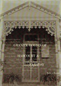 Harcourt Valley Heritage & Tourist Centre
Book, Granite Houses of Harcourt & Faraday, 2014
... with the upgrade of the Calder Highway into Freeway the Harcourt Valley... with the upgrade of the Calder Highway into Freeway the Harcourt Valley ...When the Harcourt Valley was the subject of route selection /environmental effects survey in connection with the upgrade of the Calder Highway into Freeway the Harcourt Valley Heritage Committee enumerated and researched the unique collection of granite homes to be found in the valley. The publication gives a short account of the builders and illustrates the various techniques of building in stone. Advocacy by the Harcourt Valley Heritage Committee ensured the retention, in the face of demolition threat, of a unique collection of homes, many owner-built and of vernacular architecture. A4 size book of 42 pages with full colour ilustrationsGranite Houses of Harcourt & Faraday -
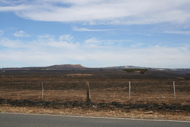 Sunbury Family History and Heritage Society Inc.
Photograph, Rosa McCall, Riddell Road, February 2014
... north of Sunbury from the Calder Highway across Riddell Road... north of Sunbury from the Calder Highway across Riddell Road ...In February 2014 severe grassfires blazed across the land north of Sunbury from the Calder Highway across Riddell Road and on to Clarkefield and beyond and caused damage to the Bendigo Railway line. This image was taken about a week later along Riddell Road and looking SW to Red Rock across the skyline.This grass fire caused much damage across a large area north of Sunbury and beyond.A coloured photograph of an open landscape that has been extensively burnt after grassfires.grass fires, riddell road, red rock, sunbury -
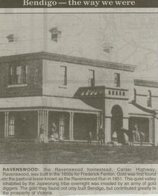 Bendigo Historical Society Inc.
Newspaper - JENNY FOLEY COLLECTION: RAVENSWOOD
... . Ravenswood: the Ravenswood homestead, Calder Highway Ravenswood..., Calder Highway Ravenswood was built in the 1850s for Frederick ...Bendigo Advertiser ''The way we were'' from 2000. Ravenswood: the Ravenswood homestead, Calder Highway Ravenswood was built in the 1850s for Frederick Fenton. Gold was first found on the pastoral lease known as the Ravenswood Run in 1851. This quiet valley inhabited by the Jajaworung tribe overnight was invaded by an army of gold diggers. The gold they found not only built Bendigo, but contributed greatly to the prosperity of Victoria. The clip is in a folder.newspaper, bendigo advertiser, the way we were -
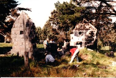 Hume City Civic Collection
Photograph, c 1993
... ) and Calder Highway (Victoria St/Mt. Alexander Road). It was part...) and Calder Highway (Victoria St/Mt. Alexander Road). It was part ...Aitkens Gap Police Lock up was originally constructed at The Gap which was south of the junction of Gap Road (Sunbury Road) and Calder Highway (Victoria St/Mt. Alexander Road). It was part of a police complex which was a changeover station for the gaol escort. The goal was relocated and rebuilt in the police station grounds in Sunbury in 1993.A coloured photograph of five men working on the removal of Aitkens Gap Gaol from its original site. Two end walls of the gaol are standing and the work is being done on the front and back of the building. Conifers and cypress trees are growing around the site.peter free, aitkens gap gaol, police historical association, sunbury police station, george evans collection -
Bendigo Historical Society Inc.
Map - HARCOURT : COUNTY OF BENDIGO, December 1951
... , Calder Highway, Northern Railway, Axe Creek. By authority J.J..., Calder Highway, Northern Railway, Axe Creek. By authority J.J ...Map. Harcourt, County of Bendigo, County of Talbot, Town of Harcourt, Walmer, Sutton Grange, Ravenswood, Victorian Water Supply Reservoir, in connection with Barkers Creek Reservoir, Barkers Creek, Calder Highway, Northern Railway, Axe Creek. By authority J.J. Gourley, Government Printer, Melbourne. Drawn and reproduced at the Department of Lands and Survey, Melbourne. December 1951. Price 5/- per sheet. (number 100 in map cupboard 1)J.J. Gourley, Government Printer, Melbourne.map, bendigo, harcourt -
Bendigo Historical Society Inc.
Map - HARCOURT : COUNTY OF BENDIGO, December 1951
... , Ravenswood. Sutton Grange, Walmer, Castlemaine, Faraday, Calder... Grange, Walmer, Castlemaine, Faraday, Calder Highway, Northern ...Map. Harcourt, County of Bendigo, County of Talbot, Ravenswood. Sutton Grange, Walmer, Castlemaine, Faraday, Calder Highway, Northern Railway, Town of Harcourt, Barkers Creek, Victorian Water Supply Res., in connection with Barkers Creek Reservoir. By authority J.J. Gourley, Government Printer, Melbourne .Drawn and reproduced at the Department of Lands and Survey, Melbourne. December 1951. Price 2/- per sheet. (number 96 in map cupboard 1)J.J. Gourley, Government Printer, Melbourne.map, bendigo, harcourt -
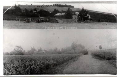 Hume City Civic Collection
Photograph, Schlossberg Vineyard, 1909
... in Sunbury, between Winilba and the Calder Highway... in Sunbury, between Winilba and the Calder Highway ...Schlossberg Vineyard was situated along Vineyard Road in Sunbury, between Winilba and the Calder Highway. It was established by Felix Frederick Bubeck, who arrived in Australia from Rotenberg (near Stuggart) in the 1860. In 1866 he acquired 60 acres of land on Bald Hill and established the vineyard. In 1880, claret produced on the property received an honourable mention when it was exhibited in Bordeaux, France,From the mid 1850s a number of vineyards were established on the hillsides overlooking Vineyard Road. The east facing outlook that captured the morning sun was ideal for growing grapevines. Other vineyards were also established in the area at the same time.A black and white copy of a postcard of two photographs mounted on the one card with the original handwritten message photocopied on the back. To my dear brother & sister with love and good wishes for a Merry Xmas & a prosperous 1909. Thanks for the paper Your loving sister Marie. You will think it a good photo You will see the trees have grown almost hiding the house. Mr. A Senling, Cheetham St. Kalgoorlie Sth. WAfelix frederick bubeck, schlossberg vineyard, bald hill, vineyards -
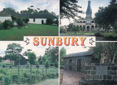 Sunbury Family History and Heritage Society Inc.
Postcard, John Munns, Sunbury, C1980s
... village on the Calder Highway.... village on the Calder Highway. The four sites featured ...The four sites featured on the postcard are: Top row L-R Emu Bottom Homestead and Rupertswood Mansion. Bottom row L-R Goonawarra Vineyard and Aitkens Gap Gaol. George Evans built Emu Bottom and William Clarke was the first owner of Rupertswood. Goonwarra was one of Sunbury's early vineyards and the gaol was relocated on the police station from its original site at The Gap village on the Calder Highway.The four sites featured are important historic places in SunburyA coloured postcard featuring four historic sites in Sunbury. The word 'SUNBURY' is printed in orange across the centre of the card. Details of the four sites, the photographer and the postcard company are on the back.emu bottom, rupertswood mansion, goonawarra winery, aitkens gap gaol, george evans, william j.t. clarke -
 Sunbury Family History and Heritage Society Inc.
Photograph, Bill Walls, Gap Gaol, c1970s
... settlement. The Gap, on the Calder Highway, preceded Sunbury's... settlement. The Gap, on the Calder Highway, preceded Sunbury's ...Bill Walls is the artist who did the original watercolour of the small building, that was originally a gaol sited at The Gap settlement. The Gap, on the Calder Highway, preceded Sunbury's settlement and the gaol was used during the 1850s gold rush era, when the precious metal was being brought to Melbourne from the gold fields. In the 1990s the building was taken down brick by brick and rebuilt in the front of the Sunbury Police Station in Macedon Street.The Gap gaol building played a significant role in the development of the local area and is of local heritage significance.A photograph of a coloured watercolour of a small bluestone building with a stone chimney and a corrugated iron roof. the gap, police station, the gap gaol, gold rushes, sunbury -
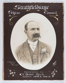 City of Greater Bendigo - Civic Collection
Photograph - Portrait of Councillor Keck, W H Robinson, c 1913
... from the Calder Highway to the Coliban and Campaspe Rivers... an area of 601 square kilometres and extended from the Calder ...The district of Strathfieldsaye was proclaimed in 1861 and named a Shire on the 17th September in 1866. It remained a shire until amalgamation in 1994 when it became part of the City of Greater Bendigo. The shire was located 8 km to the south- east of Bendigo and covered an area of 601 square kilometres and extended from the Calder Highway to the Coliban and Campaspe Rivers. The shire's administration centre was in Strathfieldsaye until 1972 when new offices were opened in Kennington.Framed black and white head and shoulder portrait of Councillor Keck with hand coloured and drawn detail. Profile slightly to right with walrus moustache. Cut oval brown mount decorated with text and flowers. Hand written title top and lower centre.Strathfieldsaye / Shire Council / W.H. Robinson / Photo / Bendigo / J.H.E Gribbs / Presented by / Cr Herbert Keck / President 1903-4. 1912-13.shire of strathfieldsaye, councillor keck, strathfieldsaye shire council, president of strathfieldsaye shire -
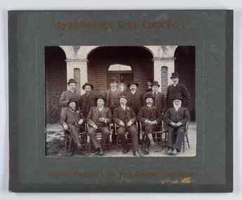 City of Greater Bendigo - Civic Collection
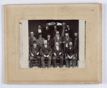
Photograph - Councillor group portrait, W H Robinson, Strathfieldsaye Shire Council, 1909
... from the Calder Highway to the Coliban and Campaspe Rivers... an area of 601 square kilometres and extended from the Calder ...The district of Strathfieldsaye was proclaimed in 1861 and named a Shire on the 17th September in 1866. It remained a shire until amalgamation in 1994 when it became part of the City of Greater Bendigo. The shire was located 8 km to the south- east of Bendigo and covered an area of 601 square kilometres and extended from the Calder Highway to the Coliban and Campaspe Rivers. The shire's administration centre was in Strathfieldsaye until 1972 when new offices were opened in Kennington.Photographic group portrait of eleven Strathfieldsaye Shire Councillors in front of the Strathfieldsaye Shire Hall. Five men are seated and six standing with one man standing further in back ground on the building's verandah. Photograph is attached directly to green mount card and framed. Gold lettering on mount.Strathfieldsaye Shire Councillors / R. B. Brennan (Sec.) W. J. Lowdes S. Doak M. Burns () N Condon B. Code (Inspector) / WH Robinson Photo Bendigo / T Somerville / W. I. Long / Fred Osborne (President) H Keck / W Dresler / With the President's (Cr. Fred Osborne) Compliments / September 23rd, 1909shire of strathfieldsaye, strathfieldsaye shire council, president of strathfieldsaye shire, strathfieldsaye shire hall -
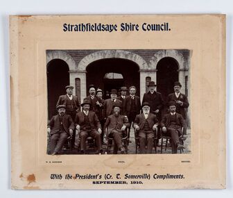 City of Greater Bendigo - Civic Collection
Photograph - Councillor group portrait, W H Robinson, Strathfieldsaye Shire Council
... from the Calder Highway to the Coliban and Campaspe Rivers... an area of 601 square kilometres and extended from the Calder ...The district of Strathfieldsaye was proclaimed in 1861 and named a Shire on the 17th September in 1866. It remained a shire until amalgamation in 1994 when it became part of the City of Greater Bendigo. The shire was located 8 km to the south- east of Bendigo and covered an area of 601 square kilometres and extended from the Calder Highway to the Coliban and Campaspe Rivers. The shire's administration centre was in Strathfieldsaye until 1972 when new offices were opened in Kennington. Group portrait of 13 men / councilors, 5 seated and 8 standing dressed in suits. There are another 2 men further back in front of the hall doors. Photograph is taken outside the Strathfieldsaye Shire Hall.Srathfieldsaye Shire Council. / With the President's (Cr T. Somerville) Compliments. / September, 1910 / W.H. Robinson Photo. Bendigo Verso; William Drechslershire of strathfieldsaye, president of strathfieldsaye shire, strathfieldsaye shire council -
 City of Greater Bendigo - Civic Collection
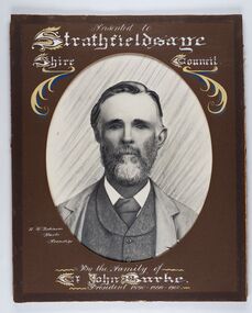
Photograph - Portrait of Councillor Burke
... from the Calder Highway to the Coliban and Campaspe Rivers... an area of 601 square kilometres and extended from the Calder ...The district of Strathfieldsaye was proclaimed in 1861 and named a Shire on the 17th September in 1866. It remained a shire until amalgamation in 1994 when it became part of the City of Greater Bendigo. The shire was located 8 km to the south- east of Bendigo and covered an area of 601 square kilometres and extended from the Calder Highway to the Coliban and Campaspe Rivers. The shire's administration centre was in Strathfieldsaye until 1972 when new offices were opened in Kennington. Framed black and white head and shoulder portrait of Councillor Burke with hand coloured and drawn detail. Profile centre facing with beard. Cut oval brown mount decorated with text and fscrolls. Hand written title top and lower centre. Wooden frame with detail and gold inner.Presented to Strathfieldsaye / shire Council / w. H. robinson / Photo / Bendigo / By the family of / Cr John Burke / President 1890 - 1899 - 1900strathfieldsaye shire council, councillor burke, president of strathfieldsaye shire -
 City of Greater Bendigo - Civic Collection
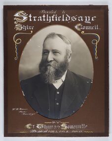
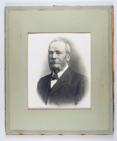
Photograph - Portrait of Councillor Thomas Somerville, W H Robinson
... from the Calder Highway to the Coliban and Campaspe Rivers... an area of 601 square kilometres and extended from the Calder ...The district of Strathfieldsaye was proclaimed in 1861 and named a Shire on the 17th September in 1866. It remained a shire until amalgamation in 1994 when it became part of the City of Greater Bendigo. The shire was located 8 km to the south- east of Bendigo and covered an area of 601 square kilometres and extended from the Calder Highway to the Coliban and Campaspe Rivers. The shire's administration centre was in Strathfieldsaye until 1972 when new offices were opened in KenningtonFramed black and white head and shoulder portrait of Councillor Somerville with hand drawn detail. Profile slightly to left, face has full beard. Cut oval brown mount decorated with text and scrolls. Hand written title top and lower centre.Presented to / Strathfieldsaye / Shire Council / W. H. Robinson / Photo / Bendigo / by / Cr Thomas Somerville / President 1892 - 3. 1901.2. 1910.11 strathfieldsaye shire council, councillor somerville, president of strathfieldsaye shire -
 City of Greater Bendigo - Civic Collection
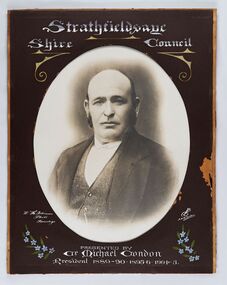
Photograph - Portrait of Councillor Michael Condon, W H Robinson
... from the Calder Highway to the Coliban and Campaspe Rivers... an area of 601 square kilometres and extended from the Calder ...The district of Strathfieldsaye was proclaimed in 1861 and named a Shire on the 17th September in 1866. It remained a shire until amalgamation in 1994 when it became part of the City of Greater Bendigo. The shire was located 8 km to the south- east of Bendigo and covered an area of 601 square kilometres and extended from the Calder Highway to the Coliban and Campaspe Rivers. The shire's administration centre was in Strathfieldsaye until 1972 when new offices were opened in KenningtonFramed black and white head and shoulder portrait of Councillor Condon with hand coloured and drawn detail. Profile slightly to left. No facial hair. Cut oval brown mount decorated with text, scrolls and flowers. Hand written title top and lower centre.Strathfieldsaye / Shire / Council / W. H. Robinson / Photo / Bendigo / JMB Gribble / Presented by / Cr Michael Condon / President 1889 - 90. 1895-6. 1904 - 5strathfieldsaye shire council, president of strathfieldsaye shire, councillor condon -
 City of Greater Bendigo - Civic Collection
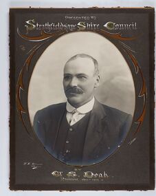
Photograph - Portrait of Councillor Doak, W H Robinson
... from the Calder Highway to the Coliban and Campaspe Rivers... an area of 601 square kilometres and extended from the Calder ...The district of Strathfieldsaye was proclaimed in 1861 and named a Shire on the 17th September in 1866. It remained a shire until amalgamation in 1994 when it became part of the City of Greater Bendigo. The shire was located 8 km to the south- east of Bendigo and covered an area of 601 square kilometres and extended from the Calder Highway to the Coliban and Campaspe Rivers. The shire's administration centre was in Strathfieldsaye until 1972 when new offices were opened in Kennington.Framed black and white head and shoulder portrait of Councillor Doak with hand coloured and drawn detail. Left facing profile with walrus moustache. Cut oval brown mount decorated with text and scrolls. Hand written title top and lower centre.Presented to / Strathfieldsaye Shire Council / W. H. Robinson / Photo / JMB Gribble / by Cr S. Doak / President 1911 - 1912strathfieldsaye shire council, president of strathfieldsaye shire, councillor doak -
 City of Greater Bendigo - Civic Collection
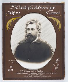
Photograph - Portrait of Councillor Sibley, W H Robinson
... from the Calder Highway to the Coliban and Campaspe Rivers... an area of 601 square kilometres and extended from the Calder ...The district of Strathfieldsaye was proclaimed in 1861 and named a Shire on the 17th September in 1866. It remained a shire until amalgamation in 1994 when it became part of the City of Greater Bendigo. The shire was located 8 km to the south- east of Bendigo and covered an area of 601 square kilometres and extended from the Calder Highway to the Coliban and Campaspe Rivers. The shire's administration centre was in Strathfieldsaye until 1972 when new offices were opened in KenningtonFramed black and white head and shoulder portrait of Councillor Sibley with hand coloured and drawn detail. Profile slightly to left with walrus moustache and beard. Cut oval brown mount decorated with text, flowers and scrolls. Hand written title top and lower centre.Strathfieldsaye / Shire Council / W m Robinson / Photo / Bendigo / J N B Gribble / Cr Robert R Sibley / First President Chairman of the Road Board 1865 - 5 / President 1866 - 1869 / With Mrs Sibley's Complimentsstrathfieldsaye shire council, councillor sibley, president of strathfieldsaye shire -
 City of Greater Bendigo - Civic Collection
Photograph - Portrait of Councillor Long, Talma & Co
... from the Calder Highway to the Coliban and Campaspe Rivers... an area of 601 square kilometres and extended from the Calder ...The district of Strathfieldsaye was proclaimed in 1861 and named a Shire on the 17th September in 1866. It remained a shire until amalgamation in 1994 when it became part of the City of Greater Bendigo. The shire was located 8 km to the south- east of Bendigo and covered an area of 601 square kilometres and extended from the Calder Highway to the Coliban and Campaspe Rivers. The shire's administration centre was in Strathfieldsaye until 1972 when new offices were opened in Kennington.Framed black and white head and shoulder portrait of Councillor Long. Profile to left with walrus moustache and mutton chops. Cut olive retangle mount. Verso; Long. On under board which has photograph attached; Talma & Co. / 119 Swanston St., / Melbournestrathfieldsaye shire council, councillor long -
 City of Greater Bendigo - Civic Collection
Photograph - Portrait of Councillor Hargraves, Bartlett Bros
... from the Calder Highway to the Coliban and Campaspe Rivers... an area of 601 square kilometres and extended from the Calder ...The district of Strathfieldsaye was proclaimed in 1861 and named a Shire on the 17th September in 1866. It remained a shire until amalgamation in 1994 when it became part of the City of Greater Bendigo. The shire was located 8 km to the south- east of Bendigo and covered an area of 601 square kilometres and extended from the Calder Highway to the Coliban and Campaspe Rivers. The shire's administration centre was in Strathfieldsaye until 1972 when new offices were opened in KenningtonFramed black and white head and shoulder portrait of Councillor Hargraves. Profile slightly to right with walrus moustache. Cut rectangle brown mount decorated with coloured text and scrolls. Hand written title top and lower centre.Strathfiledsaye Shire Council / Cr John Hargreaves / President 1919 - 20 1928 - 29 / Presented by his Wife & Familystrathfieldsaye shire council, president of strathfieldsaye shire, councillor hargreaves -
 City of Greater Bendigo - Civic Collection
Photograph - Strathfieldsaye Councillor Group Portrait, D.G. Coope & Son - Framers
... from the Calder Highway to the Coliban and Campaspe Rivers... from the Calder Highway to the Coliban and Campaspe Rivers ...The district of Strathfieldsaye was proclaimed in 1861 and named a Shire on the 17th September in 1866. It remained a shire until amalgamation in 1994 when it became part of the City of Greater Bendigo. The shire was located 8 km to the south- east of Bendigo and covered an area of 601 square kilometres and extended from the Calder Highway to the Coliban and Campaspe Rivers. The shire's administration centre was in Strathfieldsaye until 1972 when new offices were opened in Kennington.Silver gelatin framed photographic group portrait of fifteen men taken in the alcove of the Strathfieldsaye Shire Hall. Four men are seated and eleven are standing. Photograph is attached directly to cream mount card. Handwritten note with photograph: 1/ John Burke, 2/ (?), 3/ (?), 4/ RHS Abbott, 5/ M Brennan, 6/(?) 7/(?) 1/. M Condon? 2/ (?) 3/ M Burns, 4/(?) Gentlemen at back are probably council staff.shire of strathfieldsaye, strathfieldsaye shire council, president of strathfieldsaye shire, councillor john burke, councillor r.h.s. abbott, councillor brennan, councillor condon, councillor m burns -
 City of Greater Bendigo - Civic Collection
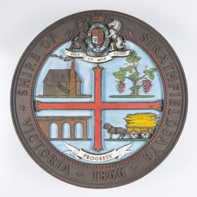
Sign - Shire of Strathfieldsaye Coat of Arms
... from the Calder Highway to the Coliban and Campaspe Rivers... an area of 601 square kilometres and extended from the Calder ...The district of Strathfieldsaye was proclaimed in 1861 and named a Shire on the 17th September in 1866. It remained a shire until amalgamation in 1994 when it became part of the City of Greater Bendigo. The shire was located 8 km to the south- east of Bendigo and covered an area of 601 square kilometres and extended from the Calder Highway to the Coliban and Campaspe Rivers. The shire's administration centre was in Strathfieldsaye until 1972 when new offices were opened in Kennington. This coat of arms was commissioned for the front of the shire hall building.Brass painted coat of arms or emblem within a circle of the Shire of Strathfieldsaye. Outer rim contains text: SHIRE OF STRATHFIELDSAYE VICTORIA 1866 with the shield of the monarch of the United Kingdom centre top. The shield is divided into four parts with images reflecting the leading industries of the time; wine growing, mining, farming and tanning. The motto PROGRESS is depicted lower centre of shield. SHIRE OF STRATHFIELDSAYE / VICTORIA / 1866 / PROGRESSshire of strathfieldsaye, city of greater bendigo amalgamation, city of greater bendigo signs -
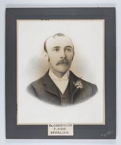 City of Greater Bendigo - Civic Collection
Photograph - Portrait of Councillor Orr, The Yeoman Studios, Ex. Councillor / F. Orr / Eppalock
... from the Calder Highway to the Coliban and Campaspe Rivers... an area of 601 square kilometres and extended from the Calder ...The district of Strathfieldsaye was proclaimed in 1861 and named a Shire on the 17th September in 1866. It remained a shire until amalgamation in 1994 when it became part of the City of Greater Bendigo. The shire was located 8 km to the south- east of Bendigo and covered an area of 601 square kilometres and extended from the Calder Highway to the Coliban and Campaspe Rivers. The shire's administration centre was in Strathfieldsaye until 1972 when new offices were opened in Kennington. Eppalock Ward is one of three wards in the Greater Bendigo municipality which includes the former Strathfieldsaye Shire. Framed black and white head and shoulder portrait with hand coloured detail. Man with profile slightly to right, walrus moustache, image encircled. Photograph is attached to mount card. Hand written title lower centre.Ex. Councillor / F. Orr / Eppalock / The / Yeoman / Studiosshire of strathfieldsaye, councillor orr