Showing 4539 items
matching canterbury centre
-
 Canterbury History Group
Photograph - Canterbury History Group meeting, early 1990's
... at Canterbury Neighbourhood Centre, Baptist Church, early 1990's, part... at Canterbury Neighbourhood Centre, Baptist Church, early 1990's, part ...Photo of an early Canterbury History Group meeting at Canterbury Neighbourhood Centre, Baptist Church, early 1990's, part of the group close-up.a black and white photoedie prest, pat trevare, rosemary lavington, des roman, jenny fullard -
Canterbury History Group
Photograph - Canterbury History Group meeting, early 1990's
... at Canterbury Neighbourhood Centre, Baptist Church, early 1990's, part... at Canterbury Neighbourhood Centre, Baptist Church, early 1990's, part ...Photo of an early Canterbury History Group meeting at Canterbury Neighbourhood Centre, Baptist Church, early 1990's, part of the group, enlarged photo of #3.a black and white photoedie prest, pat trevare, rosemary lavington, des roman, jenny fullard -
 Surrey Hills Historical Society Collection
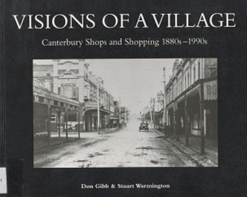
Book, Visions of a Village : Canterbury shops and shopping 1880s-1990s, 1995
... in the shopping and service centre of Canterbury and Maling Roads... in the shopping and service centre of Canterbury and Maling Roads... centre of Canterbury and Maling Roads in Canterbury from ...Focussing on the growth and activities that took place in the shopping and service centre of Canterbury and Maling Roads in Canterbury from the 1880s to the present, it is partly a guide book to the present buildings of the centre through the streetscapes and brief lives of each of the premises.Focussing on the growth and activities that took place in the shopping and service centre of Canterbury and Maling Roads in Canterbury from the 1880s to the present, it is partly a guide book to the present buildings of the centre through the streetscapes and brief lives of each of the premises. illus. of streetscapes, indexshops, canterbury, maling road, (mr) george robinson, rochester road, j weymouth, railways, m white, hindson buildings, (mrs) - hillier, f g wilson, s huckerby, g cox, (mr) george cornell, lawson brothers, retail trade, commercial development -
 Surrey Hills Historical Society Collection
Book, Visions of a Village : Canterbury shops and shopping 1880s-1990s, 1995
... in the shopping and service centre of Canterbury and Maling Roads... in the shopping and service centre of Canterbury and Maling Roads... centre of Canterbury and Maling Roads in Canterbury from ...Focussing on the growth and activities that took place in the shopping and service centre of Canterbury and Maling Roads in Canterbury from the 1880s to the present, it is partly a guide book to the present buildings of the centre through the streetscapes and brief lives of each of the premises.Focussing on the growth and activities that took place in the shopping and service centre of Canterbury and Maling Roads in Canterbury from the 1880s to the present, it is partly a guide book to the present buildings of the centre through the streetscapes and brief lives of each of the premises. illus. of streetscapes, indexshops, canterbury, maling road, (mr) george robinson, rochester road, j weymouth, railways, m white, hindson buildings, (mrs) - hillier, f g wilson, s huckerby, g cox, (mr) george cornell, lawson brothers, retail trade, commercial development -
Canterbury History Group
Photograph - Canterbury History Group meeting, early 1990's
... at Canterbury Neighbourhood Centre, Baptist Church, early 1990's, part... at Canterbury Neighbourhood Centre, Baptist Church, early 1990's, part ...Photo of an early Canterbury History Group meeting at Canterbury Neighbourhood Centre, Baptist Church, early 1990's, part of the group, taken from the rear, showing president Colleen Morgan standing at front.a black and white photocolleen morgan -
 Melbourne Legacy
Photograph, Legacy 50th Anniversary, 1973
... Vivian Bullwinkel. Chaucers was a reception and conference centre... Bullwinkel. Chaucers was a reception and conference centre ...Photos of the 50th Anniversary Dinner on 6 October 1973 held at Chaucers. (date to be verified) 00454.1 a view of the high table. 00454.2 shows a table with Ivan Layton and Matron Vivian Bullwinkel. Chaucers was a reception and conference centre in Canterbury, Melbourne, before it was sold in 1999 after operating 28 years (Telegraph news article from web). Photos came from an envelope marked P1 Federal Conference 1973 / 50 Year anniversary / 1983 Morewell / 1973 Legacy March ANZAC Day, 50 yr celebration, inclusion in ANZAC Day March authority of RSL". See items 00451,00452,00453, 00391. A record of a dinner marking the 50th anniversary of Legacy during the Golden Jubilee year 1973.Black and white photo x 2 of a dinner for the 50th anniversary of Legacy in 1973.Both stamped "This Photograph is the compliments of the Ministry of Tourism, Government of Victoria. Please acknowledge Michael Cheshire" in grey ink. 00454.1 Label on front says "Jubilee Dinner at Chaucers". 00454.2 Label on front says "Ivan Layton and Matron Vivian Bullwinkel"golden jubilee, 50th anniversary, ivan layton -
 Melbourne Legacy
Photograph, Legacy 50th Anniversary, 1973
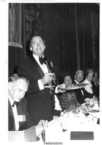
... and conference centre in Canterbury, Melbourne, before it was sold... and conference centre in Canterbury, Melbourne, before it was sold ...Photos of the 50th Anniversary Dinner on 6 October 1973 held at Chaucers. (date to be verified). 00453.1 shows the President Geoff Handbury making a speech. 00453.2 shows John Flynn, the President of Colac branch making a speech. Chaucers was a reception and conference centre in Canterbury, Melbourne, before it was sold in 1999 after operating 28 years (Telegraph news article from the web). Photos came from an envelope marked P1 Federal Conference 1973 / 50 Year anniversary / 1983 Morewell / 1973 Legacy March ANZAC Day, 50 yr celebration, inclusion in ANZAC Day March authority of RSL". See items 00451,00452, 00391. A record of a dinner marking the 50th anniversary of Legacy during the Golden Jubilee year 1973.Black and white photo x 2 of speeches at Legacy 50th anniversary dinner.Both stamped "This Photograph is the compliments of the Ministry of Tourism, Government of Victoria. Please acknowledge Michael Cheshire" in grey ink. 00453.1 Label on front says 'President'. On reverse 'Legacy Conference Jubilee Dinner at Chaucers 1973. Geoff Handbury and John Flynn (Colac)' in blue pen. 00453.2 Label on front says 'Toast to Legacy L/John Flynn, President Colac'.golden jubilee, 50th anniversary, geoff handbury -
 Ringwood and District Historical Society
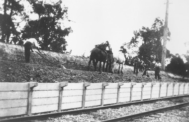
Photograph, Construction of Heathmont railway station by the Wieland family, 1926. Four photographs
... railway station platform by Wieland brother 1926. Canterbury Rd... by Wieland brother 1926. Canterbury Rd in Centre Background, Bridge ...3 large black and white photographs (1957-001 to -003) 25x15cms mounted on white board, plus one small B&W photograph (1957-004) 11.2 c 6.7 cms)On 1957-001: Typed below photograph, "Building Heathmont railway station platform by Wieland brother 1926. Note use of plough." On 1957-002: Typed below photograph, "Building Heathmont railway station platform by Wieland brother 1926. Heathmont Rd in Background." On 1957-003: Typed below photograph, "Building Heathmont railway station platform by Wieland brother 1926. Canterbury Rd in Centre Background, Bridge to left." On Reverse of 1957-004, handwritten: "All the men in Heathmont made the Heathmont Station. The one with X over him is dad. This was taken when they were making it before it was burned down, Ruby, xxxxxxxXXX" -
 Melbourne Legacy
Photograph, Legacy 50th Anniversary, 1973
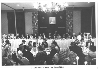
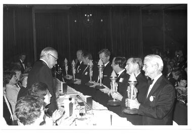
... and conference centre in Canterbury, Melbourne, before it was sold... and conference centre in Canterbury, Melbourne, before it was sold ...Photos of the 50th Anniversary Dinner on 6 October 1973 held at Chaucers during the Legacy Conference. (date to be confirmed) 00452.1 shows 6 men with Legacy Torches lined up along the front of the high table. A caption found when the photo was published elsewhere says 'On the occasion of the Golden Jubilee Annual Conference of Legacy Clubs of Australia, held in Melbourne in October 1973, the Chairman of the Legacy Co-ordinating Council, Legatee George Cowan, presented an illuminated Torch emblem to the President of the capital city Legacy Club of each of the six States. Members of Legacy are determined that the Torch shall continue to burn brightly throughout Legacy's second half century of service to dependants of deceased ex-servicemen.' Other photos are of table groups or room shots. Chaucers was a reception and conference centre in Canterbury, Melbourne, before it was sold in 1999 after operating 28 years (Telegraph news article from web). Photos came from an envelope marked P1 Federal Conference 1973 / 50 Year anniversary / 1983 Morewell / 1973 Legacy March ANZAC Day, 50 yr celebration, inclusion in ANZAC Day March authority of RSL". See items 00451, 00391. A record of a dinner marking the 50th anniversary of Legacy during the Golden Jubilee year 1973.Black and white photo x 6 of 50th anniversary dinner.Stamped "This Photograph is the compliments of the Ministry of Tourism, Government of Victoria. Please acknowledge Michael Cheshire" in grey ink and 6 October 1973 in purple ink.golden jubilee, conference, legatee function -
 Ringwood and District Historical Society
Photographs, Agfa, Heathmont shops and locations in Dec 1999 (25 Photos), 29-Dec-99
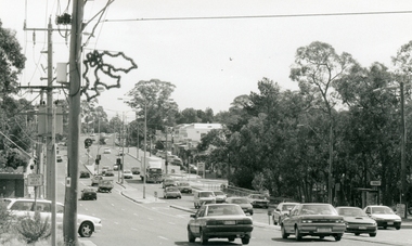
Photographs (25) B&W of Heathmont shops, buildings, parks, train tracks, scout hall, toilet block.Canterbury Road, Heathmont, looking south-west (3226_001.jpg); Southern part of Heathmont shopping centre, looking west (3226_002.jpg); Canterbury Road, Heathmont, looking north (3226_003.jpg); McLean's Real Estate, Heathmont (3226_004.jpg); Northern part of Heathmont shopping centre (3226_005.jpg); Heathmont shops (3226_006.jpg); Heathmont shops (3226_007.jpg); Heathmont dry cleaners (3226_008.jpg); Heathmont newsagency (3226_009.jpg); Heathmont Mother's General Store (3226_010.jpg); The Boulevard, Heathmont (3226_011.jpg); Heathmont train (3226_012.jpg); Heathmont public toilets (3226_013.jpg); Heathmont railway crossing, Allens Road (3226_014.jpg); Heathmont bicycle path, near Allens Road (3226_015.jpg); Cnr Allens Road and The Boulevard, Heathmont (3226_016.jpg); Heathmont bicycle path, near Allens Road (3226_017.jpg); Oval No. 1, HE Parker Reserve, Heathmont (3226_018.jpg); Cnr Allens Road and The Boulevard, Heathmont (3226_019.jpg); 2nd Ringwood Scout Group, HE Parker Reserve (3226_020.jpg); Railway line looking towards Heathmont Station (3226_021.jpg); HE Parker Reserve sign (3226_022.jpg); Heathmont supermarket (3226_023.jpg); Heathmont greengrocers (3226_024.jpg); Heathmont railway crossing, near Allens Road (3226_025.jpg) -
 Bendigo Military Museum
Uniform - BUTTON & COLOUR PATCH, 1914 -18
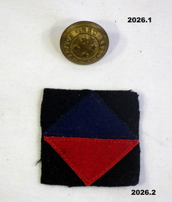
The colour patch is 2nd Battalion Canterbury Infantry Regiment New Zealand Military Forces. They belonged to Harry Thompson who came from Sebastion near Bendigo and enlisted in New Zealand. Refer 323.3, 1258, 2027..1) Button, metal, round with 4 stars in the centre with "New Zealand Forces" around the outside. .2) Canterbury Regiment colour patch, felt material, square shaped black backing with central diamond shape, dark blue over red.uniforms-military-accessories, metalcraft-brassware, manchester-trimmings -
 Ringwood and District Historical Society
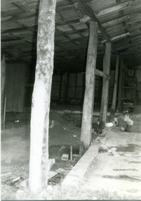
Photograph-B&W, Hill's Dairy, Canterbury Road, Ringwood 1989-Barn interior, 6/07/1989
Hill's Dairy, Canterbury Road, Ringwood 1989- Roof supports in the centre of the barn. Taken at last two posts. East of those in picture 4 (RDHS Catalogue No 6502-004) on their northern sideRoof supports in the centre of the barn / Taken at last two posts / East of those in picture 4 (RDHS Catalogue No 6502-004) on their northern side -
 Ringwood and District Historical Society
Pamphlet, Land Sale Brochure Titled Eureka Plan Book - Seven Delightful & Valuable Ringwood Estates - circa 1925
Twenty page land sale brochure including photographs, subdivision features and local facilities. Additional flyer with conditions of sale and prices for estate blocks.Seven delightful and valuable Ringwood Estates called Bestpart, Paradise, Hill Top, Greenwood, Creek, Station, and School Estates. These nestle amidst the hills and valleys of beautiful Ringwood district. Also Goodluck Estate at Clarinda. Pamphlet marked as being From Mr. Farmer, No. 5 Flinders Court, Melbourne. Phone 988, 989 Central, or 55 Ringwood after 7 p.m. Plan of Ringwood School Estate includes William Street (later Kendall Street), Greenwood Avenue, Alton Street and Locke Street. Plan of Bestpart Estate, Ringwood, includes Bedford Road, Wilana Street, Greenwood Avenue, Caroline Street, Henry Street and Haig Street. Plan of Ringwood Station Estate includes Pitt Street, Bedford Road, Greenwood Avenue, Station Street, William Street (later Kendall Street, James Street, Wantirna Road, Caroline Street, Henry Street, Ellison Street and Haig Street. Plan of Geenwood Estate, Ringwood, includes Prussian Road (later Geenwood Avenue). Plan of Paradise Estate, Ringwood, includes Canterbury Road, Dandenong Road (Wantirna Road), Luck Street and Paradise Road. Plan of Creek Estate, Ringwood, includes Dandenong Creek, Wantirna Road and Gordon Crescent. Plan of Hill Top Estate, Ringwood (later Heathmont area), includes Heathmont Railway Station, Heathmont Road, Balfour Avenue, Lilian Street, Edith Street, Edna Street and Great Ryrie Street. Plan of Goodluck Estate, Clarinda, includes Talbot Avenue, Good Street, Luck Street, and Centre Road in locality plan between Oakleigh and Clayton Railway Stations. -
 Ringwood and District Historical Society
Flyer, Stillwell & Stephens Pty. Ltd, Brochure - Multiple Properties for Public Auction at Box Hill, Ringwood, Wonga Park and Clarinda - 28th November, 1934
Seven-page brochure advertising Mortgagees' Realising Sale by Public Auction on Wednesday, 28th November, 1934 for properties at Box Hill, Ringwood, Wonga Park, and Clarinda (via Oakleigh), including photographs, property descriptions, and terms of sale.Auction Commencing at 2.15 p.m. in the Orient Line Auction Rooms, 352 Collins Street, Melbourne. Solicitors: Messrs. Madden, Butler, Elder & Graham, 406 Collins Street, Melbourne. (Agents) H.P. Knight & Co. Property Salesmen and Subidivisional Experts, 315 Collins Street, Melbourne, 'Phones: Central 10615, 10616. Attractive Residential, Orchard, and Market Garden Properties, and Public Hall and School Rooms. 1. Wonga Park via Ringwood - "Holme Bush" off Warrandyte Road, Part of Lots 14 and 15, Ringwood Orchard Estate, approximatgely three miles (north) of Ringwood Railway Station - 64 Acres. 2. 17 Bishop Street, Box Hill - timber residence. 3. Greenwood Avenue, Ringwood - On East Side, 150 feet 3 inches South of Bedford Road - timber attic residence. 4. Ringwood - Wantirna Road, South-east corner of Canterbury Road - Orchard Property of approx. 11-1/2 Acres. 5. Box Hill - Whitehorse Road, South-east corner of Linsley Street - Timber building utilised as a Public Hall and Private School. 6. Clarinda vic Oakleigh, Talbot Crescent, off Centre Road - Home on 10 acres of land. -
 Ringwood and District Historical Society
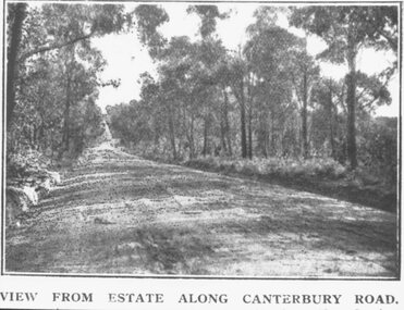
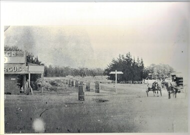
Photograph, Coleman's Heathmont Estate Sale, 15/12/1923. Looking west along Canterbury Road Heathmont. Railway bridge is situated at foot of hill
Printing below photograph reads, "View from estate along Canterbury Road." Typed on backing sheet below, "Canterbury Rd. Heathmont looking towards city. Railway bridge at foot of hill 1923. Area in foreground now shopping centre both sides of road." -
 Ringwood and District Historical Society
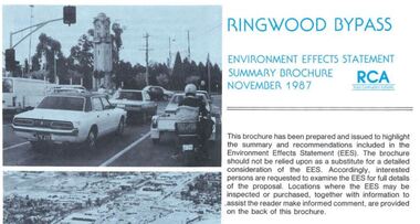
Newsletter, Ringwood Bypass Environment Effects Statement Summary Brochure - November 1987
8-page A4 size brochure issued by Road Construction Authority reporting on the proposed Ringwood Bypass. Topics include Community Consultation, Estimated Capital Costs, Traffic Effects, Property Effects, Mullum Mullum Creek, Landscape Development, Pedestrian/Bicycle Access, Noise, Air Quality, Compatability with Ringwood District Centre Development, Vehicle & Traffic Aspects, Lighting, Construction Impacts, Extension to Canterbury Road, Public Transport. -
 Bendigo Historical Society Inc.
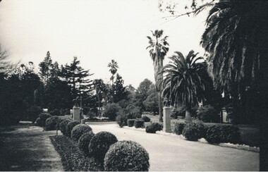
Photograph - CANTERBURY GARDENS: EAGLEHAWK
Black and white photograph of garden, tall pines in background, palms in foreground. Eaglehawk statues on plinths in centre, gravel path with trimmed shrubs each side. On back in pencil 'Canterbury Park' ' Canterbury Gardens Eaglehawk entrance' James Lerk.? Leo Hughesplace, public gardens, canterbury gardens, eaglehawk -
 Scout Heritage Victoria Centre and Archives
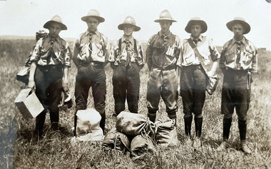
Photograph - 1st Canterbury Scouts 1921, 1st Canterbury Scouts at Bullen Camp, 1921
From Photo Album of 1st Kew ScoutsPhoto of 1st Canterbury Scouts at Camp at Bulleen, Victoria - 1921scouts, kew, canterbury -
 Canterbury Primary School
Photograph, Broothorn Studios
Studio portrait of Flo Davies.First student enrolled at the new Canterbury State primary school.Hand tinted portrait photograph of Florence (Flo) Davies, reputed first student enrolled at Canterbury Primary SchoolBottom left corner "Broothern Studios" Bottom right corner "230 Collins St. M" (corner torn) Rear centre "Florence Emily/Davies (handwritten)photograph, school, student, canterbury -
 Whitehorse Historical Society Inc.
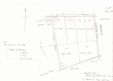
Document, Subdivisions 1859, nd
Sketch map of subdivisions of 1859.Sketch map of subdivisions of 1859. Allotment 126 and portions of 125, 126 and 130, including 'Village of Studley', 'Village of New Brunswick' and two unnamed. Information from Mr McComb, retired surveyor; sketch and notes. Areas near railway line east of Mitcham Station and North East corner of Canterbury and Mitcham Roads. Refer map A - SP 110.Sketch map of subdivisions of 1859.land subdivision, heatherdale road, mitcham, purches street, mitcham road, vermont, canterbury road, whitehorse road, brunswick road, creek road, centre road, studley village, new brunswick village -
Whitehorse Historical Society Inc.
Document, Blackburn South, 1989
Extract from 'Mardie' by Beatrice Pooley, 1989, describing the beginnings of the Blackburn South Shopping Centre.Extract from 'Mardie' by Beatrice Pooley, 1989, describing the beginnings of the Blackburn South Shopping Centre.Extract from 'Mardie' by Beatrice Pooley, 1989, describing the beginnings of the Blackburn South Shopping Centre.canterbury road, blackburn south, pooley, beatrice, blackburn south shopping centre -
Whitehorse Historical Society Inc.
Article, Vermont Shopping Centre, 1996
... Article featuring Vermont Shopping Centre, corner... Article featuring Vermont Shopping Centre, corner of Canterbury ...Article featuring Vermont Shopping Centre, corner of Canterbury and Boronia Roads. Bruno Tassone runs the newsagency and Joe Italiano the greengrocery. Also advertisements for other Vermont businesses.Article featuring Vermont Shopping Centre, corner of Canterbury and Boronia Roads. Bruno Tassone runs the newsagency and Joe Italiano the greengrocery. Also advertisements for other Vermont businesses.Article featuring Vermont Shopping Centre, corner of Canterbury and Boronia Roads. Bruno Tassone runs the newsagency and Joe Italiano the greengrocery. Also advertisements for other Vermont businesses.shops, vermont shopping centre, tassone, bruno, italiano, joe, vermont fuel and produce, vermont baked ham, vermont bakery, vermont fruit supply, mi va pizza, vermont, videoboom, vermont colour spectrum laboratories, mie-ray hair and beauty, vermont pharmacy, gerard audio visual, principal hairdressing, j.c. auto centre, vermont post office, vermont cellars, nurlendi panels -
Whitehorse Historical Society Inc.
Document, Enrolment records, 1967 - 1993
Enrolments records for Holbury Pre-School Centre, 1967 - 1993. Includes names and addresses of all student, also parents' names and father's occupation until 1974.Enrolments records for Holbury Pre-School Centre, 1967 - 1993. Includes names and addresses of all student, also parents' names and father's occupation until 1974. Located Cr Holland and Canterbury Roads until 1970, then in Raleigh Street, Blackburn South.Enrolments records for Holbury Pre-School Centre, 1967 - 1993. Includes names and addresses of all student, also parents' names and father's occupation until 1974.holbury pre-school centre, holland road, blackburn south, canterbury road, raleigh street, no 29. -
Whitehorse Historical Society Inc.
Pamphlet, Stonestown, c. 1959
Brochure on a proposed shopping centre on the southwest corner of Canterbury and Springvale Roads Forest Hill.Brochure on a proposed shopping centre on the southwest corner of Canterbury and Springvale Roads Forest HillBrochure on a proposed shopping centre on the southwest corner of Canterbury and Springvale Roads Forest Hill.shopping centres, springvale road, forest hill, canterbury road, forest hill, stonestown -
 Whitehorse Historical Society Inc.
Photograph, Site of Barnard's Corner Store
... Corner Store (2 copies) Boronia Road and Canterbury Road, Vermont... gates on back centre of photograph in Canterbury Road ...Laser Print of black and white photo of Site of Barnard's Corner Store (2 copies) Boronia Road and Canterbury Road, Vermont. (Mounted) Barnard's Store was on the south-west corner of Canterbury Road and L.L. Vale Road (Boronia Road) Vermont. The old store was run by Miss Barnard. Mr Barnard had a Farriers Shop at the back of the store. The white gates on back centre of photograph in Canterbury Road is entrance to Uplands, home of Edward Bishop and Dr. Stephens. White fence on right hand side of photograph is entrance to home of Mr. & Mrs. Tilson who was a market gardener and orchardist.barnards corner store, uplands, vermont, stephens, dr., tilson, mr., tilson mrs, bishop, edward -
 Whitehorse Historical Society Inc.
Photograph, Old Dam - Corner of Blackburn and Canterbury Road, c1910
Original photo at Blackburn Lake Education Centre. Dorothy Meagher loaned photo so a print could be made.Black and white photograph of children playing on the dam on the corner of Blackburn and Canterbury Roads, Blackburn. The Bellbird Hospital is now on the site.canterbury road, blackburn, blackburn road, blackburn lake education centre, meagher, dorothy, bellbird private hospital -
 Whitehorse Historical Society Inc.
Photograph, Old Dam corner Blackburn and Canterbury Roads, c1910
Original photo at Blackburn Lake Education Centre. Dorothy Meagher loaned photo so a print could be made.Black and white photograph of dam being built on the south west corner of Canterbury and Blackburn Roads, Blackburn. Bellbird Hospital is now on this site.canterbury road, blackburn, blackburn road, blackburn lake education centre, meagher, dorothy, bellbird private hospital -
 Whitehorse Historical Society Inc.
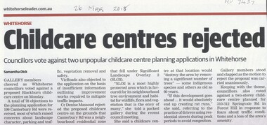
Article, Childcare Centres Rejected
... centre at 199 Canterbury Road, Blackburn and another at 310-312... Mitcham melbourne city of whitehorse child care centres canterbury ...Whitehorse councilors voted against a proposed childcare centre at 199 Canterbury Road, Blackburn and another at 310-312 Springvale Road, Forest Hill.Whitehorse councilors voted against a proposed childcare centre at 199 Canterbury Road, Blackburn and another at 310-312 Springvale Road, Forest Hill.Whitehorse councilors voted against a proposed childcare centre at 199 Canterbury Road, Blackburn and another at 310-312 Springvale Road, Forest Hill.city of whitehorse, child care centres, canterbury road, blackburn no. 199, springvale road, forest hill no 310 - 312 -
 Whitehorse Historical Society Inc.
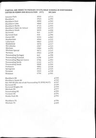
Document - Centenary History of State Education in Victoria, Victorian Education Department, Centenary History, 1973
Selected pages of schools in the Nunawading area from "Vision and Realisation". A Centenary History of State Education in Victoria. N.B. State schools are now called Primary SchoolsA list and description of schools in Whitehorse from "Vision and Realisation"A4 photocopy of 58 selected pages from "Vision and Realisation": a "Centenary History of State Education in Victoria" by the Victorian Education Department. Volume 3 dealing with schools in the Nunawading areavictorian education department, burwood east state school no.454, nunawading (sagoe common school) (box hill) no.463, nunawading (boroondara) catholic school no.464, nunawading state school (canterbury road) no.469, vermont state school. no 1022, burwood east state school no 461, nunawading north state school no 2242, mitcham state school no.2904, blackburn state school no.2923, blackburn open air school no.3850, blackburn south state school no. 4035, nunawading state school no.4190, forest hill state school no.4251, nunawading migrant centre no.4706, blackburn north state school no.4715, tally ho training farm no.3588, winlaton girls youth training centre no.4794, blackburn east state school no.4800, nunawading south state school no.4808, antonio park state school no.4844, blackburn lake state school no.4860, laburnun state school no.4863, mitcham special school no.4871, blackburn high school, blackburn south high school, mitcham high school, nunawading high school, vermont high school, mitcham technical school, primary schools, secondary schools, blackburn technical school