Showing 19401 items
matching coasts
-
 Running Rabbits Military Museum operated by the Upwey Belgrave RSL Sub Branch
Plaque
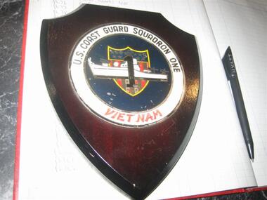
US Coast Guard Sqd Oneplaque -
 Ballarat Heritage Services
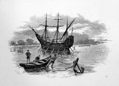
Image, Anchored Ship
First Published in Picturesque Atlas of Australia.Line drawing of a ship anchored on the coast.ship, exploration, immigration -
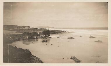
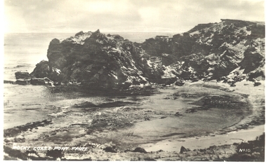 Port Fairy Historical Society Museum and Archives
Postcard - Photograph, Rocky Coast, Port Fairy
PhotographRocky Coast, Port Fairybeach, sea, seascape -
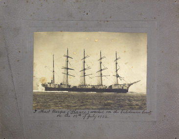 Mission to Seafarers Victoria
photograph, 5 mast barque (France) wrecked on the Caledonian coast on the 12th of July 1922, 12 July 1922
"France II" was an extremely large tall ship, square rigged as a five-masted steel-hulled barque. and belonging to the "Compagnie française de marine et de commerce" was a totally wrecked in a coral reef of Ouano on the coast of New Caledonia in the night between 11 and 12 July 1922. The France II was the second largest commercial merchant sailing ship ever built (hull length:142,2m).Black and white photograph mounted on grey cardboard depicting a sailing shipHandwritten in black ink at bottom on mount: "5 mast barque (France) wrecked on the Caledonian coast / on the 12th of July 1922"shipwreck, france, barque, new caledonia, ships, crews and ships, barque france, 1922 -
 Ballarat Heritage Services
Photograph - Image - Black and White, Portsea on Port Phillip Bay, c1950, c1950
A black and white image of the coast at Portsea, Victoria.beach, portsea, port phillip bay -
 Hand Tool Preservation Association of Australia Inc
Photographs
This item is part of the Thomas Caine Tool Collection, owned by The National Trust of Australia (Victoria) and curated by the Hand Tools Preservation Association of Australia.7 photos, jetty - ship - coast scenes -
Lakes Entrance Historical Society
Book, Loney, Jack, Australia's Shipwreck Coast, 1986
Stories of some of the shipwrecks around Australia's coastships and shipping -
 Phillip Island and District Historical Society Inc.
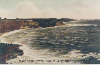
Photograph, Early 20th Century
One of a collection of photographs donated by Bruce BennettColoured copy of a postcard showing the coastal cliffs on Westernport with The Nobbies in the distance"Coast Scene, Cowes, Nobbies in Distance."phillip island coastline, cliffs and shoreline westernport, bruce bennett -
 National Wool Museum
Pennant
Queensland's GOLD COAST FUN IN THE SUNgold coast, queensland -
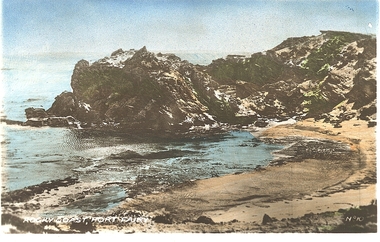 Port Fairy Historical Society Museum and Archives
Photograph - Postcard, Rocky Coast. Port Fairy
Hand coloured photograph of a rocky outcrop above a small sandy cove Rocky coast Port Fairy No !0beach, sea, seascape -
Glenelg Shire Council Cultural Collection
Souvenir - Tea Towel, n.d
Cotton tea towel. White background 'AUSTRALIA'S SHIPWRECK COAST' in black. Depictions in brown, of 4 shipwrecks, above depiction of Shipwreck Coast - Portland to Port Campbell. Bottom half of tea towel, has coloured depictions of various places on Shipwreck Coast. Black border. -
Glenelg Shire Council Cultural Collection
Souvenir - Tea Towel - Shipwreck Coast, n.d
Cotton tea towel. White background 'AUSTRALIA'S SHIPWRECK COAST' in black, black border. Depictions in brown of 4 shipwrecks, above depiction of Shipwreck Coast - Portland to Port Campbell. Bottom half of tea towel has coloured depictions of various places on shipwreck coast.souvenir, shipwreck coast, tea towel, domestic item -
 Phillip Island and District Historical Society Inc.
Photograph, Unknown
One of 6 photographs donated by M. BattyBlack & White photograph of the South Coast of Phillip Island.phillip island coastline, south coast phillip island, phillip island, m batty -
 Phillip Island and District Historical Society Inc.
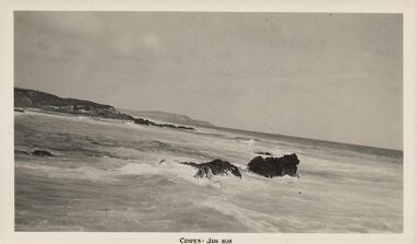
Photograph, 01/1938
One of 8 photographs donated by Joseph WhiteBlack & White photograph of the South Coast of Phillip Island"Cowes - Jan 1938"phillip island coastline, south coast phillip island, shoreline phillip island, joseph white -
 Phillip Island and District Historical Society Inc.
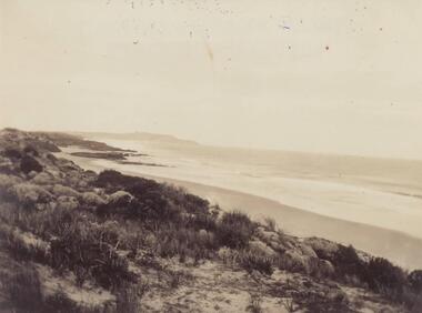
Photograph, Early 20th Century
One of a collection of 6 photographs donated by Mary KarneyBlack & White photograph of the South Coast of Phillip Islandphillip island coastline, south coast phillip island, mary karney -
 Victorian Interpretive Projects Inc.
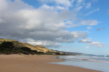
Photograph -Colour, Apollo Bay, Victoria, 2105, 25/01.2015
Apollo Bay is a coastal town in Victoria. A number of colour photographs of the coast at Apollo Bay, Victoria.apollo bay, coast, beach, sea, seaside, surf -
 Ballarat Heritage Services
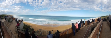
Digital photographs, Logans Beach Whalewatchers Panorama, c2010
Logan's Beach is known as a whale watching site. Colour panoramic photograph of the coast at Logan's beach, Warrnambool.warrnambool, coast, coastal, beach, seascape, whale watching, platform, logans beach -
 Ballarat Heritage Services
Digital photograph, Lisa Gervasoni, Portland, c2015
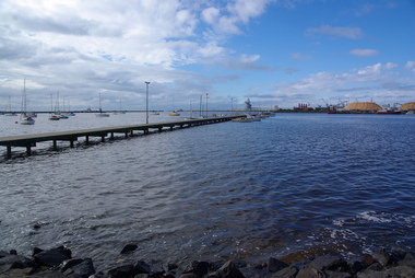
Colour photograph of the coast at Portland, looking towards the port.portland, heritage, port, bay, water -
 Federation University Art Collection
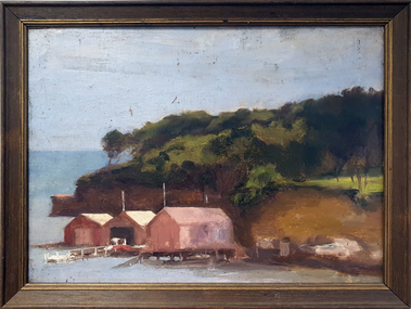
Painting - Oil on board, Robinson, John Braisted, 'Beaumaris' by John Braisted Robinson, 1929
John B. ROBINSON (c1877 -25 May1935) Born Ballarat, Victoria A latecomer to painting, John Robinson was known to periodically attend the Max Meldrum School. He joined the administrative staff of the Ballarat School of Mines somewhere around 1902, obtaining the position of Registrar. He stayed in the Schools employment for 35 years. His chief recreations were gardening and the study of art. "His many canvases reveal the sincerity of his work and represent a notable achievement from one who adopted art somewhat late in life. (Obituary, Ballarat School of Mines Students' Magazine, 1935) Robinson studied with Max Meldrum in Melbourne. This item is part of the Federation University Art Collection. The Art Collection features over 2000 works and was listed as a 'Ballarat Treasure' in 2007.Framed oil painting showing the coast and three boathouses.Verso underneath brown paper No 11 Beaumaris Artists Signation J.B. Robinsonart, artwork, john braisted robinson, beaumaris, seascape, max meldrum school, available -
 Bendigo Military Museum
Map - MAPS, EAST TIMOR, US Govt et al, 1975 - 1976
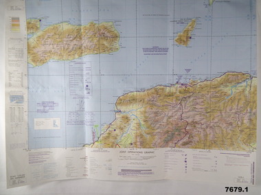
1. This is a coloured map. It's scale is 1.250,000 - called a jpoint operations graphic. It covers the North side of East Timor. Dili is in the centre. Its shows 4 Islands to the north of Timor. It shows Savu Fea, Ombai Strait, Wetar Strait. On bottom left of map it shows Batheade and the start of the New Border. Map - Series 159. Sheet 5C- 51-4. Edition 3-GSGS. 2. This is a coloured map. Its scale is 1.250,000 called a joint Operations Graphic. It manly covers West Timor. It shows Savu Sea in North and Timor Sea on south side. Series 1501. Sheet SC 51.7. Edition 3-GSGS. 3. This a coloured map. It's scale is 1.250,000. Joint operations graphic. This map shows the south side of East Timor and the Timor Sea. This map shows a highlighted New border. The major towns on South coast are KAMFNASA, BETANO. Map series 1501. Sheet SC 51-8. Edition 3 GSGS.1. Has highlighted "7 BSG" on coast. All maps show East Timor border highlighted in pink.east timor, maps, interfet -
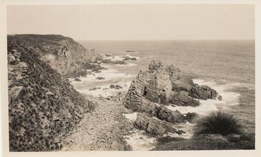
 Phillip Island and District Historical Society Inc.
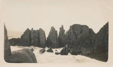
Photograph, The Pinnacles, Cape Woolamai
Pinnacles south side of Philip Island, Cape Woolamai. Part of the Jessie Smith Collection.Coastal view of The Pinnacles, Cape Woolamai - rocks at coast edge.local history, photographs, the pinnacles, cape woolamai, phillip island, coastal geography, jessie smith collection, stan mcfee -
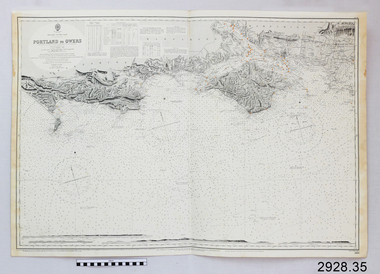 Flagstaff Hill Maritime Museum and Village
Document - Navigation Chart, Portland to Owers
British Admiralty Navigation Chart - Portland to Owers, England - South Coastwarrnambool, shipwrecked-coast, flagstaff-hill, flagstaff-hill-maritime-museum, maritime-museum, shipwreck-coast, flagstaff-hill-maritime-village, shipwrecked-artefact, navigation chart, british admiralty navigation chart, british admiralty, portland to owers -
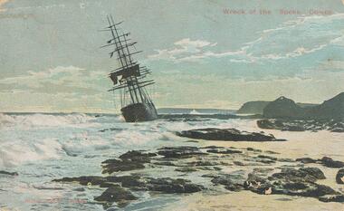 Phillip Island and District Historical Society Inc.
Photograph - Post Card, 1906
One of a collection of photographs donated by Shirley Peterson.Colour postcard of the wreck of the :Speke" on the south coast of Phillip Island in 1906."Wreck of the "Speke", Cowes" "Robb Bros. Cowes"wreck of the sailing ship "speke", phillip island coastline, phillip island, shirley peterson -
 Phillip Island and District Historical Society Inc.
Photograph, Unknown
One of 6 photograph donated by M. BattyBlack & White photograph of South Coast of Phillip Island with rocky outcrop.phillip island coastline, coastline - south coast, rocky outcrock phillip island, phillip island, m batty -
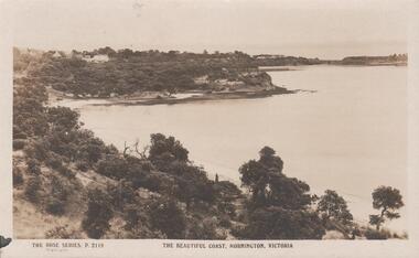 Bendigo Historical Society Inc.
Postcard - THE BEAUTIFUL COAST MORNINGTON ,VIC
The Beautiful Coast Mornington, Vic. To Florrie from Ada on their''Lovelly holiday''. -
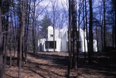 Robin Boyd Foundation
Slide, Robin Boyd, 1971
Colour slide in a mount. Unknown building, probably east coast USAMade in Australia / 15 / AUG 71M1slide, robin boyd -
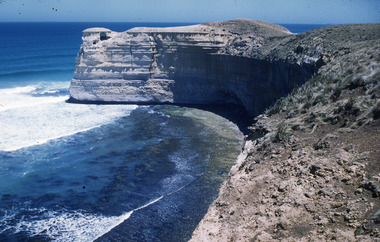 Robin Boyd Foundation
Slide, Robin Boyd
Colour slide in a mount. Shipwreck Coast, Great Ocean Road, Victoriaslide, robin boyd -
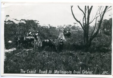 Orbost & District Historical Society
black and white photograph, late 19th century - early 20th century
Prior to the sealing of the Princes Highway west of Orbost, the road surface was anything but good, even by C1917 when cars started to use the road. From Orbost the old road via Marlo to Sydenham was abandoned for the new location which traversed more rugged country via Cabbage Tree, Bell Bird and Club Terrace to Cann River, and the reason for this diversion was on account of settlements being established at Murrungowar and Club Terrace, at which latter place there was a temporary rush to obtain gold. This road was constructed by the Public Works department and a maximum grade of 1 in 19 was adopted, and as speed was not to be catered for the grade followed in and out round the spurs and gullies, resulting in a maze of turns and twists which required a good deal of skill on the part of the horse driver to negotiate." - Bairnsdale Advertiser, Friday, May 2, 1947. (More information from Newsletter February 2010)n the late 1800's early 1900's transporting goods by road was difficult and at times impossible because roads as thoroughfares did not exist.The means of travelling along the roads in the 1800's was by bullock wagon, horse pulled dray, pack horse or simply by foot. This road is still in use in East Gippsland as a part of many four-wheel-drive touring routes.A large black / white photograph of two horse - drawn wagons on a narrow sandy bush track. It is surrounded by scrub. There is one man standing beside a horse not harnessed to a wagon.on front - "The Coast Road to Mallacoota from Orbost JPC" -
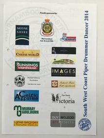 Warrnambool and District Historical Society Inc.
Document - South West Coast Piper Drummer Dancer 2014, 2014
This item advertises a performance by the Warrnambool & District Pipes & Drums in 2014. Many sponsors were gained. The Warrnambool Pipe Band was established in 1906. It went into recess from 1916 to 1835 when it was re-formed. Today it performs under the name of Warrnambool & District Pipes & Drums in the area.This item is of minor significance as a memento of the Warrnambool & District Pipes & Drums A page advertising a performance by the Warrnambool & District Pipes and Drums. It contains sixteen logos in colour including that of the Warrnambool and District Pipes and Drums . South West Coast Piper Drummer Dancer 2014warrnambool & district pipes and drums, wadpadi, south west coast piper drummer dancer -
Glenelg Shire Council Cultural Collection
Souvenir - Pen, n.d
Pen, biro, blue/black marbled, gold trims, gold lettering on cap.Front: 'Portland Coast Region Water Authority' - gold