Showing 383 items matching "conservation photographs"
-
 The Beechworth Burke Museum
Photograph, 25 October 1930
Taken on 25 October 1930, various houses with the Hume Dam under construction are depicted in the background. The construction of the Hume Dam took place from 1919 to 1936. At the time of construction, it was the second largest dam in the world. It was also one of the earliest civil projects developed after the Federation. Some of the Dam workers consisted of World War I veterans. Dam workers often settled their families in Mitta Junction Village and Wodonga. Archaeological surveys were completed by Austral Archaeology, which was done when the Department of Land & Water Conservation was doing work to improve Hume Dam. The archaeological report that came out of the survey recommended three sites of interest where archaeological excavation should be done: Camp Ganger’s Quarters, Stableman’s Quarters, and the Industrial Dump. The excavation uncovered artefacts. Mitta Mitta: Mitta Mitta is situated between Mount Welcome and Mount Misery. It is named after the river that explorers Hume and Hovell discovered in 1824. The town would eventually become a huge gold mining town. Mitta Mitta is called Midamodunga by the local Indigenous peoples Wodonga: Wodonga is situated on the Murray River and is part of North East Victoria. Hume and Hovell: Hamilton Hume (1979-1873) and William Hilton Hovell (1786-1875). W. H. Hovell was born in Norfolk England and Hume was born in Parramatta, New South Wales Hovell and Hume undertook an exploration journey in 1824 and thought they discovered a river, which turned out to be the Murray River. They returned home in 1825, but returned to the area in 1826 and discovered coal in the area. This photo is historically significant as it shows the Hume Dam under construction in 1930. The Dam was named after Hamilton Hume, who is an important historical figure for this area as he helped discover the area where resources were found. Black and white rectangular photograph printer unmountedReverse: 1997.3145/ 84-20-2construction, houses, veterans, mitta junction village, hume dam, world war i, federation, wodonga, archaeological survey, excavation, austral archaeology, department of land & water conservation, camp ganger's quarter's, stableman's quarters, industrial dump, artefacts, mitta mitta, mount welcome, mount misery, murray river, hamilton hume, william hilton hovell, hume and hovell expedition -
 Orbost & District Historical Society
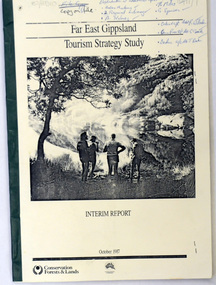
book / document, Far East Gippsland Tourism Strategy Oct 1987, October 1987
The project team for this document comprised E. Beacham, T. Claridge, B. Ebbs, C. Wilso. and J. Cristofaro.This booklet is a useful refernce tool.A document of 86 pp, titled Far East Gippsland Tourism Strategy Study Interim Report October 1987. it has a cream cover and black binding with a b/w photograph of four people in a bushland setting. It contains fold-out maps.tourism-east-gippsland -
 Orbost & District Historical Society
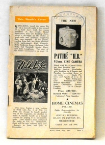
maagazine, Wild Life, July 1951
This magazine promotes the protection of wildlife and the need for proper management of national parks. Its editor Crosbie Morrison lobbied for a National Parks Authority which was finally set up under Morrison's directorship in 1957. During the 1940's and 1950's Crosbie Morrison (1900 - 1958) became Australia's best known naturalist. As a journalist with commercial radio and the Australian Broadcasting Commission, he made regular national nature study broadcasts to schools and other radio listeners for 20 years. He was the editor of Wild Life, a magazine which fostered interest in Australia's natural history and conservation, from 1938-54. (ref. CHAH web-site)This magazine reflects the work and legacy of Crosbie Morrison who campaigned for Victoria's national park system.A 100 pp magazine, covers missing, with b/ w photographs and articles on wildlife. It was intended for campers and those interested in nature. This is Volume 14 No 1.stamp of High School Orbostmagazine-wildlife morrison-crosbie natural-science -
 Orbost & District Historical Society
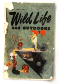
magazine, Wild Life, April 1953
This magazine promotes the protection of wildlife and the need for proper management of national parks. Its editor Crosbie Morrison lobbied for a National Parks Authority which was finally set up under Morrison's directorship in 1957. During the 1940's and 1950's Crosbie Morrison (1900 - 1958) became Australia's best known naturalist. As a journalist with commercial radio and the Australian Broadcasting Commission, he made regular national nature study broadcasts to schools and other radio listeners for 20 years. He was the editor of Wild Life, a magazine which fostered interest in Australia's natural history and conservation, from 1938-54. (ref. CHAH web-site) This magazine reflects the work and legacy of Crosbie Morrison who campaigned for Victoria's national park system.A 398 pp soft covered magazine with green covers. The title "WILD LIFE and OUTDOORS" is in black print.Below this is a coloured drawing of two women camping on the edge of a cliff. One is hanging on to the edge looking at a bird's nest. The magazine contains articles and photographs in black / white print.on front cover - "M. Gilbert' in red penmagazine-wild-life morrison-crosbie natural-history natural-science -
 Orbost & District Historical Society
map/brochure, Discovering Marlo & The Snowy River Estuary, December 1988
In 1983 the Department of Conservation, Forests and Lands replaced the Department of Crown Lands and Survey, the Department of State Forests and the Ministry for Conservation. This brochure/map was used as tourist information in Orbost.This item is a useful research tool.A folded map/brochure titled "DISCOVERING MARLO & THE SNOWY RIVER ESTUARY". On the front is a photograph of Marlo and the title in yellow print. There is a locality map for access to Corringle beach and the brochure Includes a key to fishing sites and various tourist locations. On the back of the brochure are notes on fishing, wildlife and a boating guide, map brochure snowy-river marlo -
 Mission to Seafarers Victoria
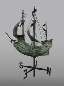
Decorative object - Finial, c. 1920
Appearances to the contrary, the item is not a weathervane but a finial. It was the gift of Mr John Sanderson (Jottings Easter 1920), from John Sanderson & Co., wool merchants, stock and station agents, commission and shipping agents before he leaves for England to become senior partner in Sanderson Murray & Elder, London, import and export agents. It was designed by Walter & Richard Butler Architects. (sketch published in Building : the magazine for the architect, builder, property owner and merchant vol.33, no 193, 12 Sept. 1923). The finial was already drawn on the sketch of the Central Institute made by Walter Butler. The maker of the finial, was Henry Alfred George Arnold Saw (born June 1881 in Hotham, Victoria was the son of Edward Saw (1854-1926) a tinsmith and Catherine Barton (1863-1907). He worked as a metal artificer for a metal-working business located opposite the Trades Hall in Lygon Street and was given the job of making the copper ship finial. Henry married Florence Charlotte Reeder and they had four children. Also known as Harry Saw according to his grandson Brian, he died on 9th February 1960. Henry and Florence both died within two months of each other in 1960. It is not clear when the ship was actually installed on the roof, the earliest photograph dating from 1927. The windvane fell or moved several times because of gale forces: - In 1995 : After the funds were raised to repair it, it was treated by sculptor David Hope, and reinstalled in the 1998 (Ship to Shore #3 Sept 1998). - In 2017: Carmela Lonetti from the Grimwade Centre for Cultural Materials Conservation (Ship to Shore Autumn 2017) - In 2019: a generous passerby donated the necessary funds for the conservation. It was sent to Grimwade Centre for Cultural Materials Conservation (Ship to Shore 2019), treated by Evan Tindal (City of Melbourne Magainze Oct. 2020). It was reinstalled over the Summer of 2019-2020 (Ship to Shore Summer 2020). The weathervane was stolen during the night of the 6-7 March 2022. Copper price surge sparks rise in theft in Victoria in 2021-22 so it's likely the vane was stolen to be melted This sculpture is closely associated with the 1917 building and described in clippings and annual reports when the building was first newly opened. It can be seen in some of the earliest photographs of the new building and in the artist/architect Butler's impressions. The galleon is often a decorative design of Mission to Seafarers wind vane (London, Adelaide).Bronze and copper sculpture fashioned as a Wind Vane in the form of a Galleon style sailing ship with 2 pennants flying and two sails rigged atop with lower cross piece with wind directions N S E W . There is a decorative ornamental pierced scrollwork ferrule / finial with reinforcing chrome steel piping armature at base of main support which attaches to the roof or a base support. See also comments below weather vane, wind vane, sculpture, galleon, sailing ship, finial, henry alfred saw, david hope, windvane, weathervane, walter richmond butler (1864–1949), richard butler, john sanderson -
 Warrnambool and District Historical Society Inc.
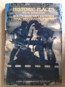
Book, Historic Places of South West Victoria
This is the third in a series of booklets produced by the Land Conservation Council in 1997 (176 pages). Booklets One and Two (1996) contained A Descriptive Report and Proposed Recommendations. The Final Recommendations include information on processes for protection of historic places, lists of significant places in the south-western region and aboriginal historic places. Attached inside the back cover are two maps showing the location of the significant places.This is a useful book as it lists the declared historic sites in the region and researchers will find the information helpful. This is a soft-cover book with a multi-coloured cover featuring a photograph of the Pioneers Memorial, Deep Lead. It has a red-coloured spine and back cover.Front Cover – Historic Places - Special Investigation - South-Western Victoria - Final Recommendations – Land Conservation Council Spine – Historic Places – South-Western Victoria – Final Recommendations – Land Conservation Council Back Cover – Historic Places, Final Rec., code used for retail sales warrnambool -
 Warrnambool and District Historical Society Inc.
Document, HeritageWorks Personnel, Warrnambool Pioneers Board, 2017
This is an invitation to the launch of the conservation and publication project for the Warrnambool Pioneer Honour Board. The invitation was sent out in the name of Lilian Foyle, the Warrnambool photographer and artist who produced the portraits and some of the sketches on the board. A person representing Lilian Foyle welcomed those who came to the launch. The Pioneer Honour Board, initiated by Edward Vidler, was first assembled in 1907 to mark the 60th anniversary of the founding of Warrnambool. It has the portraits of 204 pioneer men of Warrnambool and district and is one of the best examples of a pioneer honour board in Victoria. It now requires extensive conservation work and an appeal has been launched to cover the cost of this. A publication with biographies of the 204 men is also being prepared. This invitation is of great interest as it is connected to the Warrnambool Pioneer Honour Board which is one of the most important historical items in the city of Warrnambool and a work of art in its own right.This is a buff-coloured piece of paper with black printing and a black and white photograph of Lilian Foyle. There are also two ornamental patterns on two corners of the printing. ‘Lilian Foyle, photographer and artist, invites you to meet the men on the Warrnambool Pioneers Board at the launch of the conservation & publication project to be held at HeritageWorks on Sunday 17 September at 2.30 pm’warrnambool pioneer honour board, lilian foyle, edward vidler -
 Eltham District Historical Society Inc
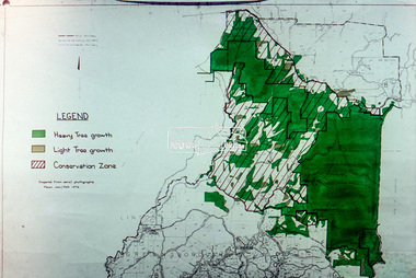
Slide - Photograph, Eltham Shire Council, Kinglake Conservation Zone and Tree Growth, Melbourne Metropolitan Planning Scheme, Amendment No. 21, Melbourne and Metropolitan Board of Works, Apr 1972
35mm colour positive transparency blue Agfacolour Service plastic mountmap, melbourne metropolitan board of works, mmbw, planning proposals, shire of eltham, planning -
 Glen Eira Historical Society
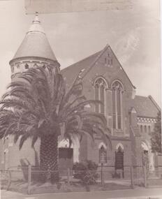
Document - St. Mary’s Church, Caulfield
Photocopied copy of Andrew Ward’s February 1994 conservation study he completed of St. Mary’s Church. Includes exterior and interior photograph. Two information leaflets on St. Mary’s Church of England and St. Mary’s Jubilee School, giving brief history of the church and hall. Includes sketches of church features.glen eira road, st. mary’s church, gothic architecture, bluestone, towers, bell, reed and barnes, stephen george sir, helenslea, jubilee school, schools, stained glass, bell towers, arches, roofs, bonham james, perry bishop, little and byrne, peck arthur, hood crescent, ward andrew, building construction, reid and barnes, cockram and co., moorehouse bishop, webb charles, goe bishop, shelford girls grammar school, architectural features, porches, bishops -
Glen Eira Historical Society
Letter - St. Stephen’s Presbyterian Church, Caulfield
Two documents regarding the historical significance of St. Stephen’s Church, 158 Balaclava Road Caulfield. The first document is correspondence dated 25/09/1990 from the National Trust informing the City of Caulfield of the inclusion of the church on the National Trust Register. The second document is a photocopy of the Caulfield Conservation Study by Andrew Ward dated February 1994. It includes an unclear front view photograph, references and recommends planning scheme control.city of caulfield, caulfield, caulfield north, balaclava road, kooyong road, st. stephen’s church, presbyterian church, uniting church, ward andrew, kinross george, currie george, haddon robert, architects, builders, churches, caulfield conservation study, national trust register, gothic revival architecture, architectural features, architectural styles, heritage studies, patios, windows, registers, symbols, fundraising events, religious ceremonies, religious groups -
 Glen Eira Historical Society
Article - Boyd Park
This file contains two items. Two original photographs of Boyd Park, date unknown. An article from the CAULFIELD/ PORT PHILLIP LEADER on a massive swamp gum tree that was felled by heavy winds in Boyd Park, Murrumbeena, dated 03/08/2012.glen eira, glen eira environment group, smith colin, caine paul, boyd park, murrumbeena, parks, conservation of natural land and energy economics, reserves, bushland, gardens, resources, trees, plants -
Glen Eira Historical Society
Document - PRENTICE STREET, 59, ELSTERNWICK
Two items about this property: 1/Caulfield Conservation study by Andrew Ward, dated September 1994. His description of the villa is brief, he includes a small history of the street and ownership/tenants from 1885 to 1924. 2/Newspaper advertisement on newly built Elyse at 59 Prentice Street, Elsternwick. Details modern features of home and the incorporation of Edwardian style as well. Dated 16/03/2002 and includes 2 coloured interior and 1 colour exterior photographs.prentice street, victorian style, fitzmonnie leonora, ward andrew, elsternwick, timber houses, manson emmert, bricklayers, buxtons, corrugated iron, kooyong road, tiles, 'elyse', edwardian style, estate agents, verandah, fitzmonnie henry, newsagents, lowe s andrew, architectural features, fitzmonnie john, elliott william, elliott marc -
Glen Eira Historical Society
Document - Myatt
Photocopied pages of Andrew Ward’s Caulfield Conservation Study, dated February 1994, giving descriptions and brief history of home and owner/occupant in 1906. Includes significance of Myatt’s decorative timberwork and architectural traditions of the Edwardian period. Includes a black and white photocopied photograph of the exterior.caulfield conservation study, architectural features, mayfield grove, williams henry, myatt, ward andrew, housename, timber houses, edwardian style, caulfield north -
Glen Eira Historical Society
Document - Roseneath, Nepean Highway, 31, Elsternwick
A photocopy of a Caulfield Conservation Study conducted in January 1995 by historian Andrew Ward of the house Roseneath named thus by 1904. The document includes a photocopied photograph of the front façade, although the features are unclear. The document, which includes a bibliography, details the history of Roseneath, including owners and occupiers, as well as the architectural features of significance and historical value.ward andrew, millar william, boyle andrew, worthington george, tulloch annie, cross anastasia, meek alex, caulfield, roseneath, elsternwick, nepean highway, mcmillan street, point nepean road, rusden street, cumbernauld, hawthorn road, glenmoore, st. georges road, caulfield south, shire of caulfield, east st. kilda riding, historic buildings register, national trust register, national estate register, italianate style, architectural styles, architectural features, mansions, brick houses, verandahs, cast iron work, bluestone, bay windows, land subdivisions, merchants, judges, leases, councillors -
Glen Eira Historical Society
Document - ‘KENLY’, Gladstone Parade, 34, Elsternwick
This file contains two items about this property: 1/Photocopy of Caulfield conservation study on ‘Kenly’ (1899) completed by Andrew Ward in October 1994. Includes a brief history of owners and tenants from 1888 to 1941 and a description of its architectural features as well as a black and white exterior photograph. 2/Two colour exterior photographs dated 13/10/2011gladstone parade, elsternwick, ‘kenly’, house names, 21-aug-18, mansions, hume c., kooyong park estate, clarence street, jackson thomas b., shoobra road, wells andrew, ford grylls, langwill p., henriques fred, pearson alfred, edmends james, williamson alfred, caulfield, ward andrew, architectural styles, victorian style, verandahs, brick houses, windows -
Glen Eira Historical Society
Document - Tudor Court, Kooyong Road, 141, Caulfield North
Photocopy of a conservation study of Tudor Court by Andrew Ward dated January 1995. Includes description of architectural features, brief history and photograph of exterior of the house.caulfield, kooyong road, tudor court, knowsley, airdrie, holt frederick, ward andrew, holt annie, hope george, duffield lancelot, rippin john, mansions, architectural features, federation style, towers, chimneys, stairs, glen eira road, balaclava road, fairholme, fairhaven -
 Glen Eira Historical Society
Letter - Carnegie Methodist Church, Neerim Rd, 252- 254, Carnegie
Caulfield Conservation Study – Andrew Ward 1995 with photos. Photocopy of extract from the study. Two Black and White photographs of the Carnegie Methodist Church 1) 90mm x 135mm 2) 80mm x 115mm. Sats unknown. Handwritten research note on the Carnegie Methodist Church. Undated and unacknowledged. Letter, National Trust of Australia (Victoria) notifying inclusion of the Carnegie Methodist on the Register – 25/09/1990carnegie, rosstown state school, rosstown, neerim road, carnegie state school, coles a. phipps, schools, oakleigh circuit, ward andrew, toolambool road, methodist circuit, carnegie methodist church, broadbent l. c., snell j. f., reid g., rosstown theatrical company, methodist church, uniting church, architectural styles, architectural features, frederick h. w. rev., californian bungalow, sunday schools, towers. -
Glen Eira Historical Society
Document - Brighton Cemetery, North Road, Caulfield South
Photocopy of the entry in the Caulfield Conservation Study by Andrew Ward dated 01/1995, for the Brighton Cemetery, former sexton’s quarters and offices. The study includes a description of the architectural features and a brief history of the building and two photographs of the building exterior.brighton cemetery, north road, ward andrew, cemeteries, graveyards, brighton cemetery trust, architectural styles, architectural features, roofs, brick houses, official buildings, caulfield south -
Glen Eira Historical Society
Document - Brighton Cemetery, North Road, Caulfield South
Photocopy of the entry in the Caulfield Conservation Study, dated 01/1995, by Andrew Ward for the Miller Mausoleum at Brighton Cemetery. The study includes a description of the tomb’s architectural features, a brief history and a photograph of the tomb.miller mausoleum, brighton cemetery, caulfield south, north road, ward andrew, miller septimus, miller clara johnstone, miller gwendoline stewart, cantala, dandenong road, cemeteries, graves, tombstones, gravestones, monuments and memorials, architectural styles, gothic (revival) architecture, architectural features, gables, roofs, windows -
 Glen Eira Historical Society
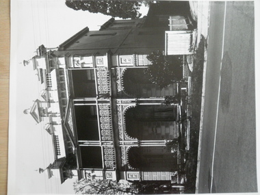
Document - Elsternwick Congregational Church – Caulfield Union Church
Photocopy of extract of Caulfield Conservation Study by Andrew Ward dated September 1994. Includes brief history and description of Elsternwick Congregational Church and black and white exterior photograph and references. Printed page, dated and source unknown, with sketch of the church and a brief history. Five colour, one black and white exterior, photographs date and photographer unknown.elsternwick congregational church, caulfield union church, orrong road, architectural features, architectural styles, gothic revival architecture, elsternwick, towers, korong street, glen eira road, king street, de lacy evans g., mcmurtie mcnaughton and stewart, copland osric rev., uniting church, congregational church, corrong street, religious structures and establishments -
Glen Eira Historical Society
Letter - St Aloysius Church, Caulfield
A series of correspondence dated between 21/08/1985 to 10/11/1988 regarding the Historic Buildings Council adding St Aloysius Church on Balaclava Road, Caulfield to the Historic Buildings Register. Four of the letters are between the Historic Buildings Council, the Caulfield Historical Society and the City of Caulfield. Copies of the replies by the Historical society (as indicated by handwritten notes in the letters) are not included in the file. A fifth letter dated 14/09/1989, addressed to Reverend Father John Fraser, Parish Priest at St Aloysius, advises him of the inclusion of St Aloysius on the National Trust Register due to its historic significance. Also included is a photocopy of the Caulfield Conservation study of St Aloysius, dated February 1994, by Andrew Ward. This study details the architectural features and historic significance of the church, recommending planning scheme control. It includes a front view photograph, which is not clear, and references.caulfield, catherine street, tonkin ray, st aloysius church, grey karen, fraser john rev. fr., catholic church, wills cathie, davies stephen, balaclava road, ballantyne r mr, ward andrew, city of caulfield, head stephen, moriarty bartholemew, de carle henry, mannix archbishop, caulfield historical society, caulfield conservation study, foundation stones, town halls, local officials and employees, registers, committees and inquiries, gothie (revival) architecture, architectural features. -
Glen Eira Historical Society
Document - Grace Darling, Bond Street, 1, Caulfield North
A photocopy of a four page extract of a Caulfield Conservation Study by Andrew Ward, dated 08/1994, on the house Grace Darling, located at 1 Bond Street, Caulfield North. The study describes the house and its stables, including architectural features, and provides a history of the property owners and a statement of the house’s historical significance to Caulfield and horse racing. The study includes a photograph of the house exterior (100mm x 150mm), a photograph (100mm x 150mm) of the stables exterior and a photograph (130mm x 100mm) of the interior of the stables.grace darling, bond street, caulfield conservation study, ward andrew, architectural features, architectural styles, victorian style, williams john, balaclava road, reid j g, duffet j, caulfield cup, caulfield north, victorian amateur turf club, booran road, reddan road, melbourne cup, historical buildings register, national estate register, national trust register, horse racing, race horses, race horse trainers, jockeys, stables, loose boxes, timber houses, roofs, cast iron work, lofts, bricks -
Glen Eira Historical Society
Document - Gunyah, Kooyong Road, 283, Elsternwick
A two page photocopy of a Caulfield Conservation Study by Andrew Ward, dated 09/1994, on the house Gunyah located at 283 Kooyong Road, Elsternwick. The study includes a brief history of the property, a description of the house’s architectural features, a statement of its significance and a photograph (100mm x 150mm) of the house exterior.gunyah, kooyong road, elsternwick, ward andrew, caulfield conservation study, elsternwick, caulfield, rothesay, italianate style, architectural styles, ricketson henry, prentice street, mount l l, morrison alan, cummins alfred, cumberland rose, mansions, villas, glen eira estate, calista court, hendra court, architectural features, city of caulfield -
Glen Eira Historical Society
Document - Hartington
A two page photocopy of a Caulfield Conservation Study by Andrew Ward, dated 10/1994, on the house Hartington at 15 Gladstone Parade. The study gives a description of the architectural features of the house, a brief history of the house and includes a photograph (100mm x 153mm) of the exterior of the house.kooyong park estate, hartington, burnett templeton captain, kirkham charles f, gladstone parade, clarence street, victorian style, hartington street, justices of the peace, ward andrew, land subdivisions, architectural styles, architectural features, windows, elsternwick, caulfield conservation study -
Glen Eira Historical Society
Document - Heatherbrae
A three page photocopy from a Caulfield Conservation Study by Andrew Ward, on house Heatherbrae located at 73 Neerim Road. The study gives a brief history of the property, describes the house’s architectural features and heritage significance and includes a photograph (100mm x 152mm) of the exterior of the house. The file also includes a page of undated, unattributed, handwritten notes giving a partial list of Heatherbrae’s occupants from 1885 to 1900s and some description of the house. Also included in the file is an undated, unattributed one page handwritten list of the main occupants of Heatherbrae between 1880 and 1970. The file also includes one page of research notes by Dianne Visnovsky, dated 06/11/2009, with details of a publication that describes church fairs held at Heathrbrae circa 1910. These notes are accompanied by a handwritten annotation by Claire Barton dated 05/03/2012.heatherbrae, mansions, neerim road, caulfield conservation study, architectural features, architectural styles, holland john charles, booran road, glenhuntly road, kambrook roads, griffiths george f, vail e l junior, clarke alfred e, clarke margaret h, mcgowan beatrice, mcgowan leslie, macgowan leslie, buildings, caulfield, heatherbrae avenue, clarke street, stoddart j, ross william murray, wright william t, macgowan m h, mcgowan malcom, mcgowan jean, barton claire, visnovsky dianne -
Glen Eira Historical Society
Document - Hengar, Glen Eira Road, 356, Elsternwick
A photocopy of a two page Caulfield Conservation Study by Andrew Ward, dated 01/1995, on Hengar at 356 Glen Eira Road, Elsternwick. The study gives a brief history of Hengar’s construction and occupancy, a description of its Gothic revival architectural features and a statement of its heritage significance. The study includes a black and white photograph of the exterior of Hengar.langdon henry, renwick mary, langdon elizabeth, langdon laura, blanche street, glen eira road, kooyong road, langdon estate, elsternwick, caulfield, hengar, beemery park, rosecraddock, tarqua, beemery, happy days kindergarten, architectural styles, architectural features, gothic revival, victorian style, preschools, the contemporary school of art -
Glen Eira Historical Society
Document - Hopetoun, Hopetoun Street, 2, Elsternwick
Photocopy of Caulfield Conservation Study for this address, conducted in September 1994. It outlines a description of the Italianate villa architectural aspects of Hopetoun Private Hospital, the history of the owners of the property and the recommendations for inclusion on the National Estate Register and for the planning Scheme control. By Andrew Ward. Includes two photocopied photographs of the exterior of the exterior.italianate style, hopetoun, melrose, hospitals, verandahs, mansions, towers, architectural features, architectural styles, webb charles, architects, glenhuntly road, elsternwick, cutts joseph, korong street, king street, hopetoun street, geoghegan hanbury, webb alfred, kopat pty ltd, webb florence mabel, o’brien annie, reeve charles, haines edith, thomas albert, ward andrew, hopetoun private hospital -
 Glen Eira Historical Society
Document - Kahlyn, 70 Bambra Road, Caulfield North
A three page black and white photocopy of a Caulfield Conservation Study of Kahyln House, formerly Kynaston, 70 Bambra Road, Caulfield North, by Andrew Ward in August 1994. The report describes key architectural features of Kahlyn House and gives a brief history of the property’s ownership. The study includes a photograph of the exterior of Kahlyn. The file also includes an undated, unattributed colour photograph (100mm x 150mm) of the exterior of Kahlyn. An undated, unattributed black & white photograph digital version only.danphy catherine, anderson grace, beauchamp horatio, murray reginald, murray kynaston l, holst frederick, ward andrew, hudson street, caulfield, caulfield north, bambra road, kahlyn private hospital, mansions, hospitals, houses, architectural styles, towers, victorian style, verandahs, kahyln, kynaston -
 Glen Eira Historical Society
Letter - Lisbon House
Copy of a notification letter from National Trust of Australia to the owner Mrs EM Reeves that Lisbon House been classified. Dated 26/03/1994 Photocopy of conservation study of Lisbon House by Andrew Ward in October 1994. Includes brief description and history and photograph of the house. Letter from the Historic Buildings Council to owners of the Lisbon House advising on the application to review and include the house in the Historic Buildings Register. Letter dating 31/03/1995. Letter dated 18/09/1995 from the HBC to the owners of the house advising them that the house will not be added to the register. One page description of Lisbon House with sketch of facade. Date and source unknown. Photograph of Lisbon House. Date unknown, black and white, photographer unknown.reeves e m, hart t, ward andrew, brown mary, brown walter, weigall reginald, brown em, mould arthur, symons george, read m, tonkin ray, kons a&a, caulfield, elsternwick, orrong road, lisbon house, glenhuntly road, city of glen eira, verandahs, cast iron work, architectural styles, italianate style, victorian style, caulfield historical society, caulfield north