Showing 63 items
matching coolstores
-
 Ringwood and District Historical Society
Administrative record - Minutes, Ringwood Cool Stores Co-operative Society Ltd - Minutes Book-Minutes 1954-1955
... Coolstores ...Scanned copy of Minutes of the Ringwood Cool Stores Co-operative Society Ltd for the years specified. The originals are in the large Kalamazoo Binder referred to in VC Record 11220. coolstores -
Ringwood and District Historical Society
Administrative record - Minutes, Ringwood Cool Stores Co-operative Society Ltd - Minutes Book-Minutes 1948-1949
... Coolstores ...Scanned copy of Minutes of the Ringwood Cool Stores Co-operative Society Ltd for the years specified. The originals are in the large Kalamazoo Binder referred to in VC Record 11220. coolstores -
Ringwood and District Historical Society
Administrative record - Minutes, Ringwood Cool Stores Co-operative Society Ltd - Minutes Book-Minutes 1952-1953
... Coolstores ...Scanned copy of Minutes of the Ringwood Cool Stores Co-operative Society Ltd for the years specified. The originals are in the large Kalamazoo Binder referred to in VC Record 11220. coolstores -
Ringwood and District Historical Society
Administrative record - Minutes, Ringwood Cool Stores Co-operative Society Ltd - Minutes Book-Minutes 1956-1957
... Coolstores ...Scanned copy of Minutes of the Ringwood Cool Stores Co-operative Society Ltd for the years specified. The originals are in the large Kalamazoo Binder referred to in VC Record 11220. coolstores -
Ringwood and District Historical Society
Booklet - Auction Catalogue, Ringwood Cool Stores Co-operative Society Ltd - Auction Sale-Machinery and Plant, Buildings for Removal. 2nd December 1959
... Coolstores ...A5 Buff coloured Auction Catalogue for the aucrion of 177 items. Important Auction Sale Wednesday December 2nd 1959 at 11am, on the premises 108 Whitehorse Road, Ringwood (Corner Wantirna Road) Cool Stores Machinery and Plant Building for Removal To the Order of the Ringwood Co-operatie Cool Stores owing to expiration of the Lease. --- On View Tuesday December 1st - 9:30am - 4 pm --------------------- Auctioneers E. M. Purdy & Co. Pty Ltd. 20 Queen Street Melbourne. 61-2141 (3 Lines)coolstores -
Ringwood and District Historical Society
Administrative record - Minutes, Ringwood Cool Stores Co-operative Society Ltd - Minutes Book-Minutes 1960 including windup of the Society
... Coolstores ...Scanned copy of Minutes of the Ringwood Cool Stores Co-operative Society Ltd for the years specified. The originals are in the large Kalamazoo Binder referred to in VC Record 11220. This appears to be the final minutes prior to winding up of the Society, however the Minutes do state that the Committee will continue. No further minutes have been located as of 16/6/2025. coolstores -
Ringwood and District Historical Society
Administrative record - Minutes, Ringwood Cool Stores Co-operative Society Ltd - Minutes Book-Minutes 1950-1951
... Coolstores ...Scanned copy of Minutes of the Ringwood Cool Stores Co-operative Society Ltd for the years specified. The originals are in the large Kalamazoo Binder referred to in VC Record 11220. coolstores -
Ringwood and District Historical Society
Administrative record - Minutes, Ringwood Cool Stores Co-operative Society Ltd - Minutes Book-Minutes 1958-1959
... Coolstores ...Scanned copy of Minutes of the Ringwood Cool Stores Co-operative Society Ltd for the years specified. The originals are in the large Kalamazoo Binder referred to in VC Record 11220. coolstores -
 Whitehorse Historical Society Inc.
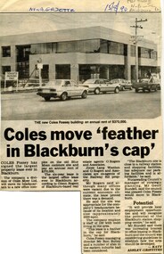
Article, Coles move 'feather in Blackburn's cap', 1990
Coles Fossey (Coles Myer Ltd) to lease new office complex on old Blue Moon coolstore site. The largest office lease ever in Blackburn.Coles Fossey (Coles Myer Ltd) to lease new office complex on old Blue Moon coolstore site. The largest office lease ever in Blackburn.Coles Fossey (Coles Myer Ltd) to lease new office complex on old Blue Moon coolstore site. The largest office lease ever in Blackburn.coles myer ltd, railway road, blackburn, blue moon fruit co-operative ltd -
 Ringwood and District Historical Society
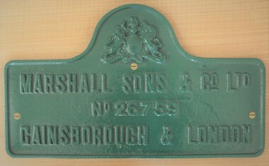
Plaque - Cast iron machine badge, Engine maker's plate from former Ringwood Coolstore (1911 - demolished 1963)
Green cast iron engine plaque featuring maker's name mounted on varnished timber backing, retrieved by Ron Pullin for preservation by Ringwood Historical Society following demolition of Ringwood Coolstore in 1963.Marshall Sons & Co Ltd No 26759 Gainsborough & London -
 Ringwood and District Historical Society
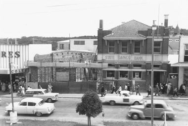
Photograph, Maroondah Highway Central, Ringwood. State Savings Bank extension, 1963
Black and white photographWritten on rear of backing sheet: "Extension of bank. Photo taken from roof of coolstore, 1963". -
 Ringwood and District Historical Society
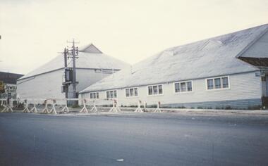
Photograph, Ringwood Cool Store, cnr Maroondah Hwy and Wantirna Road, - Dec, 1959
Coloured photographWritten on back of photograph: "The coolstore, corner Whitehorse and Wantirna Roads, Ringwood. 6/12/59". -
 Ringwood and District Historical Society
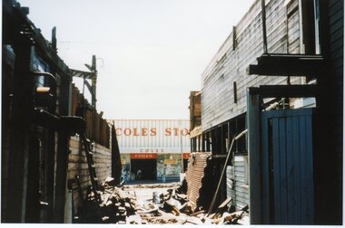
Photograph, Coles Store - Ringwood - circa 1960's
Postcard size colour photograph'Written on back of photograph" Coles Store, Maroondah Highway, looking through Coolstores demolition -circa 1960's -
 Whitehorse Historical Society Inc.
Photograph - Black and white strip and photocopy, Blue Moon Cool Stores, 1/08/1976 12:00:00 AM
... Coolstores ...B/W strip photo of Blue Moon Cool Stores, Blackburn.blue moon fruit co-operative ltd, coolstores, blackburn -
 Whitehorse Historical Society Inc.
Photograph - Black and white strip and photocopy, Blue Moon Cool Stores, 1/08/1976 12:00:00 AM
... Coolstores ...B/W strip photo of Blue Moon Cool Stores, Blackburn.blue moon fruit co-operative ltd, coolstores, blackburn -
 Ringwood and District Historical Society
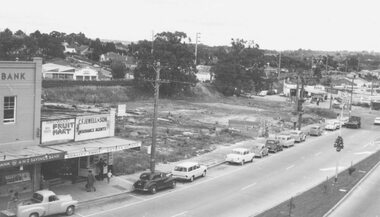
Photograph, Ringwood Coolstore site after clearing, 1962
Black and white photograph (2 copies)Image taken from Town Hall roof and shows cleared site of coolstore on corner of Maroondah Highway and Wantirna Road. -
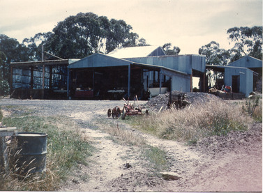 Southern Sherbrooke Historical Society Inc.
Photograph - Photo-colour- vehicle shed and first coolstore
Colour photograph of various vehicles in corrugated iron shedding at Narre Warren orchard. A barrel drum can be seen in the extreme left side of frame. The driveway heading to the sheds has a plough-like device resting there. The section to the left is the first coolstore built on the property. -
 Ringwood and District Historical Society
Historical Notes, Historical Notes for Doncaster, Templestowe, Croydon, Ringwood, Nunawading (undated) - Ringwood Historical Research Group, 2-Nov-68
Programme of exploration of interesting historical buildings etc. in Ringwood, Croydon and Doncaster Templestowe areas including Doncaster Inn Hotel Schramm's Cottage, Wicklow hills, Croydon, Coolstore, Clocktower and Town hall in Ringwood and Schwerkolt's Cottage Nunawading. Programme of the tour by people from Mornington on 2-Nov-1968Historical notes 7 pages of notes convened by Ringwood Hist. Research Group in conjunction with Croydon. Nunawading and Doncaster Templestowe Hist. Societies +Additional Keywords: Pullin,R.A. / McGivern, M / Field, J. (Mrs.) / Greene,I -
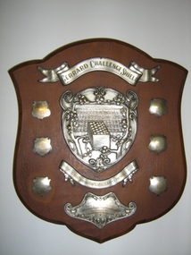 Harcourt Valley Heritage & Tourist Centre
Gerrard Challenge Shield, Apple Packing Competion, 1934
State school children in the famous orchard district of Harcourt were expected to learn apple packing to a high standard, with instruction given by Dept of Agriculture specialist teachers, Classes were conducted at Harcourt Cooperative Coolstores during school hours.The pupils were expected to (and did) travel between school and packing shed by their own means without supervision..Pupils participated in state wide competitions .Shows the extent to which vocational training in a specialized subject could be taken to support the Apple Industry of Harcourt. The decoration/artwork of the shield is to a very high standard A wooden shield with metal adornments. A banner is at the top with "Gerrard Challenge Shield", a central metal shield shaped plaque shows a box of apples surrounded by trees and many boxed apples in the background. Below that is a banner with " District Championship for Schools Apple Packing Classes. Below that (at the bottom) is a smaller plaque with "Competitors to be pupils & attending school children's Apple Packing Classes." "Conducted by the Department of Agriculture." On the left side are three smaller shields for the years 1934 to 1936 awarded to Castlemaine the three shields on the right are blank. -
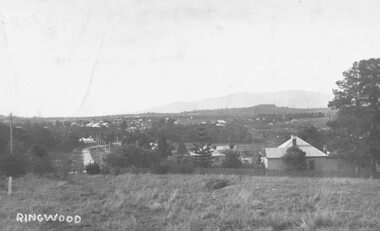 Ringwood and District Historical Society
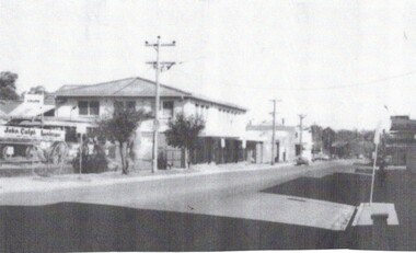
Photograph, View over Ringwood from Heatherdale Road
Black and white photograph (2 copies)Typed below photograph: "View over Ringwood from Heatherdale Road. Note Maroondah Highway on left and Coach and Horses Hotel at end near bend and coolstores beyond that c1930." -
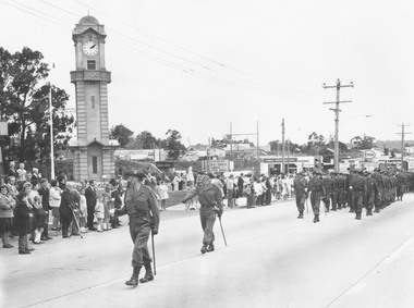 Ringwood and District Historical Society
Photograph, Ringwood Clocktower re-opening ceremony, Cnr Maroondah Hwy and Wantirna Road, Ringwood - December 1967
Black and white photographTyped below photograph: "Re-dedication of Clocktower Memorial when placed in present site (site previously coolstore)." Plaque was unveiled by local resident Major-General L.E. Beavis. -
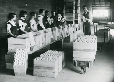 Ringwood and District Historical Society
Photograph, Apple packing class, Mr Krone instructor. Ringwood c1926
Black and white photograph"Written on back of photograph" Apple packing class - Mr Krone instructor. Marybell McAlpin on left. "Attached to back of photograph" Packing class at Ringwood Coolstores -children from Ringwood State School No2997 (Probably children of orchardists) Teacher provided by Agriculture Department. -
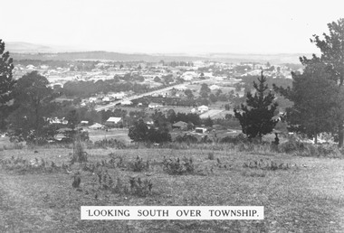 Ringwood and District Historical Society
Photograph, Looking south over Ringwood township from Loughnans Hill c1930. Ringwood Street is the main road in the centre
Black and white photograph taken from hill overlooking township of Ringwood. (3 copies)Printed on photograph, "Looking south over township". Typed below photograph, "View from Loughnans Hill c1930. Ringwood Street is the main road in the centre. Old St. Pauls, railway crossing, Methodist church, state school, coolstores, etc. can all be seen". -
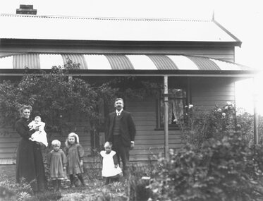 Ringwood and District Historical Society
Photograph, Herman and Louisa Pump and family (Wilfred, Alma, Linda, Ella and Rita) outside family home on Canterbury Road, c.1914. Later became site of Heathmont Uniting Church
Written on backing sheet, "Herman Pump and family ". Mr. Herman Pump and family outside family home on Canterbury Rd. Now site of Uniting Church.Black and white photograph of family standing outside a house. "Herman Pump's family. Orchard rear of house (Herman was Sec. of Coolstore at one time)." -
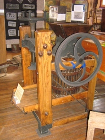 Harcourt Valley Heritage & Tourist Centre
Cider Press, 1880s
A 'BUCKEYE" grape and cider press, manufactured by P.P. Mast & Co. of Springfield, Ohio, USA and distributed by P. Rohs, Sandhurst (Bendigo). The PP Mast Company was established in 1854. Their Buckeye drills, seeders and other implements played an important role in the development of American farm machinery, being sold in every American state, Europe and Australia. This press was used by the Gaasch family of Harcourt over several generations from 1898 to crush grapes for wine and vinegar making, subsequently to crush apples and then press the pulp to make apple vinegar and cider. The crushing was accompanied by lusty singing of songs and hymns such as 'Ein Feste Burg ist unter Gott'. The press was designed to be hand-operated but was later used by Harcourt Coolstores to press apples. It was then belt-driven by an electric motor. The press was restored (timber cleaned and varnished, metal shoes on base of wooden uprights, which had rotted ) by Mr. Howard Carr, 2001-An early application of mechanics to the crushing of grapes. Hand-driven, geared drive metal crushing parts, with metal flywheel, wooden feed hopper in vertical arrangement, wooden frame, tray and vat, with metal pressing screw installed in heavy metal yoke at front. Metal crushing section carries cast-in maker's name and patent details'BUCKEYE" manufactured by P.P. Mast & Co. of Springfield, Ohio, USA distributed by P. Rohs, Sandhurst (Bendigo). -
 Ringwood and District Historical Society
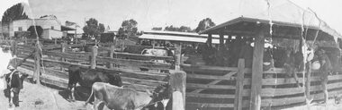
Photograph, Ringwood Market and Saleyards 1914
Black and white photograph (3 copies including original copy in poor condition)Typed below one photograph: "Ringwood Market and Saleyards. Now the site of the new Ringwood Market. Taken from Charter St. looking south east towards corner of Ringwood St. and Maroondah Highway. Old Coolstores in background on left were on Wantirna Rd. - 1914". Typed below another copy: "Ringwood Market - Corner Ringwood St. and Main St. - 1914". -
 Ringwood and District Historical Society
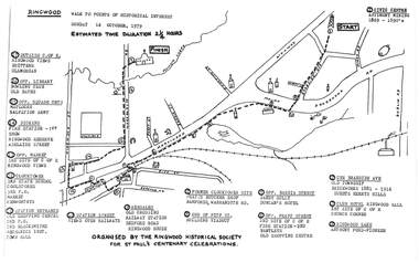
Pamphlet, Ringwood Walk - Points of Historical Interest, 1979
Sketch of walking route for 17 historical points of interest organised by the Ringwood Historical Society for St. Paul's Church Centenary Celebrations - 14 October 1979, estimated duration 2-1/4hours.1 - Start 2 - Cnr Braeside Avenue, old township, brickworks 1881-1916, Guests, Herrys, Hills 3 - Club Hotel, Ringwood Hall, 1st site of C of E church corner 4 - Ringwood Lake, Anthony Ford - pioneer 5 - Opposite Bardia Street, Sandy Gully, Duncan's Hotel 6 - Opposite Pratt Street, 2nd site of C of E, 2nd fire station, Bentleys, old shopping centre 7 - Warrandyte Road, Former Clocktower site, Pratts butcher shop, Bamfords 8 - End of Pitt Street, building viaduct 9 - Bedford Road, Webdales, old crossing, railway station 10 - Station Street, views over railways 11 - Station entrance, old shopping centre, 2nd Postoffice, 2nd blacksmiths, Mechanics Institute, Town Hall 12 - Clocktower, 3rd State School, coolstores, 3rd Postoffice, market, Kenworthys 13 - Opposite market, 3rd site of C of E, Ringwood views 14 - Adelaide Street, Dickens, 1st fire station, Ringwood Reserve 15 - Opposite squash courts, Matlocks, Salvation Army 16 - Opposite library, bowling club, old baths 17 - Outside C of E, Ringwood views, Brittens, Glamorgan -
 Eltham District Historical Society Inc
Photograph - Digital Photograph, Marguerite Marshall, Strathewen Public Hall, 20 August 2008
Strathewen Public Hall, social and spiritual centre was later lost in the Black Saturday fires 2009. The Strathewen Community decided a community hall was needed in 1901. In 1902 locals built the hall with messmate trees. It was located on the Cottlesbridge-Strathewen Road. The first function was a Grand concert and Balll attended by about 120 people. Several denominations held Church services and Sunday School services in the Hall. It survived several bushfires until after this photo was taken when it was destroyed in Black Saturday, 9 February 2009. Published: Nillumbik Now and Then / Marguerite Marshall 2008; photographs Alan King with Marguerite Marshall.; p89 Strathewen was settled late, largely because it was difficult to access.1 Early selectors found it a struggle to survive. They had to do everything themselves, from felling trees for buildings, to taking produce to market along bush tracks that they had helped cut. Small dairy farms were typical but fruit became the district’s prime produce. The first settlers east of Arthurs Creek were brothers John and Duncan Smith whose station Glen-Ard was probably operated as a sheep run. Other early settlers were the Mann family, who were to donate land for the hall, provide postal services and John Mann was an Eltham Shire councillor from 1916 to 1919.2 In 1873 James Mann, his wife Jane and their six children, settled on 207 acres (83.7) (Lang Fauld Farm) on both sides of Eagles Nest Road, from the foot of Mount Sugarloaf to the bank of the Arthurs Creek. In 1883 James took up another selection on Chads Creek. It was very hard work and at times he was well behind with his rent. However the family had a good social life, attending the Primitive Methodist Church at the Arthurs Creek Township and on New Year’s Eve throwing a party for all the locals. By 1874 James Mann’s younger brother, John, selected 311 acres (125.8ha) between Eagles Nest Road and upper Arthurs Creek. He called it Carseburn after his home parish in Scotland. Tragically in 1875 John drowned in the Yarra River, at Richmond.3 John Mann’s oldest son, also John, later purchased Duncan Smith’s land, which he named Violet Glen. He was to give one acre (0.4ha) of this land for the Strathewen Hall site. A Mann family diary written at Carseburn in 1897, tells how the district’s name was selected. Strathewen is derived from ‘strath’ meaning ‘broad mountain valley’ and from the name of Ewen H. Cameron, the local parliamentarian for almost 40 years. ‘George Brain came around to get a petition signed to get a post office up here and we had to vote for a name—Strathewen, Glen-Ard, or Headcorie’.4 It was at Carseburn that a public meeting in 1901, decided to build the Strathewen Hall on the Cottlesbridge-Strathewen Road. In 1902 the locals built the hall with messmate trees. The first function was a Grand Concert and Ball attended by around 120 people and several Protestant denominations took turns to hold church services and Sunday School there. Fortunately the hall has survived bushfires to be the town’s spiritual and social centre.5 The area continued to develop and in 1909 a post office operated somewhere at Strathewen and from around 1916 at Carseburn.6 It was not until 1914 that land was bought to establish the Strathewen State School on School Ridge Road. The residents paid £100 to build it on two acres (0.8 ha) while the Education Department contributed £30 and leased the building annually for £1. When teacher Miss Mary Golding opened the school in 1917, it had no equipment.7 But in 1921 the Education Department provided desks and a hexagonal shelter shed (now a rare style in Victoria) and took control in 1925.8 By 1917 Strathewen was booming.9 George Apted had built a coolstore in 1916, and local orchardists bought storage space until the 1950s. This allowed the area to supply the market in and out of season. Guesthouses catered for growing tourism. In the mid 1920s Mrs Eleanor Sparkes built the guest-house Singing Waters, which operated through the 1930s. Her daughter Mrs Vera McKimmie, ran it until the 1950s and the house remains in Chads Creek Road. In the Great Depression land was cleared for timber to be sold as firewood and there was small scale sawmilling. However the orchard industry diminished for several reasons including the 1939 bushfires and rapid changes in production methods. Today the Apteds still operate an orchard and farm at Glen-Ard, which straddles the border between Strathewen and Arthurs Creek. It includes the southern part of Duncan Smith’s original Glen-Ard selection.This collection of almost 130 photos about places and people within the Shire of Nillumbik, an urban and rural municipality in Melbourne's north, contributes to an understanding of the history of the Shire. Published in 2008 immediately prior to the Black Saturday bushfires of February 7, 2009, it documents sites that were impacted, and in some cases destroyed by the fires. It includes photographs taken especially for the publication, creating a unique time capsule representing the Shire in the early 21st century. It remains the most recent comprehenesive publication devoted to the Shire's history connecting local residents to the past. nillumbik now and then (marshall-king) collection, strathewan public hall -
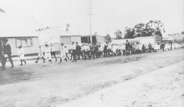 Ringwood and District Historical Society
Photograph, Ringwood School banner carried by children marching in procession past coolstore on Maroondah Highway, Ringwood, near the Wantirna Road corner. c.1920
-
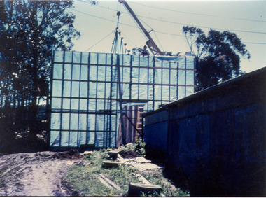 Southern Sherbrooke Historical Society Inc.
Photograph - Photo-colour- construction of coolstore
Colour photograph of construction on a cool storage shed at the Montague orchard, Narre Warren North. A crane can be seen behind the wall. Trees surround the area.