Showing 55 items matching "dargo"
-
 Kiewa Valley Historical Society
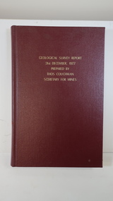
Book - Geographical Survey, Geographical Survey Report 31st Dec. 1977 prepared by Thos. Couchman Secretary for Mines
Office of Mines published progressive reports on the Geological Survey of parts of Victoria.This book includes a chapter on 'Dargo and Bogong' Pages 96 - 117 and includes a fold out map of this area. These pages show heavy use.Hard deep red cover with gold printed title located at the centre top. Bound with spine blank. 217 pages. Date 1878 First chapter and some pages have pencil marks including page 97.geological survey 1878, dargo, bogong -
 Lakes Entrance Historical Society
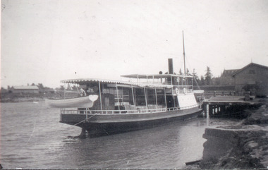
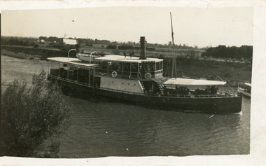
Photograph - S.S. Dargo, 1919
Black and white photograph showing steamer Dargo berthed at the Port of Sale, wharf and port buildings on right of ship, roof of St Mary's Catholic Cathedral visible beyond shed. Sale Victoriajetties, ships and shipping, waterfront -
 Lakes Entrance Historical Society
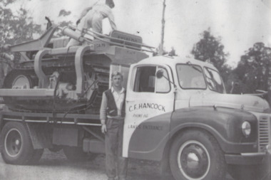
Photograph - Hancock Trucking, Jack Corbett and Ted Jackel, 1950 c
Black and white photograph of Jack Corbett and Ted Jackel with Hancocks Austin truck loaded with dozer being transported for Jack Treasure of Dargo High Plain taken during a stop at Stratford Victoriabusinesses, people, transport -
 Lakes Entrance Historical Society
Postcard - Western Wharf, 1930c
Also black and white enlargement 18x25cmBlack and white small format postcard of the Western wharf. Shown on the wharf a shed and signal light. Four boats moored including either Omeo or Dargo. Reflections on calm waters of lake. Lakes Entrance VictoriaOn back 'Western Wharf Lakes Entrance'jetties, waterfront, ships and shipping -
 Lakes Entrance Historical Society
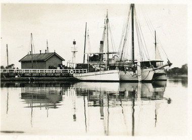
Photograph - S.S. Dargo, 1910 c
Also one enlargement black and white 16 x 25.5 cmBlack and white photograph showing steamer Dargo proceeding along the Sale Canal. Shows houses in left background and front of smaller boat on right side, farmland in background, bush on bottom left of photo. Sale Victoriajetties, ships and shipping, waterways -
 Lakes Entrance Historical Society
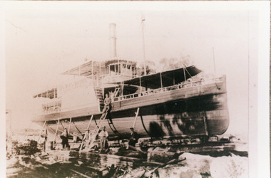
Photograph - SS Dargo, c1910
Black and white photograph showing steamer Dargo on slipway at Paynesville. She appears to be undergoing repairs or overhaul, is propped up on the side with ladder leaning against the hull. Five men in photo. Timber on the site. Paynesville Victoria ships and shipping, slipway, workmen -
 Lakes Entrance Historical Society
Book, Gippsland Heritage Journal No 12 June 1992, 1992
No 12 of Series contains stories of Sealers Cove, Dargo, biographical details of Edward Lees, Surveyor, Lucy Way, photographer, Leah Liddiard and Buchan Charlie, bushranger also information on early Gippsland Newspapers Photographs and maps included.settlers, bibliography, photography, periodicals -
 Bendigo Historical Society Inc.
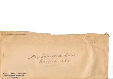
Document - MCCOLL, RANKIN AND STANISTREET COLLECTION: NEW STAR GOLD MINE HARRIETVILLE NL, c1934
McColl Rankin & Stanistreet, New Star Gold Mine Harrietville NL. a/ Department of Mines 20.2.1934 laboratory reports results, 3 receipts attached, list of general expenses, quarter ended 30.4.1934, heading Dargo ''Gold Butterfly'' Gold Butterfly crossed out hand inscription Gold Reefs Syndicate, Wanangatta, Dargo. b/ copy of Purchase agreement of leasehold land for the purpose of mining. Dated 28.6.1934. c/ Payments by R.A. Rankin - Office Account A/C Leases No's. 5187 and 5195 Dargo, Gippsland, prior to exercise of option. Inscription: Paid by New Star Company ?? On ?? 1934 ?? ?? ??. d/ Letter: purchase of Leases No's 5187 & 5195 Black Snake Black Snake Creek, Dargo. Dated: 22.8.1934. e/ letter acknowledging receipt of payment for application of Lease No. 5187, lease will be delayed until precise area is determined. Signed: ?? Rankin. 3 pence stamp for stamp duty attached. Dated: 23.8.1934. f/ Memo, Mr Grelis. Re Leases No's 5187 & 5195 Dated: 4.9.1935. Signed: ?? g/ McColl Rankin & Stanistreet business envelope. Envelope labelled New Star Gold Mine Harrietville. 46.organization, business, gold mine, mccoll rankin & stanistreet, new star gold mine harrietville nl. dargo ''gold butterfly'' gold reefs syndicate, wanangatta, dargo black snake black snake creek 1934 1935 -
 Stratford and District Historical Society
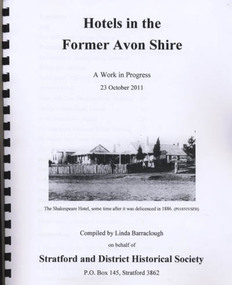
Book, Barraclough, Linda, Hotels in the former Avon Shire: A Work in Progress, 2011
Published book (processed, comb bound) "Hotels in the former Avon Shire: A Work in Progress". 47 pages, illus., A4, Edition May 2012. Includes hotels at Stratford, Nuntin, Delvine, Munro, Stockdale, Cobbanah, Dargo, Grant, Iguana Creek. -
 Narre Warren and District Family History Group
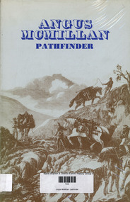
Book, Kenneth Cox, Angus McMillan : pathfinder, 1973
McMillan appointed Protector of Aborigines, Port Albert area. Cattle mustering.non-fictionMcMillan appointed Protector of Aborigines, Port Albert area. Cattle mustering.life on the isle of skye, ewen mcleod, dargo, monaro district nsw, iguana creek -
Lakes Entrance Historical Society
Album, M Fish, East Gippsland Settlement
Many copied from publications of Bairnsdale, Metung, Lakes Entrance, Lake Tyers, including Whiter Family and Whiters Camp Park, Gill Roberts family and "Firefly" S.S. Dargo, P.S. Tanjil, Captain James Bull, Scone Cottage, Bancroft Bay, W H Glover Scarborough Hotel, J.C. Dahlsen, Kitty Johnson, Nelly Blair, Red folder containing 85 images of East Gippsland settlements and activities East Gippsland Victoriawaterways, township, ships and shipping, genealogy -
 Lakes Entrance Historical Society
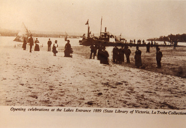
Photograph - Opening Entrance, Eastwood Bros, 1889c
Two other copies in good order - b & w 14 x 20 cm, black and white 20 x 25.5 cm both have tear marksSepia photograph showing steamers at wharf near newly opened Entrance. People on steamers and wharf and on beach. Town on left background hummocks on right background. Steamer on end of wharf is PS Nell, other steamer SS Dargo?. Two small sailing boats on lake. Lakes Entrance VictoriaOpening celebrations at the Lakes Entrance 1889 (State Library of Victoria, LaTrobe Collection) waterfront, people, celebration -
 Bendigo Historical Society Inc.
Administrative record - Kong Meng Gold Reefs Share Register, 1935 to 1936
Three hundred and fifty three page share register, dark green cover, buff bindings. On spine of register in gold text, printed on maroon background :" Share Register' and 'Kong Meng Gold Reefs N.L.' printed in gold on brown background. Alphabetical index of share holders in front of register. Dates range from 1935 to 1936. Share register is part of the Margaret Roberts Collection. bendigo, gold mining, shareholders, share transfers, kong meng gold reefs, dargo, margaret roberts collection, mccoll rankin and stanistreet -
 Bendigo Historical Society Inc.
Document - MCCOLL, RANKIN AND STANISTREET COLLECTION: NEW STAR GOLD MINE HARRIETVILLE NL, 1935
McColl Rankin & Stanistreet, New Star Gold Mine Harrietville NL. a/ Agreement to purchase the mining operations and land at Black Snake Creek, Dargo, Mining District of Gippsland. For Mining Leases numbers 5187 & 5195, 31 acres. The purchaser Company is to be called Kong Meng Gold Reefs NL. Dated: 16/2/1935. Signed: J A Michelsen?, C Kingsley?, J Stanistreet, E R Grelis & ??? Inscriptions: Signed sealed and delivered by the said Ronald Alexander Rankin in the presence of E R Grelis. b/ Leasehold. Transfer of Land situated in the Parish of Dargo County of Dargo Mining District of Gippsland from New Star Gold Mine Harrietville NL to Kong Meng Gold Reefs NL. Dated: 12/3/1935. Signed: G ??, Geo ??, Stanistreet, G ??, Jamie Jeps ? Markings: pencil line through Gold Mining Lease No. 5187 change to a Leasehold Estate, line through January to be changed to March. c/ Indenture (copy of b/ with adjustments made) New Star Gold Mine Harrietville NL with Kong Meng Gold Reefs NL. Dated 13/3/1935. Signed: G ??, Geo ??, Stanistreet, G ??, Jamie Jeps ?, Stanistreet. d/ Carbon copy of a/. Signed: J A Michelsen?, C Kingsley?, J Stanistreet, E R Grelis & ??? Inscriptions: Signed sealed and delivered by the said Ronald Alexander Rankin in the presence of E R Grelis, J Stanistreet. e/ Indenture, agreement between New Star Gold Mining Harriet NL and Kong Meng Gold Reefs NL, was on the 9/3/1935 registered and Incorporated under the Companies act 1928 Part 2. Signed: E R Grelis, J Stanistreet, G ??, Geo ??, Stanistreet, G M?, Stanistreet. Dated: 12/3/1935.organization, business, gold mine, mccoll rankin & stanistreet new star gold mine harrietville nl black snake creek parish of dargo county of dargo mining district of gippsland mining leases numbers 5187 & 5195 kong meng gold reefs nl 1935 -
 Old Gippstown
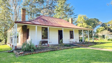
Building - Bushy Park
13 August 1843 First application for the Bushy Park run appeared in the “Port Phillip Gazette”. It was taken up by Angus McMillan, who took up the Boisdale run across the Avon River at the same time, for his employer Lachlan Macalister. This house was built in 1848. March 1844 Licence to Bushy Park granted to McMillan. It consisted of 16,000 acres. Late 1840s Bushy Park homestead built for McMillan by Andrew Martin and Matt McCraw. High local historic significance as associated with major pioneer and a very old white settlement in Gippsland.A square shaped timber house, with a corrugated iron roof over shingles. It has a verandah that covers both the front and sides of the house. The house is contructed of redgum timber, and internally has four rooms.National Trust of Australia Plaque - Bushy Park Homestead - Class 'C'mcmillan, angus, old gippstown, west gippsland, gippsland, gippsland heritage park, goldfields, victorian era, moe, historical village, wellington shire, avon river, boisedale, briagolong, dargo, murdoch mackintosh, national trust, andrew martin and matt mccraw., latrobe valley, old gippstown heritage park, gunaikurnai, latrobe city council -
 Bendigo Historical Society Inc.
Document - MCCOLL, RANKIN AND STANISTREET COLLECTION: NEW STAR GOLD MINE HARRIETVILLE NL, SOUTH BLUE CONSOLIDATED SYNDICATE
McColl Rankin & Stanistreet, New Star Gold Mine Harrietville NL. Collection of documents in envelope. a/ Agreement with the unregistered mining syndicate South Blue Consolidated Syndicate and Gold Exploration (Victoria) Co ML application No. 9982 for a Gold Mining Lease of land at Bendigo on Southern Extension of the Sheepshead or Red White & Blue Line of Reef. Dated: 17/6/1932. Signatures: James Phillips, Stanistreet, J M Leed, C J Michelsen, Jardine?? MacKay. 2 pages. b/ Harry Raymond Johnson & Ellis Douglas McDonnel Doyle on behalf of a No Liability Company to be formed, application for Gold Mining Lease NO. 7514 (Beechworth). Vendors are taking steps to a Company to be entitled New Star Gold Mine Harrietville. Signed: ??, E? McDoyle, ??, McColl Rankin & Stanistreet, ?? Dated:1/5/19/33. 2 pages. c/ Indenture between Ellis Douglas McDonnell Doyle, Harry Raymond Johnson and New Star Gold Mine Harrietville NL the company was formed on 27/6/1933 registered and incorporated. Dated 28/6/1933. Signed: Ke? E D M Doyle, Murphy, Mary R Johnson, J Nicolsen, G? Stanistreet. 2 pages. d/ Memo attached to 2-page letter. Re: adjustment of number of shares for Mr. King. Letter acknowledging receipt of paid shares. Dated 25/7/1933. Signed C B King,?? Page 2 lists brokerage etc. for shares. Dated 11/7/1933. e/ Memo & 3-page letter. Memo re surveyor for Dargo. Allotted shares exceeds available shares. Letter: To Wonnangatta Gold Reefs Syndicate regarding purchase of lease hold property in Mining District of Gippsland. Dated 28/6/1934. Signed ?? Page 2, Balance of monies advanced from R A Rankin. Page 3, costs Re Golden Butterfly Mine. f/ Agreement to lease property in Mining District of Gippsland Mining Lease No's 5187 & 5195 Black Snake Creek Dargo, blue print map of Mine included of No.5187. Dated 28/6/1934. Signed: Keohan?, ??, G ?, Geo Kingsley, Stanistreet. 4 pages. g/ An option to purchase certain Applications for Gold Mining Leases. Date: 28/6/34. Signitures: ? M Neill, ??, G ?, J Nichelsen, Stanistreet. 2 Pages.bendigo, gold mining, south blue consolidated, mccoll rankin & stanistreet -
 Federation University Historical Collection
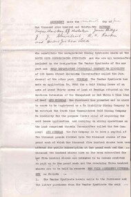
Book, Mines Department, Victoria, Deep Leads of Victoria, 1937, 1937
Charcoal green soft covered book of 64 pages. Contents include Ballarat, berry Consols, Canadian Lead, Castlemaine-Daylesford System, Chiltern, Duke of Cornwall Mine, Dyke's Freehold, Frenchman's Lead, Garibaldi Shaft, Glenfine, Guidlford, Hepburn Estate Co., Hepburn Home Paddock, Italian Gully, Henderson's Lead, Langi Logan, Leigh Consols, Sebastopol Plateau; Talbot, Woady Yalloak, A definition of a deep lead, formation of deep leads, water in deep leads, methods of deep lead mining (Tunnelling, Deep sinking, Chiltern method of working, Ballarat method of working), sampling washdirt and gravels, Balmoral, Mt William, Stawell, Moyston, Great Western, Ararat, Raglan, Wimmera Valley, Landsborough, Cardigan, Haddon, Beaufort, Waterloo, Avoca, Lamplough, Caralulup, Ballarat West, Ballarat, Smythesdale, Glenfine, Illabarook, Durham Lead, Morrison's Lead, Bullengarook, Berry-Moolort-Loddon System, Clunes, Creswick, Spring Hill, Bullarook, Castlemaine - Daylesford, Majorca, Carisbrook, Timor, Burnt Creek Tributary, Tarnagulla, Marong, Rheola, Inglewood, Huntly, Coliban, Campaspe, Goulburn Lead System, Ovens Valley System, Mitta Mitts, Kiewa Valley, Tarago, Tanjil, Moondarra, Bogong, Dargo High Plains, glossarymining, deep leads, mines department, squire, leigh consols, chiltern, duke of cornwall mine, dyke's freehold, frenchman's lead, garibaldi shaft, glenfine, guidlford, hepburn estate co., hepburn home paddock, italian gully, henderson's lead, langi logan, sebastopol plateau, talbot, woady yalloak, tunnelling, deep sinking, chiltern method of working, ballarat method of working, sampling washdirt. gravels, balmoral, mt william, stawell, moyston, great western, ararat, raglan, wimmera valley, landsborough, cardigan, haddon, beaufort, waterloo, avoca, lamplough, caralulup, ballarat west, ballarat, smythesdale, illabarook, durham lead, morrison's lead, bullengarook, berry-moolort-loddon system, clunes, creswick, spring hill, bullarook, castlemaine - daylesford, majorca, carisbrook, timor, burnt creek tributary, tarnagulla, marong, rheola, inglewood, huntly, coliban, campaspe, goulburn lead system, ovens valley system, mitta mitta, kiewa valley, tarago, tanjil, moondarra, bogong, dargo high plains -
 Federation University Historical Collection
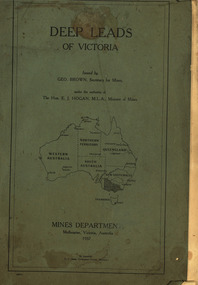
Map, Robert Brough Smyth, Sketch Map of the Colony of Victoria, c1871, c1872
This map includes the population of each County in Victoria according to the 1871 Census, as well as the population of each Australian colony and New Zealand. Telegraph Route is given in a detail at the top right. victoria, victorian counties, robert brough-smyth, telegraph, population, bourke, rodney, dalhousie, evelyn, mornington, buln-buln, tanjil, dargo, delatite, moira, bogong, bendigo, gunbower, grant, talbot, hampden, heytesbury, polwarth, ripon, kara-kara, gladstone, grenville, croajingolong, tambo, benambra -
 Federation University Historical Collection
Book, Stanley B. Hunter, Memoirs of the Geological Survey of Victoria No 7., The Deep Leads of Victoria, 1909
Pink paper covered book by Stanley Hunter, Engineer in Charge of Boring Operations. Contents include tunnelling, deep sinking, the Chiltern Method, the Ballarat Method, Stawell, Ararat, Moyston, Raglan, Wimmera, Landsborough, Avoca, Ballarat West Leads, Berry-Moolort-Loddon Lead System, Clunes, Creswick, Bullarook Affluent, Corinella, Daylesford-Castlemaine Tributary, Majorca-Carisbrook tributary, Huntly, Coliban, Campaspe, Rutherglen., Smythesdale, Durham Lead, Tanjil, Evolution of Mining Machinery, size of claims, Definition of a Deep Lead, Discovery of Gold in Victoria, Geographical Position of Deep Leads, Water in Deep Leads, Methods of Deep Lead Mining, Cost of Deep Lead Mining, Stawell, Ararat, Moyston, Raglan, Wimmera, Landsborough, Avoca, Ballarat West, Berry, Springs Hill, Loddon Valley, Charlotte Plains, , Timor, Burn Creek, Huntly, Colinan, Goulburn, Ovens Valley, Chiltern, Indigo, Morrison's Lead, Plans include: geological Map of Stawell, ararat, Raglan and Landsborough; Kempson's Freehold Mine, Stawell; Geological Map of Beaufort, Avoca, Maryborough, Ballarat west, Berry-Moolort, Loddon, Creswick, Marong, &c; Cardigan Propriety Gold Mine; Working Miners United Gold Mine, Homebush; Hepburn Deep Lead Plan; Madame Berry West Mine; West Berry Consols Mine; Spring Hill and Central Leads; Berry Consols Extended Mine; Loddon Valley Goldfields; Chalk's No 3 Mine; Charlotte Plains Considated Mine; Duke United Mine; Geological Map of Bendigo, Huntley, Campaspe, Malmsbury, Kyneton, trentham, &c; Geological Map of Chiltern, Rutherglan, Eldorado, Beechworth, &c; Chiltern Valley Gold Mine; Wallace Chiltern Valley Consols Mine; great Southern and Chiltern Valley United Mine; great Northern extended Consols; Prentice and Southern deep Leads; Glenfine South Gold Mine; Geological map of Pitfield, Rokewood, Mt Mercer, Ballark, Meredith, &c.; McEvoy Mine; Dargo . . . . . . . . . . . . . . . . . . . . . . . mining, deep leads, squire, tools, gold panning, gold cradle, cradling, puddling, tubbing, mining shaft, shaft sinking, whip, horse whip, whim, horse whim, chalk's no. 1 mine, maryborough, mining cage, shaft, mining trucks, maryborough, washdirt, puddler, tunnelling, deep sinking, chiltern method of working, ballarat method of working, sampling washdirt. gravels, balmoral, mt william, stawell, moyston, great western, ararat, raglan, wimmera valley, landsborough, cardigan, haddon, beaufort, waterloo, avoca, lamplough, caralulup, ballarat west, ballarat, smythesdale, glenfine, illabarook, durham lead, morrison's lead, bullengarook, berry-moolort-loddon system, clunes, creswick, spring hill, bullarook, castlemaine - daylesford, majorca, carisbrook, timor, burnt creek tributary, tarnagulla, marong, rheola, inglewood, huntly, coliban, campaspe, goulburn lead system, ovens valley system, mitta mitta, kiewa valley, tarago, tanjil, moondarra, bogong, dargo high plains -
 Ringwood and District Historical Society
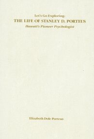
Book, Elizabeth Dole Porteus, Let's Go Exploring: The Life Of Stanley D. Porteus - Hawaii's Pioneer Psychologist, 1991
White hard covered book. Biography by daughter-in-law of Stanley Porteus, pioneer of modern psychology and one-time resident of Ringwood, Victoria. SUMMARY NOTES. Stanley David Porteus was born in Box Hill, Victoria, Australia in 1883, the only son of a Methodist minister. Like other now large suburbs of Melbourne such as Canterbury, Mitcham and Ringwood, Box Hill was a mere village. Each was surrounded by bush. He grew up like most Australian boys with a love of sport and, although lightly built, did quite well at Australian Rules football and was above average at cricket. He became a schoolteacher with the Victorian Education Department. Promotion within the department depended on experience gained at teaching in tiny rural schools so he applied for such a position at Glenaladale, on the Dargo Road, some 35 miles north west of Bairnsdale. He walked about 6 miles from the nearest railway station at Fernbank to find the school surrounded by virgin forest with only one dwelling in sight. Attached to the school were lean-to rooms that were to be his residence for the next 2 ½ years. He was fascinated by the nearby Den of Nargun and Bull Creek, which joined the Mitchell River in a deep gorge containing a profusion of rainforest vegetation. While at Glenaladale, he met Frances Evans who became his wife. To seek promotion, he left Glenaladale and taught at Leneva and Benambra. While at the latter school, he learned of a position becoming available as superintendent of special schools in Melbourne. As the available means of transport, coach and horses to Bairnsdale, then by train to Melbourne, would not get him to Melbourne before the close of applications, he borrowed a bicycle and rode through the bush to his in-laws home at Lindenow and thus made it before the deadline. He was successful in his application and it set him on a course that lead to him becoming Australia's first Clinical Psychologist. His work, particularly, the development of the Porteus Maze Test, attracted the attention of American educators and he was offered an appointment for a year at Vineland Training School in New Jersey. On a stopover in Honolulu, he was impressed to the extent that he expressed a desire to work there. Not the least of its attractions was the mix of races that offered opportunities to study psychological differences, if any, between various races. His wish was to be granted unexpectedly as he was, in 1919, invited to Honolulu to set up a Psychological and Psychopathic Clinic at the University of Hawaii. From his home in the hills north of Honolulu, on December 7th 1941, he saw the Japanese attack on Pearl Harbour. He lived there until his death in about 1980. -
Federation University Historical Collection
Reports, Big Cat sightings (dates), 1989
Research of dated sightngs of Big cats in Victoria from 1868-1989. australian mythical animals collection, david waldron, dse, big cats, panthers pumas, nuggety, gippsland, black cats, tasmanian tiger, marysville, wood's point, thylacine, south gippsland, felid, gippsland big cat, kelvin healey, peter hall, sherbrooke forest, woodside, walaces flat, mountain lion, heyfield, mt taylor, walhalla, mt selma, warrnambool, kyneton, korumburra, canadian forest, grampians, panton hill, beaconsfield, apollo bay, forrest, victoria valley, rapanyup, dargo, inglewood, doncaster east, tidal river, cape bridgewater, walkerville, dooen, st arnaud, lake bung bong, mitta mitta, moliagul, emerald, kinglake, cape otway, dereel, leonard's hill, daylesford, korweinguboora, lal lal, noojee, eltham, lancefield, trentham, daisy hill, tanjil south, wonthaggi, cockatoo, warrenheip, greendale, howqua, lake buchan, melville caves, portland, mt elephant, morwell, navarre, yarram, yandoit, moonambel, maryborough, taravale, coghill's creek, trentham, carisbrook, inglewood, warrenmang, yarragon, creswick, emerald, stawel, clunes, majorca, heathcote, talbot, daylesford, newham, broadford, peter chapple -
 Victorian Aboriginal Corporation for Languages
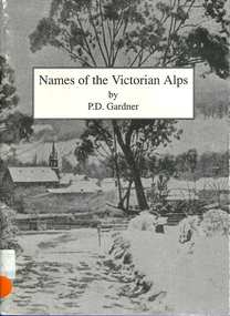
Book, P D Gardner, Names of the Victorian Alps : their origins, meanings and history, 1991
Gives a comprehensive account of the origins of local names in the area. Anecdotes of interesting pieces of history.Maps, b&w illustrations, b&w photographsjaitmathang, minjambuta, djilimatang, ngarigo, brabiralung, braiakaulung, yuin, gunnai, lake tyers, dargo river, omeo, bright, swifts creek, benambra, ovens valley, mount hotham, mount nugong, wonnangatta station -
 Wodonga & District Historical Society Inc
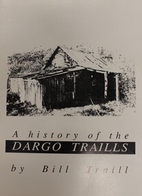
Book - A History of the Dargo Traills, Bill Traill, 1993
A family history of the Traill Family, descendants of Alexander Groat Traill and Julianna Traill nee Bulley. The Traill Family originated from the Orkney Islands, Scotland. They settled around the area of Dargo in Gippsland, Victoria. This publication also provides background explaining their Scottish ancestors.non-fictionA family history of the Traill Family, descendants of Alexander Groat Traill and Julianna Traill nee Bulley. The Traill Family originated from the Orkney Islands, Scotland. They settled around the area of Dargo in Gippsland, Victoria. This publication also provides background explaining their Scottish ancestors.traill family, alexander groat traill, orkney genealogy, pioneers dargo -
 Wodonga & District Historical Society Inc
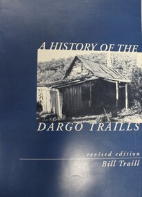
Book - A History of the Dargo Traills: with a background on the Traills of Orkney, Bill Traill, 2000
A family history of the Traill Family, descendants of Alexander Groat Traill and Julianna Traill nee Bulley. The Traill Family originated from the Orkney Islands, Scotland. They settled around the area of Dargo in Gippsland, Victoria. This publication also provides background explaining their Scottish ancestors.non-fictionA family history of the Traill Family, descendants of Alexander Groat Traill and Julianna Traill nee Bulley. The Traill Family originated from the Orkney Islands, Scotland. They settled around the area of Dargo in Gippsland, Victoria. This publication also provides background explaining their Scottish ancestors.traill family, alexander groat traill, orkney genealogy, pioneers dargo -
 Wodonga & District Historical Society Inc
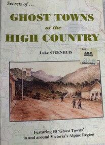
Book - Ghost Towns of the High Country, Luke Steenhuis, 1998
Stories and information about former towns in and around Victoria's Alpine Region. Towns include Boggy Creek, Brandy Creek, Brocket, Brookville, Buckland, Buckland Upper, Bulgoback, Bulltown, Hogtown, Bullumwaal, Canvastown, Cassilis, Cobbannah, Copenhagen, Dargo High Plains, Dartmouth, Deptford, Gibbo River, Gladstone, Glen Dart, Glen Valley, Glen Wills, Good Luck Creek, Granite Flat, Grant, Hinnomunjie, Howittville, Jeff Davis, Lightning Creek, Louisville, Mayford, Merrijig Creek, Mitchelldale, Mount Elmo, Nugong, Sassafras, Saltpetre, Staleyville, Stirling, Store Creek, Summer Hill, Sunnyside, Tabberabbera, Talbotville, Thiel Town, Tongio West, Waterford, Wentworth River, Winchester, Wombat, Wongungarra, Zulu Creek.non-fictionStories and information about former towns in and around Victoria's Alpine Region. Towns include Boggy Creek, Brandy Creek, Brocket, Brookville, Buckland, Buckland Upper, Bulgoback, Bulltown, Hogtown, Bullumwaal, Canvastown, Cassilis, Cobbannah, Copenhagen, Dargo High Plains, Dartmouth, Deptford, Gibbo River, Gladstone, Glen Dart, Glen Valley, Glen Wills, Good Luck Creek, Granite Flat, Grant, Hinnomunjie, Howittville, Jeff Davis, Lightning Creek, Louisville, Mayford, Merrijig Creek, Mitchelldale, Mount Elmo, Nugong, Sassafras, Saltpetre, Staleyville, Stirling, Store Creek, Summer Hill, Sunnyside, Tabberabbera, Talbotville, Thiel Town, Tongio West, Waterford, Wentworth River, Winchester, Wombat, Wongungarra, Zulu Creek.ghost towns, high country victoria, pioneers, history victoria