Showing 623 items matching "deposit"
-
 Marysville & District Historical Society
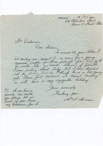
Letter (item) - Hand written letter, Mrs A. Munroe, 10-11-1934
A digital copy of a hand written letter enclosing the deposit for accommodation at Marysville House and requesting if Marysville House has provision for the guests' private car. Marysville House was built in the late 1920s by Arthur Dickinson.A digital copy of a hand written letter enclosing the deposit for accommodation at Marysville House and requesting if Marysville House has provision for the guests' private car. Marysville House was built in the late 1920s by Arthur Dickinson.marysville, victoria, australia, marysville house, arthur james dickinson, grace dickinson, arnold spooner, eileen marie spooner, eileen marie dickinson, grace sweetland, eric dowdle, elsie may denton, elsie may dickinson, peter dickinson, linda dickinson, 2009 black saturday bushfires, letter, mrs a. munroe -
 Bendigo Historical Society Inc.
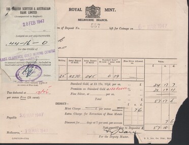
Document - MCCOLL, RANKIN AND STANISTREET COLLECTION: EAST CLARENCE GOLD MINING CO. - BANKING, 1941/47
Document; folder contains loose bank deposit butts and gold deposit forms.MCCOLL RANKIN & STANISTREETorganization, business, bendigo businesses, mccoll rankin & stanistreet -
 Federation University Historical Collection
Photograph - coloured, Department of Lands and Survey, Portion of Victoria showing auriferous areas and mineral localities, 1935, 1935
Map included with book "Victoria: Gold and Minerals" issued by Mines Department Victoria, 1935Fold out coloured mapYellow mark indicating depositsvictoria, auriferous areas, mineral localities, department of mines, tin, antimony, copper, silver lead, tungsten, manganese, platinum, iron -
 Port Melbourne Historical & Preservation Society
Document - Bank Passbook, Depositors Passbook Commonwealth Savings Bank of Australia, 17.10.1962
Passbook in the name of Mrs Maria VASSALLO, trustee for Miss Mary VASSALLO. Passbook used from 1965 to July 1966. Changeover from pounds to decimal currency Commonwealth Savings bank of Australia savings book for Mrs Maria VASSALLO 1965 to 1966Handwritten deposit and withdrawals entriesbusiness and traders, banks, commonwealth savings bank of australia, maria vassallo, mary vassallo -
 Federation University Historical Collection
Book, William Harvey Emmons, The Principles of Economic Geology, 1940, 1940
The book was used by Charles Bacon who studied at the University of Nevada in the late 1930s/early 1940s. Bacon worked at Bunker Hill Mines and Kellogg Idaho, before arriving in Australian in 1951. He worked for CN Myers, a company involved with paper converting. CN Myers was a family business (on Charles Bacon's maternal line). William Emmons was Professor and head of Geology and Mineralogy at the University of Minnesota; Director of Minnesota geological Survey; and previously Geologist, Section of Metalliferous Deposits, United States Geological Survey.Maroon soft covered book of 529 pages. Chapters include Magmatic Segregations, Pegmatities, Hypothermal Deposits, Sedimentary Depostis, Openings in Rocks, Metasomatic Processes, Mineral Associations and more.Inside front cover "Charles Bacon 1940 Lincoln Hall Ass. University of Nevada Reno, Nevada"charles bacon, mining engineering, metallurgy, university of nevada, mackay school of mines, geology, california -
 Bendigo Historical Society Inc.
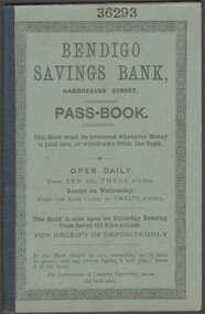
Document - Bendigo Savings Bank Passbook, 14/01/1893
In 1862 the Bendigo Penny Savings Bank was opened. It later was simply called the Bendigo Savings Bank. Ten months after its opening it reported that it had monthly deposits of 2 pounds, 12 shillings and 4 pence. (Jan 1863)Bendigo Savings Bank Passbook No. 36293 belonging to Miss Marguerite Kane. Used for deposits and withdrawals between January 1893 and November 1896. handwritten entries. Green card cover bound with cloth tape. Cover includes opening times. Rules and Regulations of Savings Banks in Victoria included at front of passbook.savings banks, passbook -
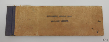 Flagstaff Hill Maritime Museum and Village
Financial record - Bank Deposit Book, Commercial Banking Company of Sydney Limited, Pre Jan, 1932
This bank deposit book was used for financial deposits made between1932 and 1936. The funds were deposited into the Emergency Account of the Warrnambool Harbour Board, lodged at the Warrnambool Branch of the Commercial Banking Company of Sydney Limited (CBC). James Menzies, Pilot and Harbour Master from 1929, would have used this deposit book when he was appointed as Acting Secretary of the Warrnambool Harbour Board in 1932. He held this office until the Board ceased in 1936. Warrnambool’s CBC Manager during this time was L E Whitney; he was Manager from 1924 to 1939. The Commercial Banking Company of Sydney Limited opened in 1893. On January 1, 1927 the CBC amalgamated with the Bank of Victoria. In 1981 the CBC merged with the National Bank of Australasia Limited and on January 1, 1983 the bank started using the abbreviated name of the National Australia Bank (NAB). Warrnambool Harbour Board The Warrnambool Harbour Board was constituted by Order of Council on May 29, 1928, under the Harbour Board’s Act of 1927, taking over from the Ports and Harbours Branch of the Public Works Department of Victoria. The Board was then the only body with power to manage and control the whole Port, including shipping, facilities upkeep and improvements of the port. The work it carried out involved dredging, building of port facilities and drafting of port regulations, and collecting taxes, tolls, rates and charges. The Board was officially dissolved on June 30, 1936, at which time the Public Works Department again had control. The Warrnambool Harbour Board had rented out the Lighthouse Keeper’s Quarters from the 1920s until 1936, when the Board closed down. However, rentals continued with other currently unknown landlords until Flagstaff Hill Maritime Village opened in 1975 and began renovating the Cottage, in stages. This financial record book is significant for its association with the historic financial records of the Warrnambool Harbour Board and relates to the maritime history of Warrnambool, in particular with the Port of Warrnambool.Warrnambool Harbour Board Emergency Account Book containing deposit receipts and blank forms for the Commercial Banking Company of Sydney Limited. Rectangular book has buff coloured card covers, white pages with pre-printed text and lines and black tape binding on left side. Inscriptions stamped on front cover, receipts and unused, pre-printed pages. Approximately half of the pages have been filled in, and the deposit slips removed, leaving the receipt end attached to the book. There are two lose receipts stapled into the book. Hand written receipts date from 21 JAN 1932 to 25 JULY 1936. Stamped "WARRNAMBOOL HARBOUR BOARD / EMERGENCY ACCOUNT" "WARRNAMBOOL VIC" "EMERGENCY ACCOUNT / WARRNAMBOOL HARBOUR BOARD" Also, each receipt has the bank's stamp with its details and the date on it. Hand written details are on each completed receipt.warrnambool, shipwrecked-coast, flagstaff-hill, flagstaff-hill-maritime-museum, maritime-museum, shipwreck-coast, flagstaff-hill-maritime-village, shipwrecked-artefact, book, warrnambool harbour board, emergency account, commercial banking company os sydney ltd, bank deposit book, financial record, financial management, stationery, deposit book, public works department, ports and harbours, commercial banking company of sydney ltd., james menzies, harbour master, l e whitney, cbc manager warrnambool, harbour board act, port of warrnambool, warrnambool harbour, lady bay, harbour pilot -
Lakes Entrance Historical Society
Financial record - Documents, Nungurner Hall Committee, 1986
Receipt book 514 used 10th July 1980 to 24th October 1986 yellow cover, red bound spine, 26 receipts issuedOne receipt book and two bank deposit booksminute books -
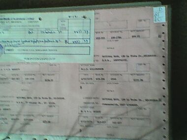 Ambulance Victoria Museum
Document, Victorian Ambulance Service, Bank Pay Run, 4 December 1973
Pink dot matrix document with printer holes on both sides. 8 perforated pages and white National Bank of Australasia receipt stapled right corner.DEPOSIT FOR ACCOUNT AT THE NATIONAL BANK OF AUSTRALASIA LIMITEDfinance -
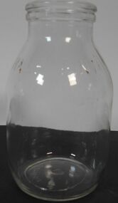 Bendigo Historical Society Inc.
Domestic object - Milk Bottle 1/2 pint
Half pint glass milk bottle - Australian Glass manufacturer - No Deposit No return - AGM M18 PBM -227milk bottles, 1/2 pint bottle, agm -
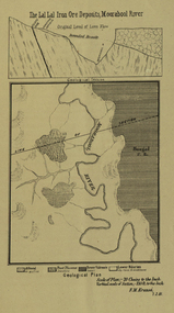 Federation University Historical Collection
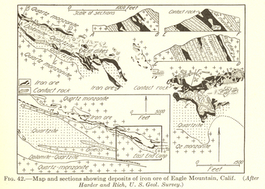
Plan, Lal Lal Iron Ore Deposits, Moorabool River, 1881
This plan was printed in the Ballarat School of Mines Annual Report were Ferdinand Krause was a professor.Printed plan showing iron ore deposits at Lal Lal.lal lal ore, moorabool river, ferdinand krause -
Stawell Historical Society Inc
Map, Plan Shewing Auriferous Deposits and Reefs (Map of Water Races), c1878
Plan Shewing Auriferous Deposits and Reefs (Map of Water Races)stawell, water -
 Orbost & District Historical Society
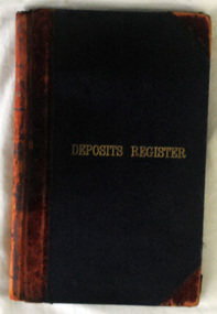
Work on paper - Book - deposits register, Dept. of Forestry, Victoria
This Register has many inscriptions for Forestry activities in the Orbost region, such as Sleeper Cutting Licenses and other licensed activities such as Wattle Bark Stripping, Saw Mills, Logging Licenses, Sleeper Off-cuts. It contains the names of people involved in these activities, the amounts of money they paid to the Forestry, and dates. This Register appears to start in 1919 and end in 1978. An excellent resource for research into the forestry industry in the Orbost district since this Register contains the names of men who paid license fees to the Forestry Dept. to allow them to work in the forests in various activities such as sleeper cutting, wattle bark cutting, saw mills, logging. A hard cover ledger, dark blue/black cover with red binding. The words DEPOSITS REGISTER are printed on the front cover and also on the binding. The ledger's pages are ruled in red for DEPOSITS and REFUNDS. forestry, orbost, sleeper cutting, wattle bark cutting, saw mills, logging -
 Bendigo Historical Society Inc.
Document - GRAHAM HOOKEY COLLECTION: COMMERCIAL BANK OF AUSTRALIA PAPER BAGS
Six paper bags of the Commercial Bank of Australia Limited for deposits $10 of ….cents coins. Three small paper bags of the Commercial Bank of Australia limited for deposits of $ 2 of 5 cents coins.numismatics, equipment, bags -
Whitehorse Historical Society Inc.
Document, Mitcham Repertory Group Papers, 1993
Deposited by Max Grant. Includes annual reports; constitution; treasurers reports.drama, mitcham repertory group, grant, max -
Unions Ballarat
Correspondence re receipts, printed balance sheet of the London Dock Labourers' Relief fund, 6 September 1889-18 February 189?
The 1889 London Dock Strike grew from unrest about poor living conditions as a result of the casualised labour force. Money raised across Australia (30,000 pounds) helped to support striking workers to continue the action and feed their families. The strike led to the formation of the General Labourers' Union and strengthened unionism amongst dockers.The London Dock Labourer's Strike correlates with significant National growth in the trade union movement.Includes chequebook, bank deposit slips and rough notebook with Wilson's memoranda. btlc, ballarat trades and labour council, unions, strikes, london dock strike, casualisation, actu, ballarat trades hall -
 Melton City Libraries
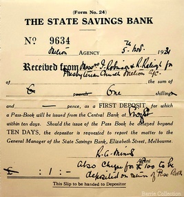
Financial record, Melton Presbyterian Church cheques, 1928,1962
AJ Raleigh and Treasurer Keith Robinson names are on the State Savings Bank cheque. Cheque for the Annual Hospital Appeal from the church and deposit to the State Savings Bankchurches -
 Phillip Island and District Historical Society Inc.
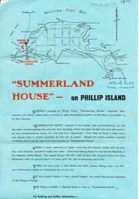
Document, Summerland House, 1975
Summerland House BrochureSummerland House brochure advertising holidays with points of interest to visit. Receipt for $40.00 deposit summerland house, summerland phillip island, j & e perrin, summerland guesthouse phillip island, tourist attractions -
 Federation University Historical Collection
Map - Geological, Tallangatta, New South Wales: 1:250,000 Geological Series, SJ 55-3, 1966, 1966
Compiled by the Geological Survey of N.S.W., Division of Regional Geology. Topographical base compiled from Snowy Mountains Hydro Electrical Authority, Department of Lands, County maps and Snowy Lease Map. Other sheet adjoin this map. There are 13 formation sections grouped into 9 - Quaternary, Tertiary, Middle Devonian, Lower to Middle Devonian, Lower Devonian, Upper Silurian, Silurian, Upper Ordovician and Ordovician.Large coloured map showing geological features, faults, bores, rivers and mineral deposits.Scale of map, longitude and latitude, river names. "Tallangatta 1:250,00" written in black pen.tallangatta, new south wales, geological survey, topographical base, snowy mountains hydro electrical authority, department of lands, snowy lease map, department of mines, quaternary, tertiary, middle devonian, lower to middle devonian, lower devonian, uper siluran, silurian, upper ordovician, ordovician -
 Bendigo Historical Society Inc.
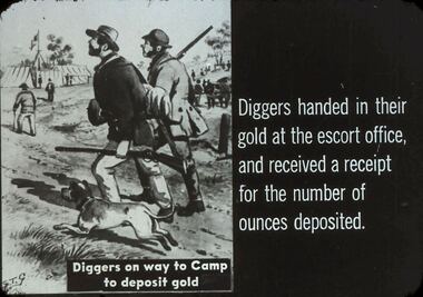
Slide - DIGGERS & MINING. THE GOLD LICENCE, c1850s
Diggers & Mining. The gold licence. The Government Camp. Diggers handed in their gold at the escort office, and received a receipt for the number of ounces deposited. Diggers on way to Camp to deposit gold. Markings: 20 994.LIF. 4. Used as a teaching aid.hanimounteducation, tertiary, goldfields -
Port Melbourne Historical & Preservation Society
Document - Tender, J Fisher, Erection of 40 four-room houses and 40 five-room houses, Port Melbourne, 11 Sep 1923
Tender for erection of 40 four room houses and 40 five room houses . from J Fisher of Elsternwick in 1923 and presented on the City of Port Melbourne's official tendering formWritten across the face in blue : "deposit returned 20/9/23"local government - city of port melbourne, j fisher -
Clunes Museum
Ephemera - LABEL, EBERHARD CO. , CLUNES AND TALBOT, UNKNOWN
LABEL USED BY EBERHARD FOR THEIR DRINK BOTTLESEBERHARD'S LABEL FOR CREAMING SODADEPOSIT 3d REFUNDED WITH THIS LABEL ATTACHED. EBERHARD AND CO. CLUNES - TALBOTlocal history, commerce, labels, eberhard & co. labels -
Clunes Museum
Ephemera - LABEL, EBERHARD CO. , CLUNES AND TALBOT, UNKNOWN
SEE REGISTRATION NO. 2037.1.2SOFT DRINK BOTTLE LABEL FROM EBERHARD AND CO. CLUNES TALBOTDEPOSIT 3d REFUNDED WITH THIS LABEL ATTACHED. EBERHARD AND CO. CLUNES TALBOTlocal history, commerce, labels, eberhard & co. labels -
 The Beechworth Burke Museum
Geological specimen - Fossiliferous Mudstone, Unknown
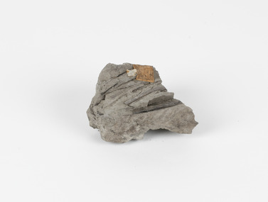
This specimen was found in Cape Patterson, Vic. Cape Paterson is a cape and seaside village located near the town of Wonthaggi, 132 kilometres southeast of Melbourne, in the Bass Coast Shire of Gippsland, Victoria, Australia. These dark, fossiliferous Mudstones were deposited in slow-moving water associated with sedimentary basins & continental shelves. They are rich in carbon which makes them almost black. This is typical of an anoxic, reducing environment such as deep water or stagnant conditions where carbon-rich material would remain unoxidised during subsequent deposition & diagenesis. it has an imprint of a leaf in the rock itself, displaying the fossil of the plant. This specimen is unique due to the leaf impression within the stone itself. Imprint fossils are formed from an organism moving in some way, leaving behind a trace or track. These tracks are preserved when the clay/silt dries slowly and is covered by other sediment. Plants can also leave imprint fossils when they are covered by sediment. The leaf tissue degrades, leaving an imprint of where the leaf once was. This specimen is part of a larger collection of geological and mineral specimens collected from around Australia (and some parts of the world) and donated to the Burke Museum between 1868-1880. A large percentage of these specimens were collected in Victoria as part of the Geological Survey of Victoria that begun in 1852 (in response to the Gold Rush) to study and map the geology of Victoria. Collecting geological specimens was an important part of mapping and understanding the scientific makeup of the earth. Many of these specimens were sent to research and collecting organisations across Australia, including the Burke Museum, to educate and encourage further study.These dark, fossiliferous Mudstones were deposited in slow moving water associated with sedimentary basins & continental shelves. They are rich in carbon which makes them almost black. This is typical of an anoxic, reducing environment such as deep water or stagnant conditions where carbon rich material would remain unoxidised during subsequent deposition & diagenesis. FOSSILIFEROUS MUDSTONE / Locality: Cape Patterson, Victoria | Descriptive catalogue / Pg 27 No 95 / "Grey Clay, / Cape Paterson with leaf impressions' / 15/4/21 C. William /mudstone, cape patterson, leaf imprint, fossilised leaf, fossiliferous mudstone -
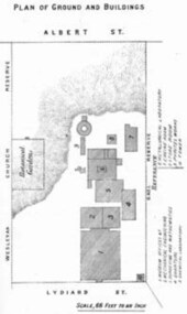 Federation University Historical Collection
Book - Annual Report 1880, The School of Mines Ballaarat Annual Report, 9 February, 1880, 1880
The School of Mines Annual Report, 9 February, 1881, Additional Examination Statute 1880, Balance Sheet, Certificates Granted by Council, Donations and Fees - carriage of, Extracts from Visitors' Book, Fees, Form of Bequest, Honorary Correspondents, Life Governors, Mining and Mineral Contributions Invited - Paper of Particulars, Museum - open to visitors, Office Bearers, Obituary, Report of the Lecturer in Mathematics, Report of the Lecturer in Mining-Land- and Engineering-Surveying, Report of the Lecturer in Mechanical Engineering, Report of the Lecturer in Telegraphy, Report of the Curator of the Museum (with Plans), Report of the Superintendent of Laboratories, Subjects and Lecturers, Subjects and Examiners, Statement of Receipts and Expenditure for the year 1880, Subscriptions and Donations from 1 January to 31 December 1880, The Lal-Lal Iron Ore Deposits - (with Section and Plan)Pale green booklet of 70 pages, Annual Report 1880. Image of Guage Test Tower, Image of The School of Mines, Plan of Ground and Buildings - Albert Street, The School of Mines Ballaarat - The Museum - Plan of Groundfloor, Image of the Lal-Lal Iron Ore Deposits, Moorabool Riverthe school of mines, annual report, additional examination statute 1880, balance sheet, certificates granted by council, donations and fees - carriage of, extracts from visitors' book, fees, form of bequest, honorary correspondents, life governors, mining and mineral contributions invited-paper of particulars, museum open to visitors, office bearers, obituary, report of the lecturer in mathematics, report of the lecturer in mining-land and engineering-surveying, report of the lecturer in mechanical engineering, report of the lecturer in telegraphy, report of the curator of the museum (with plans), report of the superintendent of laboratories, subjects and lecturers, subjects and examiners, statement of receipts and expenditure for the year 1880, subscriptions and donations from 1 january to 31 december 1880, the lal-lal iron ore deposits-(with section and plan), obituary - sir redmond barry - arthur leahy - jacob upfold - john day, mr james oddie, dr. r. f. hudson, john victor, chas. wm. thomas, w. h. shaw, walter d. campbell, ferdinand m. krause, joseph flude, geo. perry, w. hy. barnard, examination statute, his excellency sir wm. f. drummond jervois, charles h. pearson, t. brodribb, professor pepper, james mitchell, robert adam, wm. lant carperter, h. b. de la poer wall, w. h. brokenshire, arthur parker, henry parkinson, c. davies, simon richards, c. v. gorton, c. r. blackett, david jones, wilberforce dyke, ferdinand krause, ballarat school of mines museum, ballarat school of mines museum plan, lal lal ore deposits, moorabool river, william land carpenter, william jervois, william henry tbarnard -
 Federation University Historical Collection
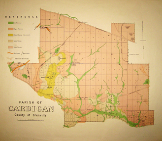
Map - Geological survey, Parish of Cardigan, County of Grenville, c1889
Geological map of the Parish of Cardigan on a cadastral base showing quartz reefs, shafts, alluvial deposits.cardigan, winter's creek, ballarat cattle yards railway, prince of wales park, ballarat, friendly societies reserve, ballarat industrial school reserve, green hill, bunker's hill, sago hill, diamond drill bores, cardigan propriety, half way house, ti tree creek, albion consols, prince imperial, winter's freehold company -
 Federation University Historical Collection
Plan, Parish of Dowling Forest, County of Ripon and Grenville, 19
Scale [1:31 680]. 40 chains to 1 in.Geological map on a cadastral base, showing the occurence of reefs, and alluvial deposits. Relief shown by contours.dowling forest, wyndholm, wyndholm pre-emptive right, miners rest, ballarat racecourse, winter's swamp, police reserve, miner's rest, winters swamp, geology -
 Federation University Historical Collection
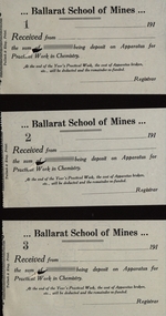
Document - Receipts - Blank, Three blank receipts for apparatus from Ballarat School of Mines
Ballarat School of Mines is a predecessor of Federation UniversityThree blank receipts for a deposit on Apparatus for Practical Work in Chemistry, receipts are number 1 to 3. ballarat school of mines, receipt, apparatus receipts, chemistry, three receipts, blank receipts -
Port Melbourne Historical & Preservation Society
Book - City of Port Melbourne, Electricity Supply, cash book, 1955 - 1967
City of Port Melbourne - Cash Book - Electricity Supply deposit a/c period 1955 to 1967local government - city of port melbourne -
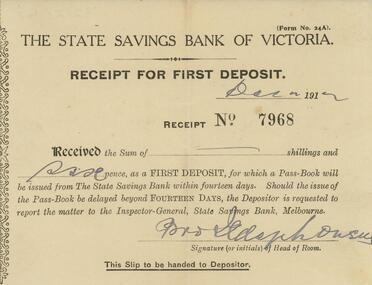 Bendigo Historical Society Inc.
Document - GUINEY COLLECTION: RECEIPT, December 1912
Document. Receipt for first deposit of 6d at the State Savings Bank of Victoria, Dated December 1912.document, memo, receipt for first deposit