Showing 204 items
matching early road transport
-
 Warrnambool and District Historical Society Inc.
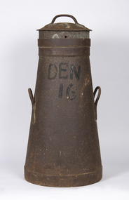
Container - Milk can, Early 20th century
This is a can used for storing milk at a dairy farm for transport to the local butter, milk or cheese factory. It comes from a farm (number 16) in Dennington, a settlement and now a suburb west of Warrnambool. It may have been supplying milk to the Nestles factory at Dennington by a truck or taken to a Nestles depot nearby. The Nestles factory was established in Dennington in 1907 and closed in 2005. This can is an interesting memento of dairying practices in the early to mid 20th century.This is a metal can with a circular base tapering to an open top. It has two handles on the side and a circular lid with a handle. It has a stencil on the side. The entire can is rusted.Den 16milk can, dairying in warrnambool district, nestles factory dennington -
 Warrnambool and District Historical Society Inc.
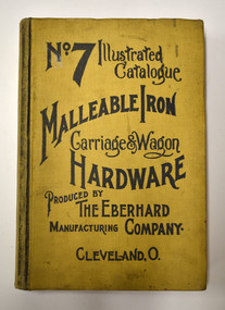
Book - Illustrated Catalogue of Malleable Iron Hardware, The Eberhard Manufacturing Company, No. 7 Illustrated Catalogue Malleable Iron Hardware, 1908
Catalogue from American company of malleable hardware itemsThis is a book of 732 pages. It has a yellow cloth cover with black printing and pages edged in red. The contents contain an index and pages of black and white sketches and text.non-fictionCatalogue from American company of malleable hardware itemscarriage and wagon hardware, eberhard manufacturing company -
 Warrnambool and District Historical Society Inc.
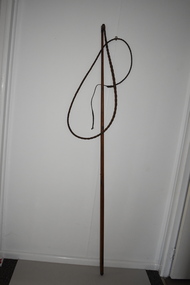
Whip, Bullock Whip, Early 20th century
Bullock teams and bullockies were common sights in Australia in the 19th and early 20th centuries. Bullock teams were used for the transport of heavy goods such as wool, wheat, timber, sugar cane, farm equipment, building supplies etc. and their presence and that of their colourful bullock drivers in the countryside have become part of Australia bush folklore. Bullocks were often favoured over horses as they could pull heavy loads over rough surfaces and were less expensive to maintain. As the bullock teams frequently varied in size (up to 40 bullocks have been recorded in the one team) the whip was always a very long one. This item is of considerable significance as a memento of the days (19th century and early 20th century) when bullock teams were the common form of transport for heavy goods. As in other parts of Australia, bullock teams were a feature of the area around Warrnambool and created much interest when they arrived in the smaller towns. This is a wooden stick, slightly tapered to the top, with a leather binding at the top with a small knob. Attached to the top of the stick is a whip made of plaited leather. The leather is brown and stained and slightly worn. At the end of the whip is a strip of plain leather with a knot at the end. bullocks and bullockies in the western district, warrnambool, history of warrnambool -
 Warrnambool and District Historical Society Inc.
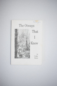
Booklet, Merimbula Easiprint, 1993
This book was written by Roland (Corker) Brown. His forebears were pioneers in the Wyelangta area of the Otway Ranges and he spent most of his life in that region. In this book he has recorded some of the history of the area and his personal recollections, starting from the 1930s when the last of the bullock and horse teams were transporting timber and the old mills were closing. This book is of interest as it gives the history of the Otway Ranges and one man’s story of life in this region in the early to mid 20th century. It will be useful for researchers. This is a soft-cover book of 211 pages. It has a white cover with a black and white photograph of a bush scene and black printing on the front cover. The book contains a poem by the author, two sections of printed material and many black and white photographs. -
 Warrnambool and District Historical Society Inc.
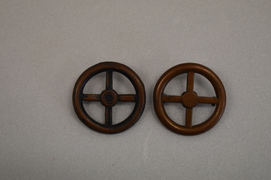
Badges x 2, Wheel Shaped
These badges appear to come from the transport section of the British Army and would have been worn on the shoulder. They would have been in use during the first half of the 20th Century.These badges do not appear to have local significance but are of interest as early examples od British Army Transport Corps badges..1 Circular shaped badge with annulus, central hub and four spokes resembling a wheel. There are two small rings on the perimeter of the reverse. .2 Identical with .1 but has an additional circle in the hub and is discoloured.Nil -
 Frankston RSL Sub Branch
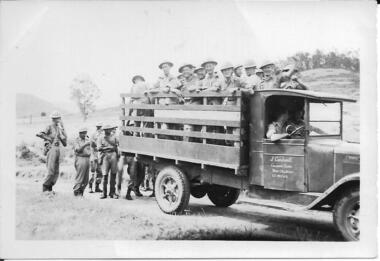
Photograph
Photograph from the collection of Sergeant R. K. Churches, service number VX34599. This photograph is of Australian Army men being transported in an open truck. This is possibly his unit, the 2/9th Field Ambulance, in early World War 2. (refer item number 00320) -
 Flagstaff Hill Maritime Museum and Village
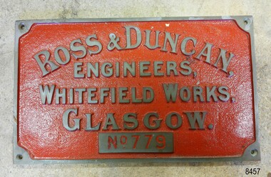
Plaque - Nameplate, ca. 1970s
This nameplate is a reproduction of the Ross & Duncan nameplate and was displayed on the Rowitta vessel activation at Flagstaff Hill. Ross & Duncan of Glasgow manufactured marine engines and boilers from the time it was established in 1860 and growing to employ 450-500 workers by 1911. SS ROWITTA: - The 1909 steam ferry, SS Rowitta, was installed as an exhibit at Flagstaff Hill in 1975 and was enjoyed by many visitors for 40 years. Rowitta was a timber steam ferry built in Hobart in 1909 using planks of Huon and Karri wood. It was a favourite of sightseeing passengers along Tasmania’s Tamar and Derwent rivers for 30 years. Rowitta was also known as Tarkarri and Sorrento and had worked as a coastal trading vessel between Devonport and Melbourne, and Melbourne Queenscliff and Sorrento. In 1974 Rowitta was purchased by Flagstaff Hilt to convert into a representation of the Speculant, a historic and locally significant sailing ship listed on the Victorian Heritage Database. (The Speculant was built in Scotland in 1895 and traded timber between the United Kingdom and Russia. Warrnambool’s P J McGennan & Co. then bought the vessel to trade pine timber from New Zealand to Victorian ports and cargo to Melbourne. It was the largest ship registered with Warrnambool as her home port, playing a key role in the early 1900s in the Port of Warrnambool. In 1911, on her way to Melbourne, it was wrecked near Cape Otway. None of the nine crew lost their lives.) The promised funds for converting Rowitta into the Speculant were no longer available, so it was restored back to its original configuration. The vessel represented the importance of coastal traders to transport, trade and communication in Australia times before rail and motor vehicles. Sadly, in 2015 the time had come to demolish the Rowitta due to her excessive deterioration and the high cost of ongoing repairs. The vessel had given over 100 years of service and pleasure to those who knew her. The nameplate was reproduced to represent the Glasow marine engineers and boilermakers, Ross & Duncan, that were the makers of the engine for the exhibition steam ferry Rowitta. The Tasmanian-built vessel had a long career in Tasmania and Victoria. The nameplate is significant for its connection with the Rowitta, representing the importance of coastal traders to transport, trade and communication in Australia in conjunction with the new rail and motor vehicles. The nameplate is a record of an exhibit at Flagstaff Hill Maritime Village from its early beginnings. Maker's brass nameplate; brass, with embossed text and a hole in each corner. The background is painted red. There are five rows of text; the top row is arranged in an arc. On the bottom row is a number. The nameplate is a replica that was once displayed on the Rowitta vessel at Flagstaff Hill. The reproduction nameplate is for the company Ross & Duncan of Glasgow."ROSS & DUNCAN / ENGINEERS / WHITEFIELD WORKS GLASGOW / NO. 779" flagstaff hill, flagstaff hill maritime museum and village, warrnambool, maritime museum, maritime village, great ocean road, shipwreck coast, steamer, steam ferry, ross & duncan, marine engineers, marine boilers, glasgow engineers, whitefield works, reproduction, scotland, steamer engine, rowitta, sorrento, ss rowitta, navigation, marine technology, steam power, hobart, tasmania, devonport, tasmanian-built, ferry, 1909, early 20th century vessel, passenger vessel, tamar trading company, tamar river, launceston, george town, tarkarri, speculant, peter mcgennan, p j mcgennan & co. port phillip ferries pty ltd, melbourne, coastal trader, timber steamer, huon, karri, freighter, supply ship, charter ferry, floating restaurant, prawn boat, lakes entrance -
 Flagstaff Hill Maritime Museum and Village
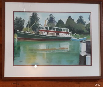
Painting - Maritime painting, Carmel Beavis, The Rowitta, 2012
The artist’s comment on her work: “The Rowitta”, Flagstaff Hill. Warrnambool: "This boat was the venue for our daughter’s Wedding. The pastel work was undertaken after a beautiful day at Flagstaff Hill in 2012. I enjoyed working with the shadows and the foliage. Carmel Beavis” The popular steam ferry Rowitta is featured in this pastel picture on canvas by local artist Carmel Beavis. The iconic Norfolk pines stand tall against a blue sky, while colourful reflections shimmer in Flagstaff Hill’s harbour. The historic lifeboat “Warrnambool” is dwarfed by Rowitta’s size. Carmel’s daughter celebrated her wedding on board the Rowitta, which had been a very popular exhibit visitors for around forty years. This picture is one of several that were created by Carmel for her family and friends as a memento of the wedding and a way to keep the memory of Rowitta alive. Some of Carmel’s other works illustrate Flagstaff Hill’s 2017 publication “Tearooms Cookbook”. Some of Carmel’s paintings featured in the Tearooms Cookbook, produced around 2017 for fundraising for Flagstaff Hill. The Rowitta was a timber steam ferry built in Hobart in 1909 using planks of Huon and Karri wood. She was a favourite of sightseeing passengers along Tasmania’s Tamar and Derwent rivers for 30 years. Rowitta was also known as Tarkarri and Sorrentoand had worked as a coastal trading vessel between Devonport and Melbourne as well as along the southern coast of Australia. In 1974 Rowitta was purchased by Flagstaff Hilt to convert into a representation of the Speculant, a historic and locally significant sailing ship listed on the Victorian Heritage Database. (The Speculant was built in Scotland in 1895 and traded timber between the United Kingdom and Russia. Warrnambool’s P J McGennan & Co. then bought her to trade pine timber from New Zealand to Victorian ports and cargo to Melbourne. She was the largest ship ever registered with Warrnambool as her home port, playing a key role in the early 1900s in the Port of Warrnambool. In 1911, on her way to Melbourne, she was wrecked near Cape Otway. None of the nine crew lost their lives.) The promised funds for converting Rowitta into the Speculant were no longer available, so she was restored back to her original configuration. She represented the importance of coastal traders to transport, trade and communication in Australia times before rail and motor vehicles. Sadly, in 2015 the time had come to demolish the Rowitta due to her excessive deterioration and the high cost of on-going repairs. She had given over 100 years of service and pleasure to those who knew her. Early in 2019 Carmel gifted this picture to her friend Shirley Lindsay, who had been President of Wadas Artist Society. A few months later Shirley and her husband John (founding Director of Flagstaff Hill Maritime Village) thought the picture would be appropriate to Flagstaff Hill and presented it with pleasure to the Friends of Flagstaff Hill group later that year.The Rowitta represents the importance of coastal traders to transport, trade and communication in Australia before rail and motor vehicles. The painting is also significant as a record of an exhibit at Flagstaff Hill Maritime Village from is early beginnings. The painting is locally significant for being connected to a local and well known artist Carmel Beavis.Picture, coloured pastel work on canvas in timber frame behind glass. The artist, Carmel Beavis, depicts the steam boat “Rowitta” moored beside the historic lifeboat “Warrnambool” on the lake at Flagstaff Hill Maritime Village. The Rowitta is reflected in the water. The background includes the iconic Norfolk Pine trees. The work was framed by Warrnambool Picture Framing & Gallery in 2012.Signed on front, bottom left “C.L. Beavis”. Artist’s printed label on reverse “The Rowitta, Flagstaff Hill. Warrnambool: / This boat was the venue for our daughter’s / Wedding. / The pastel work was undertaken after a/ Beautiful day at Flagstaff Hill in 2012. / I enjoyed working with the shadows and / The foliage. / Carmel Beavis / Warrnambool. VIC. 3280. / Telephone (03) 5562 1806. / Price: $” Handwritten on artist’s label “250.00” Framer’s printed label “Warrnambool / Picture Framing / & Gallery / 42 Kepler St, Warrnambool 3280 03 5561 5722 / www.wboolframing.com.au” flagstaff hill, warrnambool, shipwrecked coast, flagstaff hill maritime museum, maritime museum, shipwreck coast, flagstaff hill maritime village, great ocean road, picture, pastel, carmel beavis, rowitta steam boat, warrnambool picture framer & gallery, wedding on the rowitta, the rowitta, tearooms cookbook, hobart steam ferry rowitta 1909, tarkarri, speculant, coastal trading vessel, p j mcgennan & co, peter mcgennan, sorrento -
 Flagstaff Hill Maritime Museum and Village
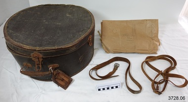
Functional object - Hat box, early to mid-20th century
This large hat box was owned by Miss Katherine Robertson (now deceased). It was sold by Drews, a leather and travel goods shop in Melbourne, and has been made as good quality, sturdy travel luggage. It has its own leather luggage label buckled to the handle and there are remnants of labels on the base of the hat box, signifying that it has indeed been used as luggage. A hat box such as this one is made to protect, store and transport head wear. Hat boxes became popular in the 19th and early 20th century when hats were a part of the modern fashion. Inside the hat box is a brown paper wrapper with two Great Britain postage stamps attached. Both have the portrait image of Queen Elizabeth II (1) orange 1/2d (2) green ten pence. These stamps belong to the Wildings series and were issued 1952-1954. The wrapper was sent by J McGregor in Glasgow, Scotland to Katherine Robertson in Sale, Victoria. The postmark stamp shows it was sent in 1955. The paper had once been folded around something rectangular in shape, perhaps a book. The hat box was recently found by Archie’s daughter, niece of Katherine, when she was looking for something else in the ceiling of her home. The hat box had been there, with the brown paper wrapper inside, for about 30 years, forgotten by the family. There are no family members remaining now to tell the full story. ABOUT MISS KATHERINE ROBERTSON The Robertson family emigrated from the Isle of Wight and settled in Woorndoo, Western Victoria, Australia. Katherine Robinson was the 10th child of 13 children, born in 1906 and lived until 1995. The youngest child in the family was a boy named Archibald (Archie) who was born in 1911. His daughter is the donor of the hat box. Katherine went to school at Woorndoo and later became a trained teacher. She taught in many places, amongst them were Alexandria, Geelong, Sale, Stawell and Ballarat. People said “She was a school teacher 24 hours a day!” She was insistent on being called Miss Katherine Robinson, and no-one dare call her a shortened name in any way, not Kate, or Katie or even Kathie. She spoke with the authority of a teacher throughout her life, never asking but always giving her requests as orders. Miss Katherine Robinson remained single all her life. She bought items that were the best quality and workmanship, which gives reason for the strong and well-travelled hat box. She enjoyed going on trips and travelled the world twice. While on her journeys Katherine would knit Fair Isle patterned socks using fine 4 ply wool because she “Didn’t believe in wasting time!” Katherine’s niece remembers being in Melbourne at Station Pier, seeing her Aunt off on one of her journeys. She recalls the atmosphere and the colourful streamers in the air that celebrated the special occasion. Katherine travelled on the Oriana and Fair Star lines. ABOUT DREWS Drew’s, Leather Goods Specialists, was located at 70 Swanston St, corner of Queen’s Walk, Melbourne, at the time that this hat box was sold by the company. Queen’s Walk was constructed in 1889. It was a lavish ‘L’ shaped arcade that connected Swanston Street to Collins Street and was home to many specialist stores. In the 1950’s Drews address was advertised as Collins Street. In the late 1960’s Queen’s Walk was purchased by the Melbourne City Council and demolished in the early 1970’s, to be replaced by the Melbourne City Square. This very sturdy and good quality hat box is an example of travel luggage available to and used by the Victorian population of Australia in the early to mid-20th century. The retailer of this hat box, Drews, operated from premises on the corner of Swanston St and Queen’s Walk in Melbourne where many other specialist shops were located. Queen’s Walk was only in existence for around 70 years, 1889-late 1960, before it was demolished to make way for Melbourne’s City Square. Hat box, large, deep round shape with a straight section where lid is joined on at the back. Dated early to mid-1900’s. Brown coloured, textured heavy weight card box with folding metal carry handle, three clip closures for lid, metal hinge on back of lid. Purple maker’s label inside lid - DREWS, Leather Goods Specialists, Melbourne. Leather luggage tag has two rectangular cut-outs on front, attached with buckle strap. Underside of lid has two supporting leather straps attached to base. Base has inner cardboard liner around most of circumference. Contained inside are two leather straps with metal buckles. Label remnants, red, attached under base. Hat box was owned by Miss Katherine Robertson. Also inside is brown paper wrapper with three hand written addresses, in blue nib pen, and two attached Great Britain postage stamps, Queen Elizabeth II (1) Orange stamp, QE II, ½d (2) Green stamp, QE II, ten pence. It is postmarked [19] 55. Purple label has printing "70 SWANSTON STREET / Cr. QUEEN'S WALK / DREWS / LEATHER GOODS / SPECIALISTS / MELBOURNE". Wrapper inside has two hand written addresses (1J) Mrs. K. F. Robertson / 33 Mcalister Street / Sale / Victoria / Australia” (2) “from / J Mc Gregor / 15 Napier’s Hall St / Glasgow N W / Scotland” Postmark “ - -em 55” & “CLAS-“ OR “GLAS-“ [GLASGOW] flagstaff hill, warrnambool, shipwrecked coast, flagstaff hill maritime museum, maritime museum, shipwreck coast, flagstaff hill maritime village, great ocean road, luggage, hat box, hatbox, hat storage box, hat travel case, hat case, bandbox, drews melbourne, drew’s melbourne, drew’s handbags, travel goods, travel luggage, hat box suitcase, hat box luggage, 1952-1954 gb postage stamps 1/2d orange queen elizabeth ii, katherine robertson, archibald (archie) robertson of woorndoo, j mcgregor -
 Flagstaff Hill Maritime Museum and Village
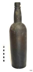
Domestic object - Bottle, 1850's - 1900's
This bottle is sometimes referred to as a black glass 'Gallon' bottle. It is used for storing and transporting liquor such as stout, porter or ale. Glass bottles and glass jars are in many households around the world. The first glass bottles were produced in south-east Asia around 100 B.C. and the Roman Empire around 1 AD. America's glass bottle and glass jar industry were born in the early 1600s when settlers in Jamestown built the first glass-melting furnace. The invention of the automatic glass bottle blowing machine in 1880 industrialized the process of making bottles. In 2019, plans were made to re-introduce milk glass bottle deliveries to Auckland in early 2020. The earliest bottles or vessels were made by ancient man. Ingredients were melted to make glass and then clay forms were dipped into the molten liquid. When the glass cooled off, the clay was chipped out of the inside leaving just the hollow glass vessel. This glass was very thin as the fire was not as hot as modern-day furnaces. The blowpipe was invented around 1 B.C. This allowed molten glass to be gathered at the end of the blowpipe and blown into the other end to create a hollow vessel. Eventually, the use of moulding was introduced, followed by the invention of the semi-automatic machine called the Press and Blow. In 1904 Michael Owens invented the automatic bottle machine. Before this time most glass bottles in England were hand blown. This is one of four bottles in our Collection that were recovered by a local diver from the quarantine area just inside the Port Phillip Heads. Ships were required to pull into this area to check for diseases and other medical issues before they could head up to Melbourne. Quite often they would drink and throw the bottles overboard. Handmade glass bottle, manufactured in the 1850s-1900s. The bottle gives a snapshot into history and a social life that occurred during the early days of Melbourne's development and the sea trade that visited the port in those days. Bottle, glass, solid dark brown (black), round, matt surface. Glass ring below mouth, neck is slightly bulbous, seam line around shoulder, body tapers slightly inward from shoulder to base. Base is concave with pontil mark. Bottle has a white mark down the side. No inscription. Generally used for storing stout, porter or ale.flagstaff hill, warrnambool, shipwrecked coast, flagstaff hill maritime museum, maritime museum, shipwreck coast, flagstaff hill maritime village, great ocean road, handmade bottle, handmade english beer bottle, pontil bottle, black glass, gallon -
 Phillip Island and District Historical Society Inc.
Photograph, 1900's
This postcard is contained in an album presented to the then Governor of Victoria, The Earl of Stradbroke, by the fathers of soldiers & returned soldiers of Phillip Island, on 16/02/1923. The history of the album is noted on Reg. No 85-00Postcard of Beach Road, Cowes, showing stable on site of Continental Hotel, where horse and drags collected passengers to take to Summerland, early 1900's. Moreton Bay Fig planted by Von Mueller.The Rose Series P674. Beach Road Cowes, Phillip Island, Victorialocal history, photography, photographs, slides, film, beach road, cowes, phillip island, the esplanade, transport, moreton bay fig, sepia photograph, beach road cowes -
 Greensborough Historical Society
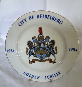
Decorative object - Commemorative Plate, Westminster, City of Heidelberg Golden Jubilee - 1934-1984, 1984
A strictly limited edition produced for the Rotary Club of Heidelberg, Australia' for the celebration of the Golden Jubilee of the City of Heidelberg (now City of Banyule).China plate with gilt edging; wording City of Heidelberg, Golden Jubilee,1934-1984 borders around the plate with the crest placed in the middle. "City of Heidelberg Golden Jubile1934-1984" with Coat of Arms. Underside Rotary International Crest; Fine China, Westminster Australia. The story of: 'Coat of Arms - The carriage wheels and lamp commemorate the early beginnings of the City about 1840 when the Heidelberg Road Trust was the local authority; the wavy band and wattle blossom are symbolic of the River Yarra, whilst the supporters represent the customary mode of transport at the time. The mural crown is the emblem of local government and these perpetuate the distinctive record of the City of Heidelberg in having the first suburban form of local Government of the Colony. An owl, the symbol of wisdom, is also embodied in the crest as our City is named after Heidelberg in Germany whose University founded in AD 1386, became one of the most famous seats of learning. The motto "Industrica" provides a link with the early seal of the City. The municipality was declared a City by Act of Parliament on April 11, 1934.'city of heidelberg, heidelberg, commemorative items, city of banyule -
 Greensborough Historical Society
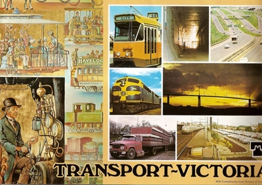
Book, Transport in Victoria, 1980s
Each of these booklets details the history, changes and upgrades to transport in Victoria in the early 1980s and explains the role af government authorities such as the Country Roads Board. Item 707c describes the Melbourne Freight Terminal between Spencer Street and Footscray Road.An historical look at the development of transport in Victoria.A collection of 3 booklets on transport in Victoria. Item 707a: 16 pages, colour illustrations. Item 707b: 20 pages, colour illustrations.Item 707c: 8 pages, black and white illustrations (20 x 14.5 cm). railways, transport, victoria, trams, roads -
 Halls Gap & Grampians Historical Society
Photograph - B/W, C 1932
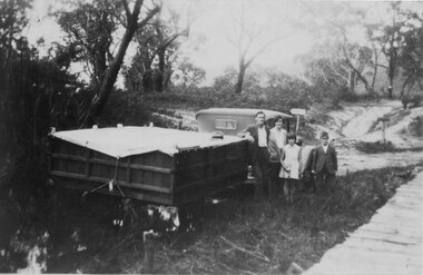
A family on holiday in the Grampians. The deep wagon is an early form of caravan, which folded down and was ready to erect when a site was found. The man is Jack Diamond from Donald.The photo shows a family (a man, a woman, a girl and a boy) standing beside an old car pulling a deep, wooden wagon covered by a tarpaulin. A mans hat sits on the tarpaulin near the man's elbow.The wagon appears to be standing in water and there is a wooden slat surfaced bridge ortrestle to the right. A track with two signposts is in front of the car and there is thin bush in the background.recreation, camping, transport, cars -
 Ararat & District Historical Society (operating the Langi Morgala Museum)
Photograph, Willaura Weighbridge
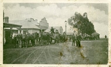
This photograph shows a point in time (late 19C) at the Willaura weighbridge which no longer exists. The weighbridge was part of a transportation system that included horses, wagons, silos, and trains and when this photograph was taken, the weighbridge was crowded with people and wagons. Black and white photograph of a streetscape with wide dirt roads, some early European buildings and three supply wagons. Two are horse drawn and the third is pulled by bullock, with six men driving the wagons and standing in the roadway. Front: "Willaura Weighbridge"willaura, weighbridge, postcard, horses, wagons, wool, transport -
 Kiewa Valley Historical Society
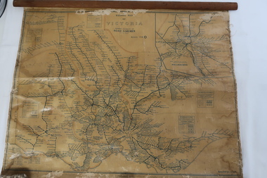
Map - Railway Map of Victoria, Amended to 1/11/1945
Railways began in the 1850s and were privately owned and operated. Later they were taken over by the Victorian Government reaching a peak in the early 1940s.Steam trains were followed by electric trains with both running after the war in 1945.Bright was the closest station to the Kiewa Valley but road transport was used more often as the Kiewa Valley Highway was improved with the construction of the Kiewa Hydro Electric Scheme. To travel to Melbourne or Sydney by train residents went via Wodonga/Albury where they also did their shopping.Plastic on parchment with detailed railway routes (in green) across Victoria including each district's 'Road Foremen' and 'Depots'. There is a length of flat wood attached by 10 tacks across the top of the mapvictorian railways 1945, trains, transport -
 Kiewa Valley Historical Society
Photos: black and white - Working Horses
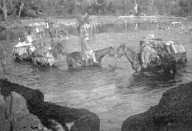
Photo No. 9 Horses Crossing River - Packing in supplies for early workers on the Kiewa Hydro Scheme. There were no roads in the early days of the Scheme. Horses from the Kiewa Valley were used to transport goods prior to roads and vehicles being available1. Horses crossing river - 2 copies 2. Pack horses 3. Rider with pack horse -x2 and See (KVHS 1396) 4. Cattle entering river 5. Horses on High Plains x2 6. color - Horses in River 7. Pack horses and carts 8. 4 Cattlemen with dog in foreground 9. Color - Horses crossing river 10.Horses and tents - Harry Trimble x2working horses, horses from the kiewa valley -
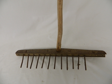 Kiewa Valley Historical Society
Rake - Tea Tree, mid to late 1900's
This "homemade rake" is constructed from a branch of a tea tree. This item demonstrates that in the mid to late 1800's the isolation of the Kiewa Valley was more pronounced than during the early 1900's. The availability of gardening implements to the residences within the Kiewa Valley was scarce to non existence. with the upgrading of roads into the valley and the boost to the Valley's population (S.E.C. Kiewa Valley Hydro Electricity Scheme) transport into the valley, firstly via commercial Hawkers in their mobile caravans and later by commercial trucks. This "home made" rake is very significant because it highlights the ingenuity of local farmers and graziers in overcoming the semi isolation of the Kiewa Valley and its regions from the commercial availability of gardening implements enjoyed by gardeners in the towns and cities of the 1800's and the early 1900's. This "home made" garden rake highlights the ingenuity of the "Australian" character per se. A slice of this ingenuity can be seen by the amount of inventions, per capita, produced within Australia throughout its history.Handle is a long, stripped branch of tea tree. The head of the rake is a 2.3 cm. wide piece of wood, compressed between two 0.5 cm. pieces of metal joined with bolts, nuts and rivets. The holes drilled into the wood hold metal tines 10.5 cms. high. There should be 16 tines but 4 are missing. This type of rake is/ was used in dairiestimber, dairy, farm, rural, implement -
 Warrnambool and District Historical Society Inc.
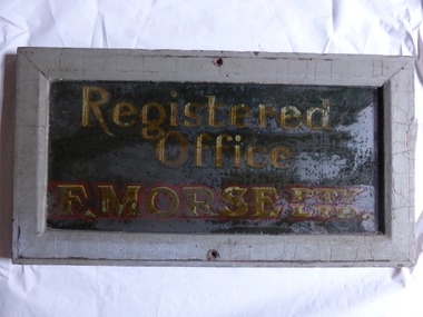
Book, Registered Office E Morse, Early 20th century
This plate comes from the Registered Office of F. Morse Pty Ltd. The name ‘Morse’ has been associated with the local Warrnambool transport industry for more than 100 years from the horse-drawn era to the advent of motorized transport. Frederick Morse was the son of Henry Morse, a teacher at The Grange, Hamilton and at Grasmere in the early 1870s. In 1883 Frederick Morse started business in Fairy Street as a coach builder in a partnership known as Robinson and Morse and in 1891 he set up a business on his own, the Victoria Carriage Works in Lava Street with branches in Port Fairy and Koroit. By the 1890s he was employing 27 people and winning State awards for his Abbot buggies. By the 1920s the Morse business had moved to motorized transport, expanding over the years to car dealerships, caravans, panel works and reconditioning and truck building with the subsidiary businesses of Morsmilk and Morsbearings (both later sold).This plate is of strong significance as a memento of a business in Warrnambool that has been prominent in the local transport industry for 120 years. It is also a memento of the Morse family, notable 19th century settlers in the town and important in local community affairs since that time. This is a wooden frame with a glass front. The frame is painted a grey colour and has holes at the top and bottom for affixing the frame to a wall or door. Behind the glass the words ‘Registered Office F. Morse Pty Ltd’ are painted or incised on to a wooden slab. The words are in yellow and red paint. The frame is a little chipped and the inside of the glass is somewhat blotchy and stained. ‘Registered Office’ ‘F. Morse Pty Ltd’ frederick morse, robinson and morse, morse & co., history of warrnambool, coach building in warrnambool, automotive industry in warrnambool -
 Sir Reginald Ansett Transport Museum
Headwear - Hat, Pillbox, 1969-1972
This hat complements the stewardess uniform designed for Ansett Airlines of Australia between 1969 to 1972. It was donated by Shirley Boles, to Sir Reginald Ansett Transport Museum. Shirley Boles was an air hostess with ANA in the early days of Ansett. Shirley has made a considerable contribution of items to the Sir Reginald Ansett Transport Museum. She was a popular staff member who worked for many years with the company.Beige pillbox hat, with a flat crown and straight, upright sides.Turned up brim, featuring peaked detail on one side. Piped edging. Heavy duty cotton fabric with reinforcing stitches. Fawn grosgrain ribbon interfacing inside. Cream Bem silk lining. Gold coloured badge features 1968-1981 Ansett logo: A Delta" by Nivek Headwear Reg. Melb" on label inside. Red ink numeral 21 & 1/2 handwritten on label. Possibly size 21 inch hat. beige, hostess, 1970's, flight attendants, ansett airlines of australia, stewardess, pillbox, shirley boles, 1969-1972 -
 Sir Reginald Ansett Transport Museum
Headwear - Hat, Pillbox, 1972-1977
Donated to Sir Reginald Ansett Transport Museum by Shirley Boles Ansett Airlines of Australia 1969-1972 Uniform designed for Hostess/Stewardess uniform. Complements the collection of air flight crew attire 1969-1972.Shirley Boles was an air hostess with ANA in the early days of Ansett. Shirley has made a considerable contribution of items to the Sir Reginald Ansett Transport Museum. She was a popular staff member who worked for many years with the company.Beige coloured pillbox hat , with flat crown and straight, upright sides. Turned up brim featuring peaked detail on one side. Piped edging. Heavy-duty poly-cotton (?) fabric with reinforcing stitching. Fawn grosgrain ribbon interfacing inside. Cream bemsilk lining. Gold coloured badge features 1968-1981 Ansett Logo A Delta "by Nivek Headwear Reg. Melb" on label inside. Pencil numeral 20 & 1/2 hand written on label. Commercial Name Tag hand sown Shirley Boles customer service staff, pill-box hat, 1970s, beige, hostess, stewardess, shirley boles, flight attendants, 1969-1972 -
 Sir Reginald Ansett Transport Museum
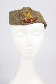
Hat
early (1940s?) hostess cap worn by Airlines of South Australia staffAirlines of South Australia hostess cap without peak. Light & dark olive green plaid pattern. Fine wool (blend?). Oval-shaped crown narrower & lower at front / broader & higher at rear. Olive green bemsilk lining & matching grosgrain sweatband. Matching fabric emblem 7cm high on left front, featuring metallic gold thread embroidery of 3mm thick initials "S" & "A " on crimson background with gold embroidered wings above. No visible evidence of manufacturer or ownersouth australian, hostess cap, wool plaid, gold wire embroidery, olive green -
 Orbost & District Historical Society
black and white photograph, late 19th - early 20th century
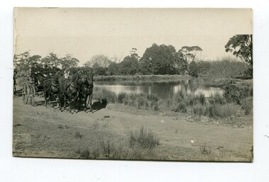
This photograph was taken at the junction of the Snowy and Brodribb Rivers. The Snowy River starts in New South Wales on the slopes of Mt Kosciuszko, Australia’s highest mountain, in New South Wales. It flows into Bass Strait at Marlo in Victoria. The Brodribb River is a tributary of the Snowy which enters the estuary at Marlo. This is a pictorial record of a road in Marlo near Orbost in the late 19th-early 20th centuries. It also depicts the transport used at that time.A black / white photograph of four men in suits seated in a horse - drawn buggy on a dirt road alongside a creek or river. There appears to be another horse - drawn vehicle behind them.on back - "at the Brodribb - Snowy junction. this road was corduroy (packed logs of tea trees?)brodribb-river snowy-river marlo transport-horse-drawn -
 Cheese World Museum
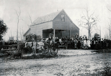
Photograph, Nirranda Creamery
Warrnambool Cheese and Butter Factory at Allansford commenced in 1888. By the early 1900s it had 3 subsidiary creameries where farmers delivered their milk. Often the farmers collected the skim milk to feed pigs. At this time bacon was considered to be a dairy product. There were over 200 butter factories and creameries in Victoria in 1905.This is the only known photograph of the Nirranda Creamery.Black & white photograph showing a two storey weatherboard building with horse and cart loaded with milk cans and a group of men and women standing in front.allansford, nirranda, creameries, transport, costumes, warrnambool cheese and butter factory company -
 Flagstaff Hill Maritime Museum and Village
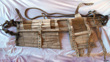
Equipment - Stretcher, 1965 to 1999
A Neil Robinson stretcher is a lightweight carrying device modelled on Japanese bamboo litters, the Neil Robertson rescue stretcher was developed in the early 1900s by John Neil Robertson. Used for lifting an injured person vertically. The stretcher is made from stout canvas reinforced with bamboo slats. The stretcher is designed for removing an injured person from spaces wherein access, doors or hatches are too small to permit the use of regular stretchers. Spaces such as ship engine room spaces, cargo holds, pump rooms, boiler rooms etc. are a few examples of such compact spaces.An item designed to transport injured personnel from tight places, either at sea or on land.A rescue stretcher made from white canvas reinforced with bamboo slats and adjustable canvas straps. The canvas straps are secured with metal buckles and there is a metal ring attached to lengths of ropes at both ends. Noneflagstaff hill, warrnambool, flagstaff hill maritime museum, maritime museum, shipwreck coast, flagstaff hill maritime village, great ocean road, stretcher, neil robertson, neil robertson rescue stretcher, rescue equipment -
 Flagstaff Hill Maritime Museum and Village
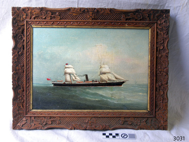
Painting - Vessel, C.K.M. (artist), S.S. Warrnambool, 1883
This oil painting is in a handmade, carved frame, dates back to the period of the old Warrnambool Museum and Art Gallery. The two-masted, sail-and-steam-powered ship has the sails and bow shape of a tall clipper ship plus the extra power of steam. It dates to the transition between the clipper ships with their billowing sails and the steam-powered ships, which happened in the late 19th to early 20th century. The flag flown from the stern is that of the British Merchant Navy that traded around the world to transport cargo, and later passengers, from one destination to another. The painting was originally catalogued as the "S.S. Warrnambool" although it has a different design. It was also attributed to the ship portrait painter, the renowned C.K.M. - Charles Keith Miller - but differs from his style. Further research is being carried out at this time. In 1966, between the closure of the old Warrnambool Museum and Art Gallery and the distribution of the painting to Flagstaff Hill, this painting was repaired by David Heysen, son of the German-born artist Hans Heysen OBE. David was born in Hahndorf (called Ambleside for a short period of time), South Australia, married Lyly Refshauge from Melbourne, and they raised a family on their property in Kalangadoo, near Penola, in South Australia.The painting's frame is an example of handmade carving and joinery created in the late 19th century. The artist has depicted the image of a historical sail-and-steam ship of the type in which cargo was traded across the world, including to and from Australia. Vessels such as this also brought migrants to Australia.Painting, oil on board, in hand carved wooden frame with floral and geometric pattern, inner border painted gold. Image of a two-masted sail and steam ship, sails raised, black funnel emitting smoke. Hull is black with white horizontal stripe and white trim around sides of deck. Three lifeboats are visible. Bow is ‘clipper shape’ with what appears to be a figurehead. A red ensign flag flies at the stern and a blue and red flag is attached to the mainmast. The frame has been assembled using Mortice and Tenon joints, one of which is exposed on the back, lower right corner. Chandelier chain has been attached for hanging. There is no visible signature, date or title on the front of the painting. The back board has empty holes spaced around the edge and is held in place by staples. The visible surface has remnants of adhesive from two rectangular attachment s. There are two small white stickers attached, one with a hand written inscription. There are pencil and pen inscriptions. The painting is protected by cardboard with inscriptions in marking pen.On back board, written in the style used by the Warrnambool Museum and Art Gallery: - On white sticker, in pen “A-P31/1-74” - Pencil “A27/1883 / Artist CKM 1883 / Title SS Warrnambool / oil on board” Written in pen by the repairer - “Repaired & re-drilled – cleaned etc. / David Heysen 11/66” Written by Flagstaff Hill’s Cataloguer - Pencil “3031” On cardboard wrapper, in marking pen: - “S.S. Warrnambool / by / C.K.M. 1883” - “A-P/31/1-74” - “3031”flagstaff hill, warrnambool, shipwrecked coast, maritime museum, shipwreck coast, flagstaff hill maritime village, great ocean road, s s warrnambool, charles keith miller, charles miller, steam and sail ship, british merchant navy, slipper shaped bow, 19th century sea trade, warrnambool museum and art gallery, old warrnambool art gallery, hand carved picture frame, mortice and tennon picture frame, migrants, c.k.m. -
 Flagstaff Hill Maritime Museum and Village
Plaque - Nameplate, Circa 1886
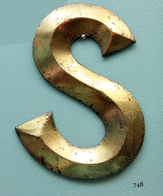
The Falls of Halladale was an iron-hulled, four-masted barque, used as a bulk carrier of general cargo. She left New York in August 1908 bound for Melbourne and Sydney. In her hold was general cargo consisting of roofing tiles, barb wire, stoves, oil, and benzene as well as many other manufactured items. After three months at sea and close to her destination, a navigational error caused the Falls of Halladale to be wrecked on a reef off the Peterborough headland on the 15th of November, 1908. The captain and 29 crew members survived, but her cargo was largely lost, despite two salvage attempts in 1908-09 and 1910. The Court of Marine Inquiry in Melbourne ruled that the foundering of the ship was entirely due to Captain David Wood Thomson's navigational error, not too technical failure of the Clyde-built ship. The Falls of Halladale was built in1886 by Russell & Co., at Greenock shipyards on the River Clyde, Scotland for Wright, Breakenridge & Co of Glasgow. She was one of several designs of Falls Line of ships named after waterfalls in Scotland. The company had been founded between 1870- 1873 as a partnership between Joseph Russell, Anderson Rodger, and William Todd Lithgow. During the period 1882-92 Russell & Co. standardised designs, which sped up their building process so much that they were able to build 271 ships during that time. The Falls of Halladale had a sturdy construction built to carry maximum cargo and able to maintain full sail in heavy gales, one of the last of the 'windjammers' that sailed the Trade Route. She and her sister ship, the Falls of Garry, were the first ships in the world to include fore and aft lifting bridges. Previous to this, heavily loaded vessels could have heavy seas break along the full length of the deck, causing serious injury or even death to those on deck. The new raised catwalk-type decking allowed the crew to move above the deck in stormy conditions. The Falls of Halladale shipwreck is listed on the Victorian Heritage (No. S255). She was one of the last ships to sail the Trade Routes from Europe and the Americas. Also of significance is that the vessel was one of the first ships to have fore and aft lifting bridges as a significant safety feature still in use on modern vessels today. The subject model is an example of an International Cargo Ship used during the 19th and early 20th centuries to transport goods around the world and representing aspects of Victoria’s shipping industry. Nameplate, large brass letter “S” part of the nameplate, recovered from the starboard bow of the wreck of 'Falls of Halladale'. The letter is raised along central axis to form three dimensional effect, and restored to burnished bronze colour.warrnambool, shipwreck coast, flagstaff hill, flagstaff hill maritime village, flagstaff hill maritime museum, shipwreck artefact, great ocean road, brass lettering, falls of halladale, 1908 shipwreck, ship nameplate, letter s, letter, nameplate -
 Flagstaff Hill Maritime Museum and Village
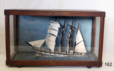
Craft - Ship Model, Falls of Halladale, 1886-1910
The Falls of Halladale was an iron-hulled, four-masted barque, used as a bulk carrier of general cargo. She left New York in August 1908 bound for Melbourne and Sydney. In her hold was general cargo consisting of roofing tiles, barb wire, stoves, oil, and benzene as well as many other manufactured items. After three months at sea and close to her destination, a navigational error caused the Falls of Halladale to be wrecked on a reef off the Peterborough headland on the 15th of November, 1908. The captain and 29 crew members survived, but her cargo was largely lost, despite two salvage attempts in 1908-09 and 1910. The Court of Marine Inquiry in Melbourne ruled that the foundering of the ship was entirely due to Captain David Wood Thomson's navigational error, not too technical failure of the Clyde-built ship. The Falls of Halladale was built in1886 by Russell & Co., at Greenock shipyards on the River Clyde, Scotland for Wright, Breakenridge & Co of Glasgow. She was one of several designs of Falls Line of ships named after waterfalls in Scotland. The company had been founded between 1870- 1873 as a partnership between Joseph Russell, Anderson Rodger, and William Todd Lithgow. During the period 1882-92 Russell & Co. standardised designs, which sped up their building process so much that they were able to build 271 ships during that time. The Falls of Halladale had a sturdy construction built to carry maximum cargo and able to maintain full sail in heavy gales, one of the last of the 'windjammers' that sailed the Trade Route. She and her sister ship, the Falls of Garry, were the first ships in the world to include fore and aft lifting bridges. Previous to this, heavily loaded vessels could have heavy seas break along the full length of the deck, causing serious injury or even death to those on deck. The new, raised catwalk-type decking allowed the crew to move above the deck in stormy conditions. The Falls of Halladale shipwreck is listed on the Victorian Heritage (No. S255). She was one of the last ships to sail the Trade Routes from Europe and the Americas. Also of significance is that the vessel was one of the first ships to have fore and aft lifting bridges as a significant safety feature still in use on modern vessels today. The subject model is an example of an International Cargo Ship used during the 19th and early 20th centuries to transport goods around the world and representing aspects of Victoria’s shipping industry. Ship mode,l Falls of Halladale, four masted ship diorama. Glass case with wood frame. Paper on back of case with inscription "Frank Davey etc" Case frame has title "Falls of Halladale" and date on base of wood frame is" 1908". It was a four-masted iron-hulled barque.On top of case frame "FALLS OF HALLADALE" and on base of case frame "1908". Paper on back of case has inscription "Frank Davey " (See note section this document for details on Frank Davey)flagstaff hill, warrnambool, shipwrecked coast, flagstaff hill maritime museum, flagstaff hill maritime village, great ocean road, shipwreck peterborough vic, ship model, fall of halladale ship, trade winds, barque, trade vessel, wright, breakenridge & co, ricer clyde -
 Flagstaff Hill Maritime Museum and Village
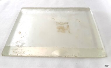
Functional object - Glass Lens, 1886-1908
This glass lens was recovered from the wreck of the Falls of Halladale. Its purpose is unknown but could have been a clock face cover, a lamp or torch lens or even the lens from underwater equipment. The FALLS of HALLADALE 1886 - 1908- The sailing ship Falls of Halladale was an iron-hulled, four-masted barque, used as a bulk carrier of general cargo. She left New York in August 1908 bound for Melbourne and Sydney. In her hold was general cargo consisting of roof tiles, barbed wire, stoves, oil, benzene, and many other manufactured items. After three months at sea and close to her destination, a navigational error caused the Falls of Halladale to be wrecked on a reef off the Peterborough headland on the 15th of November, 1908. The captain and 29 crew members survived, but her cargo was largely lost, despite two salvage attempts in 1908-09 and 1910. The Court of Marine Inquiry in Melbourne ruled that the foundering of the ship was entirely due to Captain David Wood Thomson's navigational error, not too technical failure of the Clyde-built ship. The Falls of Halladale was built in1886 by Russell & Co., at Greenock shipyards on the River Clyde, Scotland for Wright, Breakenridge & Co of Glasgow. The ship had a sturdy construction built to carry maximum cargo and was able to maintain full sail in heavy gales, one of the last of the 'windjammers' that sailed the Trade Route. She and her sister ship, the Falls of Garry, were the first ships in the world to include fore and aft lifting bridges. The new raised catwalk-type decking allowed the crew to move above the deck in stormy conditions. This glass lens is significant for its association with the wreck of the sailing ship the Falls of Halladale. The Falls of Halladale shipwreck is listed on the Victorian Heritage (No. S255). She was one of the last ships to sail the Trade Routes from Europe and the Americas. Also of significance is that the vessel was one of the first ships to have fore and aft lifting bridges as a significant safety feature still in use on modern vessels today. The subject model is an example of an International Cargo Ship used during the 19th and early 20th centuries to transport goods around the world and represents aspects of Victoria’s shipping industry. Glass lens; transparent glass rectangle with bevelled edges. It was recovered from the wreck of the Falls of Halladale. flagstaff hill, warrnambool, flagstaff hill maritime museum and village, shipwreck coast, great ocean road, shipwreck artefact, falls of halladale, glass lens, rectangular lens, glass cover -
 Flagstaff Hill Maritime Museum and Village
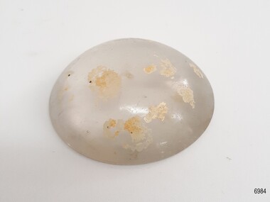
Functional object - Glass Lens, 1886-1908
This glass lens was recovered from the wreck of the Falls of Halladale. Its purpose is unknown but could have been a lamp or torch lens or even the lens from underwater equipment. The FALLS of HALLADALE 1886 - 1908- The sailing ship Falls of Halladale was an iron-hulled, four-masted barque, used as a bulk carrier of general cargo. She left New York in August 1908 bound for Melbourne and Sydney. In her hold was general cargo consisting of roof tiles, barbed wire, stoves, oil, benzene, and many other manufactured items. After three months at sea and close to her destination, a navigational error caused the Falls of Halladale to be wrecked on a reef off the Peterborough headland on the 15th of November, 1908. The captain and 29 crew members survived, but her cargo was largely lost, despite two salvage attempts in 1908-09 and 1910. The Court of Marine Inquiry in Melbourne ruled that the foundering of the ship was entirely due to Captain David Wood Thomson's navigational error, not too technical failure of the Clyde-built ship. The Falls of Halladale was built in1886 by Russell & Co., at Greenock shipyards on the River Clyde, Scotland for Wright, Breakenridge & Co of Glasgow. The ship had a sturdy construction built to carry maximum cargo and was able to maintain full sail in heavy gales, one of the last of the 'windjammers' that sailed the Trade Route. She and her sister ship, the Falls of Garry, were the first ships in the world to include fore and aft lifting bridges. The new raised catwalk-type decking allowed the crew to move above the deck in stormy conditions. This glass lens is significant for its association with the wreck of the sailing ship the Falls of Halladale. The Falls of Halladale shipwreck is listed on the Victorian Heritage (No. S255). She was one of the last ships to sail the Trade Routes from Europe and the Americas. Also of significance is that the vessel was one of the first ships to have fore and aft lifting bridges as a significant safety feature still in use on modern vessels today. The subject model is an example of an International Cargo Ship used during the 19th and early 20th centuries to transport goods around the world and represents aspects of Victoria’s shipping industry. Glass lens; transparent glass dome with flat base. Glass has bubbles and several concentric lines on the surface. There are light coloured encrustations on the surface. It was recovered from the wreck of the Falls of Halladale. flagstaff hill, warrnambool, flagstaff hill maritime museum and village, shipwreck coast, great ocean road, shipwreck artefact, falls of halladale, glass lens, glass cover, glass dome