Showing 169 items
matching early sunbury
-
 Hume City Civic Collection
Photograph
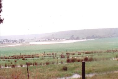
... heavy rain had fallen in Sunbury in the early 1990s. The Jackson... heavy rain had fallen in Sunbury in the early 1990s. The Jackson ...The series of photographs were taken after exceptional heavy rain had fallen in Sunbury in the early 1990s. The Jackson Creek overflowed its banks and the surrounding flood plain area was under water.A coloured photograph of the Jackson Creek in flood along a river flat within the Rupertswood Estate. There are bare hills in the background and a fenced off run in the foreground.floods, weather patterns, jacksons creek, george evans collection -
 Hume City Civic Collection
Photograph
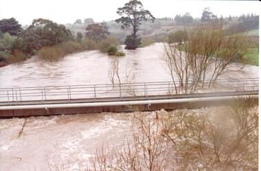
... heavy rain had fallen in Sunbury in the early 1990s. Jackson's... heavy rain had fallen in Sunbury in the early 1990s. Jackson's ...The series of photographs were taken after exceptional heavy rain had fallen in Sunbury in the early 1990s. Jackson's Creek overflowed its banks and the surrounding flood plain area was under water.A coloured photograph of Jackson's Creek in flood taken near the footbridge in Macedon Street. The Nook area and Goonawarra Vineyard are in the background.floods, weather patterns, jacksons creek, george evans collection -
 Hume City Civic Collection
Photograph
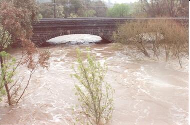
... heavy rain had fallen in Sunbury in the early 1990s. Jackson's... heavy rain had fallen in Sunbury in the early 1990s. Jackson's ...The series of photographs were taken after exceptional heavy rain had fallen in Sunbury in the early 1990s. Jackson's Creek overflowed its banks and the surrounding flood plain area was under water.A coloured photograph of Jackson's Creek in flood. The floodwaters have almost reached the top of the arch of the Macedon Street stone bridge.floods, weather patterns, jacksons creek, george evans collection -
 Hume City Civic Collection
Photograph, late 1980s
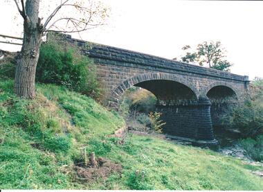
The road bridge over Jackson's Creek in Sunbury was built in 1870 and was in use until a wider bridge was built when Sunbury Road was rebuilt in the early 1970s.A coloured photograph taken from the NE side of the river bank of a complete view of the bluestone bridge at Macedon Street. The two eliptical arches and the protruding pylon as well as the underside of the bluestone span are clearly visible.transport, roads and bridges, jacksons creek, harris, thomas lascelles, george evans collection -
 Hume City Civic Collection
Photograph, late 1980s
This is a photograph of the site and the remains of the Lochton flour mill which was situated on a horse shoe bend along Deep Creek at Bulla. Captain William Morrison Hunter took up land along Deep Creek and built his home in 1850.He opened the flour mill in 1856, which was worked by a number of millers until it ceased operations in 1961.Flour milling was one of the early industries carried out in the Sunbury and Bulla district. The mills were established along Jacksons Creek in Sunbury and Deep Creek in Bulla.A coloured photograph of a tree lined horseshoe bend in a river with the remains of a bluestone building in the bottom RH corner.lochton flour mill, bulla, flour mills, captain william morrison hunter -
 Hume City Civic Collection
Photograph, late 1990s
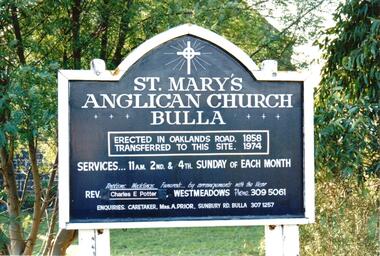
St. Mary's Anglican Church at Bulla was originally built on the outskirts of Bulla township in 1858. In the early 1970s it was moved to its present site to make way for the flight path at the newly constructed Tullamarine Airport. The former site was on the corner of Oaklands and Sunbury Roads and is covered with vegetation. The church was designed by Thomas Taylor.A coloured photograph of the board which is along the fence line outside St. Mary's Church at Bulla. The white writing is on a navy blue background and is framed in white. The notice gives details of services, clergy and caretaker.churches, religion, anglican church, taylor, thomas, potter, charles e. rev., prior, a., st. mary's anglican church, george evans collection -
 Hume City Civic Collection
Photograph, late 1990s
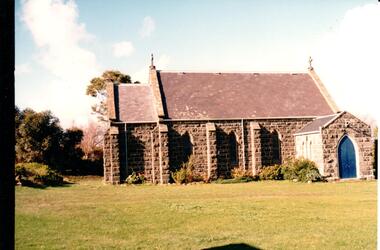
St. Mary's Anglican Church at Bulla was originally built on the outskirts of Bulla township in 1858. In the early 1970s it was moved to its present site to make way for the flight path at the newly constructed Tullamarine Airport. The former site was on the corner of Oaklands and Sunbury Roads and is covered with vegetation. The church was designed by Thomas Taylor.A profile view of the west side of St. Mary's Anglican Church at Bulla and the garden area around the church. A slate covered gable roof has been constructed over the porch nave and chancery with a cross at each end of the roof over the nave. 6 bluestone buttresses and 3 lance windows are along the side with 3 small lancet windows and a blue painted wooden lancet door on the porch.churches, religion, taylor, thomas, st. mary's anglican church, george evans collection -
 Hume City Civic Collection
Photograph, early 1990s
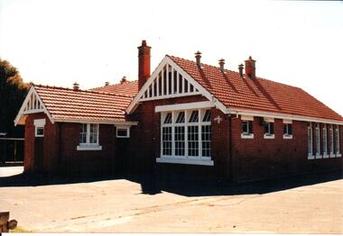
The brick building was constructed in 1911/1912 and replaced an earlier school building. In 1942/43 the school building was extended to cope with the increased population in Sunbury. The State School remained on the Macedon Street site until 1999 when it was relocated to the restored former Industrial School at Jacksons Hill.A coloured photograph of the former Sunbury State School No. 1002. It is a red brick Federation building with a red terracotta tiled roof and wooden white painted trims. There are two stepped brick chimneys with terracotta chimney pots and six air vents protruding from the roof. There is a small porch at the front of the building.carirns, j. f. dr., eadie, peter, education department, george evans collection -
 Hume City Civic Collection
Photograph, 1990s
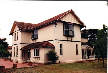
The double storey Federation style house was built in 1911 for Dr. William Cooke Faulkner who was the local doctor until his death in 1922. It was then bought by the local state school headmaster, John James Rogers, for over 6,500 pounds. In the early 1940s a grazier, Eric George Whiteside, bought the property. Bill Landeryou, MLC lived in the house until the late 1980s. He had purchased it from the Campbell family.A coloured photograph of 'Arcloney' a Federation style house with a red terracotta gable roof and cream rendered walls. The wooden frames around the windows have been painted dark green and cream. There is a glassed conservatory to the rear of the building.arcloney, faulkner, william cooke, dr., rogers, john james, whiteside, eric george, landeryou, bill mlc, george evans collection -
 Hume City Civic Collection
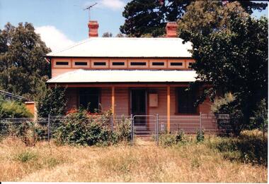
Photograph, early 1990s
The weatherboard house is one of the six weatherboard cottages which were built on the east side of O'Shanassy Street in the early 1900s. It has been listed in the Heritage Study in 1998. Scheduled as having some significance and recommended for further investigation.A coloured photograph of a weatherboard Victorian cottage with an overhanging verandah across the double fronted building. The weatherboard walls are painted biscuit and the window and door frames are tan. A wooden tile trim painted in biscuit, tan and dark green. There are two stepped chimneys protruding from the white painted corrugated iron roof. The overgrown garden has low growing trees and shrubs.george evans collection -
 Hume City Civic Collection
Photograph, early 1990s
The series of 5 photographs feature different views of the Woodlands Housing Development which opened up land bounded by Gap and Anderson Roads, Cornish Street and Elizabeth Drive in the early 1990s. It was a large housing development built close to Sunbury township.A coloured photograph of one of the last housing developments which took place in the old township area. It is a photograph taken at the north end of Anderson Road looking towards Gap Road. One house has been built and there are a number of 'For Sale' signs of blocks fronting Anderson Road. Guttering and driveways have been formed on one side of the road.housing developments, anderson road, george evans collection -
 Hume City Civic Collection
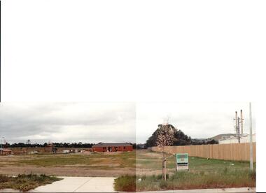
Photograph, early 1990s
The series of 5 photographs feature different views of the Woodlands housing development which opened up land bounded by Gap and Anderson Roads, Cornish Street and Elizabeth Drive in the early 1990s. It was a large housing development built close to Sunbury township.A view of the northern boundary of the Woodlands housing development in Anderson Road. A paling fence divides the estate from the 'Malley' factory, now 'Storage King' which is on the corner of Cornish Street and Anderson Road. A 'For Sale' sign is in the foreground and a partly built house is in the middle distance.housing developments, anderson road, george evans collection -
 Hume City Civic Collection
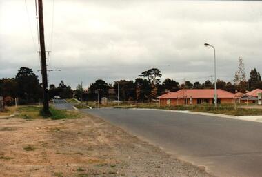
Photograph, early 1990s
The series of 5 photographs feature different views of the Woodlands housing development which opened up land bounded by Gap and Anderson Roads, Cornish Street and Elizabeth Drive in the early 1990s. It was a large housing development built close to Sunbury township.A coloured photograph of a new housing development taken in Anderson Road looking west towards Elizabeth Drive and the leisure centre. Some housing construction is in the middle distance.housing developments, anderson road, george evans collection -
 Hume City Civic Collection
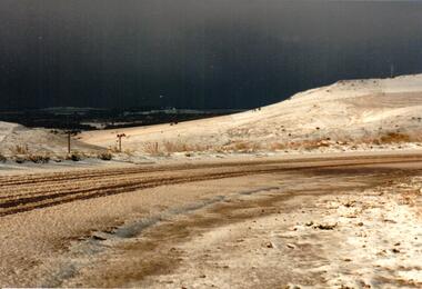
Photograph, 1/08/1986
A series of photographs were taken when heavy snow fell in Sunbury in August 1986. The snow began falling overnight and remained on the ground for 24 hours. Snow fell across the metropolitan area during that 24 hour period in a very unusual event for the area.A coloured photograph taken in the early morning after snow had fallen. The surrounding countryside around Mt. Holden is snow covered.snow falls, weather patterns, winter, mt. holden (mt. lion), george evans collection -
 Hume City Civic Collection
Photograph, early 1980s
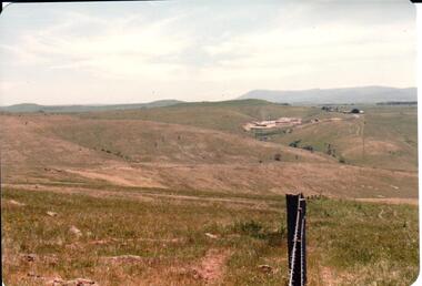
The Sunbury Tip was transferred from the end of Reservoir Road as housing development spread in that area to a site on the NW side of Mt. Holden near Riddell Road in the early 1980s.A landscape coloured photograph with rounded corners. It is a panoramic view of open country NW of Sunbury near Riddell Road. There is a fence post with barbed wire hanging from it in the immediate foreground and Macedon Ranges and part of the Western Highlands can be seen across the skyline.macedon ranges, mt. macedon, camel's hump, sunbury municipal tip, george evans collection -
 Hume City Civic Collection
Photograph, early 1980s
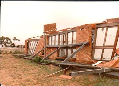
The photograph was taken after a severe wind storm which occured in the Bulla-Oaklands area in the early 1980s, possibly near Christmas Eve.A coloured photograph with rounded corners. It is a panoramic view of a partly built brick veneer house which has been damaged as a result of a wind storm. Across the front are three sets of large full length windows. There is a horse training run in the background.george evans collection -
 Hume City Civic Collection
Photograph, early 1980s
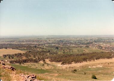
The photograph shows the extent of Sunbury's development to the west of the town in the early 1980s. The settlement at this stage extended along either side of Gap Road for about 0.5 km beyond Elizabeth Drive.A coloured landscape photograph with rounded corners taken from Mt. Holden and looking towards the expanding town of Sunbury. The Melba Avenue drain which flows into Blind Creek is in the foreground. Sheoak Hill, the site of the former Sunbury Asylum is in the middle of the skyline.sunbury township, reservoir road, mt. holden, sunbury asylum, george evans collection -
 Hume City Civic Collection
Photograph, early 1980s
The Headland Estate housing development began in the early 1980s. It was situated west of Sunbury and was bounded by Elizabeth Drive, Reservoir Road, Phillip Drive and Stewart's Lane.A coloured landscape photograph with rounded corners of a view of Sunbury overlooking the Headland Estate before its development. There is a rocky outcrop on the LHS of the photograph and a lightly timbered area in the middle distance. Sunbury can be seen in the distance.headland estate, mt. holden, sunbury township, george evans collection -
 Hume City Civic Collection
Photograph, 1/12/1982
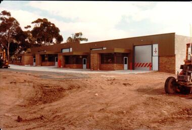
The railway land between Horne Street and the railway line was developed for commercial and industrial purposes during the late 1970s and early 1980s. The former Shire of Bulla developed much of this area and leased the space to private companies.A coloured photograph with rounded corners of 4 brick factory units. There is a large digger on the RHS. The area in front of the units has been paved but the remaining area is unsealed.factories, industrial estates, shire of bulla, george evans collection -
 Hume City Civic Collection
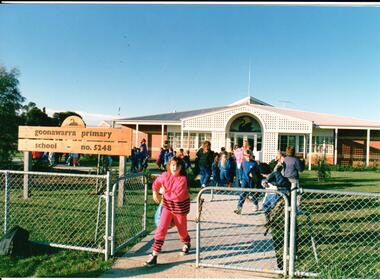
Photograph, early 1980s
Goonawarra Primary School was opened in the early 1980s to accommodate children who were living in the Goonawarra Housing Estate. Prior to development this area was known as Goonawarra Farm and John McMahon grazed his dairy cattle on the land.A coloured photograph of the Goonawarra Primary School and main gate with school children leaving the grounds. A girl dressed in a pink tracksuit is at the gate.state education, schools, goonawarra primary school, goonawarra housing estate, goonawarra farm, ministry of education, george evans collection -
 Hume City Civic Collection
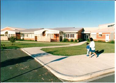
Photograph, early 1980s
Goonawarra Primary School was opened in the early 1980s to accommodate children who were living in the Goonawarra Housing Estate. Prior to development this area was known as Goonawarra Farm and John McMahon grazed his dairy cattle on the land.A coloured photograph of the recently completed Goonawarra Primary School. A lady and little boy are walking along the footpath in front of the building. There is an expanse of lawn between the path and the building.state education, schools, goonawarra primary school, goonawarra housing estate, goonawarra farm, ministry of education, george evans collection -
 Hume City Civic Collection
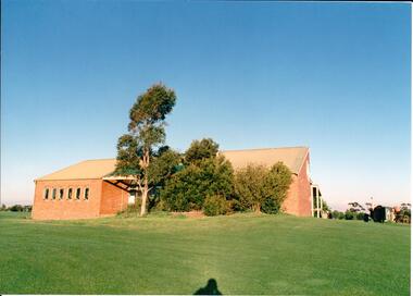
Photograph, early 1980s
The series of photographs were taken shortly after the opening of the newly established Goonawarra Golf Club in the early 1980s. The golf club was part of the Goonawarra Housing Estate which was developed on the area previously known as Goonawarra Farm. The new golf club replaced 'The Pines' which was part of the Caloola complex.A coloured photograph of the rear of Goonawarra Golf Club's Clubrooms. Along the wall of a small vestibule are 6 narrow casement windows. A native garden is planted along the building with a large grassy area extending downhill from the building.goona warra golf club, george evans collection -
 Hume City Civic Collection
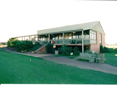
Photograph, early 1980s
The series of photographs were taken shortly after the opening of the newly established Goona Warra Golf Club in the early 1980s. The golf club was part of the Goonawarra Housing Estate which was developed on the area previously known as Goonawarra Farm. The new golf club replaced 'The Pines' which was part of the Caloola complex.A coloured photograph of the front view of Goonawarra Golf Club's clubrooms. The building is on 2 levels with a large balcony across the front. Native plants have been planted around the building and a gravel path leads to the building.goona warra golf club, george evans collection -
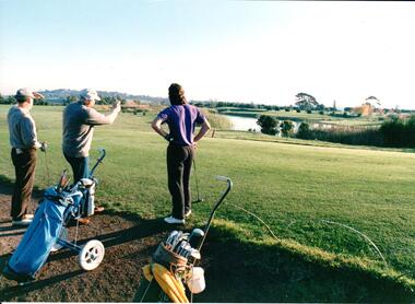 Hume City Civic Collection
Photograph, early 1980s
The series of photographs were taken shortly after the opening of the newly established Goona Warra Golf Club in the early 1980s. The golf club was part of the Goonawarra Housing Estate which was developed on the area previously known as Goonawarra Farm. The new golf club replaced 'The Pines' which was part of the Caloola complex.A coloured photograph of 3 men who are looking towards the lake at the Goonawarra Golf Club. Their golf buggies are behind them.goona warra golf club, george evans collection -
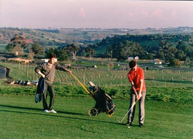 Hume City Civic Collection
Photograph, early 1980s
The series of photographs were taken shortly after the opening of the newly established Goona Warra Golf Club in the early 1980s. The golf club was part of the Goonawarra Housing Estate which was developed on the area previously known as Goonawarra Farm. The new golf club replaced 'The Pines' which was part of the Caloola complex.A coloured photograph of two golfers. One is preparing to hit off while the other is standing in the background with the golf buggy. They are standing overlooking the Goonawarra and Craiglea vineyards and the Jacksons Creek valley.goona warra golf club, george evans collection -
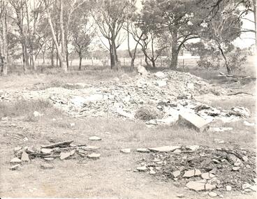 Hume City Civic Collection
Photograph, late 1960s
In the late 1960s St. Mary's Anglican Church was dismantled from its Oaklands Road site and rebuilt on land in Bulla township adjacent to the old shire offices. It was moved because of the interference it would create for aircraft landing in the new Melbourne Airport at Tullamarine. The site has been left timbered because some of the district's early settlers were buried in the church yard before the Bulla Cemetery was established.A black and white photograph of the site of the former St. Mary's Anglican Church at Oaklands Road. There are heaps of building rubble in the foreground and trees in the background.st. mary's anglican church - bulla, oaklands road, graveyards, george evans collection -
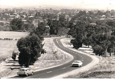 Hume City Civic Collection
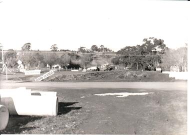
Photograph, Early 1970s
... melbourne In the early 1970s the eastern approach to Sunbury ...In the early 1970s the eastern approach to Sunbury was changed. The stone bridge spanning the Jacksons Creek was replaced by a wider concrete structure and dangerous curves were taken out of the road. The area on the LHS of the photograph including the two arched stone bridge has been incorporated into a public picnic area.A black and white panoramic view of the eastern approach to Sunbury and the Sunbury township before the road was widened and straightened and the new bridge was built. There are two cars in the foreground. One is approaching the bridge and the other is leaving Sunbury.macedon street, macedon street road bridge, jacksons creek, sunbury township, george evans collection -
 Hume City Civic Collection
Photograph, Early 1970s
The two arch bluestone bridge which spanned the Jacksons Creek was replaced in the early 1970s with a wider double lane bridge. Dangerous curves were also taken out of the road. The area in the foreground on the RHS has now been incorporated into a public picnic area.A black and white photograph of road works taking place on the Sunbury Road over Jacksons Creek. Large concrete drain pipes are in the foreground and on the RHS of the photograph with roadwork signs on the LHS. Three trucks are at the foot of the hill.macedon street, macedon street road bridge, jacksons creek, road construction, george evans collection -
 Hume City Civic Collection
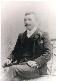
Photograph
The Eadie family were early settlers and entrepreneurs in Sunbury. The family properties in the town included Ben Eadie and Dunblane.A black and white photograph of a young man sitting on a bamboo and wicker chair. He has a moustache and is wearing a dark suit with a white shirt and bow tie and a spray of flowers in his lapel.eadie, peter (jnr), ben eadie, dunblane, george evans collection -
 Hume City Civic Collection
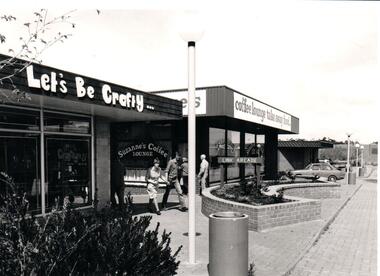
Photograph
... melbourne In the early 1980s, the CBD of Sunbury bounded by Evans ...In the early 1980s, the CBD of Sunbury bounded by Evans, Brook, O'Shanassy and Station Streets underwent major redevelopment. The photograph was taken in the centre of this developed area.A black and white photograph of a small shopping complex showing a craft shop and a coffee lounge. Five people are at the entrance of the small arcade.shopping centres, bakery walk, link arcade, let's be crafty, suzanne's coffee lounge, george evans collection