Showing 90 items
matching elizabeth russell
-
 Eltham District Historical Society Inc
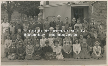
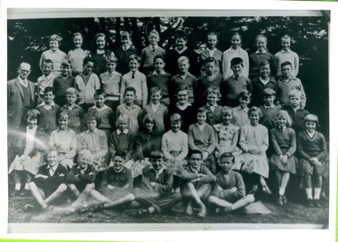
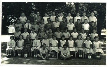
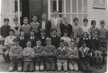
Photograph - Digital Copy, George Murray, Eltham State School, Grade 2, 1958
Back Row (L-R): Russell Smart, John Mead, Peter Norman, Kim Hunter, Richard Lynch, Stephen Short, Gilbert McGloughlin, Don Muir, Jeff Steele, Geoffrey Thorpe, Ian Murray, Marcus Skipper, Ray ( ? ), Robert Spencer Third Row (L-R): Bruce Martin, Neville Myers, Nelson (Smart?), George Sutherland, Robert Dowdell, David Campbell, Ken Dickerson, Kit Hill, Wayne Brodford, Martin Fowler, Michael Kilpatrick, Colin Graham, Ken Brown, David Boss, Greg Lewis Second Row (L-R): Bora Meredith, Heather Dyke, Linda Morris, Janne Miles, Biddy Quinlan, Cheryl Croft, Terry Croft, Margaret Box, Shelley Barker, Wendy Bradley, Sandra Black, Lynette Pitcher Front Row (L-R): Sally Lewis, Faye Harris, Elizabeth Jolley, Wendy Rainsbury, Helen Corrie, Bronwen Cavistock, June Skippington, Gloria Oldfield, Anna Jacka, Ruth GangellNames written on reverse and photographer's stamp1958, anna jacka, biddy quinlan, bora meredith, bronwen cavistock, bruce martin, cheryl croft, class photo, colin graham, david boss, david campbell, don muir, elizabeth jolley, eltham state school no. 209, faye harris, faye walker (nee harris) collection, geoffrey thorpe, george sutherland, gilbert mcgloughlin, gloria oldfield, grade 2, greg lewis, heather dyke, helen corrie, ian murray, janne miles, jeff steele, john mead, june skippington, ken brown, ken dickerson, kim hunter, kit hill, linda morris, lynette pitcher, marcus skipper, margaret box, martin fowler, michael kilpatrick, nelson smart, neville myers, peter norman, richard lynch, robert dowdell, robert spencer, russell smart, ruth gangell, sally lewis, sandra black, shelley barker, stephen short, terry croft, wayne brodford, wendy bradley, wendy rainsbury -
 Glen Eira Historical Society
Photograph - Mayor Jack Campbell 1986-87 (2 of 2)
52 colour photographs of the Mayoress’ receptioncouncillor, mayor, mayoress, jack campbell, felicitie campbell, doug aylen, mayoress of melbourne, nancy needham, elizabeth loftus, yvonne walters, norma doolan, alma arden, molly sinclair, adda gun, joyce bunny, mrs pullman, jessie green, mrs stillwell, russell mcgregor, sadie brown, betty simms, winifred ?, robin ford, dorothy ford, hannah mcgregor, joyce bunny -
 Eltham District Historical Society Inc
Slide - Photograph, Benchmark, Susie Kumar & Naomi Kumar (1997), Conventry Oval, Elizabeth Street, Diamond Creek, c.Nov. 2001
Part of a slide show presentation "A Trip Down the Diamond Creek" by Russell Yeoman to the Eltham District Historical Society meeting of 14 Nov. 200135mm colour positive transparency Mount - Black and Whiteart in public places, benchmark, conventry oval, diamond creek, elizabeth street, naomi kumar, public art, susie kumar -
 Bendigo Military Museum
Administrative record - COMPENDIUM WW1 - WW2, 4) A H Pettifer, Government Printer et al, 2) 14.2.1946; .3) 1.3.1919; .4) 30.11.1954 .5) 24.11.19? - WWI; .6) 31.10.1917; .7) 12.6.1917; .8) Page 1: 20.12.1915, Page 2: 10.12.1915, Page 6: 19.1915; .9) 10.9.1918; .10) 18.4.1919; .11) c.2.3.19?; .12) 18.9.1920; .14) post WWI; .15) 24.4.1920; .17) 18.4.1942; .18) 19.6.1943; .19) 18.3.1947; .20) 1944; .21) 1944; .23) 22.10.1941; .26) 13.9.1944; .27) 1.1944; .30) 7.3.1950; .31) 31.7.1944; .32) 16.4.1942; .33) 13.6.1946; .34) 6.5.1946; .36) a) & b) 3.11.1947; .37) 24.10.1951; .38) 24.9.1957; .39) 9.10.1957; .40) 19.2.1958; .41) 26.2.1958; .42) 1.3.1958; .43) & .44) 7.3.1958; .45) 25.2.1958; .46) 3.1.1948; .47) 26.2.1948; .48) 22.4.1958; .49) 24.2.1958; .50) 12.3.1958; .51) 6.1958; .52) c.Mar/Apr 1958; .53) 5.4.1958; .54) c.end WWII; .55) a.b. 13.6.1967; .56) 26.5.1967; .57) 18.2.1954
Herbert Trangmar Allan, refer 2755.4 for his extensive service history and wards. .2) Details gifting of a pair of Japanese binoculars to Col H T ALLAN by Pacific Island Regiment. .3) Certificate issued by Winston Churchill, Secretary of State for War (The War of 1914-1918), awarded to Capt H T ALLAN MC. .4) Herbert Trangman ALLAN born 5.1.1895 at Woolwich, NSW. Middle name misspelled, should be Trangmar not Trangman. .6) Congratulating H T ALLAN on receiving the Military Cross award for leading 2 companies which had lost officers during action on Passchendaele Ridge on 9.10.1917. .7) Describes life behind the lines whilst H T ALLAN's battalion has been resting for a month. Daily life consisted of training drills, sport & entertainment. Writer takes time to describe the countryside & weather. .8) Relate to H T ALLAN's military exam results & his promotion to 2nd Lieutenant in 1915. .9) To Herbert Allan's father, Mr P Allan detailing the citation for awarding of the Military Cross to Herbert ALLAN. Original citation appeared in the London Gazette,5.4.1918. .10) Form addressed to Capt H ALLAN MC, 17th Battalion stating his period of enlistment in the 1st AIF was to expire 26.5.1919. .11) Letter from Lord BIRDWOOD (General) to Herbert ALLAN in response to a letter received 19.11.19?. General BIRDWOOD expresses his opinions on difficulties the allied troops face in their fight against the Japanese. .12) Letter to Capt H T ALLAN advising of MID oak leaves sent to him. Details guidelines for attaching oak leaves to both the larger Victory Medal & the small service dress medal. .13) Form details H T ALLAN's WWII Army No, Rank, Unit & Decorations & Medals held. The form has not been signed & dated. .14) Details service record of Lt Col H T ALLAN NX12229. Includes military service from 1912 - 1944, schools & courses attended, decorations, promotions & overseas service. .16) Form issued to H T ALLAN on 15.12.1939 granting permission to leave New Guinea for Australia & return within a period of 12 months. Issued by Customs Office in Salamaua. Lists H T ALLAN's age as 44, height 5' 10" & occupation. .17) Letter from Major General MORSHEAD GOC, AIF (ME) to Major H T ALLAN, OBE, MC congratulating him on being awarded the OBE for outstanding service at Tobruch. .18) Letter from Major General MORSHEAD to Major H T ALLAN, OBE, MC replying to ALLAN's letter of 15.6.1943. MORSHEAD is congratulating ALLAN on his appointment to New Guinea Force, also acknowledges his excellent service record. .19) Letter acknowledges H T ALLAN's resignation from the Office of Production Member of the Australian New Guinea Production Control Board, effective from 28.8.1946. .20) Major General WINDEYER commanded the 20th Brigade from 1942-1946. .22) Card sent from the CO of the 3rd Australian Anti-Tank Regiment. .23) Menu for Farewell Dinner held in the Officer's Mess of the 20th Infantry Brigade, Tobruch on 22.10.1941. .24) Menu & Toast list for Farewell Dinner to Brigadier J J MURRAY DSO MC VD. Attended by H T ALLAN & held in the Officers Mess, 2/17 Australian Infantry Battalion on 22.12.1941. .25) Invitation to Col H T ALLAN by Lady Gowrie (wife of Governor General Baron Gowrie) to attend a Luncheon at Government House, Canberra, ACT. .26) Letter to Major (T/Lt Col) H T ALLAN from Major W A JENNER advising him of his secondment to 2/17 Australian Infantry Battalion & appointment to command 5 Aust Base Sub Area. .27) Application for Africa Star with Eighth Army Clasp signed by H T ALLAN & approved by Lt Colonel of 2/17 Australian Infantry Battalion. H T ALLAN held the rank of Major (substantive) at the time of qualification, 1.3.1942 - 11.1942. He held the rank of Lt Colonel at the time of application in 2.1944. .28) Detailing changes in command & promotions including that of Lt Col H T ALLAN, dated 1.4.19? .29) For Lt Col H T ALLAN detailing movements required by First Australian Army command. .30) Acknowledgement & confirmation of Col H T ALLAN's application for campaign awards for WWII. .31) Letter addressed to Lt Col H T ALLAN from Lt Gen Stanley Sauige requesting information on New Britain for a forthcoming visit. .32) Certificate was presented to H T ALLAN on 16.4.1942 when he was awarded an OBE by King George VI. .33) Document details H T ALLAN's relinguishing of Command of the HQ of Pacific Islands Regiment. ALLAN also relinguished the rank of temporary Colonel & was transferred to the Reserve of Officers with rank of substantive Lt Colonel. .35) Official letter to Colonel H T ALLAN from Joseph Francis, Minister for the Army. The letter acknowledges Col ALLAN's long & distinguished career during both peace & wartime. .36) a) & b) From H T ALLAN (assumed) to Prime Minister J B CHIFFLEY referring to the production of copra in New Guinea, the actions of the Commonwealth Bank in relation to planters & the collaboration of New Guinea natives with the Japanese. Assumed to be a copy of original. .37) Letter to H T ALLAN indicating he had been placed on the Retired List with the rank of Honorary Colonel. .38) Letter invites H T ALLAN to officially open the State Conference in Lae in late March or early April 1958. Invitation was extended due to H T ALLAN for distinguished service in PNG. .39) Letter to H T ALLAN thanking him for accepting the invitation to open the Papua & New Guinea State Conference in late March or early April 1958. .40) Letter from H T ALLAN to Lt Gen Sir Henry WELLS, Chief of the General Staff, Victoria Barracks, Melbourne. ALLAN requests permission to wear his uniform for official engagements during his upcoming visit to New Guinea. ALLAN also offers advice on how to deal with native troops including serving time with them, learning their language & studying their customs. He suggests that this would help quell & dissent & revolt. .41) Reply from Major General DALY to HT ALLAN thanking him for his offer to spend time with the CO of the Pacific Island Regiment to address concerns with that unit. This meeting would coincide with ALLAN's upcoming visit to PNG. .42) HT ALLAN's reply to Major General T J DALY's letter of 26.2.1958. ALLAN requests an opportunity to discuss PIR issues with Major General DALY prior to his visit to PNG. .43) Major General T J DALY's reply to HT ALLAN's request for a meeting to discuss ongoing issues with the Pacific Island Regiment. .44) Letter from HT ALLAN to Brigadier D M CLELAND notifying him that he will be staying in Port Moresby on his way to the RSS&AILA Congress in Lae. .45) Lieutenant Colonel MCGUINN writes to invite Colonel ALLAN to visit the PIR during his visit to New Guinea at the end of March of the beginning of April 1959. .46) Letter of appreciation to H T ALLAN thanking him for his efforts in presenting the case for the Territory of New Guinea during the post WWII transition period. .47) Letter to H T ALLAN from New Guinea Citizens Association, Lae Branch, thanking him for his service on behalf of the people of the Territory of New Guinea. The association offered to send ALLAN a suitable present in recognition of his service. .48) Major General T J DALY's reply to HT ALLAN's suggestions for handling disquiet amongst the native troops in the Pacific Island Regiment. .49) Reply from Lieutenant General WELLS to H T ALLAN granting him permission to wear his uniform on his forthcoming visit to New Guinea. WELLS also notes that he has passed other requests made by ALLAN to Major General DALY. .50) Copy of H T ALLAN's reply to Lieutenant General WELL's letter of 24.2.1958 [.49)]. .51) A written account of Colonel H T Blue ALLAN's visit to New Guinea in 3.1958. Article appeared on p.65 & 67 of the 6.1958 edition of Pacific Islands Monthly. .52) Newspaper account of Colonel H T Blue ALLAN's opening of the Rabaul Branch of the Native Ex Servicemen's Association. Colonel ALLAN spoke of the involvement of the Pacific Islands Regiment during WWII. .53) The Rabaul Times account of Colonel H T Blue ALLAN's opening of the Rabaul Branch of Native Ex Servicemen's Club. Featured on p1, concluded p3. .54) Biographical account of Colonel H T ALLAN's service in WWI & WWII. In addition an account of his success in New Guinea between the wars is included. .55) a.b. Biography of Colonel H T ALLAN written by R W Robson who was the founder of the Pacific Islands Monthly. Article was written following ALLAN's death on 23.5.1967 aged 72. This item is a pre publication copy of Robson's article which appeared in the Pacific Islands Monthly. .56) Text of a valedictory given at the funeral of Colonel Herbert Trangmar ALLAN OBE, MC, ED, NX12229 held 26.5.1967 following his death on 23.5.1967. The speech summarized his life in both wars & civilian life. 57) Invitation issued to Colonel H T & Mrs ALLAN to attend a Garden Party at Government House on 18.2.1954. At this function Colonel H T & Mrs ALLAN were to be presented to her Majesty Queen Elizabeth II.Herbert T ALLAN Collection. The contents are all of various size, the Album is the size documented. .1) Large teal green album containing 16 plastic pockets each with white card insert. Various documents & photos contained in each pocket. .2) Typed letter, black type on cream paper. .3) Certificate mounted on fawn card backed with dark brown veneer. Presented to Capt H T ALLAN MC for being mentioned in despatches on 7.11.1917. .4) New South Wales Birth Certificate extract, printed on pink paper with watermark. .5) Telegram on tissue paper to a sheet of cream paper. Pin located top L corner. Requests the attendance of Lt Herbert ALLAN, Russell Hotel, Russell Square. .6) Typed letter mounted on grey cardboard. .7) 2 page letter on foolscap paper, secured by pin top L corner. Written from France by Herbert (Bert) ALLAN & addressed to his father. .8) 11 pages secured with a clip top L corner. 1st document typed, 2nd handwritten, remainder printed. Relate to H T ALLAN's military exam results. .9) Typed letter from Department of Defence Base Records Office to P ALLAN. .10) Document, printed form to inform the recipient that their period of enlistment in the 1st AIF had expired. .11) 4 page handwritten letter on 2 sheets of paper. 1st page has a printed letterhead. .12) BR Form No 20. Typed formal letter from AIF Base Records Office to accompany Mentioned in Despatches oak leaves sent to the recipient. .13) Form AAFA36 used for recommending the awarding of an Efficiency Decoration. Form details service record & details of a serving soldier. .14) 1 large / 1 small page, numbered, detailing the service record of Lt Col H T ALLAN. Black type on cream paper. 2 pages are loose but evidence of attachment visible. .15) Bachelor of Arts Degree Certificate (testamur) granted by the University of Sydney, awarded to Herbert Trangmar ALLAN. Printed on cream parchment. .16) Proforma document issued by the Territory of New Guinea permitting leave & return to the Territory. Printed 2 sides, black type on cream paper. .17) Letter on Australian Imperial Force letterhead from Major General MORSHEAD to Major H T ALLAN. .18 Letter on HQ2 Aust Corps letterhead from Major General MORSHEAD to Major H T ALLAN. .19) Typed letter on External Territories letterhead from J R Halligan to H T ALLAN. .20) Cream Christmas card folded in 2, sent to H T ALLAN. On front in black lettering is HQ 20th Australian Infantry Brigade below black Rising Sun emblem. Inside in black lettering is With Best Wishes for Christmas and New Year. Christmas 1944. .21) Cream card folded in 2. Front illustration depicts a devil figure riding a platypus & carrying a pennant with 2/13 on it. The devil is depicted attacking a German & Japanese soldier. Below the devil is a boomerang with Greetings Xmas 1944 printed on it. Illustration is in green & black. Inside on LHS is a message from 2/13 Battalion. On RHS is a list of 2/13 battle honours from 1940-1943. On back in black print is 1944-1945 New Guinea Australia. .22) Cream Christmas card folded in 2. Front illustration in brown with word Greetings in green. RHS inside printing in green & brown letters. Artillery badge on back in brown. .23) Cream card folded in 2. Typed menu on cream paper attached inside. Front cover illustrated with 20th Infantry Brigade colour patch & a rat over a scroll with words - So What? .24) Cream card folded in 2. On front black printing accompanied by 2/17 Battalion colour patch that is black over green diamond shape. Inside a list of Toasts & Dinner Menu printed in black. Back page for autographs. .25) Cream invitation card. Black cursive script printing below gold crown on front. .26) Typed letter on cream paper. .27) Typed foolscap application form to claim the Africa Star. .28) & .29) Message form filled with typed orders. .30) Typed letter acknowledging an application for campaign medals & listing eligible awards. .31) Typed letter on bond paper. .32) Certificate on cream parchment. Black print in cursive script. Text details the awarding of an OBE to the recipient. .33) Typed text on Australian Military Forces letterhead. Cream paper. .34) Typed text. Temporary note for H T ALLAN's discharge from AMF. .35) Typed letter on Commonwealth of Australia, Minister for the Army letterhead. .36) a) & b) 2 page letter in black type on cream paper. Pages are loose, letter unsigned. .37) 1 page typed letter on Australian Military Forces letterhead. .38) & .39) 1 page typed letter on Return Sailors, Soldiers & Airmen's Imperial League of Australia, Papua & New Guinea Branch letterhead. .40) 1 page typed letter, unsigned. .41) Single sided typed letter on Australian Military Forces letterhead on cream paper. .42) 1 page typed letter, unsigned on cream paper. .43) Single sided typed letter on Australian Military Forces, Northern Command, Victoria Barracks, Brisbane letterhead on cream paper. .44) Single sided typed letter on cream paper. .45) 2 page typed letter on folded cream paper bearing the letterhead of the Pacific Islands Regiment. .46) 1 page typed letter on cream, lined paper. .47) 1 page typed letter on cream paper. .48) 1 page typed letter on Australian Military Forces, Northern Command Headquarters, Victoria Barracks, Brisbane letterhead on cream paper. .49) 1 page typed letter on Chief of General Staff, Australian Military Forces, Army Headquarters, Victoria Barracks, Melbourne letterhead on cream paper. .50) 1 page copy of an unsigned letter on cream paper. .51) Magazine article: Building a New Nation in New Guinea : Some advice from Colonel Blue ALLAN. Black & white article with a 2nd small section stapled to the main page. Large page features a black & white captioned photo of a group listening to a uniformed Officer deliver a speech. Also features advertising front & back. .52) Newspaper article: Official Opening of Native Ex Servicemen's Club. Black & white typed newspaper article featuring a captioned black & white photo of a uniformed Australian Officer & a group of New Guinea Ex Servicemen. .53) a. b. c. Newspaper article: Master Blue Came Back to the Islands: 4000 Attend Club Opening. 3 Section article cut from a newspaper. One part is the banner of the newspaper with date published. Other sections contain the text of the article. The larger section features a black & white photo of an Australian Army Officer in uniform. .54) Newspaper article, untitled. Black & white typed newspaper article with black & white caricature of an Australian Army Officer featured. .55) a. b. Magazine article: The Story of a Big Man who Loved Soldiering. 2 page black & white typed article with sub headings. .56) Text of a Speech. 2 page typed text written for a valedictory given at a funeral. Pages connected with a staple in the top L corner. .57) Printed, cream card invitation to a Garden Party for the recipient to meet Queen Elizabeth II & The Duke of Edinburgh. Text is in cursive script under the Coat of Arms of Her Majesty. .2) Signature ? Capt S C PIR. .4) Date of issue typed: 30.11.1954 Name of recipient: Herbert Trangman Allan Stamped: T Wells, Registrar General NSW .5) Handwritten: To Lt Herbert Allan, Russell Hotel, Russell Square. Typed: Buckingham Palace OHS. Your attendance is required at Buckingham Palace on Wednesday next the Twentyeighth inst (28.11.19?) at ten o'clock am service dress please telegraph acknowledgement Lord Chamberlain London. Stamped: Central District 24 NO 19. .6) Signed in pencil: W Birdwood. In pencil on back: 15 x 12. .8) p1: Handwritten signature. Copy dated 29.12.1915. p2 Handwritten in ink: P Allan Esq, Mount Hunter Hill. Military Examination. Copy dated 29.12.1915. Handwritten in pencil: Results: H T Allan. Tactics - Distinction 92% HE Barff p3 Underlined in ink: 38th Infantry Herbert Trangmar Allan to be 2nd Lieutenant (provisionally). Dated 16 June 1914. p5 Handwritten: Total 139. Lieut Allan tied with 15 others for 20 place. p7, 9, 10 & 11underlined in ink: H T Allan. p8 Underlined in ink: Allan HT. .9) & .10) Signature in black ink. .12) Handwritten signature in black ink: On back handwritten signature in black ink: Clive Wilkinson, Buddong, Robinson St, Chatswood. Also ? Rd, Cremorne Pt. .13) Handwritten in black ink: Details of HT Allan's Commission Service from 16.6.1914 - 18.2.1946. .15) Handwritten signature of the University Chancellor, Dean of Faculty of Arts & Registrar. Handwritten name of recipient. Seal of the University of Sydney imprinted bottom LHS. .16) Handwritten in black ink: Details of recipient. Stamped in red ink: New Guinea Customs. Stamped in blue ink: H M Customs, Cooktown, dated 17.12.1939. Handwritten on reverse: Signature. Stamped on reverse in red ink: New Guinea Customs, dated 15.12.1939. .17) & .18) Handwritten signature: Major General Morshead. .19) Handwritten signature in black ink: J R Halligan. .20) Handwritten inside in blue ink: Lt Col Allan. Good wishes from your many friends here. Signed by Major General Windeyer. .21) Inside LHS handwritten in blue ink: Lt Col Allan & an indecipherable signature. .22) Inside RHS handwritten: To Major (Blue) Allan OBE MC from Lt Col? .23) On front handwritten in blue ink: H T Allan?. Inside in black ink & pencil are 19 signatures. .24) On front: 3 signatures in black ink & pencil. On back: 36 signatures in black & blue ink & pencil. .25) On back handwritten in black ink: Colonel H T Allan OBE MC, with 3 ink lines below name. .26) Handwritten in blue/black ink: Signature. Handwritten in blue pencil top R corner: A32/3477. Handwritten in black ink bottom L corner: Cond (?) 15/9A. Handwritten in black ink: Signature. .27) Stamped top R corner: 2/17 Bn Received 9.2.1944. Signature in black ink: H T Allan. Signature in black ink: ? Lt Col 2/17 Aust Inf Bn 10.2.1944 Page bottom in pencil: Blue will keep 1 1/4 for you? .30) Handwritten: Details of eligible medals. Handwritten signature: J C K Miller Capt 7.3.50. Handwritten bottom L corner: Col H T Allan Bottom R corner: OBE, MC, 1914-19, Victory, ED, MID 1914-18, MID 1939-45 On back: Steak & Kidney Morris ) Clark ) Vowood ) 10/- 70215 Maughan ) Allan ) .31) Top of page: Imprinted Coat of Arms Top LHS in black ink: TOP SECRET AND PERSONAL Handwritten signature: Stanley Sauige .32) Embossed top L corner: Seal of the Most Excellent Order of the British Empire. Handwritten: Mary R. .32) Signed: Queen Mary, mother of George VI. .33) Handwritten signature. .34) Handwritten in blue ink: HERBERT TRANGMAR ALLAN 6 MAY 46 Handwritten signature. .35) Handwritten signature in blue ink: Joseph Francis, Minister for the Army. .37) Handwritten signature. .38) & .39) Handwritten signature: J W Knight. .41), .43) & .45) Handwritten signature in blue ink. .46) & .47) Handwritten signature in black ink: Henry G Eckhoff. .48) Handwritten signature in blue ink: With best wishes Yours sincerely T J Daly. .49) Handwritten signature in black ink: Yours sincerely H Wells. .57) Handwritten in black ink: Colonel & Mrs H T Allan.certificates, records, awards, administrative, compendium -
Federation University Historical Collection
Book, Abstracts: Researchers @ UB Making Connections
University of Ballarat is a Predecessor of Federation UniversityA5 sized book with blue cover and white writing university of ballarat, kerry o cox, wayne robinson, joel epstein, trevor hastings, andrew saunders, briony dow, jenene burke, colin donald, heath dunstan, singrayer florentine, martin westbrooke, graeme ambrose, robyn fisher, julie heron, rachel jamieson, david austin, john winkleman, kathleen keogh, zeb leonard, marie purtill, george rafael, travis j richies, michael shiell, andrew warnock, janis webb, dawn whitehead, rebecca wilson, damon aisbett, kristy francis, candice boyd, arunava banerjee, musa mammadov, marcello bertoli, michael tuck, brian chappell, vicki bethall, mark bradby, frank vriesekoop, marcial cano-perez, rob davis, rupert russell, eugene menon, margaret zeegers, strobe driver, liu gang, jennie garnham, elizabeth grylls, simuzar hajilarova, sol hart, john yearwood, jennifer hazelwood, sam henson, julian lowe, sandra herbert, robyn pierce, shamsul huda, ameeta jain, samudra jayasekera, chandramali jayawardana, uma jogulu, larissa koroznikova, cameron klutke, stafford mcknight, steve hall, catherine knox, sally wellard, shahnaz kouhbor, julien ugon, alex rubinov, alexander kruger, dorothy lea, liping ma, john shepherd, yanchun zhang, alyx macfadyen, andrew stranieri, karim mardaneh, adil bagirov, fernando marmolejo-ramos, alexa tatiana jimenez heredia, kathryn martin, garry menz, vivek mishra, mirka miller, nial muecke, karyn newnham, krystal newnham, bahadorreza ofoghi, ranadhir ghosh, jaloni pansiri, patrick prevett, homer rieth, cathy roberts, muhammed saad saleem, gary saunders, sasa ivkovic, natalie saunders, leonie otago, scott mclean, gensheng shen, shivenda singh, shirani gamlath, lara wakeling, helen song-turner, sudaryanto, jerry courvisanos, kiki sugeng, joe ryan, tian feng, chandima tilakaratne, heping pan, cameron hurst, jackie tuck, thi minh thu vuong, david yost, robert watson, john mcdonald, dora pearce, dorothy wickham, paul williams, ruth williams, karolina yeats, nadine zacharias, brad beales, student authors -
 Mission to Seafarers Victoria
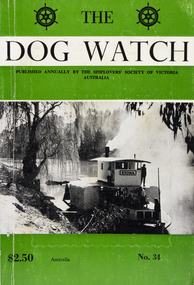
Journal (item) - Periodicals-Annual, Shiplovers' Society of Victoria, The Annual Dog Watch
This journal provides the reader with glimpses of the adventures and hardships of a seaman's life. Many of the stories are of sailing ships. PS Etona was built in 1898 at Milang, South Australia as a missionary church steamer for the Church of England. The Etona's run was from Mannum, South Australia, where she was based up to Renmark. As churches were built in river tower she was no longer required and in 1912 she was sold to Captain Arch Conner who used her as a fishing steamer at Boundary Bend for many years. She was brought out of retirement during the 1956 floods to do trips up the Murrumbidgee River. She was eventually bought by interest in Echuca and restoration was commenced in 1962. The Etona, now fully restored with her original steam engine can now be seen moored along side the historic wharf at Echuca.Contributes to our knowledge of the importance of shipping and places on record those stories of the sea which would otherwise be lost.Contents Foreword - G. F. Tilley - 5 The "Etona" - H. Vaughan Evans - 6 Editorial - Russell Hemingway - 11 The Old Lady Of The River - Captain J. Gaby - 19 "Takapuna" Interlude On A Moonless Night - E. Harper - 31 Maritime Museum of Tasmania - J. Miller - 34 The Confederate Raiders "Florida" and "Alabama" - A. R. Osmond - 36 "Ease After War . . . Doth Greatly Please" - Captain W. J. Cowling - 44 Mutiny At Sea - P. R. Wilkins - 49 War Service In The Indian Ocean - H. Mossman - 51 Cape Horn - Captain Eino Koivistoinen - 57 "Tragedy of Loss" - Jonathan john - 61 The End of The "Queen Elizabeth" - Bradley J. Newell - 62 London Could Cope With Him - Dr. Stanislaw Bernatt - 68 Three Ships Canals - N. S. Smith - 69 The Loss Of The "Eyoshi Maru" - Captain M. B. Glasier - 77 A Small Consignment But Valuable - J. B. Hodgson - 85 Lowden and The "Candida" - D. R. Rickard - 87 "Lauriston" Sails On - F. W. Rudd - 89 Confusion of Identities, "Young Australian", "Young Australia" and "Carl" - J. M. MacKenzie - 93 Rescue from "Clarissa", 1957 - Captain Leif Asklund - 97 Journey Home - Captain W. E. Eastoe - 100 Disaster At Blanket Bay - J. K. Loney - 104 The End Of The "Antiope" - Captain Bruce Bell - 106 The "Great Britain" - C. E. Bonwick - 108 Search The Coast To Shark Bay - Rear-Admiral Charles Adair U.S.N. - 110 The "Polly Woodside" Family - Rev. H. W. Coffey - 121 Book Reviews - 123sailing ships, steamships, shipping, seafaring life, shiplovers' society of victoria, dog watch, murray river, paddlesteamers, echuca, etona, ps etona -
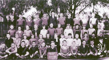
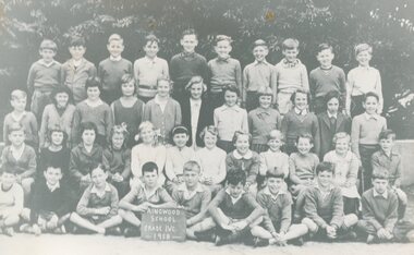 Ringwood and District Historical Society
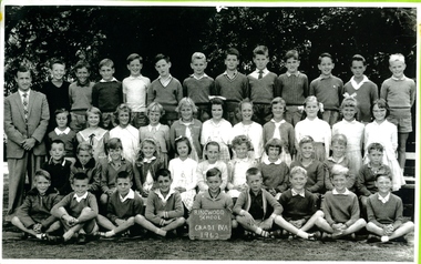
Photograph, Ringwood State School -Class photograph - Grade 4C, 1958
Black and white photograph - Grade 4C,1958"Attached to photograph" Back Row- L to R: Brian Witchurch, Evan Pataullock, David Flower, Robert Neave, Peter Gluyas, Robert Gluyas, Gary Cat, Russell Goodall, Douglas Swarbrick, Albert Jones. 2nd Row - L to R: Andrew Radford, Julie Little, Marilyn John, Glenda Bruce, Ruth Reeves, Lois Clark, Carol Regan, Christine Mehannan, Beverley World, Margaret Doak, Susan Appleby, Grant Austin. 3rd Row - L to R: Lester Coulthard, Jennifer Wilford, Elizabeth (?), Alison Clutterbuck, Ruth Reeves, Elaine Evans, Barbara Austin, Helen Taylor, Beverley World, ?, Robyn McLeish, Neil Miller. Front Row - L to R: ?, Dragon Milotic, David Beith, Robert McCulloch, Peter Pavey, ?, Geoff Davis, Gary Addicot, ?. Teacher: Mr Treloar. -
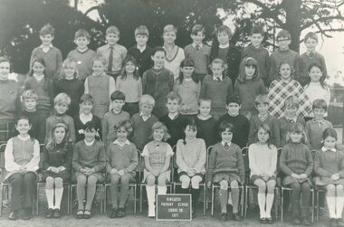
 Ringwood and District Historical Society
Photograph, Ringwood State School - Grade 6B, 1974
Black and white photograph - Grade 6B 1974."Attached to photograph" Back Row- L to R: Shane Clark, Sergio Signor, Rodney Simpson, Russell Zantuck, David Healy, Wayne Kempton, John Matheras, Willy Pouw. 2nd Row- L to R: Linda Parker, Christine Murray, Roseanne Glarimans, Michelle Hogarth, Heather Jones, Eileen Hurley, Jenny Kortland, Kim Edwards, Elizabeth Cuzens. 3rd Row- L to R: Colin Smith, Robert Brown, Keith Pritchard, Jeff Wilke, Martin Lynd, Martin Hamilton, Robert Elliot, Stephen Walton, Stuart Hutchison. Front Row- L to R: Cathy Baker, Heather Butterworth, Karen Chapman, Fairley Marsh, Sharon Venn, Susanne Gempton, Christine Kozel, Karen Rolf, Elizabeth Bailey. Seated On ground: Chris Broadley, ?. Teacher: Mrs Parkes -
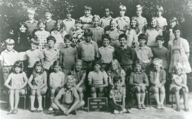
 Ringwood and District Historical Society
Photograph, Ringwood State School - Grade 3B, 1971
Black and white photograph - Grade 3B, 1971."Attached to photograph" Back Row- L to R: Steven Rose, Russell Zantuck, Frank Wolfe, ?, David Butler, Paul Tobias, Adrian Willoughby, Martin Pammelman, David Kinnaburgh, Michael Burch. 2nd Row- L to R: Joanne Gale, Joanna Bowman, Eileen Hurley, Jenny Kartland, Helen Everstein, Michelle Hogarth, Karen Rush, Marlene Morcom, Jenny McGrath, Bronwyn Rutley. 3rd Row- L to R: Kurt Jones, Karl (?), Willy Pouw, Stuart Hutchison, Jason Valentine, David Johnson, Daryl Collins, Michael Allendor, Wayne Kempton, Colin Smith, Rodney Simpson. Front Row- L to R: Christine Murray, Jenny Griffith, Marina Diagardi, Susan Hillman, Debbie Love, Donna Baker, Elizabeth Johnson, Sherrie Johnson, Karen Chapman, Cathy Baker. Teacher: Isobel Marshall -
 Ringwood and District Historical Society
Photograph, Ringwood State School - Grade 6, 1964
Black and white photograph - Grade 6, 1964."Attached to photograph" Back Row- L to R: Meg Flowers, Barbara Donald, Rosemary Weaver, Anne Downey, Ross Anisbett, Carl Gibson, Janet Conlon, Wilhelmina Coenders, Elizabeth Clarke, Christine Schruhn. 2nd Row- L to R: John Tann, Ian Carrington, Gary McCubbin, Ian McCall, Russell Paine, Craig Austin, John Moon, Russell Bourke, Stephen Foster, David Kimberley, Gary Fowler. 3rd Row- L to R: Alan McLean, Leslie Read, Michael Thwaites, Harry Parker, Malcolm Kerr, Howard Archer, Grant Nichol, Ian Jones, Rodney Hason, Peter Ockinghaus. Front Row- L to R: Christine Smith, Kay Langford, Jennyn Flarherty, Linda Jusland, Karen Williamson, Janne Thompson, Janet Guinn, Annette Smeeton, Christine Radford, Diana Hack, Lynette Milne. On Ground: Alan Foley, Daryl Anderson, Chris McDonald, Mark Kulbeak, Peter Maher, David Grant. Absent: Alvina Crawford, Philip Stoker. Teacher: Mr Warriner. -
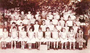
 Ringwood and District Historical Society
Photograph, Ringwood State School - Grade 5A, 1963
Black and white photograph - Grade 5A, 1963."Attached to photograph" Back Row- L to R: Russell Borke, John Snellders, Craig Austin, Barbara Donald, Janet Conlon, Diana Rankin, Debbie Lawrence, Russell Paine, Neil Ratray, Gavin Philips. 2nd Row- L to R: Tommy Colston, Greg Peters, Leslie Reed, Jeffrey Taylor, Gary McCubbin, Gary Davies, ?, John Moon, Barry McDonald, Malcolm Pearson, ?. 3rd Row- L to R: Stephen Gross, Neil Dawe, Jeffrey Fielding, David Kennely, Ian (?), Philip Bates, Jeffrey Ratten, David Kimberly, Robyn Hagar, Malcolm Williams. Front Row- L to R: Karen Williams, Debbie Monk, Elizabeth Clarke, Judy Parker, Linda (?), Jan Thompson, Sally Shaw, Cheryl O'Brien, Rosaland Wiggle, Julie Cook, Rhonda McLeod. On Ground: Michael Craddock, David Connell. Teacher: -
 Ringwood and District Historical Society
Photograph, Ringwood State School - Grade 4A, 1962
Black and white photograph - Grade 4A, 1962"Attached to photograph" Back Row- L to R: Russell Bourke, Robert Taylor, Malcolm Pearson, Russell Paine, Gavin Phillips, Neil Rattray, Gary Davies, ?, Barry McDonald, Craig Austin, Gary McCubbin, John Moon. 2nd Row- L to R: Julie Cook, Jan Thompson, Leslie Gray, Leanne Thorpe, Laurie Simpson,, Debbie Lawrence, Elizabeth Clarke, Roslyn wiggle, Diana Rankin, Wilemina Cook, Janet Conlon. 3rd Row- L to R: Tommy Colston, Stephen Cross, Jeffrey Ratten, Roslyn (?), Sally Shaw, Debbie Monk, Rhonda McLeod, Karen Williams, Ian Jones, Leslie Reed, David Connell. Front Row- L to R: Robin Hagar, Greg Peters, Malcolm Williams, Phillip Bates, David Kimberley, Michael Craddock, David Kennely, Neil Dawe, Jeffrey Fields. Teacher: Mr Delacca -
 Federation University Historical Collection
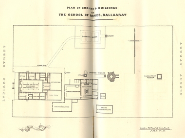
Booklet, Charles Boyd, The School of Mines Ballaarat Annual Report, 1882, 1882
The School of Mines Ballaarat Annual Report 24 January 1882, Additional Examination Statute, Certificates Granted by Council, Copy of letter received from the Honble. Francis Ormond MLC, Extracts from Visitors' Book, Fees, Form of Bequest, Life Governors, Museum open to Visitors, Office Bearers, Paper of Particulars, Report of the Curator of the Museum and Library (with plans), Report of the Superintendent of Laboratories, Report of the Lecturer in Telegraphy, Report of the Lecturer in Mechanical Engineering, Statement of Receipts and Expenditure for the year 1881, Subjects and Lecturers, Subjects and Examiners, Subscriptions and Donations from 1 January to 31 December 1881, The Lignite Deposit at Skipton (with Section and Plan)Ballarat School of Mines Annual Report. Pale brown booklet of 64 pages. A plan of the Ballarat School of Mines shows the position of the Botanical Gardens, and the Ballarat School of Mines Museum. Geological Sketch Map of Country in the Neighbourhood of Skipton and Plan showing site of Coal Discovery. Skipton Coal Discovery - Section of Windlass Shaft. .2) is a leatherbound copyballarat school of mines, coal, plan, ballarat school of mines botanical gardens, ballarat school of mines museum, museum, annual report, james oddie, w. p. bechervaise, s. e. friggis, f. j. martell, w. h. nicholls,, e. i. rosenblum, h. r. caselli, thomas mann, theos. williams, f. m. krause, alf. mica smith, walter d. campbell, w. h. shaw, charles kent, andw. berry, robert adam, wm. lant carpenter, henry parkinson, h. b. de la poer wall, w. h. brockenshire, arthur parker, c. davies, simon richards, c. r. blackett, david jones, wilberforce dyke, kr. r. krauel, duncan love, william ralph heaton, edward dowling, octavius vaughan morgan, william denton, e. h. grimwade, james hunter, the honble. francis ormond, ferdinand krause, a.a. buley, j. cosmo newberry, w.c. kernot, john lewis, j.m. bickett, james bickett, fees, annie barnett, annette budden, isabel clinton, john dimsey, agnes pobjoy, charlotte shaw, bernard o'dowd, bernard patrick o'dowd, josiah wasley, ferdinand von mueller, william kernot, john lynch, william henderson, henry richards caselli, w.p. berchervaise, e.i. rosenblum, w.h. nicholls, lignate, samuel figgis, mary drury, w. longley, botanical reserve, botanical gardens, francis ormond, george russell, william foster stawell, w.j. clarke, rivett henry bland, john warrington rogers, j. lonie, s.e. figgis, r.f. hudson, w. robertson, e.l. rosenblum, theophilus williams, andrew berry, henry sutton, h. rosales, state school classes, calcutta international exhibition, examinations, h.b.m ship bounty, certicates, walter charles kernot, william tunbridge, mary skelton, cartherine moran, mary rose usher, margaret ellen brophy, william burbridge, andrea tuxen, elizabeth curnow, francis campigi, james s. morrison, arthur hogue -
Federation University Historical Collection
Magazine - Emagazine, Fedpress Magazine, 2016-2019
Formerly known as Hotch Potch, FedPress is the student publication of Federation University Australia. FedPress is a space for students to showcase their written and visual talents. The editorial team aim to inform, inspire, and entertain. We are looking for a range of different creative individuals — journalists, reviewers, poets, designers, artists, and photographers — to submit content. FedPress Magazine prints four issues a year and is distributed across FedUni's Ballarat, Wimmera and Gippsland campuses. PDFs of the Federation University Magazine 'fedpress'. Hardcopy of the following years: Issue No 3, October 2014 (Rianh Silvertree, Mathew Lambrou, India McGee, Kayla Elizabeth Stone, Amber Dance, Australian University Games,Amphipipolis Tomb) Issue 4, February 2015 (Kayla Elizabeth Stone. Clubs and Societies, Monash University Gippsland Student Union, Federation University Football Club, Student Senate, Student Connect, Kaitlyn Ashmore, Issue 5, April 2015 (Ellen Sabo, Sexual Education, Gippsland Campus, Monash Campus, Sammy Desai, Zach Mullane, Feduni Living Kakoda Trek) Issue 6, 2015 (Southern University Games, Student Senate, Memories of War Project, Survivors of Suicide, Gippsland Campus, Lucinda Horrocks, Exam Information For Students, Tania McMullenNational Student Leadership Workshop, Mining Games, AUSIMM, The History of MMO, FEdUnied Soccer) Issue 7, July 2015 (PASS - Peer Assisted Study Sessions, Mad Swan Productions, Student Senate, Adam Bignold, Rainh Silvertree, Rebecca Fletcher, Pietro Angeli) Issue 9, October 2015 (Student Senate, Jeannie King, Australian Space Agency, S. Hooley, Rebecca Fletcher, Animal Rights, Breanna Alexander, Pietro Angeli, Jody Dontje, Amanda Mill, Frank Gartlan. Joel King) Issue No 10, 2016 (Unibar, Stone Cutters, Australian Hospitality, Jogy Dontje, Jess Kelly, Pietro Angeli, Getting Through Semester One, Online Student understanding, Liana Skewes, Brianna MacDonald, Student Services, Student Senate, S. Hooley, HECS Help, Ashleigh Dyer, Six things that can cost you easy marks, Laura McLachlan, Surviving grief, Theahna CoburnTenneill Pearl, Rochelle Jardine, Zach Mullane, Dakota Richards, Survival Guide, Scarlette Baum) Issue No 11, May 2016 (Rebecca Fletcher, Joshua Paddon, Hooliganism, Catherine Elliott, Fedpress School of Rock, Dakota Richards, Zach Mullane, Scalette Baum, Clubs, Societies, Sport, FedUni Ultimate Frisbie Club, Geolgoy, Dean DiQuinzio, FedUni Geology Society, Sebastian Wolfe) Issue No 12, 2016 (Crows, Joshua Paddon, Sarah McLean, Fandom, Learn Another Language, Laura McLachlan, Planes, Pietro Angel, Cover Co, mpetition, Megan Corder, Jess Kelly, The Secret Life of Post-Grad Students, Cale Hellyer, What I hate about Facebook, Damian Brown, National Student Vounteer Week, Premnath Chakarvarty, Selin Kasif, Brendan Caffrey, Senate Six, Fed United, Awards, Ultimate Frisbee, Ashleigh Dyer, Cassandra Lovett, Rochelle Jardine, Dakota Richards, Freya Fogliani) Issue No 13, 2016 Issue No. 14, February 2017 Issue No. 15, May 2017 (James Charlton, Rebecca Fletcher, Timothy Kirkham, Mohammad Sami Baardarani, Lajan Maharjan, Jennifer Pont, Kate Williams, Damian Brown, Matthew James, Zoe Ormiston, Freya Fogliani, Myles Hema, Jess Powell) Issue No. 17, October 2017 (Jack Barnes, Damian, Syed Zain Ali, Molly Irvine, Rebecca Fletcher) Issue No. 18, February 2018 (Submission Dates, Guidance for the Shell-Shocked Graduates, Pills, Shark, How to be a Writer, Climate Summit) Issue No. 21, October 2018 (Bianca Bedford, Kelsey Knight, Laura Benney, Rainbow Collective, Smartphone, Sarah McLean, Monique Stephens, Clare Hartigan, Liam Carter) Issue No. 22, March (2018) 2019 (Elizabeth McCracken, Troy Anthony Platt, Liam Carter, O.R. Brayne, Dakota Powell, Elizabeth McCracken, Dan Schweinzer, Jordyn Presley, Sarah McLean, Bianca Bedford, Bronwyn Nel, Beck Small, Tara Parada) Issue No. 23, July 2019 (Beck Small, Jasmyne Tziziras, Jodie Flower-Russell, Maxwell Waterhouse, Dhogaluxmi Chemen, Alisha Hendrick, Elizabeth McCraken, Trent Bowes, Will La Grue, Laura Benney, Sir Troy Anthony Platt, Harrod Boadie, Kathryn Drum, Jordyn Presley, Bianca Bedford, Bronwyn Nel, Olly Brayne, Cherise Oosthuizen, Chloe Waddell, Nyalat Pel Kun, Autism Issue No 25 (April 2021) (Jesse Noonan-Wade, Laura Wilson, Chloe Hopkins, Jordyn Presley, Ruby Sait, Lauren Johnson, Kymberley Loats, Darren Rout, Maddison Gill, Baklava, Covid-19 pandemic, exercisefedpress, brad paisley, selin kasif, dakota richards, emma gamble, damian brown, clare hartigan, tanya bird, freya fogliani, scarlett baum, amanda mill, jess powell, feduni quidditch, rebecca fletcher, bridget o'brien, lisa tops, jordyn presley, jack barnes, emma-lee winters, brook forrest, bianca bedford, jessica rae, laura wilson, laura benney, monique stephens, kelsey knight, sarah mclean, liam carter, bronwynn nel, olly brayne, cherise oosthuizen, chloe waddell, nyalet pel kun, trent bowes, elizabeth mccracken, beck small, jasmine tzaitziras, jodi flower-russell, will la grue, laura benny, maxwell waterhouse, sir troy anthony platt, dhogaluxmi chemen, jarrod boadle, alisha hendrick, autism -
Federation University Historical Collection
Book, University of Ballarat Conferring Ceremony 2003, 2003
Naraelle Carr gave the occasional adress on 09 May 2003. Andrew Dowler made the response on behald of students on 09 May 2003. Professor Kerry O. Cox received an Honorary Degree on 13 May 2003, and made the charge to graduates. Alan Kenneth Webb was made a Doctor of the University (Honoris Causa), and made the occasional address on 13 May 2003. Tanya Weiler made the response on behalf of graduates on 13 May 2003. Robert Hook made the occasional address on the evening of 13 May 2003. Peter Davey gave the response on the on the evening of 13 May 2003. Dr Vicki Williamson made the ocassional address on on 14 May 2003. Lyndal Green made the response on behalf of graduates on on 14 May 2003. Elizabeth Lewis-Gray of Gekko Systems made the occasional address on the evening of 14 May 2003. Andrew Shaw made the response on behalf of graduates on the evening of 14 May 2003. Rosette Sarah Arnold was presnted with the R.W. Richards Medal on the evening of 14 May 2003.Soft covered bookletuniversity of ballarat, graduation, kerry cox, wayne robinson, terry loyd, vicki wiliamsson, robert hook, revor hastings, heather hatfeld, richard de fegely, david caro, william mcgregor, rosemary green, julian lowe, russell bray, lawrence angus, peter swan, greg haines, sidney morris, carla reading, hannelore best, martin westbrooke, virginia fenelon, regalia, mace, alumni, r.w. richards medal, vice-chancellor's award for excellence, academic dress, tanya weiler, alan webb, musa mammadov, dora pearce, louise saxton, narelle carr, andrew dowler, peter davey, vikki williamson, lyndal green, rosette arnold -
Federation University Historical Collection
Booklet, Ballarat School of Mines Annual Report 1888, 1888
Ballarat School of Mines Annual Report 1888. President's Annual Report, Constitution and Statute of Affiliation, Monetary prize by R. M. Serjeant for Treatment of Ores, Balance Sheet: Liabilities and Assets, Certificates Granted by the Council, Fees, Honorary Correspondents, Life Governors, Number of Students attending the School of Mines, Office Bearers, Report of the Curator of the Museum and Library, Report of the Superintendent of Laboratories, Report of the Lecturer on Machine Drawing, Report of the Lecturer on Mechanical Engineering, Report of the Lecturer on Telegraphy, Report of the Lecturer on Botany, Report of the Lecturer on Freehand and Model Drawing, Report of the Lecturer on Materia, Medica and Physiology, Report of the Hon. Secretary St John Ambulance Association, Examinations Held, Scale of Charges for Assays and Analyses, Statement of Receipts and Expenditure for the year 1888 and Special Trust Funds, Statistics - Students Attending Lectures, Subjects and Lecturers, Subscriptions and Donations from 1st January to 31st December 1888, Time Table. Ballarat School of Mines annual Report. Cover attached by tape on booklet, spine missing, 108 pages. ballarat school of mines, annual report, the hon sir william foster stawell, president, andrew anderson, vice president, alf. mica smith - professor of chemistry and metallurgy, f. m. krause - professor of geology and minealogy, j. h. horwood - mechanical engineering, machine drawing and design, mining, mathematics, henry j. hall - freehand and model drawing, daniel walker - chemistry and physics, w. e. burbridge - demonstrator of chemistry and metallurgy, w. d. campbell - telegraphy, george day - botany, j. f. usher - materia, medica, pharmacy and physiology, gilbert j. dawbarn, e. thornton, charles kent - auditor, andrew berry - registrar, t. h. thompson jp - mayor of the city of ballarat, james russell jp - mayor of the town of ballarat, daniel brophy jp - chairman of the band and albion consols, walter gude, elizabeth phillips, thomas commons, kate porritt, emily mary wheeler, grace shrigley, george clendinning, rose ditchburn, cecelia h. murphy, eliza a. turpie, rebecca walton, george g. zilles, william menzies, john waters sutherland, h.w. sutherland, alfred kerr, william coltman, alfred j. dunstan, arthur bregazzi, maggie miller, serna davey, william thomas grownow, sarah davies, anna bella cravno, william corbould, thomas copeland, robert john gribble, henry lipson hancock, leigh george hancock, harry m. martell, ivan rosenblum, john la gerche, samuel barrell, walter reed bechercaise, william treloar, adolf gode, arthur e. lilburne, carl werner, isaac bernstein, george kidd, arthur lynch, henry coltman, josiah wasley, david curtain, martha maud berry, mary ann cameron, harriet mary mitchell, anna s. schloo, ellen fussell, lavinia treloar, mary drury, annie winifred eastwood, annie louisa gatliff, mary gatliff, james edward gribble, frank uren, alfred curthoys, william edwin kernot, j. ditchburn, john bradshaw, david michael curtain, alfred ernest campbell kerr, walter nettleton, william henry keast, george ja,es, donald mcgregor, john king, john bailey bullen, john trevan, patrick murray, josiah curnow, tobert taplin, samuel earnest figgis, w.h. keast -
 Federation University Historical Collection
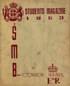
Booklet, J. A. Hoskin & Son, Ballarat School of Mines Students' Magazine, 1953, 1953
Ballarat School of Mines Students' Magazine, 1953White front page soft cover with burgundy inscriptions on front cover. This magazine recognised the coronation of Queen Elizabeth II, and reproduced a portrait of the Queen.staff, sports, her majesty queen elizabeth ii, mr hillman, mr gillespie, i. burger, n. leckie, b. singleton, mr treadwell, mr fairbank, j. mcneil, b. smith, ann mitchell, janice wilton, eleanor tozer, j. beattie, b. macdougall, mr bryan, mrs alf. watson, mr hans fumberger, mr w. r. richards, cliff restarick, russell ewins, kevin whiter, mr w. carlyon, mr k. treloar, mr c. livitsamos, arthur faneco, jim john, barbara ngip, jim tinney, jean dean, neville spiers, stewart rowe, max stevens, barrie smith, elaine walton, jim sawyer, bruce flavel, ron ingleton, john bethune, john blackburn, john boag, jim brokenshire, john carmichael, ray kibby, alec kinnane, noel meagher, norm ludbrook, graham searle, ron sheppard, ryrie mccallum, queen elizabeth ii, coronation -
 Federation University Historical Collection
Book, The Old Pioneers' Memorial History of Melbourne From the Discovery of Port Phillip to the World War, 1924
Blue hard covered book of 494 pages. Images, and a large plan of prominent burials in the Melbourne Old Cemetery, and a Map of Melbourne. melbourne, melbourne cemetery, melbourne old cemetery, john batman, edmund hobson, batman's map, st francis' church, james balfour, mrs hornbrook, paddy's market, wilson hall, working men's college, henry kendall, le souef's cottage, world war one, westernport, melbourne cup, hoddle, collingwood, south melbourne, prahran, richmond, kew, brunswick, coburg, preston, hawthorn, camberwell, nunawading, doncaster, st kilda, brighton, sandringham, cheltenham, caulfield, oalkleigh, footscray, sunshine, north melbourne, carlton, ballarat school of art library, ballarat technical art school, book plate, library plate, hume and hovell's overland journey 1824-5, major mtichell's overland journey, australia felix, booplate, aborigine, aboriginal, captain cook, arthur phillip, isaac smith, george bass, matthew flinders, john murray, catain baudain, captain collins, edward henty, portalnd, map od melbourne in 1938, john pascoe fawkner, the "enterprise: and fawkner's first home, old colonists' homes, rushall crescent north fitszroy, richard bourke, the old melbourne post offfice, old governmnt house, toorak, latrobe's house at jolimont, first melbourne land sale, melbourne water supply, peter henry smith, victorian legislative council opening, map of melbourne and collingwood, prince's bridge, crossing the rivers by punt, f.a> rucker, canvas city emerald hill, arrival of the gold escort in melbourne, the yarra, queen's wharf, tall ships, old st james, mary e. budd, st francis church, michael carr, meolbourne city mission, state library of victoria, melbourne public library, bourke street, angus mcmilan, methodist ladies college, ormond college, armistance celebrations, robert russell, mia mia, theatre royal bouke st, melbourne from flaggstaff hill, federal coffee palace collins st, lord melbourne, melbourne mint, old melbourne town hall, robert russell's melbourne and yarra falls, mandevalle hall, point lansdale lighthouse, wilson's promontory, margaret m. ward cole, williamstown, flinders st melbourne, queenscliff battery, broadmeadows soldiers' camp, embarkation of first troops on the 'ceramic', general monsash, ian hamilton, general bridges, victorian war memorial, national war memorial, st kilda pier, first melbourne cup, hoddle's grid, albert park, melbourne mechanic's institute, st kilda toll gate, munted policeman, springthorpe memorial, james bonwick, mornane's paddock, victorian railways melbourne and surburban lines, carlton gardens, thomas napier, wiliam westgarth, george augustus robinson, william lonsdale, elizabeth mary batman, peomena frances darling batman, dig tree, exhibition of 1854, exhibition of 1866, exhibition buildings, geelong harbour, jubilee lake, port campbell, warrnambool, queenscliff lightboat, batman's first house -
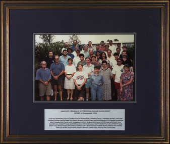 Federation University Historical Collection
Photograph, Graduate Diploma in Occupational Hazard Management Intake 16, 1992, 1992
Victorian Institute of Occupational Safety and Health (VIOSH) Australia is the Asia-Pacific centre for teaching and research in occupational health and safety (OHS) and is known as one of Australia's leaders on the field. VIOSH has a global reputation for its innovative approach within the field of OHS management. VIOSH had its first intake of students in 1979. At that time the Institution was known as the Ballarat College of Advanced Education. In 1990 it became known as Ballarat University College, then in 1994 as University of Ballarat. It was 2014 that it became Federation University. VIOSH Australia students are safety managers, senior advisors and experienced OHS professionals. They come from all over Australia and industry. Students are taught active research and enquiry; rather than textbook learning and a one-size fits all approach. VIOSH accepts people into the Graduate Diploma of Occupational Hazard Management who have no undergraduate degree - on the basis of extensive work experience and knowledge. Timber framed colour photograph of forty peopleTitle plate with all the names of the students typed.viosh, viosh australia, graduate diploma in occupational hazard management, ted allen, jacqueline bednarski, david borys, wayne burgess, adrian cafferkey, merrilyn cardwell, sally cole, christine dawson, easaw easaw, majorie fitzgerald, john gordon, brian hastings, elizabeth hatton, joe kamin, deborah kelly, david kemp, christopher lacey, stephen lawson, mark linke, john lodder, peter mcdonald, john mcgarry, david mallett, jonathon mandley, miroslav nikolic, jennifer nizette-barratt, mark paterson, susan resta, dwight rouse, philip royce, john runnalls, russell scott, stephen standen, timothy strickland, neville tapscott, anne taylor, adrienne tilling, jim toshach, gary wilson, john young, ballarat university college -
 Ringwood and District Historical Society
Photograph, Ringwood State School - Grade 4B, 1960
Black and white photograph"Attached to photograph" Back Row- L to R: Bruce Taylor, ?, John Gadsden, Andrew Glavimans, Ray Reid, Jim(Bill) Noble, Glen Ennis, Peter Jenkins, Colin Doak, Michael Jackson, Geoff Sjogren. 2nd Row- L to R: Rosemary Cini, Karalee Bacon, Belinda Clarke, Rase Moller, Leonie Munro, Robyn Whitchurch, Stephanie Ivanovic, Janine Brooks, ?, Jeanne Myles, Marion Mitchell, Heinz Bansagi. 3rd Row- L to R: Robert Bradley, Terry Martin, Annette Bousaid, Cheryl-Ann Mitchell(?), Stephanie Tann, ?, Elizabeth Carter, Judith Flaherty, ?, ?, Billy Harding, Greg Jacobs, Stephen Dawe. Front Row- L to R: ?, Stephen Lavender, Robert Russell, David Buchan, Richard Carter, Ian Uren, Peter Evans, David Cleator, Gary Sinclair, Clive Connolly, Peter Brown. Teacher: -
 Ringwood and District Historical Society
Photograph, Ringwood State School - Grade 5B, 1961
Black and white photograph"Attached to photograph" Back Row- L to R: Colin Jones, Michael Anderson, Billy Harding, Peter McGoldrick, Robert Russell, Trevor Welsh, Peter Crettenden, Brian McCord, Richard Carter. 2nd Row- L to R: Terry Martin, Clive Connolly, David Church, ?, Daryl Hall, ?, Alistair Wardle, Geoff Bomford, Ian Cannan, Michael Bangay, Ian Uren. 3rd Row- L to R: Gustave Cole, Hella Demidou, Judith Wigley, Jenny Miles, Lynette Allen, Geoff Ward, Ronnie Harrison, Helen King, Marion Mitchell, Jeanne Myles, Ray Read. Front Row- L to R: Jane Taylor, Diana Logan, Karalee Bacon, Heather Parker, Dianne Fitzgerald, Leonie Munro, Marie Hargreaves, Elizabeth Carter, Carol DeLabertouche, Linda Camp. Teacher: -
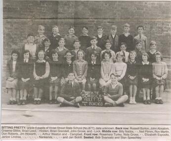 Bendigo Historical Society Inc.
Newspaper - JENNY FOLEY COLLECTION: SITTING PRETTY
Bendigo Advertiser '' The way we were'' from 2002. Sitting pretty: grade 6 pupils of Violet Street State School (No 877), date unknown. Back row: Russell Burton, John Absalom, Graeme Gibbs, Brian Leed, ? Holden, Brian Grendell, John Grose and ? Lock. Middle row: Billy Nabbs, ??, Neil Plimm, Ron Martin, Don Roberts, Jim Howarth, ??, Arthur Weston and ? Campbell. Front row: Rosemary Turley, Nola Grose, ??, Elizabeth Esposoto, Janice Lindrea, ??, ??, ??, ? Nankervis, ??, ?? And Jan Botrill. Seated: Bob Svanosio and Stan Speechley. The clip is in a folder.newspaper, bendigo advertiser, the way we were -
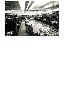 Ithacan Historical Society
Photograph, Russell Collins Restaurant, 26 April 1973
The Russell Collins Restaurant was located in the basement of the T&G Building on the south west corner of the Collins and Russell Streets intersection. It was a popular 'up-market' restaurant from the 1940s until the early 1970s when the T&G building underwent alterations. The restaurant, like its counterpart Elizabeth Collins, was renowned for its large platters of delicious salads. Nick (Naki) Raftopoulos operated the Russell Collins during the early 70s up until its closure.A black and white photograph of the interior of an Art Deco style restaurant fitted out around the walls with wooden 'shoulder high' cubicles which seated four people. Tables and chairs with various settings are arranged in the open areas of the restaurant. The floor is a wooden herringbone parquetry with a carpet on the floor in the reception area. Handwritten across the bottom of the photo: RUSSELL COLLINS RESTAURANT NICK RAFTOPOULOS.art deco, russell collins restaurant, restuarants -
 Bendigo Historical Society Inc.
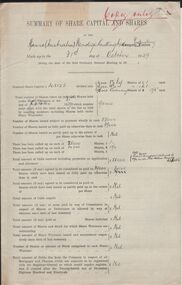
Document - HANRO COLLECTION: SUMMARY OF SHARE CAPITAL AND SHARES - OCTOBER 1929
Summary of Share Capital and Shares of the Hanro (Australia) Bendigo Knitting Mills Company Proprietary Limited made up to the 31st day of October 1929 which have the names, addresses and occupations of the shareholders.hanro, clothing, share register, hanro collection - summary of share capital and shares, harry francis longstaff, william hall russell, charles handschin, consortium hanro, caterine hunter, favaloro bros, george victor lansell, edith lansell, william wright, william john stephens, audrey edith lansell, marie gwendoline lansell, patricia hope lansell, alexander lewis goldie, lillie goudie mcgregor, herbert keck, smalley balmer & cook, william bowman h neill, ronald alexander rankin, john jepson stanistreet, eugene bloch, william crowley, mabel gittins, mary anderson, kenneth smalley, john raeburn balmer, william reddish cook, favaloro domeric, katie bloch, evelyn adrienne neill, elizabeth neill, alice handschin, caroline goldie, francesca black, marie maranta, ernest gossweiller, e f granger -
 Bendigo Historical Society Inc.
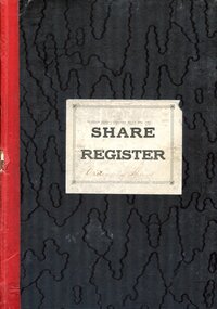
Book - HANRO COLLECTION: SHARE REGISTER 1933 - 1950
Share Register with a black patterned cover and red cloth tape spine. Entries from 1933 to 1950. Label on the front has Hanro (Aust) Knitting Mills Pty Ltd, Share Register (printed) and Ordinary Shares (handwritten). Index at the front of book. name, address and occupation are listed at the top of the double page. Columns for date, particulars, No of Transfer, Distinctive Nos - From and To, DR, Cr, Balance of Shares Held, Distinctive Nos Held - From and To, Dr - Date and Amount, and Cr - Date and Amount. Book only partly used. Each double page is numbered.hanro, clothing, share register, hanro collection - share register 1933 - 1950, mary anderson, eugen bloch, john raeburn balmer, katie bloch, estate sydney raeburn balmer, consortium hanro, william crowley, william r cook, favoloro's investment co pty ltd, fiduciaire generale sa, alexander lewis goldie, mabel gittins, albert vivian gray, chas handschin (dec'd), alice handschin, catherine hunter, william dill hunter, annie chambers hunter, mary elizabeth hunter, frank harris, wiliam roy hiscock, herbert keck, harry francis longstaff, george victor lansell, edith lansell, audrey e lansell, marie g lansell, patrica h lansell, jane t lyons, lillie goudie mcgregor, philip henry mckean, alan t miller, william bowman hanna neill, evelyn adrienne neill, elizabeth neill, edith fortuna victoria norbury, r a rankin, w h russell, w j stephens, j smalley balmer cook, john jepson stanistreet, kenneth smalley, johnathon smalley, royal james v stilwell, william oliver stephens, william wright -
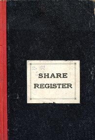 Bendigo Historical Society Inc.
Book - HANRO COLLECTION: ORDINARY SHARE REGISTER 1926 - 28
Black book with red cloth tape spine and a sticker on the front with Share Register printed on it. Written inside front cover is Ordinary Share Register. Share entries dated from 1926 to 1929. Register contains shareholders name, address and occupation, shares held and their numbers which are listed, who they may have been transferred to, Nos held, date and amount. Shareholders names are: Harry Francis Longstaff, William Hall Russell, Thomas Miller, Charles Handschin, Consortium Hanro, Mrs Catherine Hunter, Favaloro Bros, George Victor Lansell, Edith Lansell, William Wright, William John Stephens, Audry Edith Lansell, Marie Gwendolin Lansell, Patrica Hope Lansell, Alexander Lewis Robertson Goldie, Mrs Lillie Goudie McGregor, Herbert Keck, Smalley Palmer & Cook, William Neill, Hanna Bowman, Ronald Alexander Rankin, John Jepson Stanistreet, Eugene Bloch, Eugene Gerber, William Crowley, William Hall Russell, Stirling, Vernon Rymer, Mabel Gittins, Mrs Mary Anderson, Kenneth Smalley, John Raeburn Balmer, William Reddish Cook, Domeric Favaloro, Johnathon Smalley, Katie Bloch, Evelyn Adrienne Neill, Rosemont and Elizabeth Neill.hanro, clothing, share register, hanro collection - ordinary share register 1926 - 28, harry francis longstaff, william hall russell, thomas miller, charles handschin, consortium hanro, mrs catherine hunter, favaloro bros, george victor lansell, denderah, edith lansell, fortuna, william wright, advertiser office, william john stephens, audry edith lansell, marie gwendolin lansell, patrica hope lansell, alexander lewis robertson goldie, mrs lillie goudie mcgregor, herbert keck, smalley palmer & cook, william neill, hanna bowman, ronald alexander rankin, john jepson stanistreet, eugene bloch, eugene gerber, william crowley, william hall russell, stirling, vernon rymer, mabel gittins, mrs mary anderson, kenneth smalley, john raeburn balmer, william reddish cook, domeric favaloro, johnathon smalley, katie bloch, evelyn adrienne neill, rosemont, elizabeth neill -
 Bendigo Historical Society Inc.
Document - HANRO COLLECTION: SUMMARY OF SHARE CAPITAL AND SHARES
A collection of documents listing the names of shareholders. A Statement of Shareholdings, dated 4.3.32 and a list of Ordinary Shares,dated 13.5.?89.hanro, clothing, share register, hanro collection - summary of share capital and shares, harry francis longstaff, william hall russell, charles handschin, consortium hanro, caterine hunter, favaloro bros, george victor lansell, edith lansell, william wright, william john stephens, audrey edith lansell, marie gwendoline lansell, patricia hope lansell, alexander lewis goldie, lillie goudie mcgregor, herbert keck, smalley balmer & cook, william bowman h neill, ronald alexander rankin, john jepson stanistreet, eugene bloch, william crowley, mabel gittins, mary anderson, kenneth smalley, john raeburn balmer, william reddish cook, favaloro domeric, katie bloch, evelyn adrienne neill, elizabeth neill, alice handschin, caroline goldie, francesca black, marie maranta, ernest gossweiller -
 Lake Bolac & District Historical Society
Black and white photograph, First intake of students, 1957, to the Lake Bolac Higher Elementary School
The first intake of Students in 1957, in the Presbyterian Sunday School as the school buildings were still being constructed. Students from left to right, Back: Russell Adams, Max Davis, Jack Moss, Charlie Neil, Fred Collins, Teacher - Joe Skeehan, Ian Farnsworth, Ken Collins, Winston Jenkins, Richard Thom, Gordon Hucker. Middle: Robert Maddox, Pam Debney, Gwenda Drever, Elizabeth Copley, Judith Barrett, Maxine Mauldin, Wendy Phillips, June Burdett, Ray O'Brien. Front: Daryl Heard, Ken Wilson, Richard Peters, Douglas Park, Murray Thom, Robert Fraser, James Hildebrandt. Len Renkin absent.lake bolac higher elementary school, adams, barrett, burdett, collins, copley, davis, debney, drever, farnsworth, fraser, heard, hildebrandt, hucker, jenkins, mabin, maddox, moss, neil, o'brien, park, peters, (rankin), skeehan, thom, wilson -
Tatura Irrigation & Wartime Camps Museum
Photographs, Burton family
Photographs emailed to researchers. Burton Hall and Burton family photographs:|Photo No.1. Mary Russell nee Burton.|2. Hannah Burton.|3. Abel Burton.|4. Sarah Mitchell nee Burton.|5. Rachel Mills nee Burton.|6. Isaac Burton.|7. Alice Burton.|8. Julia Burton.|9. Elizabeth Burton.|10. Aggie Burton nee Menzies, wife of Abel.|11. Emma Burton, 1824-1906.|12. James Burton, 1818-1905.|13,14. Sarah Burton nee Mitchell (from Mrs. Black)Photos 11 to 12 emailed, 13 & 14 sent by Mrs. Black, no originals held at Museum. -
 Robin Boyd Foundation
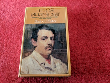
Book, Elizabeth Salter, The Lost Impressionist: A biography of John Peter Russell, 1976
... Impressionist: A biography of John Peter Russell Book Elizabeth Salter ...Hardcoverjohn peter russell, walsh st library