Showing 214 items matching "eltham roads board"
-
 Eltham District Historical Society Inc
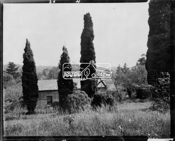
Negative - Photograph, Shillinglaw Cottage, 17 Oct. 1963
... of assessable rates levied by the Eltham District Road Board... of assessable rates levied by the Eltham District Road Board ...Shilinglaw Cottage in its original location on Main Road Eltham with the three Mediterranean Cypress trees (“Shillllinglaw trees”) in the garden. Note a fourth pine to the right. This image was taken shortly before its relocation. Believed to be have been taken by John Collins, 17 Oct 1963 as per other images held by the State Library of Victoria Author / Creator: John T Collins 1907-2001 , photographer. J.T. Collins Collection, La Trobe Picture Collection, State Library of Victoria. Shillinglaw Cottage is significant to Eltham’s local history. It is one of the earliest known buildings still in existence. Records suggest that the cottage was built circa 1859 by a man named Cochrane, believed to be Thomas Cochrane, in conjunction with George Stebbings though it is not known what Stebbings’s contribution was. It is made from hand made bricks laid in a Flemish bond pattern. In the 1960s it was marked for demolition to make way for the construction of new council buildings but a community campaign saved the cottage and it was re-located. It is believed Stebbings owned the cottage between 1874 and 1888. According to Margaret Ball’s (2017) book Shillinglaw Family of Eltham 1660-2007, Thomas Cochrane and family lived there from 1867 to 1874 however this is contrary to the records of assessable rates levied by the Eltham District Road Board, established in 1858, which shows Cochrane was the owner occupier (in Little Eltham) of approximately 25 acres of cultivated land and 25 acres of pastureland upon which a hut was sited in 1860. It is suspected that George Stebbings may have acquired the property from Cochrane in 1874 as it is noted that he had a tenant for a period, James Rossiter, who was the editor for the Evelyn Observer in Kangaroo Ground in 1874 (LATE SHIRE OFFICE AT KANGAROO GROUND (1934, February 16). Advertiser (Hurstbridge, Vic. : 1922 - 1939), p. 5. Retrieved February 25, 2022, from http://nla.gov.au/nla.news-article56743657). In 1881 Phillip Shillinglaw became the ratepayer for the cottage though Stebbings retained ownership until 1888 at which time it was transferred to Shillinglaw.Shillinglaw Cottage is itself historically, aesthetically and socially significant to the Shire of Nillumbik and is registered on the Victorian Heritage Database. This photo forms part of a collection of photographs gathered by the Shire of Eltham for their centenary project book, "Pioneers and Painters: 100 years of the Shire of Eltham" by Alan Marshall (1971). The collection of over 500 images is held in partnership between Eltham District Historical Society and Yarra Plenty Regional Library (Eltham Library) and is now formally known as 'The Shire of Eltham Pioneers Photograph Collection.' It is significant in being the first community sourced collection representing the places and people of the Shire's first one hundred years.Digital image 4 x 5 inch B&W Negsepp, shire of eltham pioneers photograph collection, eltham, shillinglaw cottage, significant tree -
![Book, Leslie Arthur Schumer, Henry Dendy and his emigrants / [by] Leslie A. Schumer, 1975](/media/collectors/4f729f7b97f83e03086018a5/items/590860a8d0ce9c14e834a413/item-media/5bac378021eb061568d29027/item-fit-380x285.jpg) Eltham District Historical Society Inc
Eltham District Historical Society IncBook, Leslie Arthur Schumer, Henry Dendy and his emigrants / [by] Leslie A. Schumer, 1975
... on the Eltham District Roads Board including one term as President... on the Eltham District Roads Board including one term as President ...Henry Dendy (1800-1881) is best known as the founder of Brighton. It is not well known that years later he lived far longer at Eltham than he did at Brighton. In 1840 whilst still in England, he bought eight square miles of unspecified land in the Port Phillip district. This entitled him to bring a number of other people to the colony and in 1841 he arrived in Williamstown in the York with his family and 139 others. He took up this land entitlement at what is now Brighton and most of the emigrants settled there. He encountered financial problems and lost his interest in the estate in 1844. He left Brighton in 1847. He successfully not always successfully became a brewer at Geelong, a sheep farmer at Christmas Hills and Upper Moira, a flour miller at Eltham, a sheep farmer again at Werribee and finally a copper miner at Walhalla. Dendy came to Eltham in 1856 after having spent a year in England, he purchased about 5 acres of land in two parts situated each side of Maria Street (Main Road). There was a steam flour mill on that part of the land adjoining the Diamond Creek. He became prominent in local affairs serving for a time on the Eltham District Roads Board including one term as President. Dendy’s wife Sarah died at Eltham in 1860 and also in that year he was appointed Chairman of a committee to establish a Church of England in Eltham. He donated one of his Pitt Street lots for this purpose. St Margaret’s Church was opened on this site in 1861. In 1867 Dendy sold his mill to W F Ford and moved to Werribee and then Walhalla where he remained until his death. He is buried in the Walhalla cemetery. Part of the land on which the Eltham Community Reception Centre stands was the site of Dendy’s house and Mill. Some of the old trees on the site could well have been planted in Dendy’s time. Much of this information was obtained from the book “Henry Dendy and his Emigrants” by L A Schumer. ISBN 095971040X Paperback; viii, 88 p. : maps ; 22 cm. [written inside front cover] To J.W. Wainbech(?) with the author's compliments and thanks. 22/12/75 [and signed by the author on the cover page]henry dendy, brighton (vic.), emmigration, pioneers -
 Eltham District Historical Society Inc
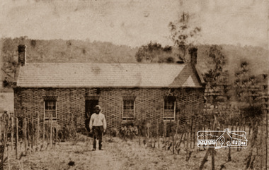
Photograph, Thomas Cochrane in front of his family home, in Little Eltham, c.1865
... , circa 1865. When the Eltham District Road Board was established..., circa 1865. When the Eltham District Road Board was established ...Originally catalogued around 1998 as John Cochrane in front of Shillinglaw Cottage, this is now believed to be Thomas Cochrane born 1817 in Ireland. The photograph is a reproduction of a low-resolution, poor-quality photograph. Shillinglaw Cottage is significant to Eltham’s local history. It is one of the earliest known buildings still in existence. Records suggest that the cottage was built circa 1859 by a man named Cochrane, believed to be Thomas Cochrane, in conjunction with George Stebbings though it is not known what Stebbings’s contribution was. It is believed Stebbings owned the cottage between 1874 and 1888. According to Margaret Ball’s (2017) book "Shillinglaw Family of Eltham 1660-2007", Thomas Cochrane and family lived there from 1867 to 1874 however this is contrary to the records of assessable rates levied by the Eltham District Road Board, established in 1858, which shows Cochrane was the owner occupier (in Little Eltham) of approximately 25 acres of cultivated land and 25 acres of pastureland upon which a hut was sited in 1860. It is suspected that George Stebbings may have acquired the property from Cochrane in 1874 as it is noted that he had a tenant for a period, James Rossiter, who was the editor for the Evelyn Observer in Kangaroo Ground in 1874 (LATE SHIRE OFFICE AT KANGAROO GROUND (1934, February 16). Advertiser (Hurstbridge, Vic. : 1922 - 1939), p. 5. Retrieved February 25, 2022, from http://nla.gov.au/nla.news-article56743657). In 1881 Phillip Shillinglaw became the ratepayer for the cottage though Stebbings retained ownership until 1888 at which time it was transferred to Shillinglaw. Thomas Cochrane was born in Ireland in 1817 and died at Collingwood 1877. He married Sarah Jane Casey at St James, Melbourne in 1846. They had eight children: • Elizabeth Jane Cochrane born 1847, Keelbundoora • Sarah Cochrane born 1849, Keelbundoora • William John Cochrane born 1854, Eltham • Isabella Mary Cochrane (Cochren) born 1855, Eltham, my Great grandmother • Mary Cochrane born 1857, Eltham • Thomas Cochrane born 1859, Eltham • William James Cochrane born 1861, Eltham • Margaret Anne Cochrane (Cochran) born 1863, Eltham Information received from Richard Stone in 2019, a 2nd-great grandson of Thomas Cochrane suggests that during the early 1930s, one of Isabella’s daughters and her family attended cricket matches at Eltham. The mother and a daughter (Richard’s cousin) would wander around Eltham and a cottage in the main street backing onto the cricket ground. The cousin remembers well her mother telling her that her mother, Isabella Cochrane, lived in the cottage as a young girl. The family also had a similar or the same photo of a man standing in front of the cottage. When the Cochrane family left the cottage in 1874, Thomas Snr would have been 57 and Thomas Jnr 15 and William 13. The man in the photo has a dark and substantial beard. Therefore, it is unlikely to be Thomas Jnr or William and most likely Thomas Snr. The photo is of poor quality and low resolution however, there is little grey evident in his beard. It was possibly taken when Cochrane was a younger man shortly after the cottage was built, circa 1865. When the Eltham District Road Board was established in 1858, the forerunner to Eltham Shire Council, Thomas Cochrane was listed as the occupier/owner of two assessable parcels of farmland in Little Eltham: one of 21 acres of pastureland and another 22 acres of cultivation land. George Stebbings was not recorded as an occupier or landowner. In 1859 and 1860 a Joseph/Joshua Stebbings was recorded as the occupier of a hut owned by G. Atkinson. A hut was recorded on Cochrane’s pastureland parcel in 1860 and this parcel increased in size to 36 acres in 1861 and grew further in size by 1863. George Stebbings first appears as the owner/occupier of a hut in Eltham in 1861, also 1862 and 1863. This is most likely his cottage (still standing in present day) in Pitt Street adjoining the Eltham Hotel property owned by Benjamin Wallis where he was residing in 1867 when they both sued each other for trespass. (POLICE. (1867, August 9). The Argus (Melbourne, Vic. : 1848 - 1957), p. 7. Retrieved February 25, 2022, from http://nla.gov.au/nla.news-article5774640) Thomas Cochrane was appointed one of the original trustees of the ground set aside for Eltham Cemetery in Feb 1860 (GOVERNMENT GAZETTE. (1860, February 11). The Argus (Melbourne, Vic. : 1848 - 1957), p. 7. Retrieved February 25, 2022, from http://nla.gov.au/nla.news-article5676991)A very early photo of Shillinglaw Cottage with its original builder and owner/occupier, Thomas Cochrane. Cochrane was also a founding Trustee of the Eltham Cemetery Trust. Reproduction of sepia photographshillinglaw cottage, eltham, eltham cemetery trust, evelyn observer, george stebbings, james rossiter, little eltham, phillip shillinglaw, thomas cochrane -
 Eltham District Historical Society Inc
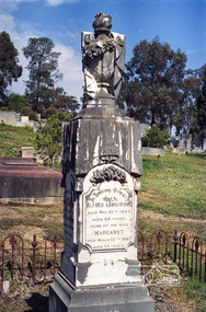
Negative - Photograph, Harry Gilham, Grave of Alfred and Margaret Armstrong, Eltham Cemetery, Victoria, Sep 2009
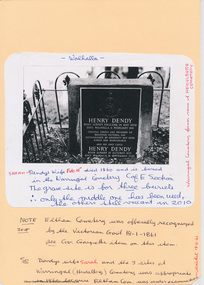
... was elected to the Eltham District Road Board (forerunner of Eltham... was elected to the Eltham District Road Board (forerunner of Eltham ...Alfred Patrick Armstrong was born in England in 1825 and was employed under the renowned Isambard Kingdom Brunel as a civil engineer during the construction of the Great Western Railway and the South Wales Railway. He came to Melbourne in 1852 and purchased property in Eltham. He became a mining surveyor and was Inspector of Mines and the Mining Registrar for the St Andrews Division of the Castlemaine Mining District. In 1855, he chaired a meeting calling for a bridge to be erected across the Yarra River between Eltham and Temple Stow. He was registered as an innkeeper in 1858, was a recognised collector of the £110 raised for the building of the first building of State School No. 209 (Eltham Primary) and was a Trustee for the Church of England site on the Eltham Cemetery Trust in 1860. He was elected to the Eltham District Road Board (forerunner of Eltham Shire Council) from 1867 to 1871 and then served as an Eltham Shire Councillor from 1871 to 1878 (including Shire President in 1873). Margaret Armstrong to whom he was married in 1854 at St Pauls Church, Melbourne, died on the 27th March 1887. Alfred died in 1893, having been in ill health for some time, and is buried in Eltham Cemetery with his wife Margaret. The monument features a tall pillar capped with a draped urn: a symbol of death. In Loving Memory of Alfred Armstrong Died May 27tth 1893 Aged 68 years Also of his wife Margaret Died March 27th 1887 Aged 63 years This burial site is of special interest as the monument has the tallest pillar-a vase-a draped cloth top (unfulfilled life) and additional panels of names around the sides and the base, which include: Ada Gertrude Armstrong, beloved daughter of Alfred & Margaret Armstrong, died May 30th 1878, aged 21 years Mary Armstrong, beloved mother to Alfred Armstrong, died April 10th, 1886 aged 82 years Arthur Vivian Harrison, died 4th Nov. 1899, aged 8 years Arthur Reynolds Stockwood Armstrong, son of Alfred Armstrong, died 4th Nov. 1908, aged 43 years Laura Augusta Harrison nee Armstrong, died 26th July 1921, aged 64 yearsRoll of 35mm colour negative film, 6 stripsKodak GC 400-9eltham cemetery, gravestones, alfred armstrong, margaret armstrong, ada gertrude armstrong, arthur reynolds stockwood armstrong, arthur vivian harrison, laura augusta harrison (nee armstrong), mary armstrong -
 Eltham District Historical Society Inc
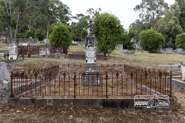
Photograph, Peter Pidgeon, Grave of Alfred and Margaret Armstrong, Eltham Cemetery, Victoria, 5 April 2021
... was elected to the Eltham District Road Board (forerunner of Eltham... was elected to the Eltham District Road Board (forerunner of Eltham ...Alfred Patrick Armstrong was born in England in 1825 and was employed under the renowned Isambard Kingdom Brunel as a civil engineer during the construction of the Great Western Railway and the South Wales Railway. He came to Melbourne in 1852 and purchased property in Eltham. He became a mining surveyor and was Inspector of Mines and the Mining Registrar for the St Andrews Division of the Castlemaine Mining District. In 1855, he chaired a meeting calling for a bridge to be erected across the Yarra River between Eltham and Temple Stow. He was registered as an innkeeper in 1858, was a recognised collector of the £110 raised for the building of the first building of State School No. 209 (Eltham Primary) and was a Trustee for the Church of England site on the Eltham Cemetery Trust in 1860. He was elected to the Eltham District Road Board (forerunner of Eltham Shire Council) from 1867 to 1871 and then served as an Eltham Shire Councillor from 1871 to 1878 (including Shire President in 1873). Margaret Armstrong to whom he was married in 1854 at St Pauls Church, Melbourne, died on the 27th March 1887. Alfred died in 1893, having been in ill health for some time, and is buried in Eltham Cemetery with his wife Margaret. The monument features a tall pillar capped with a draped urn: a symbol of death. In Loving Memory of Alfred Armstrong Died May 27tth 1893 Aged 68 years Also of his wife Margaret Died March 27th 1887 Aged 63 years This burial site is of special interest as the monument has the tallest pillar-a vase-a draped cloth top (unfulfilled life) and additional panels of names around the sides and the base, which include: Ada Gertrude Armstrong, beloved daughter of Alfred & Margaret Armstrong, died May 30th 1878, aged 21 years Mary Armstrong, beloved mother to Alfred Armstrong, died April 10th, 1886 aged 82 years Arthur Vivian Harrison, died 4th Nov. 1899, aged 8 years Arthur Reynolds Stockwood Armstrong, son of Alfred Armstrong, died 4th Nov. 1908, aged 43 years Laura Augusta Harrison nee Armstrong, died 26th July 1921, aged 64 yearsBorn Digitaleltham cemetery, gravestones, ada gertrude armstrong, alfred armstrong, arthur reynolds stockwood armstrong, arthur vivian harrison, laura augusta harrison (nee armstrong), margaret armstrong, mary armstrong -
 Eltham District Historical Society Inc
Document - Folder, Dendy, 2012
... on the Eltham District Road Board, including one year as President... on the Eltham District Road Board, including one year as President ...Henry Dendy (1800-1881) was an early settler of Eltham where he operated a flour mill. He donated land for the construction of St Margaret's Anglican Church. EDHS Newsletter No. 168 May 2006 Dendy is best known as the founder of Brighton, but it is not so well known that years later he lived at Eltham for far longer than he lived at Brighton. In 1840 while still in England he bought eight square miles of unspecified land in the Port Phillip District. This entitled him to bring a number of other persons to the colony and in 1841 he arrived at Williamstown in the "York" with his family and 139 others. He took up his land entitlement at what is now Brighton and most of the emigrants settled there. He encountered financial problems and lost his interest in the estate in 1844. He left Brighton in 1847. He successively but not always successfully became a brewer at Geelong, a sheep farmer at Christmas Hills and Upper Moira, a flour miller at Eltham; a sheep farmer again at Werribee and finally a copper miner at Walhalla. Dendy came to Eltham in 1856 after having spent a year in England. The total of the two parcels of land that he bought was about 5 acres (2 hectares) and it included the steam flour mill. . He became prominent in local affairs, serving for a time on the Eltham District Road Board, including one year as President. Dendy' s wife Sarah died at Eltham in 1860 and also in that year he was appointed chairman of a committee to establish a Church of England in Eltham. He donated one of his Pitt Street lots for this purpose and St Margaret's was opened in 1861. In 1867 Dendy sold his mill to W. F. Ford and moved to Werribee and then Walhalla where he remained until his death. He is buried in the Walhalla cemetery. No sign of Dendy's house or mill remain on the Community Centre site but some of the old trees running along the former boundary through the centre of the site could well have been planted in Dendy' s time. Much of this information was obtained from the book ''Henry Dendy and his Emigrants" by L.A. Schumer (Sallas Books 1975). The Society has an extensive file of Dendy information, much of it provided by the late Leslie Schumer. Manilla folder of information. Includes Folder 88 from Harry Gilham Collection which includes EDHS tour notes of St Margaret's Anglican Church, Eltham, 2012, copy of newspaper article, Diamond Valley News, December 15, 1981, copy of newspaper article, The Advertiser, September 2, 1932, photocopy of photograph of graves at Walhalla Cemetery and Warringal Cemetery, photocopies, 6 pages from an unsourced book. henry dendy, st margaret's anglican church, catholic section, eltham cemetery, harry gilham collection, sarah dendy, walhalla cemetery -
 Eltham District Historical Society Inc
Photograph - Digital Photograph, Alan King, Pigeon Bank, Kangaroo Ground-Warrandyte Road, Kangaroo Ground, 6 February 2008
... was a member of the Eltham Road Board (which preceded the Shire Council... was a member of the Eltham Road Board (which preceded the Shire Council ...In 1848, Francis Rogerson form Dumfriesshire, Scotland purchased 80 acres of land at Kangaroo Ground on which he built a two-roomed bark hut. He named the property afterr the many Bronzewings and Wonga Pigeons in the area. Ewen Hugh Cameron moved to Pigeon Bank the same year he was elected to Parliament as the Member for Evelyn. At the time he moved in, Pigeon Bank had six rooms and the present water well. He made further extensive additions and lived there until his death in 1915. Covered under Heritage Overlay, Nillumbik Planning Scheme. Published: Nillumbik Now and Then / Marguerite Marshall 2008; photographs Alan King with Marguerite Marshall.; p27 Pigeon Bank, on the Kangaroo Ground – Warrandyte Road, Kangaroo Ground, is one of the Shire’s oldest farm dwellings, and has been home to some of the district’s earliest and most distinguished families. Although close to the road, the white weatherboard Victorian farmhouse is ensured privacy by the trees and hedges around it. On 4.8 hectares of farmland, Pigeon Bank is surrounded by rolling hills, farmland and bush, the peace of which is punctuated by an occasional birdcall. Pigeon Bank’s first owner was Francis Rogerson, from Dumfriesshire, Scotland, who bought 80 acres (32.4ha) of land in 1848 on which he built a two-roomed bark hut. Today this is the centre piece of the 14-room home.1 Rogerson lined the rooms with tongue-and-groove boards and roofed them with wooden shingles and sapling frames, which remain under the present green corrugated iron roof. He named Pigeon Bank after the many forest bronzewing and Wonga Pigeons in the area at the time, and the name Bank was commonly used in Scotland. Rogerson was united with one of the oldest families in the area when his sister Janet married John Bell, son of William, the original Bell settler. When Ewen Cameron moved to Pigeon Bank in 1874 it had six rooms and the present water well. He made extensive additions to the house and farm buildings and lived at Pigeon Bank until his death in 1915. Cameron, who had arrived in Melbourne from Scotland in 1853, contributed an enormous amount to the community. He worked as a builder, as a miner at Andersons Creek, a storekeeper at Queenstown2 and as the first postmaster at Warrandyte. In 1867 he married Agnes Bell, daughter of local farmer, John Bell. Cameron was a member of the Eltham Road Board (which preceded the Shire Council) and for more than 50 years, from 1863, he was an Eltham Shire Councillor, being President three times. Cameron was the Member for Evelyn for 40 years from 1874. In the 1880s he became the Government Whip, in 1902 the Minister for Mines and Water Supply, and in 1904, the Minister for Health, Cameron was also an outstanding farmer, whose farm won the Agricultural Department prize for the finest in the district, three consecutive times. Not surprisingly Pigeon Bank became the centre of district life. Every New Year’s Eve, Cameron hired a highland piper, who marched from the Kangaroo Ground school house to Pigeon Bank playing his pipes.3 Distinguished visitors included opera singer, Dame Nellie Melba, Victorian Premier, Thomas Bent, Governor, Lord Hopetoun and artist, Longstaff. Following Cameron’s death, the property changed hands several times, then returned to the family in 1919 when bought by Gordon Cameron. As the car took over from the horse, Pigeon Bank entered difficult times because the farm had produced chaff and oats and bred Clydesdales and harness ponies. In 1926 Mr Matthews bought the property and made many alterations including pulling down the kitchen, which had been separate from the main house. The property again changed hands several times. One owner was Senator James F Guthrie, who added a sunroom. In 1968 the house again returned to the Cameron family, when Vera Jackson, a grand-daughter of Ewen Cameron, and her husband, bought the property. The Bishop family, who were sixth and seventh generation Bells and also descended from the Camerons, restored the house in the 1980s. Today tongue-and-groove boards still line part of the hall (which retains two fine arches), the breakfast room, and Ewen Cameron’s former room. Five original fireplaces in the bed and living rooms are still in working order. The wide veranda with a curved iron roof and ornate iron lace work bounds three sides of the house, and nearby a windmill stands beside the water well. Sue and Ron James, who bought the property in 2001, made extensive improvements to the homestead and meticulously restored the grounds to their original state.This collection of almost 130 photos about places and people within the Shire of Nillumbik, an urban and rural municipality in Melbourne's north, contributes to an understanding of the history of the Shire. Published in 2008 immediately prior to the Black Saturday bushfires of February 7, 2009, it documents sites that were impacted, and in some cases destroyed by the fires. It includes photographs taken especially for the publication, creating a unique time capsule representing the Shire in the early 21st century. It remains the most recent comprehenesive publication devoted to the Shire's history connecting local residents to the past. nillumbik now and then (marshall-king) collection, ewen hugh cameron, francis rogerson, kangaroo ground, kangaroo ground-warrandyte road, pigeon bank -
 Eltham District Historical Society Inc
Photograph - Digital Photograph, Alan King, Garden Hill, Eltham-Yarra Glen Road, Kangaroo Ground, 3 February 2008
... the Eltham District Road Board (1858-71) of which he was a member... the Eltham District Road Board (1858-71) of which he was a member ...The original house was built around 1850 was one of Kangaroo Ground's earliest homes, part of which remains today. Built by Scottish farmer Andrew Harkness who acquired the property in 1849 at the top of the hill with magnificent panoramic views as far as Kinglake, the same year he married Sarah Oswin. The property was known as Garden Hill from at least 1865. Andrew and Sarah had four sons and five daughters. Harkness was a founder of the Kangaroo Ground School and one of the first to suggest establishing the Eltham District Road Board (1858-71) of which he was a member, the pre-cursor to the Shire of Eltham (1871-1994). He was also a Trustee of the Kangaroo Ground Cemetery. His daughter Fanny married farmer Alexander White who purchased the property in 1893. Alexander White died in 1906 and ownership transferred to Fanny White. Son, Robert White was a Councillor of the Shire of Eltham at the time the Shire acquired two acres of land on the adjacent property from the Mess brothers for the creation of the Shire of Eltham Memorial Park (1921) in which the Shire of Eltham War Memoirial tower was erected (1926). Fanny White donated a small section of land from the Garden Hill property to facilitate entry access to the park. The White family sold the property to Sir Herbert Gepp in 1925. Covered under Heritage Overlay, Nillumbik Planning Scheme. Published: Nillumbik Now and Then / Marguerite Marshall 2008; photographs Alan King with Marguerite Marshall.; p29 Garden Hill, on Yarra Glen Road, Kangaroo Ground, near the War Memorial is well named. The old house and gardens overlook a magnificent panorama extending to Kinglake. The original house, built around 1850, was one of Kangaroo Ground’s earliest, and part of it remains in today’s timber house. The house was built by the early and prominent settler Andrew Harkness. Later it was occupied for a long time by Sir Herbert Gepp, renowned Australia wide.1 Harkness and Gepp are buried in the Kangaroo Ground Cemetery. Scottish farmer Harkness, who was born in 1817, acquired this property in 18492 and he and his family occupied it until the early 1920s. Harkness cleared its 152 acres (61.4 ha), fenced it and grazed sheep and cattle. Harkness proved a valuable community member. When only ten families lived in the district, he and other settlers set up a school in 1852, with Andrew Ross as the first teacher. Harkness was also one of the first to suggest establishing the Eltham District Road Board, of which he was a member for around 15 years. He was also a trustee of the Kangaroo Ground Cemetery. Harkness married in 1854 and had four sons and five daughters. The first part of the timber house he built included a kitchen-living room and a parlor. The living room’s large fireplace was bricked-in and modernised in 1940. Beside it is the old baker’s oven with its original iron door replaced by a wooden one. It is thought two wattle-and-daub huts, used for a bedroom and bathroom, were built to the west. Harkness’ son-in-law, farmer Alexander White, who had seven sons, bought the property in 1893. Harkness’ grand-daughter Flora married Ewen Cameron who became Minister for Health and was later knighted; he was not related to Ewen Hugh Cameron, a Member of the Legislative Assembly. In 1923 the White family sold the property, called Kilby Park, to Sir Herbert Gepp, who renamed it Garden Hill. Gepp used the property, which was still on the original New South Wales title, as a hobby farm. Robert White stayed on to manage the farm for a while, living in a house on the property. Gepp was born in 1877 and at 16 years began working as a junior chemist with the Australian Explosives and Chemical Company at Deer Park near Melbourne. Gepp was a pioneer in applying enlightened labour policies in industry. He initiated the Broken Hill Progress Association, to improve living conditions. It laid the ground work for the welfare schemes pursued by companies after World War One. During the mid 20th century Gepp was the most prominent liberal thinker associated with conservative politics. As a friend of Prime Minister John Curtin, he contributed to post-war reconstruction. Gepp returned to private industry and retired in 1950. Gepp made significant contributions to the solution of the great metallurgical problems of the mining industry. He was an advocate of the role of science in industry, government and the economy and helped to establish several organizations including the CSIR and the Institute of Public Affairs.3 After Sir Herbert died in 1954 his son Orwell continued to farm the property part-time. When Lady Gepp died in 1963, the land was divided among the five children, although Orwell continued to farm it as a hobby. In 1966, a daughter, Mardi Gething, now married, settled in the house. Another daughter, Kathleen, built her house close by on the property. After the Board of Works designated the property as part of a reserve for a possible reservoir, the family sold all, except the minimum 20 acres allowed, to the Board in the 1970s. Orwell then leased what was the family property from the Board to continue grazing. The two sisters and brother continued to live on the property.This collection of almost 130 photos about places and people within the Shire of Nillumbik, an urban and rural municipality in Melbourne's north, contributes to an understanding of the history of the Shire. Published in 2008 immediately prior to the Black Saturday bushfires of February 7, 2009, it documents sites that were impacted, and in some cases destroyed by the fires. It includes photographs taken especially for the publication, creating a unique time capsule representing the Shire in the early 21st century. It remains the most recent comprehenesive publication devoted to the Shire's history connecting local residents to the past. nillumbik now and then (marshall-king) collection, kangaroo ground -
 Eltham District Historical Society Inc
Photograph - Digital Photograph, Alan King, St Andrews Hotel, 2 February 2008
... ) the prosperous local farmer, member of the Eltham Roads Board/Shire...) the prosperous local farmer, member of the Eltham Roads Board/Shire ...The c1860 St Andrews Hotel, with the c1930 additions, and the Canary Island Palm, and the surrounding site to the title boundaries are historically, socially and aesthetically significant to the Shire of Nillumbik. The St Andrews Hotel is historically significant because it may have given its name 'St Andrews' to the town (another suggestion is that the name came from St Andrews church) and for its connection to Ewen Hugh Cameron (1831-1915) the prosperous local farmer, member of the Eltham Roads Board/Shire Council and local MP. It is also significant as the oldest hotel building in the former Shire of Eltham, as one of the few surviving buildings connected with the Caledonian goldfields era and as one of a handful of early structures to have survived the 1960s bushfires; the additions and alterations to the hotel reflect its long life. The hotel is socially significant because it has served as an important meeting place for more than 160 years. The Canary Island Palm is historically significant as a rare example of exotic tree planting in this rural area. The tree is aesthetically and historically significant as a local landmark and for its contribution to the streetscape and landscape value. Covered under Heritage Overlay, Nillumbik Planning Scheme. Published: Nillumbik Now and Then / Marguerite Marshall 2008; photographs Alan King with Marguerite Marshall.; p71 Built around 1860, St Andrews Hotel has changed little since it first welcomed thirsty gold diggers from the Caledonia Goldfields. The timber building, with gabled roof, beamed ceilings and a massive fireplace, is Nillumbik Shire’s oldest hotel and has always been an important community centre, particularly in its early days. Fortunately, the hotel and the near-by Canary Island Palm Tree, which is quite rare in this area, survived the 1960s bushfires, along with a few other early buildings. St Andrews (formerly Queenstown) was founded on gold, as were Panton Hill (formerly Kingstown), Research and Diamond Creek, from the mid-1850s to the 1860s. But by the early 20th century common use changed the name Queenstown to St Andrews, possibly after this hotel or after the church or the mining district.1 The Caledonia Diggings were probably named by Scottish settlers after the Roman name for Scotland, despite this land bearing little similarity to their homeland.2 Queenstown, which was proclaimed as a township in 1861, was the gold-mining centre on the Upper Diamond and in the 1850s had up to 600 European inhabitants and a small camp of Chinese on the flats along the creek. Queenstown was the administrative centre of the Upper Diamond with three hotels, a brewery and a slaughterhouse.3 It is unclear which hotel was the district’s first, as distinct from the earliest unlicensed grog shops, some of which operated in tents. John Corke Knell was one of eight unlicensed storekeepers supplying drink to miners at Caledonia in 1857, named by Sgt. McNamara of the Caledonia Police Station.4 In February 1859, Knell apparently bought most of the present hotel’s site at the first township land sales. As he was a local storekeeper, he might have first established a store there.5 Knell and his wife Eliza were early licensees of the St Andrews Hotel. The hotel had eight bedrooms – including three for public use – and the dining-room seated 30 people. It is thought they named the hotel St Andrews after Eliza’s hometown of St Andrews in Scotland. St Andrews Hotel was an important local centre in several ways. In the same building the Knells also operated a post office and general store. In 1867 Mrs Knell was appointed Deputy Registrar of Births and Deaths for Queenstown. The hotel was also used to hold inquests into people’s deaths when the police residence became too small.6 The hotel also became a fashionable destination at Christmas for parties from Melbourne. In 1868, possibly following her husband’s death, Mrs Knell applied for a temporary licence, which was then transferred to Robert Smith after their marriage in 1869. But then, possibly after Robert’s death, Mrs Smith operated the hotel until 1892. This contradicts a report in The Evelyn Observer 1882 that JC Knells of the St Andrews Hotel was granted a publican’s licence in the Queenstown Police Court. At that time he was supposed to have been dead for around 14 years! Although Mrs Smith was a respected citizen, known for her geniality and as an ideal hostess, she had a minor brush with the law when she was fined ten shillings for not lighting a lamp outside her licensed premises.7 From 1892 several publicans owned the hotel including W Atkins, from 1895. In 1909 the licensee was apparently Mrs Smith’s son, Walter Knell, who held the licence until at least the 1920s. Not surprisingly, this old hotel has attracted romantic stories. Mrs Smith is said to be seen roaming the pub in her nightdress – even though she was buried in the Queenstown Cemetery in 1911.8 A musical The Hero of Queenstown, set in the hotel, was written and produced by local actor Reg Evans in the 1970s.This collection of almost 130 photos about places and people within the Shire of Nillumbik, an urban and rural municipality in Melbourne's north, contributes to an understanding of the history of the Shire. Published in 2008 immediately prior to the Black Saturday bushfires of February 7, 2009, it documents sites that were impacted, and in some cases destroyed by the fires. It includes photographs taken especially for the publication, creating a unique time capsule representing the Shire in the early 21st century. It remains the most recent comprehenesive publication devoted to the Shire's history connecting local residents to the past. nillumbik now and then (marshall-king) collection, st andrews hotel -
 Eltham District Historical Society Inc
Photograph, Phillip Shillinglaw, c.1885
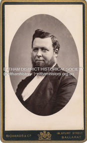
... to the records of assessable rates levied by the Eltham District Road... to the records of assessable rates levied by the Eltham District Road ...Photographer: Richards & Co. Portrait Parlours operated from 19 Sturt Street, Ballarat from 1881-1921 but with "Under Royal Patronage" appears to be 1881-1885. Phillip Shillinglaw was born Melbourne, August 7, 1842. He married Sarah Ann Kidd in Heidelberg, Victoria, February 28, 1872. In 1881 Phillip and Sarah and their small family moved to Eltham and made home in what was later to become known as Shillinglaw Cottage but which Phillip named 'Wattle Brae'. Shillinglaw Cottage is significant to Eltham’s local history. It is one of the earliest known buildings still in existence. Records suggest that the cottage was built circa 1859 by a man named Cochrane, believed to be Thomas Cochrane, in conjunction with George Stebbings though it is not known what Stebbings’s contribution was. It is believed Stebbings owned the cottage between 1874 and 1888. According to Margaret Ball’s (2017) book Shillinglaw Family of Eltham 1660-2007, Thomas Cochrane and family lived there from 1867 to 1874 however this is contrary to the records of assessable rates levied by the Eltham District Road Board, established in 1858, which shows Cochrane was the owner occupier (in Little Eltham) of approximately 25 acres of cultivated land and 25 acres of pastureland upon which a hut was sited in 1860. It is suspected that George Stebbings may have acquired the property from Cochrane in 1874 as it is noted that he had a tenant for a period, James Rossiter, who was the editor for the Evelyn Observer in Kangaroo Ground in 1874 (LATE SHIRE OFFICE AT KANGAROO GROUND (1934, February 16). Advertiser (Hurstbridge, Vic. : 1922 - 1939), p. 5. Retrieved February 25, 2022, from http://nla.gov.au/nla.news-article56743657). In 1881 Phillip Shillinglaw became the ratepayer for the cottage though Stebbings retained ownership until 1888 at which time it was transferred to Shillinglaw. CARTE-DE-VISITE (cdv) 1857-1890 Cartes-de-visite (cdv's) are the most common form of photograph from the nineteenth century, generally measuring two and a half inches by four and an eighth inches (6.3 x 10.5 cm) when mounted, sepia toned, mounted on a card which was generally printed with the photographer's name and address on the back or beneath the portrait. - Frost, Lenore; Dating Family Photos 1850-1920; Valiant Press Pty. Ltd., Berwick, Victoria 1991marg ball collection, shillinglaw family photo album 1, phillip shillinglaw (1842-1914), 1881-1885, 1885, richards & co. photographers 19 sturt st ballarat -
 Eltham District Historical Society Inc
Document, Russell Yeoman, Tour of Historic Buildings and Locations, 1978
... it was the first meeting place of the Eltham District Road Board in 1856... it was the first meeting place of the Eltham District Road Board in 1856 ...Self guided heritage tour information produced by the Shire of Eltham Historical Society for 1978 Eltham Community Festival of 36 locations each numbered on accompanying map. Locations and detail provided current to 1978: 1. ELTHAM SHOPPING CENTRE Whilst very little remains in the centre of historical importance, this area has interest as the "village" which developed over many years following the opening of the railway from Melbourne in 1902. Previously the shopping centre had been spread out over a long length of Main Road to the south. Shops have been continuously demolished or remodelled and the majority of buildings date from the 1950's or later. The recently erected Post Office replaced the "old" Post Office opened on the same site only in 1958. 2. WOOLWORTHS ELTHAM VILLAGE Part of the site of this modern shopping development was occupied by the former Eltham Shire Offices and Hall. The hall was paid for by public subscription whilst the Council raised a loan for the offices. The combined building was opened in 1941. It served as office and Council meeting place until 1965 and as the hall until its demolition in 1970. 3. ELTHAM WAR MEMORIAL The complex of buildings adjoining the present Shire Offices were financed by public subscription as a Memorial following World War II. Their construction and for many years their operation was organised by the now disbanded Eltham War Memorial Committee. The original buildings were the; Infant Welfare Centre, Children’s Library (now War Memorial Hall and Dental Clinic) and Kindergarten. In later years the Elderly Citizens Club was built at the rear. 4. ELTHAM SHIRE OFFICES These offices were opened in 1965 and extended in 1971 to provide additional office accommodation and the Eltham Library. They represent the last of a long line of offices and meeting places of the Eltham Shire Council and its predecessor the Eltham District Road Board. The building occupies the former site of Shillinglaw Cottage. The three tall cypress trees which stood in front of the Cottage have been retained as a feature of the office surrounds. 5. OUR LADY'S CHURCH AND SCHOOL The Catholic Church and School complex opposite the Shires Offices shows a number of stages in the development of Eltham township. The recently constructed church adjoins its predecessor (now the parish centre). Many years ago the Catholic Church was located opposite Wingrove Park and the present central site follows the northerly drift of the township. 6. SHILLINGLAW COTTAGE The Cottage was built in 1859 by George Stebbing, a local builder who was responsible for a number of other prominent buildings in the area. Its removal from the site of the Shire Offices and re-erection on the present site was financed by public subscription. It is built of handmade bricks laid in Flemish Bond with an unusual design featuring burnt "leader" bricks over the whole facade. The Cottage is occupied by Eltham Fleececrafts and will be open during the Festival and at other times during weekends. It is classified by the National Trust. 7. RAILWAY BRIDGE The timber trestle bridge over the Diamond Creek was built in 1901. Whilst all of its timbers have been replaced at various times over the years the only change to its character has been the addition of pylons and wiring for electric trains in 1923. It is one of very few similar bridges remaining in the metropolitan area. In 1976 a proposal to replace the bridge with an earth embankment and large culvert pipes was abandoned following community protests. The bridge, however, remains under threat because of the necessity for future deuplication of the railway line. 8. ELTHAM CENTPAL PARK The area between the railway and the creek has for many years been used as a park which included Eltham' s main football oval. The access road, Panther Place is named after Eltham's team playing in the Diamond Valley League. In recent years a large area extending to Bridge Street and locally known as the Town Park has been landscaped and added to the area. The excellent blending of the park with the natural landscape of the creek valley has earned a National Trust Landscape Classification. 9. OLD BAKERY On the southern corner of York Street and Main Road is an old house with a shop front which was for many years the local baker's shop. The brick bakery at the rear is of somewhat later vintage than the house. 10. BRIDGE STREET CUTTING Before reconstruction of Main Road this intersection had deep cutting embankments on all four corners, forming a distinctive feature of the entrance to Eltham. Roadworks and private development have levelled the land on the low side of the road. A memorial to the Eltham soldiers of World War I which was located at the north-western corner is now situated at the Eltham R.S.L. 11. HILLTOP MILK BAR For many years this was the site of the Eltham Post Office under the control of the Hunniford family and later their descendants the Burgoynes. It was transferred to this site in 1855, although at that time the building apparently fronted Bridge Str e et. The site contained Eltham's first telephone exchange. The post office was relocated in 1954 but the shop was operated until recently by the Burgoyne family who still own the surrounding land. 12. UNITING CHURCH and former C.B.A. BANK The former Methodist Church was built in 1880 by George Stebbing. The Sunday School extension was built in 1929 and there have been more recent extensions. The adjoining opportunity shop was built as a bank in 1874 and purchased by the Methodist Church in 1954. 13. R.S.L. HALL, TELEPHONE EXCHANGE These relatively recent buildings occupy the site of a row of shops forming part of the early ribbon of business development along Main Road. In front of the R.S.L. building is the World War I Memorial relocated from the corner of Bridge Street and Main Road. 14. ELTHAM COMMUNITY CENTRE Australia's first mudbrick "community building" was opened in April this year. Part of the site of the building was purchased in 1856 by Henry Dendy (of Brighton fame). At the rear of the land near the creek was a steam flour mill whilst Dendy's house was at the Main Road frontage of the land. His purchase totalled about 2 Ha (5 acres) and included land on the opposite side of Maria Street (Main Road). Dendy became a prominent member of the Eltham community and served one term as President of the Eltham District Road Board. In 1867 Dendy sold his land and business to William Ford of Malmsbury and shifted to Walhalla. The avenue of trees leading past the Community Centre to the creek may well have bordered the track to the mill. 15. ELTHAM HOTEL The original part of this hotel was built in 1927 following the burning of the former Watson's Eltham Hotel on the same site. The car park on the opposite side of Main Road was also the site of a hotel variously known over the years as; the Fountain of Friendship, the Fountain and the Evelyn Arms. As the Fountain of Friendship it was the first meeting place of the Eltham District Road Board in 1856. 16. ST. MARGARET'S CHURCH, PITT STREET In 1860 Henry Dendy was appointed Chairman of a committee to establish a church of England in Eltham. He donated part of his land in Pitt Street and in 1861 the church was opened. It was built by George Stebbing and remains in a well preserved state today. Th adjoining old vicarage is now named Dendy Hou se. A new mudbrick church hall is under construction on the site. The church and Dendy House are now listed on the Register of Historic Buildings. 17. NO. 86 PITT STREET Cottage built by George Stebbing and believed to be his home for some years in the 1850s. 18. LIVING AND LEARNING CENTRE The house was built in the 1850s with the kitchen at the front being added about 40 years later. By the creek below the house a number of early Eltham industries were located. These included a tannery and a brewery. 19. ELTHAM COURT HOUSE A Court of Petty Sessions was established in Eltham in 1858 and the present building dates from 1860. It is the oldest public building remaining in Eltham. In its early days the building was used as the meeting place and office of the Eltham District Road Board and as an overflow classroom for the local school. The Court House has been classified by the National Trust. The citation states that it is an example of the simple form of early brick Court House with gabled roof and porch. 20. LANDS DEPARTMENT OFFICE This building is the former police station and is probably of about the same age as the Court House. The lockup at the rear has been demolished but the old stables remain as garages. A licence was first granted for a police station at Eltham in 1856. 21. JARROLD COTTAGE The old Cottage opposite Dalton Street was formerly owned by the Jarrold family. Early records indicate that this was the building leased from the Jarrolds as a temporary police station prior to construction of the building on the corner of Brougham Street. The small building on the corner of the property was used as a boot repairer's shop. The elevated studio at the rear is a more recent construction by the present owners. 22. STATE SCHOOL RESIDENCE Erected in 1891 23. WINGROVE COTTAGE This building fills an important place in the history of Eltham and is now used as a medical clinic. It was built in 1858 for Charles S. Wingrove who was Secretary to the Eltham District Road Board and Shire Council from 1858 to 1904. During part of this period he was also Shire Engineer and was Secretary to the Heidelberg Road Board. The house was used as the office of the Board and Council for many years. Wingrove is buried in the cemetery at St. Helena. 24. WINGROVE PARK The parkland opposite Wingrove Cottage has been named after Charles Wingrove. The old Manna Gums are an outstanding feature of the park. 25. ELTHAM FRI.MARY SCHOOL NO. 209 The school first opened in the slab building in 1855 and operated from the present site since 1857. The oldest part of the present school is the stone building erected in 1876. The first school teacher, David Clark remained at the school until 1888. This school is the government township and has always been known as the Eltham School. An earlier school (no.371) known as Little Eltham School operated in Swan Street from 1853 to 1872. 26. "SHOESTRING" This house was built for school teacher David Clark. It has been extensively extended in recent years but the extensions do not detract from the character of the older part of the building. 27. ELTHAM CEMETERY The cemetery contains the graves of many of the district's pioneers . 28. MONTSALVAT This unique complex of buildings was commenced in 1935 by the late Justus Jorgensen and its development has extended over many years. Montsalvat has exerted a significant impact on Eltham The earth and stone construction of many of the buildings has influenced local architecture to a great extent and it has served as a "nerve centre" of the local artistic community. Montsalvat is open to the public for a small charge. 29. MAIN ROAD BRIDGE This location has been the main crossing of Diamond Creek since the earliest days of settlement. The present concrete bridge was erected in 1925 .and was preceded by a number of timber bridges. 30. ELTHAM LOWER PARK This park, being an unusually large flat area for Eltham, was originally the local racecourse. Horse races were held here from 1855 and the area was gazetted as a reserve for a racecourse and recreation reserve in 1857. The park is well known as a venue for school "bird days" and more recently as the site of the Diamond Valley Railway. This miniature railway features scale models of modern and old locomotives and rolling stock and has operated on this site since 1961 . Before that the railway operated at Chelsworth Park, Ivanhoe. 31. FALKINER HOUSE Frederick Falkiner was one of the earliest settlers in the Eltham township area and occupied a substantial leasehold prior to the first land sales. Early records show that Falkiner was the subject of a number of complaints from his neighbours but he has nevertheless been considered a prominent enough citizen to have a street named for him. This house was the home of Evelyn (Ely) Falkiner a member of Frederick's family. 32. WEST HOUSE Behind the large house on the hill is an early house built by the West family. This was relocated from a site near the front of the land by the present owner Mr. Fabbro. 33. FALKINER HOUSE This very old house is believed to have been the home of Frederick and may have been Eltham's first post office. Falkiner was the first post master for a short period. in 1854/55. 34. WITHERS HOUSE This house was the home of famous artist Walter Withers who shifted here from Heidelberg in 1903. 35. ELTHAM HIGH SCHOOL This school celebrated its jubilee this year, having commenced as the Eltham Higher Elementary School 50 years ago. 36. DIAMOND CREEK FOOTWAY If returning from the High School to the town centre the footpath by the bank of the Diamond Creek provides a pleasant route to finish your walk. The creek is a major tributary of the Yarra River. Together with its own major tributaries Arthurs Creek and Running Creek it commences on the southern slopes of the Dividing Range at Kinglake. It gives the name Diamond Valley to an area extending well beyond its actual drainage catchment.Recognition of the significance of various landmarks to the history of the Eltham community as of 1978‘shoestring’, 1978, bridge street cutting, burgoyne store, c.b.a. bank, diamond creek trail, eltham cemetery, eltham central park, eltham community centre, eltham community festival, eltham court house, eltham festival, eltham high school, eltham hotel, eltham lower park, eltham primary school, eltham railway trestle bridge, eltham shire offices, eltham shopping centre, eltham state school no. 209, eltham village, eltham war memorial, falkiner house, heritage trail, hilltop milk bar, jarrold cottage, lands department office, living, living and learning centre, main road bridge, montsalvat, old bakery, our eltham artistic recollections, our lady help of christian’s church, our lady help of christian’s primary school, pitt street, post office, r.s.l. hall, shillinglaw cottage, st margaret’s church, state school residence, stebbing cottage, telephone exchange, uniting church, west house, wingrove cottage, wingrove park, withers house, woolworths -
 Eltham District Historical Society Inc
Photograph, Liz Pidgeon, Public Records Office Victoria (PROV) visit to Eltham Justice Precinct, 20 Apr 2018
... Eltham District Road Board... Road Board, which was established in 1856. The initial rate... Road Board, which was established in 1856. The initial rate ...The original Shire of Eltham was founded in 1871. Prior to its founding, the district was managed by the Eltham District Road Board, which was established in 1856. The initial rate assessment commenced in 1857 for the year ending October 14, 1858. The honour of being recorded with the first assessment went to a farm of 110 cultivated acres at Lower Plenty, owned by John Porter and occupied by Albert Baines. It was assessed at 6d/acre providing for a rate income of £2 15s. In July 2017, officers at Nillumbik Shire Council discovered some early Eltham Road District Assessment books and donated them to the Eltham District Historical Society. The seven volumes were the district’s first six years of rate assessments. This was a unique and significant record of early settlers in the pre-Shire of Eltham. They immediately became one of the oldest and most valuable items in our collection. An article on page 5 in the Eltham and Whittlesea Shires Advertiser, Friday, 21 November, 1941 titled: ‘District’s Early History‘ states: “The first rate book which is still in existence at the Shire Office is for the year ending October 14, 1858 and is probably the best record possible to indicate the development of the district. At the time properties were rated as follows: Cultivated land. 6d. per acre; pasture land, 1d. per acre: estimated annual value of buildings, etc., 6d in the (pound). The total amount of rate recorded for the year was £153/14/8. Properties were described as being situated at Lower Plenty, Yarra Yarra, Eltham, Lower Eltham, Kangaroo Ground, Yarra Flats, Diamond Creek and the Yarra.” Given the precious nature of this collection, priority was given to digitise the rate books and place them in suitable archival storage to minimise further handling. Subsequent discussion amongst our Collections team arrived at the conclusion that the most appropriate home for this valuable record was the Public Record Office Victoria (PROV), the archive of the State Government of Victoria and who are charged with archiving and caring for all Government related records. An approach was made to PROV who confirmed these records would complete their collection of rate assessment books for Eltham. At a small ceremony held Friday, April 20 at the Local History Centre, Eltham, members of the Society and our Collections team, along with Ms. Vicki Ward, MP for Eltham, presented the seven volumes for 1858-1863 along with the complete set of digital files to Mr. David Taylor, Community Archives Manager and Mr. Charlie Farrugia, Senior Collection Advisor, Public Record Office Victoria.Born Digitalassessment ledger, donation, eltham courthouse, eltham road district, local history centre, public records office victoria (prov), rate books, eltham district road board -
 Eltham District Historical Society Inc
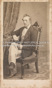
Photograph, Louis Buvelot, Possibly Phillip Shillinglaw, 1865
... to the records of assessable rates levied by the Eltham District Road... to the records of assessable rates levied by the Eltham District Road ...Famous Swiss landcape painter Louis Buvelot came to Melbourne in 1864 and set up a portrait photography studio which he operated for one year only in 1865. This photograph is believed to be the oldest photo in the Shillinglaw Family Album collection. It is believed that the subject is a young Phillip Shillinglaw, without beard, at age 22 or 23. Phillip Shillinglaw was born Melbourne, August 7, 1842. He married Sarah Ann Kidd in Heidelberg, Victoria, February 28, 1872. In 1881 Phillip and Sarah and their small family moved to Eltham and made home in what was later to become known as Shillinglaw Cottage but which Phillip named 'Wattle Brae'. Shillinglaw Cottage is significant to Eltham’s local history. It is one of the earliest known buildings still in existence. Records suggest that the cottage was built circa 1859 by a man named Cochrane, believed to be Thomas Cochrane, in conjunction with George Stebbings though it is not known what Stebbings’s contribution was. It is believed Stebbings owned the cottage between 1874 and 1888. According to Margaret Ball’s (2017) book Shillinglaw Family of Eltham 1660-2007, Thomas Cochrane and family lived there from 1867 to 1874 however this is contrary to the records of assessable rates levied by the Eltham District Road Board, established in 1858, which shows Cochrane was the owner occupier (in Little Eltham) of approximately 25 acres of cultivated land and 25 acres of pastureland upon which a hut was sited in 1860. It is suspected that George Stebbings may have acquired the property from Cochrane in 1874 as it is noted that he had a tenant for a period, James Rossiter, who was the editor for the Evelyn Observer in Kangaroo Ground in 1874 (LATE SHIRE OFFICE AT KANGAROO GROUND (1934, February 16). Advertiser (Hurstbridge, Vic. : 1922 - 1939), p. 5. Retrieved February 25, 2022, from http://nla.gov.au/nla.news-article56743657). In 1881 Phillip Shillinglaw became the ratepayer for the cottage though Stebbings retained ownership until 1888 at which time it was transferred to Shillinglaw. Photographer: Louis Buvelot Swiss landscape painter and portrait photographer, settled in Melbourne in 1864, admired by the artists from the Heidelberg area such as Tom Roberts and Arthur Streeton who bestowed him with the accolade of 'Father of Australian painting’. In the 1870s, his work increasingly drew elements from Australian landscape such as the bush land in works like Lilydale (1878) and Bush Track. "Louis Buvelot :: biography at :: at Design and Art Australia Online." Daao https://www.daao.org.au/bio/louis-buvelot/biography/. Accessed 9 Mar. 2023. On arriving in Melbourne in February 1865 Buvelot bought a photographer's studio at 92 Bourke Street East and took portraits for a year. In 1866 he moved to 88 La Trobe Street East and resumed his painting while Caroline-Julie gave French lessons to help Buvelot to establish himself as an artist in Melbourne. "Biography - Abram-Louis Buvelot." Australian Dictionary of Biography https://adb.anu.edu.au/biography/buvelot-abramlouis-3132. Accessed 2 Dec. 2022. CARTE-DE-VISITE (cdv) 1857-1890 Cartes-de-visite (cdv's) are the most common form of photograph from the nineteenth century, generally measuring two and a half inches by four and an eighth inches (6.3 x 10.5 cm) when mounted, sepia toned, mounted on a card which was generally printed with the photographer's name and address on the back or beneath the portrait. - Frost, Lenore; Dating Family Photos 1850-1920; Valiant Press Pty. Ltd., Berwick, Victoria 1991marg ball collection, shillinglaw family photo album 1, 1865, l. buvelot photographer, louis buvelot, phillip shillinglaw (1842-1914), unknown -
 Eltham District Historical Society Inc
Photograph - Digital Photograph, Marguerite Marshall, Eltham Lower Park, 20 April 2008
... , the newly formed Eltham District Road Board petitioned the Surveyor..., the newly formed Eltham District Road Board petitioned the Surveyor ...Originally a race course, the park has brought the community together with a variety of activities. Published: Nillumbik Now and Then / Marguerite Marshall 2008; photographs Alan King with Marguerite Marshall.; p45 Once used for horse racing, which attracted visitors from Melbourne, the Eltham Lower Park has brought the community together with a wide range of activities. Horse riding is now enjoyed as a recreation in the park as are other sports. The park also includes the Diamond Valley Railway miniature trains and a sanctuary for the rare and vulnerable Eltham Copper Butterfly. Eltham Lower Park, with other parks, forms an almost continuous green band from Eltham’s centre, along the Diamond Creek to the Yarra River.1 Before European settlement the Wurundjeri people met on this land, particularly at the junction of the Diamond Creek with the Yarra River, which they called Birr-arung. This is commemorated by the sculpture, Not just a Pretty Place by Aleks Danko, winner of the 2000 Nillumbik Art in Public Places Award. The first European to settle here was probably Henry Foley, who in 1841 used it as part of his pastoral run. Foley sold his leasehold to Joseph Wilson in 1845, who soon after sold it to Frederick Falkiner. During the 1840s the future park was part of a government square mile (2.6 sqkm) reserve, north of the Yarra, within the Parish of Nillumbik, later named Eltham. Soon the land was used for horse racing after nearby residents cleared ten acres (4ha) in the early 1850s. A three-quarter of a mile (1.2km) race secured the winner the £10 Publican’s Prize. In response to popular demand, the newly formed Eltham District Road Board petitioned the Surveyor General of the Colony of Victoria, in 1856, for 36 acres (14.6ha) of crown land for a racecourse and recreation. By 1858 the Eltham races had become an institution. ‘Many skirmishes occurred and the way home was paved with temptation, with sly-grog for sale.3 In the early 1870s, two jockeys were sons of the police officer in charge of the Eltham Police Station, Miles S Lyons. Another ten acres (4ha) was added to the area in 1866 and 12 acres (4.8ha) – Hohnes Hill – in 1870. In 1866, two acres (0.8ha) on the creek banks became an animal pound with William Walsh the pound keeper in 1870, but this was later incorporated into the park. By 1877 the area was called a public park but horse racing and training continued into the 1920s. In the mid-1900s trotters were trained on a circuit road. In 1953 the Eltham Pony Club was established and used a cross-country course on Hohnes Hill. From the mid 1950s the club held the Eltham Easter Fair at the park, later to include a procession along Main Road from the town centre to the park. The park also attracted picnic parties and campers from the inner suburbs as did Wingrove Park, and businesses catering for visitors, sprang up on the opposite side of Main Road. Bus-loads of school children visited the park for Gould League bird days in the 1960s. In 1979 the Eltham Shire Council bought Lenister Farm, linking the park with the Yarra River. The Lenister Farm wetland includes a bird hide, viewing platform and interpretive signs.5 Pioneer Henry Stooke, later Road Board chairman, bought the 11 acres (4.5ha) - later to become Lenister Farm - from the Crown in 1862. Stooke never lived on this site and the two houses at Lenister Farm were built in the 20th century. Since its formation in 1871, the Council has controlled this crown land, which it named Eltham Park. But in the 1920s Eltham Council bought land near the town centre for a park, which it named Eltham Central Park. To avoid confusion the Council renamed Eltham Park, Eltham Lower Park. Since 2004 the Yarra footbridge has linked the park with the Yarra Valley Metropolitan Park and the Main Yarra Trail.This collection of almost 130 photos about places and people within the Shire of Nillumbik, an urban and rural municipality in Melbourne's north, contributes to an understanding of the history of the Shire. Published in 2008 immediately prior to the Black Saturday bushfires of February 7, 2009, it documents sites that were impacted, and in some cases destroyed by the fires. It includes photographs taken especially for the publication, creating a unique time capsule representing the Shire in the early 21st century. It remains the most recent comprehenesive publication devoted to the Shire's history connecting local residents to the past. nillumbik now and then (marshall-king) collection, eltham lower park, eltham park -
 Eltham District Historical Society Inc
Photograph - Digital Photograph, Alan King, Cameron family graves, Kangaroo Ground Cemetery, Eltham-Yarra Glen Road, Kangaroo Ground, 28 January 2008
... establishing the Eltham District Road Board. Many of these families... establishing the Eltham District Road Board. Many of these families ...Six year old Judith Furphy was the first person known to have been buried at Kangaroo Ground Cemetery in May 1851. The cemetery is situated on an ancient river bed with exposed Nillumbik sands. The rest of the district is formed from black volcanic soil which was hard to dig. According to local historian Mick Woiwod (deceased) the site may have been a burial ground for the local Wurundjeri people as the exposed softer sands were always their prefered camping sites. The Hon. Ewen Hugh Cameron who lived at Pigeon Bank and was the Member for Evelyn for 40 years (1874-1914) was buried here in 1915. Published: Nillumbik Now and Then / Marguerite Marshall 2008; photographs Alan King with Marguerite Marshall.; p39 The Wurundjeri people might have buried their dead on the site of the Kangaroo Ground Cemetery, according to local historian Mick Woiwod. Kangaroo Ground was a premier hunting ground, but camping on the black volcanic soil would have been uncomfortable. Unlike most of Kangaroo Ground, its cemetery, on an ancient river bed, comprises a rare exposure of Nillumbik sands – always the preferred campsite for Aboriginal people. The cemetery area is the only place where the soil was soft enough to dig a grave easily.1 Six-year-old Judith Furphy was the first person known to have been laid to rest at the Kangaroo Ground Cemetery. She died on May 17, 1851, from a chill caught by resting on wet grass. Local Andrew Ross wrote ‘..no public burying place existed nearer than Melbourne. The case being considered urgent, a general meeting of the settlers took place on the evening of the 17th……. The result was the selection of unoccupied crown land …….which was subsequently granted by Government for a public cemetery.’2 Judith was buried the next day on May 18. Her grave was marked by the trustees with a plaque, which unfortunately states nine years old, when she was probably only six. Judith came from an illustrious family. Her brother, Joseph, was the author of Such is Life and other works. Another brother, John, developed and manufactured the famous Furphy water cart, which distributed water to World War One soldiers along with the latest rumours. Hence the name Furphy entered the Australian idiom, as synonymous with ‘rumour’. Judith’s father Samuel helped build the first Kangaroo Ground church school. Inside, near the entrance of the cemetery, on Yarra Glen Road, stand a rotunda and a water tank. Occasional benches invite mourners to pause and remember. The gate with wrought iron and brick supports, bears the inscription ‘Erected by Sir Ewen and Lady Cameron in memory of their daughter, Flora Margaret’. These are only two of the famous people connected with this cemetery. The Hon. Ewen Hugh Cameron JP and MLA from 1874 to1914, who lived at Pigeon Bank, Warrandyte Road, was buried here in 1915. Unrelated, but with the same name, was Sir Ewen Cameron who had been Minister for Health and was laid to rest there in 1964. Sir Herbert Gepp, a leading industrialist and the former owner of Garden Hill, at Yarra Glen Road, was buried there in 1954.3 Many of the more imposing tombstones belong to the earlier graves. Unfortunately bushfires have cracked several. But this adds to the melancholy attractiveness of the cemetery, graced by some beautiful eucalypts, cypress and pines. Early pioneering families represented at the cemetery include Armstrong, Barr, Bell, Harkness, Jardine, Johnston, Rogerson, Stevenson, Thomson and Walters. Armstrong and Bell were among the first families to come to the district and Stevenson owned the district’s first sheep station. It took in much of present day Christmas Hills, which was the name he gave his sheep station. Harkness was the first to suggest a Kangaroo Ground school be built, and one of the first to suggest establishing the Eltham District Road Board. Many of these families leased pastoral land before the mid-century and bought land when it came on sale in 1849. In the cemetery’s early days sections were devoted to the major Christian denominations (mainly the Protestant) and one section was set aside for ‘other’ or ‘non-believers’. However in modern times burial plots have not been placed in areas according to religious beliefs.This collection of almost 130 photos about places and people within the Shire of Nillumbik, an urban and rural municipality in Melbourne's north, contributes to an understanding of the history of the Shire. Published in 2008 immediately prior to the Black Saturday bushfires of February 7, 2009, it documents sites that were impacted, and in some cases destroyed by the fires. It includes photographs taken especially for the publication, creating a unique time capsule representing the Shire in the early 21st century. It remains the most recent comprehenesive publication devoted to the Shire's history connecting local residents to the past. nillumbik now and then (marshall-king) collection, kangaroo ground, eltham-yarra glen road, agnes bell cameron, agnes cameron (nee bell), cameron family, edward aubrey haughton, eugene cameron, evelyn florence cameron, ewen hugh cameron, gravestones, jane armstrong, jane bell, jessie agnes haughton (nee cameron), jessie cameron, john donald cameron, kangaroo ground cemetery, neville cameron, simon armstrong, vera cameron, william bell armstrong, wurundjeri -
 Eltham District Historical Society Inc
Photograph - Digital Photograph, Alan King, Kangaroo Ground General Store, Eltham-Yarra Glen Road, 28 December 2007
... , on the same site, was the meeting place for the Eltham District Road..., on the same site, was the meeting place for the Eltham District Road ...The present store was built circa 1900 to replace another which had been destroyed by fire in 1898, which had replaced a predecessor on the opposite side of the road in 1865. The store was also used as a post office until early 2000s. The general store is historically significant because it has a long association with Kangaroo Ground and has been an important centre of community life for more than 120 years - Council meetings used to be conducted in the front room of the store at a time when Kangaroo Ground rivalled Eltham as the major centre of the Shire. The general store is historically and aesthetically significant as one of a group of three well preserved public buildings in the Kangaroo Ground hamlet and as a major heritage component of Kangaroo Ground which was one of the earliest settled areas of the Shire and which has the character of an English village rather than an Australian settlement. Covered under Heritage Overlay, Nillumbik Planning Scheme. Published: Nillumbik Now and Then / Marguerite Marshall 2008; photographs Alan King with Marguerite Marshall.; p77 Today the general store is an uncommon form of trade but the one at Kangaroo Ground continues a long tradition of friendliness and service. For more than 100 years it has been a centre of community life. In the settlement’s early days a previous general store, on the same site, was the meeting place for the Eltham District Road Board, precursor to the Eltham Shire Council. For years Kangaroo Ground rivalled Eltham as the shire’s major centre. It developed very differently from the rest of the shire as its rich soil attracted prosperous Presbyterian Scots who had large agricultural properties.1 The present store was built to replace another one, which had burnt down in 1898, after replacing a predecessor on the other side of the road in 1865. The store retains its outward character and its cellar, although inside it has changed considerably. It now includes a café and offers local produce, milk bar products, grocery items, gas and other fuel. Until early this century the store was also used as a post office. Kangaroo Ground’s first postmaster was Andrew Ross, who first operated from the school opposite, then from his hotel next to the present tennis court site. The first postmaster at this store was Edward Weller, followed in 1868 by James Anderson. At that time a mail coach ran three times a week between Eltham and Woods Point through Kangaroo Ground, Yarra Flats, Healesville, Fernshaw, Marysville and Matlock. Some early postmasters were Rodger, McLaughlin, Greenway and Burns.2 Burns was the only postmaster operating from the store. The others operated from Andrew Ross’s hotel. The mail service improved in 1892 when coaches ran from Melbourne to Queenstown (now known as St Andrews) and changed horses at Kangaroo Ground twice daily. The only telegraph office in the district at that time was at the Kangaroo Ground Post Office. Telegrams to outlying areas such as Queenstown and Kinglake had to be sent by hand. A local resident in the early 1900s often rode his pony to deliver telegrams and was paid one shilling a mile porterage. The store has also contributed to the lighter side of Kangaroo Ground life. During the years that Con Wraight owned the store, between 1906 and 1946, a new piano was needed for the Kangaroo Ground Hall, so monthly dances were held to raise money. When the piano was bought, a grand ball was held in the Kangaroo Ground Hall to celebrate the occasion and supper followed at Mr Wraight’s barn, cleaned especially for the occasion. Every New Year’s Eve, a Scottish piper would set off from between the store and the schoolhouse, playing his pipes, and march to Cameron’s Pigeon Bank homestead on the Kangaroo Ground-Warrandyte Road. Between 1914 and 1922, the store was a station for the Kangaroo Ground Bush Fire Brigade’s tanker. It consisted of a wooden barrel on a cart, fitted with a hand-pump, and stood on the side of the road outside the store. Joy Ness, who belonged to an early Kangaroo Ground family, moved here in 1940 and recalled her impressions of the store at that time: ‘It was a very dark shop stained in a dark colour and on the walls just below the ceiling hung hurricane lamps, ropes, kitchen utensils and other goods for sale. ‘Goods were weighed on a brass scale with weights, on which mothers also weighed their babies, because the nearest Infant Welfare Centre was at Greensborough. The bacon was cut with a hand slicer and later a pot-bellied stove warmed the store. Farmers and other locals used to gossip around it as they collected their daily mail. In those days the butter and cheese were kept in the cellar as no ice was delivered for cooling.’This collection of almost 130 photos about places and people within the Shire of Nillumbik, an urban and rural municipality in Melbourne's north, contributes to an understanding of the history of the Shire. Published in 2008 immediately prior to the Black Saturday bushfires of February 7, 2009, it documents sites that were impacted, and in some cases destroyed by the fires. It includes photographs taken especially for the publication, creating a unique time capsule representing the Shire in the early 21st century. It remains the most recent comprehenesive publication devoted to the Shire's history connecting local residents to the past. nillumbik now and then (marshall-king) collection, eltham-yarra glen road, kangaroo ground general store -
 Eltham District Historical Society Inc
Photograph - Digital Photograph, Alan King, Nillumbik Shire Offices, Greensborough, 30 March 2008
... and the Plenty River. From this committee arose the Eltham District Road... and the Plenty River. From this committee arose the Eltham District Road ...Nillumbik Shire Council transferred to the former Diamond Valley Shire Offices in Greensborough after municipal restructuing. The offices became the official Nillumbik Shire Council Offices on 16 October 1995. The former Shire of Diamond Valley Civic Centre or Shire Office building was officially opened on 26th February 1972. Archtiects were A.K. Lines, McFarlane & Marshall and it was built by L.U. Simon Pty Ltd, The Diamond Valley Shire had been created in 1964 from part of the City of Heidelberg. On December 15, 1994 the Shire of Nillumbik was established. Under the Council amalgamations imposed by the Kennett government, the Shire of Eltham, Shire of Diamond Valley and City of Heidelberg ceased to exist with the establishment of Nillumbik Shire Council and the City of Banyule.The new Nillumbik shire surrended the west riding from Eltham to Banyule but in place gained parts of the former Diamond Valley Shire which itself had been created in 1964 from parts of the City of Heidelberg. Three unelected and non-local Commissioners were put in place by the government bringing democracy into question by many members of the local community. The Commissioners determined to abandon the former Shire of Eltham offices located in Main Road, Eltham and in turn occupy the former Shire of Diamond Valley offices located at the boundary of the new shire with Banyule, in Civic Drive, Greensborough. In July 1996 the Commissioners sold the former Eltham Shire Offices and had them bulldozed leading to many years of communiity protest over the process and future development applications. The site has remained vacant ever since. Published: Nillumbik Now and Then / Marguerite Marshall 2008; photographs Alan King with Marguerite Marshall.; p43 It was the need for roads that led to this district’s first council. In 1853 a committee was formed to improve the rough roads, some in Kangaroo Ground being almost impassable in winter.1 The committee fundraised by voluntary levies and grants to improve in particular, the main road between Kangaroo Ground and the Plenty River. From this committee arose the Eltham District Road Board, in 1856, which was the precursor to the Eltham Shire Council. The Board’s first chairman was Kangaroo Ground farmer, John Barr. Secretary was the former committee’s secretary, Andrew Ross, Kangaroo Ground’s first school teacher, and founder of the district newspaper, The Evelyn Observer.2 Most of the board’s income came from a toll-house north of the Lower Plenty Bridge, which funded such projects as a road from Kangaroo Ground to the Caledonia Diggings. In 1871 the Shire of Eltham was proclaimed, with its boundaries the same as those of the Road Board, and Councillor A Donaldson of Kangaroo Ground was the first president. Eltham was at the southern tip of the shire, which extended north to Kinglake and east beyond Yarra Glen. In 1878, part of Kinglake was added to the shire, while the area east of Watts River, near Healesville was removed. In 1912, then again in 1958, the shire was further reduced. Yarra Glen, Steels Creek, Tarrawarra, parts of Healesville and Christmas Hills, were transferred to the Shire of Healesville. In 1972 a smaller area, at Kinglake, was transferred to the Shire of Yea, leaving 277 square kilometres in the Eltham Shire. Perhaps no other Victorian municipality has had so many meeting places. Although from 1858 to 1904, the council convened at the office in the home of Secretary Charles Wingrove, the board, and later the council, also met at other more central locations.3 The board moved from the Fountain of Friendship Hotel to the Eltham Courthouse, to the Kangaroo Ground schoolhouse. It then met at the Kangaroo Ground Hotel, which some considered put it in danger of interruptions by people ‘the worse for liquor’.4 In 1885 the council met at the hall on Mr J Donaldson’s land at Kangaroo Ground. After Wingrove’s retirement, the council rented space at the Kangaroo Ground General Store and Post Office. Then, in 1917, the council bought the former office of The Evelyn Observer, after its printing works transferred to Hurstbridge. In 1934, fire destroyed the shire office, which was temporarily relocated to the Kangaroo Ground home of Shire Secretary, Mr P J McMahon. In 1941, the shire office moved to a new building (which included a public hall) in Eltham, at the corner of Arthur Street and Main Road, where the Eltham Village Shopping Centre was eventually built. Growth required new offices, which opened in 1965, on the former Shillinglaw property in Main Road.5 In 1994, as part of municipal restructuring under the Jeff Kennett Liberal Government, most of the Eltham Shire formed part of the new Shire of Nillumbik. It joined with the north section of the Diamond Valley Shire and parts of the Healesville and Whittlesea municipalities. The Diamond Valley Shire had been created in 1964, from part of the City of Heidelberg. Turbulence followed Nillumbik Shire’s formation. Under the Commissioners the council transferred to the former Diamond Valley Shire offices in Greensborough, and the Eltham council offices were demolished. In March 1997 the first five-member Nillumbik Council was elected. But, in October 1998, the government suspended the council and appointed an administrator . Early in 1999, shire residents voted to increase councillors to nine: comprising five ward councillors and four shire-wide councillors. Elections were held in March 1999. Then, before the March 2002 elections, nine new wards were created.6 In 2008 these were reduced to seven. Today [2008] the council governs a varied population of more than 60,000 people living in townships and on bush properties in the green wedge.This collection of almost 130 photos about places and people within the Shire of Nillumbik, an urban and rural municipality in Melbourne's north, contributes to an understanding of the history of the Shire. Published in 2008 immediately prior to the Black Saturday bushfires of February 7, 2009, it documents sites that were impacted, and in some cases destroyed by the fires. It includes photographs taken especially for the publication, creating a unique time capsule representing the Shire in the early 21st century. It remains the most recent comprehenesive publication devoted to the Shire's history connecting local residents to the past. nillumbik now and then (marshall-king) collection, greensborough, nillumbik shire council offices, civic drive -
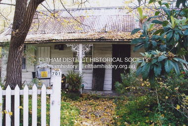 Eltham District Historical Society Inc
Photograph, Fay Bridge, Former Jarrold Cottage and Bootmaker's Shop, 701 Main Road, Eltham, n.d
Situated originally on the corner of the Dalton Street road reserve west of Main Road (now present-day Wingrove Park Trail), the former Jarrold Cottage (White Cloud) was purchased by Lena Skipper following Thekla Jarrold's death in 1943. It was built by William Jarrold in the early 1850s and was here that he married Hannah Coleman in 1856. The Bootmaker's shop was built by Thekla Jarrold in 1930 for use by her friend, John Clark, a local photographer who had boarded with the Jarrold family since about 1910. In 1930 he changed profession to a bootmaker and leather worker. The shop is one of only three remaining early 20th century shops in what was Little Eltham, the others being present-day San Antionio Barber Shop at 820 Main Road and Cafe Zen Den at 736 Main Road.fay bridge collection, bootmaker's shop, eltham, jarrold cottage, main road, shops, white cloud cottage, wingrove park trail -
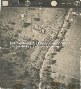 Eltham District Historical Society Inc
Photograph - Aerial Photograph, Main Road, Eltham near Leanne Drive, 2 Jul. 1951
... Photo Country Roads Board Eltham Main Road Road widening Leane ...Not originally catalogued in Shire of Eltham Archives but from the same series of photos taken for Country Road Board study of Main Road wideningshire of eltham archives, aerial photo, country roads board, eltham, main road, road widening, leane drive, 1951-07 -
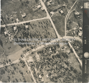 Eltham District Historical Society Inc
Photograph - Aerial Photograph, Main Road, intersection Grand Boulevard and Panorama Avenue, Lower Plenty / Montmorency, 2 Jul. 1951
... Photo Country Roads Board Eltham Main Road Road widening 1951-07 ...Not originally catalogued in Shire of Eltham Archives but from the same series of photos taken for Country Road Board study of Main Road wideningshire of eltham archives, aerial photo, country roads board, eltham, main road, road widening, 1951-07, airlie road, ambulance station, beleura grove, grand boulevard, looker road, lower plenty, montmorency, panorama avenue -
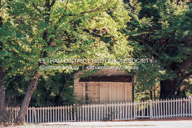 Eltham District Historical Society Inc
Photograph (Item) - Print, Craig Price, Old Bootmakers Shop in Main Road, Eltham - Eltham's history worth preserving, 1988
701 Main Road, Eltham Situated originally on the corner of the Dalton Street road reserve west of Main Road (now present-day Wingrove Park Trail), the former Jarrold Cottage (White Cloud) was purchased by Lena Skipper following Thekla Jarrold's death in 1943. It was built by William Jarrold in the early 1850s and was here that he married Hannah Coleman in 1856. The Bootmaker's shop was built by Thekla Jarrold in 1930 for use by her friend, John Clark, a local photographer who had boarded with the Jarrold family since about 1910. In 1930 he changed profession to a bootmaker and leather worker. The shop is one of only three remaining early 20th century shops in what was Little Eltham, the others being present-day San Antionio Barber Shop at 820 Main Road and Cafe Zen Den at 736 Main Road. Craig Price 1988 Entrant No. 148 Ref: Series 34, Items 37, 38, 109, 110 SHIRE OF ELTHAM COMMUNITY PHOTOGRAPHIC SURVEY Photography is an artform which many of us practice, sometimes purely for artistic pursuit, sometimes to record the people and events in our lives. In 1988, as part of a local Bicentennial project, the Shire of Eltham conducted the Eltham Community Photographic Survey. Up to 100 entries were to be selected by a panel of photographers for entry into the Eltham Photographic Survey Exhibition. Entries had to be submitted by May 13, 1988. Entrants whose images were selected for the exhibition were contacted and requested to further submit an entry form providing entrant’s name, area of residence, age, and proposed captions. These details were then used to produce labels for the exhibition mounts. Where negatives had not been supplied, these were requested to support the display of printed enlargements mounted on 10” x 8” cardboard. The mounted prints were made available post exhibition for sale at $8.50 each for colour prints and $7.00 for B&W prints. Residents in the Shire were invited to collect a free roll of film and take a photograph of what they either liked or did not like about the area. A total of 160 entrants submitted multiple entries for the exhibition. Of those selected for exhibition, entrants ranged in age from 9 to 70 years. All custom colour and black and white printing for the exhibition was completed by Wattle Studios of Eltham. The Eltham Photographic Survey was jointly auspiced by the Shire of Eltham and Wattle Studios, of 953 Main Road, Eltham. The project was greatly assisted by: • David McRitchie, Media Studies Lecturer Victoria College, Rusden Campus. • Ian and Annette Toohill of Wattle Studios • Tracy Naughton, Eltham Community Arts Officer • Neville Emerson Pty. Ltd. • Superior Press, Eltham • Kodak Australasia Pty. Ltd. • Agfa Gevaert Ltd. • Townsend Colourtech Pty. Ltd. • The Australian Bicentennial Authority • Eleanor Bowers, Secretary, Eltham Arts Council The exhibition was placed on display in the Woolworths Arcade, Eltham between Monday June 6th and Saturday June 11, 1988. It was also intended to hold the exhibition at a venue in the Shire’s North Riding from Monday, June 20 to Friday June 24. It was then displayed at the Were Street Theatre, Montmorency from Friday, June 24 to Thursday, July 7. Series 34: Eltham Community Photographic Survey 1988 - Prints & Documentation Series consists of 117 photographs of Shire scenes taken by members of the community. Items I - 41 are larger photographs mounted on card, which were exhibited. Items 42 - 117 are unmounted copies, alternative takes and other entries. Corresponding negatives contained in Series 35: Eltham Community Photographic Survey 1988 – Negatives which consists of 267 colour and B&W negatives and one colour slide of Shire scenes taken by members of the community. The negatives are arranged by the entrant number of the photographer. The Eltham Community Photographic Survey collection is significant to the local community as it was curated by the local community - ordinary people of all ages - representing what they liked and did not like in the area where they lived. It represents an unfiltered representation of the Shire of Eltham as it was in 1988. It also represents one of many projects as part of the national programme of events and celebrations to commemorate the bicentenary. It is a time capsule of life in the 1980s of this urban and rural municipality in Melbourne's north. Front: Entrant No. and name on printed label Rear: Entrant No., name and address on printed label; also 'Series 34' and the 'Item No.' in pencilshire of eltham archives, bicentennial project, eltham, eltham community photographic survey, eltham photographic survey exhibition, series 34, series 35, bootmaker's shop, craig price, film - kodak ga 100 5095, main road, scan - 35mm negative -
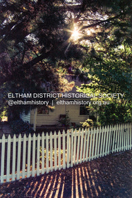 Eltham District Historical Society Inc
Photograph (Item) - Print, Andrew Peel, Untitled (Former Bootmaker's Shop), 1988
701 Main Road, Eltham Situated originally on the corner of the Dalton Street road reserve west of Main Road (now present-day Wingrove Park Trail), the former Jarrold Cottage (White Cloud) was purchased by Lena Skipper following Thekla Jarrold's death in 1943. It was built by William Jarrold in the early 1850s and was here that he married Hannah Coleman in 1856. The Bootmaker's shop was built by Thekla Jarrold in 1930 for use by her friend, John Clark, a local photographer who had boarded with the Jarrold family since about 1910. In 1930 he changed profession to a bootmaker and leather worker. The shop is one of only three remaining early 20th century shops in what was Little Eltham, the others being present-day San Antionio Barber Shop at 820 Main Road and Cafe Zen Den at 736 Main Road. Andrew Peel 1988 Entrant No. 28 Ref: Series 34, Items 11, 60-63 SHIRE OF ELTHAM COMMUNITY PHOTOGRAPHIC SURVEY Photography is an artform which many of us practice, sometimes purely for artistic pursuit, sometimes to record the people and events in our lives. In 1988, as part of a local Bicentennial project, the Shire of Eltham conducted the Eltham Community Photographic Survey. Up to 100 entries were to be selected by a panel of photographers for entry into the Eltham Photographic Survey Exhibition. Entries had to be submitted by May 13, 1988. Entrants whose images were selected for the exhibition were contacted and requested to further submit an entry form providing entrant’s name, area of residence, age, and proposed captions. These details were then used to produce labels for the exhibition mounts. Where negatives had not been supplied, these were requested to support the display of printed enlargements mounted on 10” x 8” cardboard. The mounted prints were made available post exhibition for sale at $8.50 each for colour prints and $7.00 for B&W prints. Residents in the Shire were invited to collect a free roll of film and take a photograph of what they either liked or did not like about the area. A total of 160 entrants submitted multiple entries for the exhibition. Of those selected for exhibition, entrants ranged in age from 9 to 70 years. All custom colour and black and white printing for the exhibition was completed by Wattle Studios of Eltham. The Eltham Photographic Survey was jointly auspiced by the Shire of Eltham and Wattle Studios, of 953 Main Road, Eltham. The project was greatly assisted by: • David McRitchie, Media Studies Lecturer Victoria College, Rusden Campus. • Ian and Annette Toohill of Wattle Studios • Tracy Naughton, Eltham Community Arts Officer • Neville Emerson Pty. Ltd. • Superior Press, Eltham • Kodak Australasia Pty. Ltd. • Agfa Gevaert Ltd. • Townsend Colourtech Pty. Ltd. • The Australian Bicentennial Authority • Eleanor Bowers, Secretary, Eltham Arts Council The exhibition was placed on display in the Woolworths Arcade, Eltham between Monday June 6th and Saturday June 11, 1988. It was also intended to hold the exhibition at a venue in the Shire’s North Riding from Monday, June 20 to Friday June 24. It was then displayed at the Were Street Theatre, Montmorency from Friday, June 24 to Thursday, July 7. Series 34: Eltham Community Photographic Survey 1988 - Prints & Documentation Series consists of 117 photographs of Shire scenes taken by members of the community. Items I - 41 are larger photographs mounted on card, which were exhibited. Items 42 - 117 are unmounted copies, alternative takes and other entries. Corresponding negatives contained in Series 35: Eltham Community Photographic Survey 1988 – Negatives which consists of 267 colour and B&W negatives and one colour slide of Shire scenes taken by members of the community. The negatives are arranged by the entrant number of the photographer. The Eltham Community Photographic Survey collection is significant to the local community as it was curated by the local community - ordinary people of all ages - representing what they liked and did not like in the area where they lived. It represents an unfiltered representation of the Shire of Eltham as it was in 1988. It also represents one of many projects as part of the national programme of events and celebrations to commemorate the bicentenary. It is a time capsule of life in the 1980s of this urban and rural municipality in Melbourne's north. Rear: Entrant No., name and address in blue ink; also 'Series 34' and the 'Item No.' in orange inkshire of eltham archives, bicentennial project, eltham, eltham community photographic survey, series 34, series 35, andrew peel, bootmaker's shop, film - kodak gb 200 5096, main road, scan - 35mm negative -
 Eltham District Historical Society Inc
Document - News Clipping, Natalie Town, Taskforce preserves links with the past, Diamond Valley News, September 11, p8, 1996
About former Shire / City council memorabilia. On the reverse side an article "Timing was the problem: chief" regarding Nillumbik CEO Barry Rochford dismissing claims that coulcil failed to follow correct statutory procedure when announcing the release of development plans for thje former Eltham Shire Office site in which developer Dallas Howgate intended to build a service station, convenience store, fast food outlet and community facilities including an information desk and meeting area.895 main road, barry rochford, bev marshall, dallas howgate, eltham shire office, nillumbik shire council, banyule city council, city of heidelberg, david hay, heidelberg historical society, honour board, joint memorabilia taskforce, mayoral chain, peter williams, roma o'callaghan, shire of diamond valley, shire of eltham -
 Eltham District Historical Society Inc
Photograph - Digital Photograph, Alan King, Jarrold Cottage, 701 Main Road, Eltham, 29 January 2008
Jarrold Cottage or White Cloud is known by many to be associated with the Skipper family, and has been since 1944 when Lena Skipper, wife of Mervyn Skipper purchased the cottage. She purchased it from the Estate of Thekla Jarrold who had died in March of the previous year. By the time Thekla died, she had lived in the Jarrold Cottage for 50 years. Thekla Alvenia Sissilia Ellian married John William Jarrold in 1888 at Clifton Hill. They started their family there but when John’s father William (who was married to Hannah Coleman) died in 1893 the family moved to Eltham. William had married Hannah Coleman in 1856 at his home in Eltham. William had arrived in the colony in 1848 so it is believed the Jarrold Cottage goes back at least to 1856 and possibly early 1850s. For a short period of time the cottage was rented to the Police as a temporary Police Station whilst a new and more permanent station was built further up the hill in 1859. The cottage was originally located closer to the Diamond Creek but was subject to flooding so was relocated to its present position on top a mound of rubble placed there from the nearby quarry next to the Dalton Street school (on Main Road). By 1916, John Henry Clark, a photographer who took many early photos of Eltham relocated from Fitzroy to Eltham and boarded with recently widowed Thekla Jarrold and her family. He changed professions from photographer to boot and harness maker around 1931 and Thekla had a small bootmakers shop built ifor him in the corner of her property next to the family home. J.H. Clark remained living at the property until his death in December 1956. At some stage after Clark's death, Lena Skipper is recorded living at the property having relocated from Montsalvat following the death of her husband Mervyn. The property continues to remain within the Skipper family as of 2023. Covered under Heritage Overlay, Nillumbik Planning Scheme. Published: Nillumbik Now and Then / Marguerite Marshall 2008; photographs Alan King with Marguerite Marshall.; p47This collection of almost 130 photos about places and people within the Shire of Nillumbik, an urban and rural municipality in Melbourne's north, contributes to an understanding of the history of the Shire. Published in 2008 immediately prior to the Black Saturday bushfires of February 7, 2009, it documents sites that were impacted, and in some cases destroyed by the fires. It includes photographs taken especially for the publication, creating a unique time capsule representing the Shire in the early 21st century. It remains the most recent comprehenesive publication devoted to the Shire's history connecting local residents to the past. nillumbik now and then (marshall-king) collection, bootmaker's shop, hannah coleman, jarrold cottage, john henry clark, john william jarrold, lena skipper, police station, thekla alvenia sissilia jarrold (nee ellian), white cloud cottage, william jarrold -
 Eltham District Historical Society Inc
Photograph - Digital Photograph, Alan King, Former bootmaker's shop, Main Road Eltham, 29 January 2008
The former bootmaker's shop is one of only three remaining original shops from the early 20th century in what was once Little Eltham, the others being the present day Cafe Zen-Den at 736 Main Road and the former Burgoyne General Store and Post Office, present-day San Antonio Barbershop at 820 Main Road. Jarrold Cottage or White Cloud is known by many to be associated with the Skipper family, and has been since 1944 when Lena Skipper, wife of Mervyn Skipper purchased the cottage. She purchased it from the Estate of Thekla Jarrold who had died in March of the previous year. By the time Thekla died, she had lived in the Jarrold Cottage for 50 years. Thekla Alvenia Sissilia Ellian married John William Jarrold in 1888 at Clifton Hill. They started their family there but when John’s father William (who was married to Hannah Coleman) died in 1893 the family moved to Eltham. William had married Hannah Coleman in 1856 at his home in Eltham. William had arrived in the colony in 1848 so it is believed the Jarrold Cottage goes back at least to 1856 and possibly early 1850s. For a short period of time the cottage was rented to the Police as a temporary Police Station whilst a new and more permanent station was built further up the hill in 1859. The cottage was originally located closer to the Diamond Creek but was subject to flooding so was relocated to its present position on top a mound of rubble placed there from the nearby quarry next to the Dalton Street school (on Main Road). By 1916, John Henry Clark, a photographer who took many early photos of Eltham relocated from Fitzroy to Eltham and boarded with recently widowed Thekla Jarrold and her family. He changed professions from photographer to boot and harness maker around 1931 and Thekla had a small bootmakers shop built ifor him in the corner of her property next to the family home. J.H. Clark remained living at the property until his death in December 1956. At some stage after Clark's death, Lena Skipper is recorded living at the property having relocated from Montsalvat following the death of her husband Mervyn. The property continues to remain within the Skipper family as of 2023. Covered under Heritage Overlay, Nillumbik Planning Scheme. Published: Nillumbik Now and Then / Marguerite Marshall 2008; photographs Alan King with Marguerite Marshall.; p47This collection of almost 130 photos about places and people within the Shire of Nillumbik, an urban and rural municipality in Melbourne's north, contributes to an understanding of the history of the Shire. Published in 2008 immediately prior to the Black Saturday bushfires of February 7, 2009, it documents sites that were impacted, and in some cases destroyed by the fires. It includes photographs taken especially for the publication, creating a unique time capsule representing the Shire in the early 21st century. It remains the most recent comprehenesive publication devoted to the Shire's history connecting local residents to the past. nillumbik now and then (marshall-king) collection, bootmaker's shop, jarrold cottage, john henry clark, lena skipper, thekla alvenia sissilia jarrold (nee ellian), white cloud cottage, shops -
 Eltham District Historical Society Inc
Photograph, Peter Pidgeon, Grave of John and Mary Murray, Eltham Cemetery, Victoria, 5 April 2021
Irish-born John Murray and his wife Mary (daughter of Thomas Sweeney) married in 1849 and settled in Eltham North. John and Mary were amongst the earliest inhabitants of Eltham. John was a farmer and their block of about 80 acres, called ‘Laurel Hill’, was on the eastern side of the Diamond Creek, extending east to beyond Zig Zag Road. It was later extended southward by the purchase of a further 60 acres. He is recorded as a supporter on the petition for a school in Eltham and he served on the National School Board of the Eltham school. John died in 1867 and is buried in Eltham Cemetery with Mary and with two of their grandchildren. Their eldest son Johnnie inherited the property. Then in about 1902 his younger brother James purchased about 50 acres on the western side of the Diamond Creek immediately opposite Laurel Hill, extending west to slightly past Wattletree Road. Eltham North Reserve now lies just beyond the southern boundary. James built a family home on top of the hill on the northern boundary, together with a dairy and milking shed and a food cellar. It is thought that the barn with stables was already there. When Johnnie died in 1912, the two properties (though severed by both the creek and the railway line) effectively merged. The land was worked as an orchard with apples, pears, quinces, and possibly apricots and peaches. Later it became a dairy farm. By 1986, almost all the land had been sold off for residential subdivision and the house had been condemned as unfit for habitation. John's grandson Jim retained a small portion of the land and built a new house. He kept the old one as a storage shed, but it was demolished after he died in 1993. The very old barn is still standing. Located in the Roman Catholic section In Memory of John Murray Who died Dec. 1867 aged 50 years Also his wife Mary Murray Who died 7th Sep. 1909 aged 76 years And of their grandchildren Thomas and Mary Ellen DrainBorn Digitaleltham cemetery, gravestones, john murray, mary ellen drain, mary murray, thomas drain -
 Eltham District Historical Society Inc
Photograph - Colour Print, Harry Gilham, Eltham Roll of Honour, Eltham War Memorial Hall, Nov 2004
The Eltham Roll of Honour Board was originally commissioned and paid for by the Eltham War Memorial Trust from funds raised by public donation. It was originally hung in the Infant Welfare Centre. In 1999 the Honour Roll Board was removed from the Eltham War Memorial by members of the RSL and relocated to the Eltham RSL sub-branch on Main Road. Following financial collapse of the Eltham RSL sub-branch and merger of the Eltham and Montmorency sub-branches and subsequent sale of the Eltham property, the WW1 obelisk was relocated to a location in front of the Eltham War Memorial. The Honour Roll Board was retrieved by former Eltham District Historical Society President, Harry Gilham in September 2004 who arranged for it to be re-hung in the Eltham War Memorial Hall (former Children's Library) where it was attached to the brick wall face of the west (rear) wall of the Hall (as seen in this photograph). Sometime around late 2018 when Council was investigating the potential sale and development of the Eltham War Memorial, the Eltham Honour Roll Board was once again removed from the Eltham War Memorial by persons unknown, under the pretext of ‘safekeeping,’ to a location outside of the Shire of Nillumbik, in the City of Banyule. In early 2021 Eltham District Historical Society was made aware of the removal of the Honour Roll Board. A formal request was made by EDHS to return this community asset to its rightful place as intended when it was commissioned and paid for by the Eltham War Memorial Trust. This request was rebutted. Nillumbik Shire Council has also since been made aware of the removal of this community asset and formally requested its return prior to Anzac Day, 2021 where it can once again be made accessible to members of the community to pay their respects as originally intended. As of July 2022, the Honour Board remains missing from its rightful place at the Eltham War Memorial. eltham war memorial hall, honour board, honour roll, roll of honour -
 Eltham District Historical Society Inc
Photograph, Peter Pidgeon, Former Bootmaker's shop and White Cloud Cottage, 701 Main Road, Eltham, 2 Aug. 2022
Situated originally on the corner of the Dalton Street road reserve west of Main Road (now present-day Wingrove Park Trail), the former Jarrold Cottage (White Cloud) was purchased by Lena Skipper following Thekla Jarrold's death in 1943. It was built by William Jarrold in the early 1850s and was here that he married Hannah Coleman in 1856. The Bootmaker's shop was built by Thekla Jarrold in 1930 for use by her friend, John Clark, a local photographer who had boarded with the Jarrold family since about 1910. In 1930 he changed profession to a bootmaker and leather worker. The shop is one of only three remaining early 20th century shops in what was Little Eltham, the others being present-day San Antionio Barber Shop at 820 Main Road and Cafe Zen Den at 736 Main Road. Part of a presentation by Peter Pidgeon to the Society, 13 August 2022 showcasing a series of photographs taken by John Henry Clark over the period 1895 to 1930.Born Digitaleltham, main road, bootmaker's shop, jarrold cottage, white cloud cottage, shops, wingrove park trail -
 Eltham District Historical Society Inc
Photograph, Peter Pidgeon, Former Bootmaker's shop, 701 Main Road, Eltham, 2 Aug. 2022
Situated originally on the corner of the Dalton Street road reserve west of Main Road (now present-day Wingrove Park Trail), the former Jarrold Cottage (White Cloud) was purchased by Lena Skipper following Thekla Jarrold's death in 1943. It was built by William Jarrold in the early 1850s and was here that he married Hannah Coleman in 1856. The Bootmaker's shop was built by Thekla Jarrold in 1930 for use by her friend, John Clark, a local photographer who had boarded with the Jarrold family since about 1910. In 1930 he changed profession to a bootmaker and leather worker. The shop is one of only three remaining early 20th century shops in what was Little Eltham, the others being present-day San Antionio Barber Shop at 820 Main Road and Cafe Zen Den at 736 Main Road. Part of a presentation by Peter Pidgeon to the Society, 13 August 2022 showcasing a series of photographs taken by John Henry Clark over the period 1895 to 1930.Born Digitaleltham, main road, bootmaker's shop, jarrold cottage, white cloud cottage, shops, wingrove park trail -
 Eltham District Historical Society Inc
Photograph, Peter Pidgeon, White Cloud Cottage, 701 Main Road, Eltham, 2 Aug. 2022
Situated originally on the corner of the Dalton Street road reserve west of Main Road (now present-day Wingrove Park Trail), the former Jarrold Cottage (White Cloud) was purchased by Lena Skipper following Thekla Jarrold's death in 1943. It was built by William Jarrold in the early 1850s and was here that he married Hannah Coleman in 1856. The Bootmaker's shop was built by Thekla Jarrold in 1930 for use by her friend, John Clark, a local photographer who had boarded with the Jarrold family since about 1910. In 1930 he changed profession to a bootmaker and leather worker. The shop is one of only three remaining early 20th century shops in what was Little Eltham, the others being present-day San Antionio Barber Shop at 820 Main Road and Cafe Zen Den at 736 Main Road.Born Digitaleltham, main road, bootmaker's shop, jarrold cottage, white cloud cottage, shops, wingrove park trail