Showing 645 items matching "environment victoria"
-
 University of Melbourne, Burnley Campus Archives
Legal record, Environment and Natural Resources Committee et al, Inquiry Into Pest Plants in Victoria, 1996
... Boulevard Richmond melbourne pest plants victoria environment ...pest plants, victoria, environment and natural resources committee, dr gregory moore, dors berry, kate mccormick, noxious weeds, pesticides -
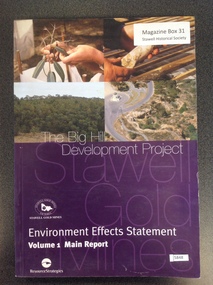 Stawell Historical Society Inc
Book, Resource Strategies Pty Ltd, The Big Hill Development Project - Environmental Effects Statement - Main Report, 1999
... Victoria Environment Effects Statement Volume 1 Main Report... Mines Victoria Environment Effects Statement Volume 1 Main ...Enviromental Effects statement for the Stawell Gold Mine.Purple card cover with four colour photos in top halfThe Big Hil Development Project. Stawell Gold Mines Victoria Environment Effects Statement Volume 1 Main Report Resources Strategiesstawell gold mining -
Lakes Entrance Historical Society
Book, East Gippsland Shire Council, East Gippsland Shire Proposed Environmental Strategy 2008, 2008
... having an environment profile East Gippsland Victoria...Environment Waste Disposal Water supply A report ...A report of the proposed environmental strategy resulting from an extensive consultation process with various agencies having an environment profile East Gippsland Victoriaenvironment, waste disposal, water supply -
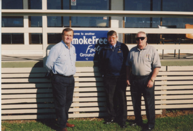 Lakes Entrance Historical Society
Photograph - Football, Lakes Post Newspaper, 1/03/1999 12:00:00 AM
... Officials in promoting smoke free environment in every environment... in promoting smoke free environment in every environment Lakes Entrance ...Other number 03639.2Colour photograph of Ray Barling East Gippsland Football League Vice President accepting Boose Less Award on Behalf of East Gippsland Football League with Kevin Mathews and Don Brady Officials in promoting smoke free environment in every environment Lakes Entrance Victoriaclubs, football, awards -
Glenelg Shire Council Cultural Collection
Poster - Poster - Portland Upwelling Festival, Oct-09
... coastal environment in Portland Victoria.... to celebrate what is unique about our beautiful coastal environment ...The Bonney Upwelling is the epic natural ocean occurrence that powers a 7 month ( November – May ) feeding frenzy of marine animals, supporting an incredibly rich ecological food web. The Upwelling is at its greatest off the coast of Portland and is the corner stone of our lucrative fishing and tourism industries. Presented by the Upwelling Festival Committee Inc. The Upwelling Festival is a free one day event that brings the community and visitors together to celebrate what is unique about our beautiful coastal environment in Portland Victoria.Two A3 sized posters promoting Portland's Upwelling Festival, Saturday October 31 2009. Shiny White paper. Printed over with pale grey. Blue outline of whale in blue sea; Dark/light blue and green ribbons of colour lead to lighthouse. Features of Festival printed in dark/light blue,green,grey. sponsors names and logos along bottom edge.upwelling, community, festival program, marine -
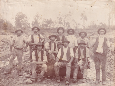 The Beechworth Burke Museum
Photograph, c. 1870
This photograph was captured at an undisclosed location and at an unidentified time but likely dates to approximately 1870. The photographer's details are not recorded and the identities of the men in the image are also not known. This image depicts a group of 10 men in typical miners fashion. Four of them are sat on a large log with one holding a small dog. Six miners stand behind those sitting. All these men are wearing a white button-up shirt and tan coloured work trousers. They wear heavy boots and seven have included a dark vest over their shirt. The man holding the dog has a pipe in his mouth. Two of these men are clean shaven with the remainder sporting a moustache and two with a beard. The ages of these men vary from late 20s to middle age. This group of men are located in a mining location with what appears to be an open cut mine in the background of the image. The ground is muddy and has elements which can help identify it as a mining location based on the condition of the landscape. The bottom of the men's trousers are muddy which provides the assurance that these men were working in this location when their photograph was captured. In the background there is one structure, possibly a dwelling, and bush which identifies the location as Australia. Open cut sluicing is a method used to extract gold and other precious metals from beneath the surface of the earth. This technique involved the use of high-powered hoses which broke down the soil enabling miners to come along and search this soil for gold. After the gold rush of the early 1850s, diggers had to enlist the assistance of heavy machinery and techniques like hydraulic sluicing in order to reach gold because the surface alluvial gold had already been discovered and removed. This heavy machinery was not used until after 1853. The search for gold is ingrained into the history of Victoria and therefore, images like this one which portray an open cut sluicing site can reveal important information for society and technology for the date when the photograph was taken. This image is of important historical significance for its ability to convey information about sluicing and the methods used to find gold in the late 1800s and early 1900s. It also shows a location where sluicing was undertook which provides insight into the impact of sluicing on the environment at a time when it was done. Images, like this one, of Australian gold rush history can reveal important information about the social and environmental impact of this period. This image depicts diggers standing in a mining location and therefore, this image has the capacity to reveal or support significant information for researchers studying the fashion and social status of diggers in Australia in approximately 1870. It can also provide information on the landscape of Australia in this period and the impact of mining for gold on both society and the Australian landscape. The Burke Museum is home to a substantial collection of Australian mining photographs which can be used to gain a deeper understanding into life on the gold fields, technology used in mining, the miners themselves and the impact of the gold digging on the environment.Sepia toned rectangular photograph printed on matte photographic paper mounted on board.Reverse: 1997.2518mining, goldfields, beechworth, 1870, australia, australian goldfields, diggers, victoria, sluicing, gold mining, miners, diggers victoria -
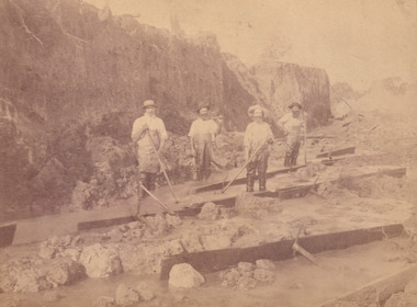 The Beechworth Burke Museum
Photograph, c.1870
This photograph was taken in approximately 1870 and depicts four male miners standing in mining sluice at the Three Mile Goldfields. These men are wearing typical attire for 1870s gold miners. They wear white shirts, tan coloured pants with water proof shoes and most of the men are wearing an apron to prevent their clothing from becoming too dirty from the mud. Each man is wearing a wide brim hat and hold large wooden tools used for sorting through the sluice. Three of the four men have full beards. The photograph was donated to the Burke Museum by R. Ziegenbein before 2001 but the photographer and the individuals captured in the photo are unknown. The image depicts the landscape of the Three Mile Goldfields during a period when open cut sluicing was undertaken to reach gold. Open cut sluicing is a method used to extract gold and other precious metals from beneath the surface of the earth. This technique involved the use of high-powered hoses which broke down the soil enabling miners to come along and search this soil for gold. After the gold rush of the early 1850s, diggers had to enlist the assistance of heavy machinery and techniques like hydraulic sluicing in order to reach gold because the surface alluvial gold had already been discovered and removed. This heavy machinery was not used until after 1853. The Three Mile Goldfields was a site of rich alluvial gold deposits located about 5 km south of Beechworth in Victoria. Today, the location of this gold deposit is called Baarmutha. It was a popular area for gold mining in the 1850s but became largely abandoned by the following decade. In 1865, a man named John Pund recognized that the area could be potentially rich if a better water supply could be obtained. He secured a 15 year license with three other miners. Within the next five years, these men had constructed 19 km of water race going from Upper Nine Mile Creek to Three Mile Creek. By 1881, these four men had delivered 950,000 gallons to the Three Mile Sluicing area which is depicted in this photograph. Pund was later go into partnership with John Alston Wallace who would become owner of the Star Hotel in Beechworth. The Three Mile sluicing location continued to be operational until 1950. Sluice box workers were a vital part of gold mining regardless of how inefficient they were in the recovery of gold. After using hydraulic sluicing to cut away the earth, miners would use the big wooden boxes depicted in the image to catch the earth which would then be sifted for gold. However, accidents would occur often which would result in the gold washing away and unable to be recovered. It was not a very efficient system because the gold, which was alluvial and thus very fine, would often pass through the sluice box undetected.The search for gold is ingrained into the history of Victoria and therefore, images like this one which portray an open cut sluicing site can reveal important information for society and technology for the date when the photograph was taken. This image is of important historical significance for its ability to convey information about sluicing and the methods used to find gold in the late 1800s and early 1900s. It also shows a location where sluicing was undertook which provides insight into the impact of sluicing on the environment at a time when it was done. Images, like this one, of Australian gold rush history can reveal important information about the social and environmental impact of this period. This image depicts diggers standing in a mining location and therefore, this image has the capacity to reveal or support significant information for researchers studying the fashion and social status of diggers in Australia in approximately 1870. It can also provide information on the landscape of Australia in this period and the impact of mining for gold on both society and the Australian landscape. The Burke Museum is home to a substantial collection of Australian mining photographs which can be used to gain a deeper understanding into life on the gold fields, technology used in mining, the miners themselves and the impact of the gold digging on the environment.Sepia toned rectangular photograph printed on matte photographic paper and mounted on board.[illegible] about 1870 / 97 2514.1 / 2594 30three mile goldfields, goldfields, 1870, 1870 gold, australia, australian landscape, miners, gold miners, diggers, gold diggers, beechworth, victoria, sluice box workers, sluicing, sluice, mining -
 The Beechworth Burke Museum
Photograph - Photograph - Reproduction, W. D. Gibbon, Early 1900s
This photograph was taken in 1911 at Three Mile Creek, about five kilometers south of Beechworth town. Significant digging took place at this location from late 1855, which led to a flood of workers and stores to follow, though daily earnings were slim compared to the nearby Woolshed site. This remained the case even after workers at Three Mile Creek attempted to protest around Beechworth during an election in November 1855. Three Mile Creek was one of seven significant divisions of the Beechworth Mining District formalised by the Governor-in-Council in 1858, though by the time this photograph was taken, the boundaries of the original seven districts had shifted to create seventeen divisions. The Three Mile Goldfields was a site of rich alluvial gold deposits located about 5km south of Beechworth in Victoria. Today, the location of this gold deposit is called Baarmutha. It was a popular area for gold mining in the 1850s but became largely abandoned by the following decade. In 1865, a man named John Pund (a man second from the left in the back row of this photograph shares this surname) recognized that the area could be potentially rich if a better water supply could be obtained. He secured a 15 year license with three other miners. Within the next five years, these men had constructed 19 km of water race going from Upper Nine Mile Creek to Three Mile Creek. By 1881, these four men had delivered 950,000 gallons to the Three Mile Sluicing area which is depicted in this photograph. Pund would later go into partnership with John Alston Wallace who would become owner of the Star Hotel in Beechworth. The Three Mile sluicing location continued to be operational until 1950. The eleven miners in this photograph are: Back row: Led Guthrie, P. Pund, F. Beel, [Unknown] Miller Front row: Paddy McNamara, J. King, W. Beel, [Unknown] Garland, J. Clarke, J. Ryan, H. Bartsh In the background of the photograph is a huge dirt wall that appears to suffer damage caused by hydraulic sluicing. Hydraulic sluicing is a specialised mining technique that involves directing high pressure water flows at dirt to uncover gold. The technique played a significant role in shaping Beechworth's landscape during the gold rush to create the topography seen today.The search for gold is ingrained into the history of Victoria and therefore, images like this one which portray an open cut sluicing site can reveal important information for society and technology for the date when the photograph was taken. This image is of important historical significance for its ability to convey information about sluicing and the methods used to find gold in the late 1800s and early 1900s. It also shows a location where sluicing was undertook which provides insight into the impact of sluicing on the environment at a time when it was done. Images, like this one, of Australian gold rush history can reveal important information about the social and environmental impact of this period. This image depicts diggers standing in a mining location and therefore, this image has the capacity to reveal or support significant information for researchers studying the fashion and social status of diggers in Australia in approximately 1911. It can also provide information on the landscape of Australia in this period and the impact of mining for gold on both society and the Australian landscape. The Burke Museum is home to a substantial collection of Australian mining photographs which can be used to gain a deeper understanding into life on the gold fields, technology used in mining, the miners themselves and the impact of the gold digging on the environment.Black and white / sepia rectangular reproduced photograph printed on glossy photographic paper mounted on board.beechworth, beechworth museum, mining, mining team, three mile creek, sluicing, hydraulic sluicing, photography, gold sluicing, gold mining, pund mining -
 The Beechworth Burke Museum
Photograph - Photograph - Reproduction, 1890-1900
The photograph appears to depict the of the entrance to the Rocky Mountain Tunnel. The Rocky Mountain Tunnel runs from opening of the tunnel, underneath the Beechworth town, to the Gorge. This tunnel drained the excess water from the upper Spring Creek Goldfield to allow for mining access in the area. The Rocky Mountain Co. blasted through the granite rock to create the original 400ft-long tunnel in 1859, but between 1867 and 1871, the Rocky Mountain Gold Sluicing Co. widened and extended it. At its completion, it measured 14ft deep, 6ft wide, and almost half a mile long. The mining surveyor at Beechworth called it 'without doubt, the greatest undertaking of the kind in the colony'. When the company became the Rocky Mountain Extended Gold Sluicing Co. in the mid-1870s, they continued the tunnelling work. The work was reportedly vital to mining being able to continue at Beechworth and may have established world records in tunnelling through hard rock. The entrance at the Gorge side of the tunnel can be seen from the Beechworth Gorge Walk. The tunnel continues to be an outfall drain for the lake and the town.The search for gold is ingrained into the history of Victoria and therefore, images like this one which portray an open cut sluicing site can reveal important information for society and technology for the date when the photograph was taken. This image is of important historical significance for its ability to convey information about sluicing and the methods used to find gold in the late 1800s and early 1900s. It also shows a location where sluicing was undertook which provides insight into the impact of sluicing on the environment at a time when it was done. The Burke Museum is home to a substantial collection of Australian mining photographs which can be used to gain a deeper understanding into life on the gold fields, technology used in mining, the miners themselves and the impact of the gold digging on the environment.A black and white rectangular reproduced photograph printed on matte photographic paper.7814beechworth, beechworth museum, burke museum, australian museum, mining, rocky mountain mining co., rocky mountain mining company, mine, mining company, rocky mountain mine, mine entrance, rocky mountain, gold, gold mining -
 The Beechworth Burke Museum
Photograph, est. 1860-1875
In 1875, the Rocky Mountain Extended Gold Sluicing Company Ltd was created, utilising the previous Rocky Mountain claim for the area near Lake Sambell. The company employed A.L Martin to survey an area for a tunnel underneath Beechworth and Johnson Stephens to dig it. The tunnel was built at a rate of 40 feet a month and eventually measured 800 metres. The tunnel was a true accomplishment both in the present and during the 19th century. It was considered to be a marvelous engineering feat. Beechworth is renowned for its hydraulic sluice method of mining. This involved soil being exposed to torrents of water from high-pressure hoses. From 1876 until its closure in 1921, the mine produced an astounding 47,926 ozs of gold. Companies like this were the source of income for many Chinese gold-diggers who sought to make their fortune on the goldfields of Beechworth. During the height of the rush, the town had around 7,000 Chinese inhabitants living on the outskirts of town as they were not permitted to live within Beechworth itself.The search for gold is ingrained into the history of Victoria and therefore, images like this one which portrays an open-cut sluicing site can reveal important information for society and technology for the date when the photograph was taken. This image is of important historical significance for its ability to convey information about sluicing and the methods used to find gold in 1910. It also shows a location where sluicing was undertaken which provides insight into the impact of sluicing on the environment at a time when it was done. This image of the Rocky Mountain mine is historically significant as the mining complex is now non-existent, with the only remains being the tunnel built in 1880 by the company, which was considered one of the greatest engineering feats of the time. The image also provides a first-hand look into the social and cultural networks at play during the 19th century with racial segregation of the Chinese at the 'Chinese Camp', as well as an insight into Beechworth's origins during the Gold Rush.A sepia rectangular photograph printed on matte photographic paper as a postcardReverse: Historic Beechworth / 7792.1 / ROCKY MOUNTAIN MINE / Viewed from the “Chinese Camp”, shown partly in the foreground, we see the central plant of the famous Rocky Mountain Mining Company. This extensive complex, of which nothing remains, was situated between Silver Creek and the present Lake Sambell area. The company was responsible for a tunnel cut through solid bedrock underneath the town of Beechworth and surfacing near the keystone bridge on the Wangaratta side. Completed in 1880 it was declared to be one of the greatest engineering feats in Australia. The tunnel is still basically intact today. / Series by Wooragee Graphics: Historic Beechworth. / COPYRIGHT BURKE MUSEUM / No.72 beechworth, rocky mountain mine, sluicing, gold rush, mining, gold -
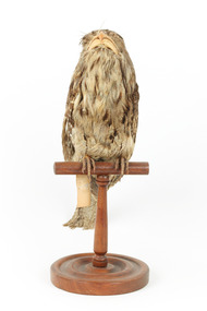 The Beechworth Burke Museum
Animal specimen - Tawny Frogmouth, Trustees of the Australian Museum, 1860-1880
The Tawny Frogmouth, although often mistaken for an owl, is a nocturnal Australian bird of the Podargidae family that is more closely related to the nightjars. They are widespread in terms of distribution and can be found all across mainland Australia and Tasmania in a diverse variety of habitats from woodlands, forests and urban areas. Masters of camouflage, the Tawny Frogmouth sleeps during the day on tree branches in a stiff upward facing position (as with this specimen) to mimic broken tree branches, their feathers assist in this deception as the mottled grey and brown colours blend into the environment seamlessly. This specimen differs in colours from the usual appearance of a Tawny Frogmouth, as the beak is usually a olive-grey to blackish tone and the plumage is generally more dominantly grey all over the bird. This specimen is part of a collection of almost 200 animal specimens that were originally acquired as skins from various institutions across Australia, including the Australian Museum in Sydney and the National Museum of Victoria (known as Museums Victoria since 1983), as well as individuals such as amateur anthropologist Reynell Eveleigh Johns between 1860-1880. These skins were then mounted by members of the Burke Museum Committee and put-on display in the formal space of the Museum’s original exhibition hall where they continue to be on display. This display of taxidermy mounts initially served to instruct visitors to the Burke Museum of the natural world around them, today it serves as an insight into the collecting habits of the 19th century.This specimen is part of a significant and rare taxidermy mount collection in the Burke Museum. This collection is scientifically and culturally important for reminding us of how science continues to shape our understanding of the modern world. They demonstrate a capacity to hold evidence of how Australia’s fauna history existed in the past and are potentially important for future environmental research. This collection continues to be on display in the Museum and has become a key part to interpreting the collecting habits of the 19th century.This Tawny Frogmouth has a broad head and a creamy beige coloured wide triangular beak with a hooked tip. The plumage on the head and back of the bird is a combination of darker and rufous browns, mottled with streaks of cream and grey. The underside of the bird from the bottom of the beak to the tail tip is a lighter cream colour with streaks of rufous-brown. The feet are an orange-brown colour. This specimen is adopting the skyward looking pose associated with the species, mimicking dead tree branches.1a. / More-Park / See Catalogue, page 7 /taxidermy mount, taxidermy, burke museum, beechworth, australian museum, skin, reynell eveleigh johns, bird, australian birds, tawny frogmouth, frogmouth -
 The Beechworth Burke Museum
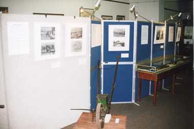
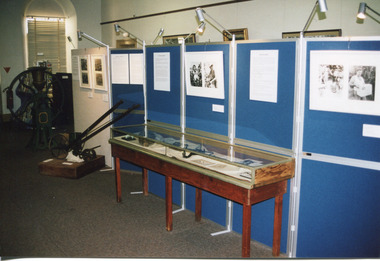
Photograph, 1999
Taken in 1999, the photograph depicts a section of “The Harvest” exhibition held at the Burke Museum between May 1st and June 20th 1999 as part of the Baking Industry Victoria. In the foreground is believed to be an old seed distributor. The grain mill made by B. M. Purshouse in Wolverhampton, United Kingdom, was of special interest during the exhibition. This photograph is of historical and research significance, connecting with various themes such as farming, adapting to diverse environments, and the promotion of settlement in Victoria. The photograph is an example of an exhibition held at the Burke Museum in 1999, demonstrating the communal interest of Beechworth in their farming history. The photograph contains a strong interpretive capacity as it demonstrates the importance of farming to Beechworth and Beechworth's history, revealing the enduring connection between the local community and the surrounding land. The historical and research value of the photograph is further enhanced by the depiction of historical farming machinery, providing a means for future generations to view historical machines used in farming. Colour rectangular photograph printed on photographic paper.Reverse: 2857burke museum, the harvest, exhibition, baking industry, grain mill, b. m. purshouse, beechworth, baking industry victoria, seed, seed distributor -
 The Beechworth Burke Museum
Photograph, 1999
Taken in 1999, the photograph depicts a section of “The Harvest” exhibition held at the Burke Museum between May 1st and June 20th 1999 as part of the Baking Industry Victoria. In the foreground is depicted a seed distributor. The grain mill, which can be seen in the background, was made by B. M. Purshouse in Wolverhampton, United Kingdom, and was of special interest during the exhibition. This photograph is of historical and research significance, connecting with various themes such as farming, adapting to diverse environments, and the promotion of settlement in Victoria. The photograph is an example of an exhibition held at the Burke Museum in 1999, demonstrating the communal interest of Beechworth in their farming history. The photograph contains a strong interpretive capacity as it demonstrates the importance of farming to Beechworth and Beechworth's history, revealing the enduring connection between the local community and the surrounding land. The historical and research value of the photograph is further enhanced by the depiction of historical farming machinery, providing a means for future generations to view historical machines used in farming.Colour rectangular photograph printed on photographic paper.Reverse: 2855burke museum, the harvest, baking industry, baking industry victoria, seed distributor, grain mill, b. m. purshouse, beechworth, exhibition -
 The Beechworth Burke Museum
Photograph, c1990
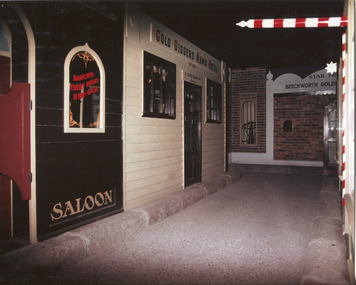
Taken in the 1990's, this photograph depicts a row of shop fronts in the 'Street of Shops' exhibition in the Burke Museum in Beechworth. This exhibition was created and opened in 1979 and was intended to reflect and imitate a historic peirod in the town's past. The time period decpicted is that of the Gold Rush which swept through many Victorian towns from the 1850's onwards. For the town of Beechworth, the gold rush began in 1852, when gold was discovered in Spring Creek, drawing in many new residents seeking to make a fortune and transforming a once remote town into a bustling centre brimming with hope and opportunity. By 1857, the town contained over 200,000 residents and with this, the need for more amenities and intsitutions arose. Multiple churches, banks, schools, shops, hospitals and other essential buildings appearing over the years. The wealth acquired through the gold rush is largely responsible for the vast development of the town and many of its significant buildings which still remain to this day. This photograph also highlights the significance of this type of exhibition, providing a new mode of experiencing and learning about the past. The street depicts the many supporting trades and industries that arose from the mass migration during the gold rush. The creation of the Street of Shops in 1979 was envisioned by Roy Harvey who was the curator at the time, with the intention of recreating an authentic feel to the environment while collecting from the community to accurately portray the multiculturalism that is ingrainded in many towns and communities of Victoria. This photograph contains historical significance as it relates to and portrays an especially important period of time within Beechworth and Victoria's history. The gold rush phenomena ushered in a wave of hope and prosperity for citizens and immigrants alike. It provided many with the opportunity to strike it rich, while the town prospered and grew in many ways. This widespread development that accompanied the gold rush occured throughout Victoria and holds great historical importance when recording the social, economic and communal developments that occured throughout the time period which gave way to the beloved towns and communities we know today. Beechworth itself is acknowledged as Victoria's best-preserved gold mining town and deserves recognition of its significance. it also showcases the great significance of social develpment and globalization that occured throughout the state during this period. Coloured rectangular photograph printed on matte photographic paper and unmounted. Obverse: Dancing every night 8pm-6am [mirror] / Gold Diggers Arms Hotel façade / Star / Beechworth Gold / J. Davidson / Saloon Reverse: 3306 beechworth, burke museum, street of shops, gold rush, indigo shire gold rush, 1850s beechworth, burke museum exhibitions, saloon, gold buyer, hotel, historical streetscape, gold rush immigration -
 The Beechworth Burke Museum
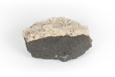
Geological specimen - Hyalite in Basalt
According to the 1912 Department of Mines Bulletin of the Geological Survey of Victoria, basalt covers a considerable portion of the Macedon area including Mount Macedon. Basalt is the most common form of rock underlying the earth's surface and is found in three kinds of rock forming environments: ocean divergent boundaries, oceanic hotspots, and mantle plumes and hotspots beneath continents.This specimen is part of a larger collection of geological and mineral specimens collected from around Australia (and some parts of the world) and donated to the Burke Museum between 1868-1880. A large percentage of these specimens were collected in Victoria as part of the Geological Survey of Victoria that begun in 1852 (in response to the Gold Rush) to study and map the geology of Victoria. Collecting geological specimens was an important part of mapping and understanding the scientific makeup of the earth. Many of these specimens were sent to research and collecting organisations across Australia, including the Burke Museum, to educate and encourage further study.A solid mass, geological specimen in shades of grey and white. Hyalite is a colourless variety of opal. It occurs as globular and botryoidal masses and irregular crusts in volcanic and pegmatite environments where the silica deposits from the gas phase. Basalt is dark in colour, fine-grained igneous rock composed of plagioclase and pyroxene minerals. It is commonly formed as an extrusive rock, such as lava flow. It is one of the most common forms of rock underlying the earth's surface.burke museum, geological specimen, department of mines, geological survey of victoria, basalt, mount macedon, beechworth -
 The Beechworth Burke Museum
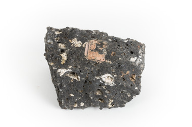
Geological specimen - Basalt, Unknown
Basalt is a common igneous rock that composes most of the Earth's surface and can be found on the Moon and other rocky planets of the Solar System. It is generally composed minerals such as calcic plagioclase, clinopyroxene and iron ore which form grains that are indistinguishable to the naked eye. It can be dark grey or black in colouring and sometimes may contain holes left by gas bubbles. Most of the Earth's basalt was produced in environments such as oceanic divergent boundaries, oceanic hotspots, and mantle plumes and hotspots beneath continents. Basalt is commonly used in construction where it is crushed and used for multiple purposes such as concrete aggregate, road base, or railroad ballast. Thin slabs of basalt can also be cut and used for floor tiles, stone monuments, and building veneer. This particular specimen was excavated from Talbot in Victoria, which was a small gold mining town established in 1852. As basalt is a common rock, it is not specific to Talbot. However, this specimen can be assumed to be of the Cainozoic age due to previous geomorphic surveys of the area. This particular type of Basalt was used mainly for roads due to the durability of the rock.Basalt holds significance due to the continued use of the rock from historic until present times. The rock has been utilised for many types of construction and is still used for the same purposes today. Basalt also has significance to the Earth and other rocky planets of the Solar System as it makes up most of the planet's surface. This specimen is part of a larger collection of geological and mineral specimens collected from around Australia (and some parts of the world) and donated to the Burke Museum between 1868-1880. A large percentage of these specimens were collected in Victoria as part of the Geological Survey of Victoria that begun in 1852 (in response to the Gold Rush) to study and map the geology of Victoria. Collecting geological specimens was an important part of mapping and understanding the scientific makeup of the earth. Many of these specimens were sent to research and collecting organisations across Australia, including the Burke Museum, to educate and encourage further study.A smaller than hand sized rock specimen which is dark grey in colour with small holes and white deposits across its surface.Geological survey / [illegible] /burke museum, beechworth, geological specimen, geology, basalt, basalt specemin, indigo shire, talbot, cainozoic, igneous rock -
 The Beechworth Burke Museum
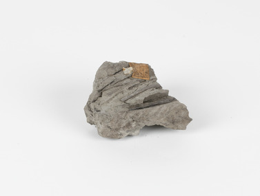
Geological specimen - Fossiliferous Mudstone, Unknown
This specimen was found in Cape Patterson, Vic. Cape Paterson is a cape and seaside village located near the town of Wonthaggi, 132 kilometres southeast of Melbourne, in the Bass Coast Shire of Gippsland, Victoria, Australia. These dark, fossiliferous Mudstones were deposited in slow-moving water associated with sedimentary basins & continental shelves. They are rich in carbon which makes them almost black. This is typical of an anoxic, reducing environment such as deep water or stagnant conditions where carbon-rich material would remain unoxidised during subsequent deposition & diagenesis. it has an imprint of a leaf in the rock itself, displaying the fossil of the plant. This specimen is unique due to the leaf impression within the stone itself. Imprint fossils are formed from an organism moving in some way, leaving behind a trace or track. These tracks are preserved when the clay/silt dries slowly and is covered by other sediment. Plants can also leave imprint fossils when they are covered by sediment. The leaf tissue degrades, leaving an imprint of where the leaf once was. This specimen is part of a larger collection of geological and mineral specimens collected from around Australia (and some parts of the world) and donated to the Burke Museum between 1868-1880. A large percentage of these specimens were collected in Victoria as part of the Geological Survey of Victoria that begun in 1852 (in response to the Gold Rush) to study and map the geology of Victoria. Collecting geological specimens was an important part of mapping and understanding the scientific makeup of the earth. Many of these specimens were sent to research and collecting organisations across Australia, including the Burke Museum, to educate and encourage further study.These dark, fossiliferous Mudstones were deposited in slow moving water associated with sedimentary basins & continental shelves. They are rich in carbon which makes them almost black. This is typical of an anoxic, reducing environment such as deep water or stagnant conditions where carbon rich material would remain unoxidised during subsequent deposition & diagenesis. FOSSILIFEROUS MUDSTONE / Locality: Cape Patterson, Victoria | Descriptive catalogue / Pg 27 No 95 / "Grey Clay, / Cape Paterson with leaf impressions' / 15/4/21 C. William /mudstone, cape patterson, leaf imprint, fossilised leaf, fossiliferous mudstone -
 The Beechworth Burke Museum
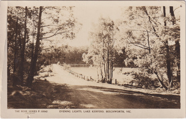
Photograph - Post Card, Rose Series Stereograph Co. Postcard
The construction on Lake Kerferd began in 1862 however it wasn't completed until 1874 due to engineering and funding issues. The lake was named after George Briscoe Kerferd (1831–1889) who was responsible for Beechworth's water scheme. George Briscoe Kerferd was born on 21 January 1831 in Liverpool, England and arrived in Melbourne April 1853. He spent his first years in Australia in Bendigo before settling down in Beechworth as a wine and spirits merchant. He married Ann Martindale on 17th December 1853 at St James Cathedral, Melbourne and between them they had three sons and five daughters. Kerferd began his political and legal career in Beechworth when he was first elected to the Municipal Council in May 1857. Later he would be elected to the Legislative Assembly for the Ovens District in November 1864, and continued to represent the area until February 1886. The postcard holds Historic significance due to its connection to Beechworth and its Lake Kerford. It demonstrates the interactions between nature and colonialists, especially how the lake has somewhat been 'protected' with the man made fencing. It also presents information on the environmental development or degradation for the area, with possible changes to the environment that may have been caused by human physical forces, natural decay or Global Warming.Sepia rectangular postcard printed on paper.Obverse: The Rose Series P. 10542 / Copyright / Evening lights, Lake Kerferd, Beechworth, VIC Reverse: Farley / Published by the Rose Stereograph Co., / Armadale Victoria. / 84-132-1 / Post card / The "Rose" Series De Luxe / A Real Photograph Produced in Australia / BMM299 lake kerferd, beechworth, water scheme, water reserve, reservoir, legislative assembly, hon. george briscoe kerferd, catchments, beechworth water reserve, beechworth catchments, municipal council, st. james cathedral, lakes, reserve, water supply, political projects, rose series, postcard, rose series stereograph -
 The Beechworth Burke Museum
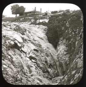
Photograph - Lantern Slide, c1900
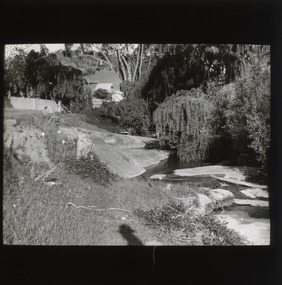
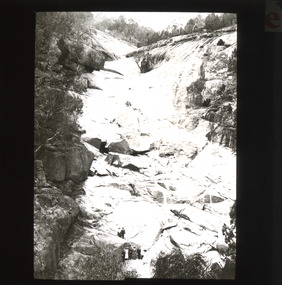
This image shows the gorge adjacent to Beechworth in approximately 1900. Although the exact location of the photograph is yet to be determined, the present-day Beechworth Gorge Walk includes views of the Cascades at the point at which Spring Creek flows into the valley on the level below. Gold-sluicing techniques in use in the town during periods of active gold extraction may have altered the landscape since the photograph was taken, however. In the 1850s a mill was built at the top of the Spring Creek falls by Russian-born Louis Chevalier, brother of artist Nicholas Chevalier. The mill supplied the town with lumber that supported the town's initial construction boom. Lantern slides, sometimes called 'magic lantern' slides, are glass plates on which an image has been secured for the purpose of projection. Glass slides were etched or hand-painted for this purpose from the Eighteenth Century but the process became more popular and accessible to the public with the development of photographic-emulsion slides used with a 'Magic Lantern' device in the mid-Nineteenth Century. Photographic lantern slides comprise a double-negative emulsion layer (forming a positive image) between thin glass plates that are bound together. A number of processes existed to form and bind the emulsion layer to the base plate, including the albumen, wet plate collodion, gelatine dry plate and woodburytype techniques. Lantern slides and magic lantern technologies are seen as foundational precursors to the development of modern photography and film-making techniques.This glass slide is significant because it provides insight into Beechworth's built environment and natural landscape in the early Twentieth Century, around the time of Australia's Federation. It is also an example of an early photographic and film-making technology in use in regional Victoria in the time period.Thin translucent sheet of glass with a square image printed on the front and framed in a black backing. It is held together by metals strips to secure the edges of the slide.burke museum, beechworth, lantern slide, slide, glass slide, plate, burke museum collection, photograph, monochrome, indigo shire, north-east victoria, spring creek falls, beechworth gorge, louis chevalier, nicholas chevalier, lumber industry, timber industry, 1850s, construction, building, mill, mills, waterfall -
 The Beechworth Burke Museum
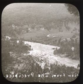
Photograph - Lantern Slide, c1900
This image shows a semi-aerial view of a property along a river adjacent to Beechworth in approximately 1900. The photographer has capitalised words in the label, indicating that 'The Precipice' may have suggested a particular rather than a general vantage point to local people at the time. Although the exact location of the photograph is yet to be determined, Beechworth Gorge is popular today with hikers and nearby Mt Stanley is noted for its views. Lantern slides, sometimes called 'magic lantern' slides, are glass plates on which an image has been secured for the purpose of projection. Glass slides were etched or hand-painted for this purpose from the Eighteenth Century but the process became more popular and accessible to the public with the development of photographic-emulsion slides used with a 'Magic Lantern' device in the mid-Nineteenth Century. Photographic lantern slides comprise a double-negative emulsion layer (forming a positive image) between thin glass plates that are bound together. A number of processes existed to form and bind the emulsion layer to the base plate, including the albumen, wet plate collodion, gelatine dry plate and woodburytype techniques. Lantern slides and magic lantern technologies are seen as foundational precursors to the development of modern photography and film-making techniques.This glass slide is significant because it provides insight into Beechworth's built environment and natural landscape in the early Twentieth Century, around the time of Australia's Federation. It is also an example of an early photographic and film-making technology in use in regional Victoria in the time period.Thin translucent sheet of glass with a square image printed on the front and framed in a black backing. It is held together by metals strips to secure the edges of the slide.Obverse: Image from The Precipice. /burke museum, beechworth, lantern slide, slide, glass slide, plate, burke museum collection, photograph, monochrome, views, landscapes, farmsteads, rivers, beechworth gorge, mt stanley, emulsion, the precipice -
 The Beechworth Burke Museum
Photograph - Lantern Slide, c1900
This image shows a view of a properties bordering a river in the vicinity of Beechworth in approximately 1900. Although the exact location of the photograph is yet to be determined, the water source pictured may feed into the bigger system that flows through Beechworth Gorge. A man wearing a hat, possibly the photographer, is silhouetted in the foreground of the picture. Lantern slides, sometimes called 'magic lantern' slides, are glass plates on which an image has been secured for the purpose of projection. Glass slides were etched or hand-painted for this purpose from the Eighteenth Century but the process became more popular and accessible to the public with the development of photographic-emulsion slides used with a 'Magic Lantern' device in the mid-Nineteenth Century. Photographic lantern slides comprise a double-negative emulsion layer (forming a positive image) between thin glass plates that are bound together. A number of processes existed to form and bind the emulsion layer to the base plate, including the albumen, wet plate collodion, gelatine dry plate and woodburytype techniques. Lantern slides and magic lantern technologies are seen as foundational precursors to the development of modern photography and film-making techniques.This glass slide is significant because it provides insight into Beechworth's built environment and natural landscape in the early Twentieth Century, around the time of Australia's Federation. It is also an example of an early photographic and film-making technology in use in regional Victoria in the time period.Thin translucent sheet of glass with a square image printed on the front and framed in a black backing. It is held together by metals strips to secure the edges of the slide.burke museum, beechworth, lantern slide, slide, glass slide, plate, burke museum collection, photograph, monochrome, photographer, beechworth gorge, river, stream, water source, 1900s -
 The Beechworth Burke Museum
Photograph - Lantern Slide, c1900
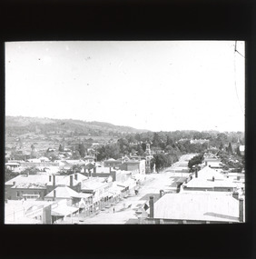
This image shows a semi-aerial view of commercial and official properties lining Ford Street, Beechworth, in approximately 1900. The tower of Christ Church of St Peter and St Paul can be seen in the middle section of the photograph, on the left-hand side of the street. The Church was constructed in 1858 with the tower added to the structure in 1864. Lantern slides, sometimes called 'magic lantern' slides, are glass plates on which an image has been secured for the purpose of projection. Glass slides were etched or hand-painted for this purpose from the Eighteenth Century but the process became more popular and accessible to the public with the development of photographic-emulsion slides used with a 'Magic Lantern' device in the mid-Nineteenth Century. Photographic lantern slides comprise a double-negative emulsion layer (forming a positive image) between thin glass plates that are bound together. A number of processes existed to form and bind the emulsion layer to the base plate, including the albumen, wet plate collodion, gelatine dry plate and woodburytype techniques. Lantern slides and magic lantern technologies are seen as foundational precursors to the development of modern photography and film-making techniques.This glass slide is significant because it provides insight into Beechworth's built environment and commercial and official infrastructure in the early Twentieth Century, around the time of Australia's Federation into one nation. It is also an example of an early photographic and film-making technology in use in regional Victoria in the time period.Thin translucent sheet of glass with a square image printed on the front and framed in a black backing. It is held together by metals strips to secure the edges of the slide.burke museum, beechworth, lantern slide, slide, glass slide, plate, burke museum collection, photograph, monochrome, ford street, christ church of st peter and st paul, church tower, landmarks, 1900, shopping facilities, public buildings, 1900s, built environment, streetscape -
 The Beechworth Burke Museum
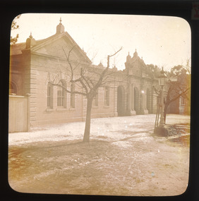
Photograph - Lantern Slide, c1900
This lantern slide shows the Ovens District Hospital (also called the Ovens Goldfields Hospital) in Beechworth in approximately 1900. The Hospital was built as part of a community push to develop the infrastructure needed for a permanent town in the 1850s. At the time there was no hospital located between Melbourne and the NSW town of Goulburn and it was recognised that the nature of mining and agricultural work predisposed people to serious injury. The community voted in 1853 to raise funds for a hospital and a voluntary committee elected from people who contributed £2 or more annually determined the organisation's management policies, which aimed to provide care for poor people at rates levied according to the person's means. Ongoing operations of the hospital were primarily supported by Government grants, however. The foundation stone was laid at a site in Church Street at a ceremony held 1st September 1856 which was attended by 2000 people using a locally crafted trowel with a tin ore handle and pure gold blade. The hospital, which was designed by J.H. Dobbyn, cost £2347. The hospital had two wards, a dispensary, apartments for a resident surgeon and the matron, an operating theatre and a board room. Further medical facilities including services to meet the cultural and health needs of the local Chinese community were later added, in addition to a Palladian-style cut-granite face built in 1862-63. It functioned as the region's primary hospital until surpassed by the Wangaratta Hospital in 1910. In the 1940s much of the building materials were salvaged and repurposed, with the exception of the facade which was restored in 1963 by the Beechworth Lions Club and still stands today. The facade featured on the covers of local history volume 'Beechworth: a Titan's Field' by Carole Woods and heritage-focused travel guide the 'Readers Digest Book of Historic Australian Towns'. Lantern slides, sometimes called 'magic lantern' slides, are glass plates on which an image has been secured for the purpose of projection. Glass slides were etched or hand-painted for this purpose from the Eighteenth Century but the process became more popular and accessible to the public with the development of photographic-emulsion slides used with a 'Magic Lantern' device in the mid-Nineteenth Century. Photographic lantern slides comprise a double-negative emulsion layer (forming a positive image) between thin glass plates that are bound together. A number of processes existed to form and bind the emulsion layer to the base plate, including the albumen, wet plate collodion, gelatine dry plate and woodburytype techniques. Lantern slides and magic lantern technologies are seen as foundational precursors to the development of modern photography and film-making techniques.This glass slide is significant because it provides insight into Beechworth's built environment and infrastructure in the early Twentieth Century, around the time of Australia's Federation. It is also an example of an early photographic and film-making technology in use in regional Victoria in the time period.Thin translucent sheet of glass with a round-edged square image printed on the front and framed in a black backing. It is held together by metal strips to secure the edges of the slide.Obverse: Y /burke museum, beechworth, lantern slide, slide, glass slide, plate, burke museum collection, photograph, monochrome, ovens district hospital, indigo shire, north-east victoria, hospital, palladian architecture, granite, community fundraising, community infrastructure, j.h. dobbyn, beechworth lions club, ovens goldfields hospital, chinese community -
 The Beechworth Burke Museum
Photograph - Lantern Slide, c1900
This image shows the gorge adjacent to Beechworth in approximately 1900. Although the exact location of the photograph is yet to be determined, the present-day Beechworth Gorge Walk includes views of the Cascades at the point at which Spring Creek flows into the valley on the level below. Gold-sluicing techniques in use in the town during periods of active gold extraction may have altered the landscape since the photograph was taken, however. In the 1850s a mill was built at the top of the Spring Creek falls by Russian-born Louis Chevalier, brother of artist Nicholas Chevalier. The mill supplied the town with lumber that supported the town's initial construction boom. Lantern slides, sometimes called 'magic lantern' slides, are glass plates on which an image has been secured for the purpose of projection. Glass slides were etched or hand-painted for this purpose from the Eighteenth Century but the process became more popular and accessible to the public with the development of photographic-emulsion slides used with a 'Magic Lantern' device in the mid-Nineteenth Century. Photographic lantern slides comprise a double-negative emulsion layer (forming a positive image) between thin glass plates that are bound together. A number of processes existed to form and bind the emulsion layer to the base plate, including the albumen, wet plate collodion, gelatine dry plate and woodburytype techniques. Lantern slides and magic lantern technologies are seen as foundational precursors to the development of modern photography and film-making techniques.This glass slide is significant because it provides insight into Beechworth's built environment and natural landscape in the early Twentieth Century, around the time of Australia's Federation. It is also an example of an early photographic and film-making technology in use in regional Victoria in the time period.Thin translucent sheet of glass with a square image printed on the front and framed in a black backing. It is held together by metals strips to secure the edges of the slide.burke museum, beechworth, lantern slide, slide, glass slide, plate, burke museum collection, photograph, monochrome, beechworth gorge, indigo shire, landscapes, mill, sluicing, gold mining, north-east victoria, spring creek, louis chevalier, cascades -
 The Beechworth Burke Museum
Photograph - Lantern Slide, c1900
Miners from Snake Valley lobbied the Victorian Government in 1855 to make land available for sale for farming purposes as an alternative occupation and income for people who wished to stay in the region but move away from gold mining. A secondary motivation was to increase the supply of fresh produce and decrease prices of items that otherwise needed to be transported from Melbourne or other regions. Forty-three country lots were initially offered in the Three Mile area, ranging in size from two to ninety acres and costing from £1 to £3 per acre. An additional eighty-five country lots were auctioned later in the year, in addition to many smaller suburban lots. More lots were offered than sold, initially, but this represented conditions of sale requiring the total purchase cost up front which many people interested in purchasing could not afford, especially as land purchased for farming would accrue substantial additional costs for clearing and labour before becoming productive. Further lobbying activities and the election of parliamentary members sympathetic to the cause took place through the 1850s. Ovens Parliamentary Member, Daniel Cameron, was re-elected in 1856 on a platform of surveying the land for public selection with deferred payment options. Land reform remained an issue in the area through the 1850s and early 1860s, impacting broader decisions in the new State of Victoria relating to voting rights, use of Crown land and the farming of land that wasn't always suitable for the purpose. This photograph depicts Beechworth in approximately 1900, after several waves of land sales resulted in increasingly levels of development. Lantern slides, sometimes called 'magic lantern' slides, are glass plates on which an image has been secured for the purpose of projection. Glass slides were etched or hand-painted for this purpose from the Eighteenth Century but the process became more popular and accessible to the public with the development of photographic-emulsion slides used with a 'Magic Lantern' device in the mid-Nineteenth Century. Photographic lantern slides comprise a double-negative emulsion layer (forming a positive image) between thin glass plates that are bound together. A number of processes existed to form and bind the emulsion layer to the base plate, including the albumen, wet plate collodion, gelatine dry plate and woodburytype techniques. Lantern slides and magic lantern technologies are seen as foundational precursors to the development of modern photography and film-making techniques.This glass slide is significant because it provides insight into Beechworth's built environment and infrastructure in the early Twentieth Century, around the time of Australia's Federation. It is also an example of an early photographic and film-making technology in use in regional Victoria in the time period.Thin translucent sheet of glass with a square-edged image printed on the front and framed in a black backing. It is held together by metal strips to secure the edges of the slide.burke museum, beechworth, lantern slide, slide, glass slide, plate, burke museum collection, photograph, monochrome, indigo shire, north-east victoria, farming, squatters, miners, agriculture, land-clearing, land reform, daniel cameron, land sales, three mile, snake valley, tarrawingee -
 Orbost & District Historical Society
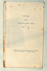
booklet, A Brief History of the Brass Bands of Orbost Australia 1889-1975, 8.11.1975
This booklet was compiled for the anniversary celebrations of the Orbost Municipal Band on November 8, 1975. It was compiled by Peter Fagg who worked as a scientist with the Department of Sustainability and Environment (now DELWP) to study dieback in eucalypts. He specialised in the silviculture of the eucalypt forest types of South-East Australia for most of his 40-year career, which started with the Forests Commission Victoria. He was in Orbost from 1968 - 1973. The first Orbost Brass Band was formed in 1889. Around 1908 the town band split and the Orbost Workers' Band was formed. Eventually the two bands merged in 1913 to reform as the Orbost Municipal Band under conductorship of Charles Spink. The band continued for many years but was later disbanded and again reformed. This was to happen a number of times, the last time being in 1961 and continuing through to the late 1970's. Further info and Ref: In Times Gone By - Deborah HallThe various Orbost bands over the years played a major role in community activities providing entertainment and musical experiences for the many members.A 12 pp stapled booklet compiled for the anniversary celebration of the Orbost Municipal Band. It has been typed in black ink on foolscap sized white paper.orbost-municipal-band music-orbost fagg-peter -
 Orbost & District Historical Society
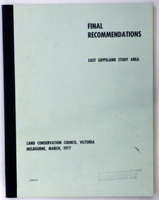
document, FINAL RECOMMENDATIONS E. GIPPSLAND STUDY AREA - LAND CONSERVATION COUNCIL, VICTORIA March 1977, March 1977
Established in 1971, the Land Conservation Council operated under the Land Conservation Council Act 1970. In July 1997, the Environment Conservation Council Act 1997 came into operation. This Act revoked the Land Conservation Council Act 1970 and abolished the Land Conservation Council. An Environment Conservation Council was established in its place. (ref. TROVE) This document is a useful reference tool.A document of 75 pp with a pale green cover and black print, titled Final Recommendations East Gippsland Study area. Land Conservation Council, Melbourne, March, 1977.land-conservation-east-gippsland -
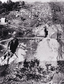
 The Beechworth Burke Museum
Photograph - Photograph - Reproduction
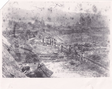
This photograph depicts mining operations within the Beechworth area, in an unidentified valley where sluicing was utilised as a method for extracting gold from the environment. After gold was discovered in the region in 1851, sluicing became a characteristic of gold mining in the region - "Ovens miners carved intricate networks of races" throughout the region - involved the diversion of water in many channels, or water races, which contained inbuilt 'ripple devices' designed to trap gold for later extraction. By 1871, 900 miles of water races had been cut into the Beechworth Mining District. As suggested by the numerous figures involved in labouring along the water race, sluicing was a source of considerable employment within the region. This image is of important historical significance for its ability to convey information about sluicing and the methods used to find gold in the 1850s, and provides clues as to how sluicing and the widespread construction of water ranges changed the environment of the region. This image is important for current research into the history of the Ovens region in Victoria, which played such a prominent role in the early Australian gold mining industry. Therefore, this image has the capacity to be beneficial for research into society and the motivations of those living and working in this region during this period and therefore, has social significance. The Beechworth Burke Museum has additional images relating to gold sluicing and and the mining activities in the area more generally, which can be analysed and studied alongside images like this one.A black and white rectangular photograph printed on matte photographic paperbeechworth, mining, miners, labour, water race, sluicing -
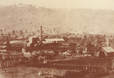
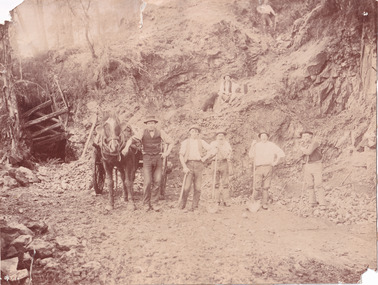 The Beechworth Burke Museum
Photograph
This photograph depicts a reef mine in Beechworth. Reef mining, or quartz reef mining, was common in 19th Century Victoria. This gold mining technique requires mine shafts to be sunk into underground quartz reefs, with horizontal tunnels dug from the original shaft at differing levels to find the gold-bearing rock. The quartz would then be hoisted to the surface, which would then be pounded to access the gold in its metallic state. Gold was discovered in Beechworth in February 1852, at Spring Creek. Within 11 months of that discovery, over 8000 hopeful prospectors quickly descended on this region, transforming it into a thriving, wealthy township. Reef mining and hydraulic sluicing were gold mining techniques used in this region in the 19th and early 20th centuries. This photograph interestingly contains dogs alongside the miners. While dogs have been recorded as deterrents to thieves in the Victorian goldfields, these dogs appear as companions to these men.The search for gold is ingrained into the history of Victoria and therefore, images like this one can reveal important information for society and technology for the date when the photograph was taken. It also shows a location where reef mining was undertaken which provides insight into the impact on the environment at a time when it was done. Although quartz is one of the most common minerals found in the earth's crust, it does not always contain gold. Those reefs that do are rare and highly sought after by prospectors. The Beechworth Burke Museum has additional images relating to gold mining which can be analysed and studied alongside images like this one.Sepia coloured rectangular photograph printed on gloss photographic paper. Obverse: Reverse: United Shire of Beechworth/ Shire Secretary/ Reef Mining, Beechworth./ 6167.abeechworth, burke museum, gold, gold mining, gold rush, victorian gold rush, reef mining, quartz, companion dog, horse and cart -
 The Beechworth Burke Museum
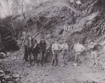
Photograph - Photograph - Reproduction
This reproduced photograph depicts a reef mine in Beechworth. Reef mining, or quartz reef mining, was common in 19th Century Victoria. This gold mining technique requires mine shafts to be sunk into underground quartz reefs, with horizontal tunnels dug from the original shaft at differing levels to find the gold-bearing rock. The quartz would then be hoisted to the surface, which would then be pounded to access the gold in its metallic state. Gold was discovered in Beechworth in February 1852, at Spring Creek. 8000 hopeful prospectors quickly descended on this region within the year, transforming it into a thriving, wealthy township. Reef mining and hydraulic sluicing were gold mining techniques used in this region in the 19th and early 20th centuries. This reproduction photograph interestingly contains dogs alongside the miners. While dogs have been recorded as deterrents to thieves in the Victorian goldfields, these dogs appear as companions to these men.The search for gold is ingrained into the history of Victoria and therefore, images like this one can reveal important information for society and technology for the date when the photograph was taken. It also shows a location where reef mining was undertaken which provides insight into the impact on the environment at a time when it was done. The Beechworth Burke Museum has additional images relating to gold mining which can be analysed and studied alongside images like this one.Black and white rectangular reproduction photograph on gloss photographic paper. Obverse: Reverse: L is miners 26%/ 10 x 8/ 6167.bbeechworth, burke museum, gold, gold mining, gold rush, victorian gold rush, reef mining, quartz, companion dog, horse and cart