Showing 163 items
matching farmland
-
 National Wool Museum
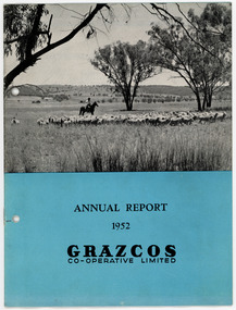
Document - Grazcos Annual Report, Grazcos Co-operative Limited, 1952
The co-operative was registered in 1919 as the Graziers Co-op Shearing Company Limited. It changed its name in September 1948 to Grazcos Co-operative Ltd. In 1981 the co-operative merged with Farmers & Graziers Co-op Ltd to form Farmers Grazcos Co-op Ltd. This item is part of a collection of Annual Reports from Grazcos dated from 1949 - 1980.Booklet featuring a black and white image of sheep, a man on horseback and farmland, with printed black text on blue background below image.front: ANNUAL REPORT / 1952 / GRAZCOS / CO-OPERATIVE LIMITEDagricultural co-operative, agricultural wholesaling, annual reports, rural life, rural industry, business, corporate body -
 Kew Historical Society Inc
Photograph - Studley Park, 1937
Those sections of Studley Park closest to the River Yarra were set aside as parkland in the 1850s. After initial discussions about whether it was a suitable site for a Government House, much of the land was instead gazetted in the 1860s as the location for a new lunatic asylum, to expand overcrowded mental health facilities at the Yarra Bend Asylum on the other side of the river at Fairfield. Those sections of Studley Park bounded by the Yarra River, Studley Park Road, Princess Street and Fellows Street were subdivided and sold at the Crown Land Sales in 1851. Much of this urban area remained open farmland until the twentieth century, apart from mansions, largely located along the main roads.Original, black and white positive print of what is said to represent Studley Park in 1937. If the attribution and date is literally to be understood, then it would appear that the photograph may have been taken from the Kew side of the river looking across to open farmland in the Yarra Bend Park. If the designation of Studley Park is to be understood more loosely, then it might be a view of what is now East Kew, taken from a section of Kilby Road. Inscribed verso: "Studley Park 1937" studley park -- kew (vic.) -
 Phillip Island and District Historical Society Inc.
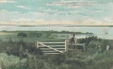
Photograph - Post Card, Early 1900's
One of a collection of photographs donated by Shirley Peterson.Colour postcard of farmland in foreground looking across Westernport from Rhyll. French Island in the distance. Man standing on fence beside gate."Westernport from Rhyll, looking North, French Island in Middle Distance." "Robb Bros. Cowes" On back a letter from M Evans of Ventnor to ?? in Ascot Vale.rhyll farmland phillip island, westernport bay, phillip island, shirley peterson -
 Phillip Island and District Historical Society Inc.
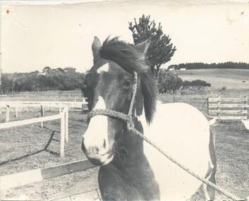
Photograph, 1920-30
Donated by Jessie Smith (nee Small)Black & White photograph of "painted" pony held in rope halter in horse training ring somewhere in San Remo. Trees, farmland and buildings in background. horse, jessie smith, phillip island -
 National Wool Museum
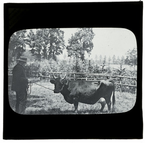
Photograph - Man with a Cow, J W Allen, 1900 - 1940
This item is part of a collection of twenty black and white glass lantern slides previously housed together in an old cardboard box. [8611 - 8630] The slides are part of a greater collection of around forty three black and white glass lantern slides, along with other photographs and photo albums related to this collection. This item is associated with the New South Wales Graziers Association world tour of merino sheep 1928/9. The slides were possibly used as supporting material in presentations made by J W Allen when on tour.Black and white glass lantern slide with paper edging depicting a man holding a horned cow with a rope. A fence, trees and farmland is shown in the background.front: [printed] MAKERS / NEWTON & Co. / 3 FLEET St. LONDON / [handwritten] Werlir[?] Herry[?] Cownew south wales graziers association, travel, cattle, agriculture, j w allen, photography, glass lantern slide -
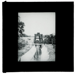 National Wool Museum
Photograph - Water Channel, J W Allen, 1900 - 1940
This item is part of a collection of seven black and white glass lantern slides previously housed together in a glass plate box. The slides are part of a greater collection of around forty three black and white glass lantern slides, along with other photographs and photo albums related to this collection. This item is associated with the New South Wales Graziers Association world tour of merino sheep 1928/9. The slides were possibly used as supporting material in presentations made by J W Allen when on tour.Black and white glass lantern slide with paper edging showing a water channel surrounded by farmland. A wooden structure is shown above the water channel.agriculture, new south wales graziers association, travel, sheep, breeding, photography, glass lantern slides, j w allen -
 Orbost & District Historical Society
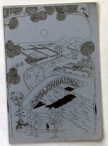
book, Croajingalong 1987, 1987
The name Croajingolong derives from the Australian Aboriginal Krauatungalung words galung, meaning "belonging to" and kraua, meaning "east". This is the thirty-ninth edition of the annual magazine of Orbost High School. The magazine belonged to Mary Gilbert, a former teacher at the school. Orbost High School / Orbost Secondary College has played a significant part in the education of senior students in the Orbost district . It is the sole senior educational institution. This item is representative of its history. This 39th edition of the magazine is a useful reference tool.A magazine type publication, titled Croajingalong. It has 84 pp. The cover is pale blue with black print drawings of a river, bridge, farmland,trees and buildings.magazine-croajingalong orbost-high-school -
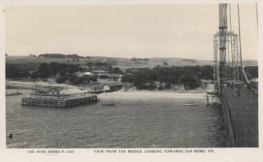 Phillip Island and District Historical Society Inc.
Photograph - Post Card, Early 1900's
Donated by Edith ElmsBlack & White Postcard of view from Suspension Bridge between San Remo and Newhaven. Bridge on right and San Remo Jetty on the left. Houses and farmland of San Remo in background."The Rose Series P. 3460. View from the bridge, looking towards San Remo, Vic."suspension bridge san remo/phillip island, san remo jetty, phillip island, edith elms -
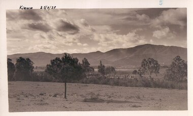
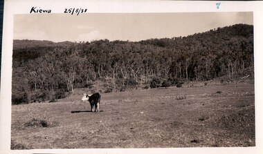 Kiewa Valley Historical Society
Black and white photograph of farmland, Kiewa, 25/8/38, circa 1938
This photograph was taken in August, 1938, some eight years prior to the establishment of Mt. Beauty a a township. The area was still being used for grazing, and the land was eventually acquired from the local land owners by the State Electricity Commission. The construction of the road, from Tawonga to the High Plains, was commenced in April, 1938 and this photograph was taken August, 1938. This allowed men and heavy equipment to be transported to the work sites for the construction of the Kiewa Hydro Electric Scheme. Prior to this access was by bridle trail, either on horse back or on foot. By 1946 housing construction had commenced for the new town of Mt. Beauty and by 1948 street construction in the southern part of the town was completed as far as Hill Street.This photograph is important as it shows the upper Kiewa Valley as it was before the establishment of the town of Mt. Beauty. The land has been cleared of natural vegetation to allow grazing of cattle. Black and white photograph of grazing farmland with one animal standing in the paddock. The area could possibly be where the golf course now stands with the road to the high plains not yet commenced.Handwritten in the upper left hand corner 'Kiewa 25/8/38'. The number 7 has been stamped in the upper right hand corner. It is part of a set of 8 photographs. On the back are the words Velox repeated several times, indicating the type of photographic papergrazing, kiewa, mt. beauty, secv -
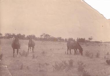 Phillip Island and District Historical Society Inc.
Photograph, Anderson Family, 1890
Horses of Robert Anderson Snr. on farmland - grazingThree brown horses grazing on farmlocal history, photography, photographs, slides, film, horses, sepia photograph, mrs emma anderson jacobs -
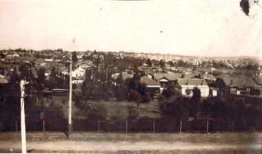 Kew Historical Society Inc
Photograph - Panoramic view of Kew East, 1927
This is one of two photographs of the same view in the collection. The other purports to be taken in 1925 whereas this photo has an inscription dating it to 1927. East Kew was the last section of Kew to be developed following subdivision of the large estates and former farmland in the first half of the twentieth century. The centre of the photograph would appear to show the trees of the Boroondara cemetery.Inscribed verso: "East Kew 1927" kew east (vic.), panoramic photos -- kew (vic.) -
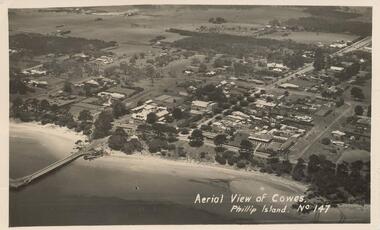 Phillip Island and District Historical Society Inc.
Photograph - Post Card, Early 1900's
Photograph donated by Les JonesBlack & White postcard of an aerial view of Cowes. Jetty on the left - tree lined Thompson Avenue - Isle of Wight Hotel on the Esplanade left of Thompson Avenue and Bayview Guesthouse on the right on the Esplanade. Township and farmland."Aerial View of Cowes, Phillip Island. No. 147"aerial view of cowes phillip island, cowes township, part cowes township - cowes beach and jetty, phillip island, les jones -
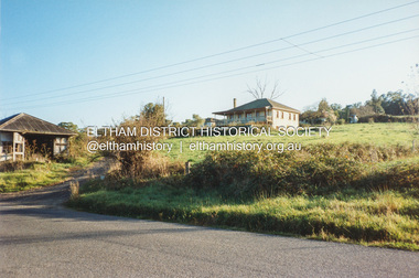 Eltham District Historical Society Inc
Photograph, Fay Bridge, Fabbro's farm, Bell Street, Eltham, 1994
Fabbro's farmland immediately prior to housing estate development in 1994fay bridge collection, 1994, bell street, eltham, fabbro farm, fabbro home, porter street -
 Greensborough Historical Society
Slide - Photograph, John Ramsdale, Residential development south of Whittlesea: Slide 92, 1990s
Photograph shows residential development south of Whittlesea encroaching on farmland.Part of the John Ramsdale collection of slides and audio visual material.Colour photograph scanned from slide.No maker's marks. No caption on slide.whittlesea, residential development -
 Greensborough Historical Society
Slide - Photograph, John Ramsdale, South of Yan Yean: Slide 88, 1990s
Photograph shows rural farmland with trees in background, South of Yan YeanPart of the John Ramsdale collection of slides and audio visual material.Colour photograph scanned from slide.No maker's marks. No caption on slide.yan yean -
 Greensborough Historical Society
Slide - Photograph, John Ramsdale, Flood plain of the Plenty River: Slide 90, 1990s
Photograph shows farmland on the flood plain of the Plenty River, north of MerndaPart of the John Ramsdale collection of slides and audio visual material.Colour photograph scanned from slide.No maker's marks. Caption on slide "Plenty"plenty river, mernda -
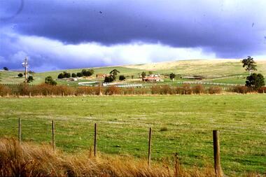
 Ballarat Heritage Services
Photograph - Photograph - Colour, Coimodai near Bacchus Marsh, 2007, 04/03/2007
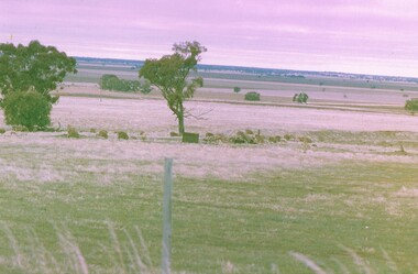
Coimodai is in the vicinity of Bacchus Marsh, VictoriaA number of photos taken to create a 360 degree view of Coimadaicoimodai, farmland, landscape -
 Bendigo Historical Society Inc.
Photograph - NORM GILLIES COLLECTION: PHOTOGRAPH OPEN FARM LAND
coloured photograph of open farm land Rear note: Donald Gillies and his brothers, sister grew up in this farmland. Donald was the father of three brothers who started Gillies Pies (in Bendigo). Alan, Norman, Leslie. -
 Lakes Entrance Regional Historical Society (operating as Lakes Entrance History Centre & Museum)
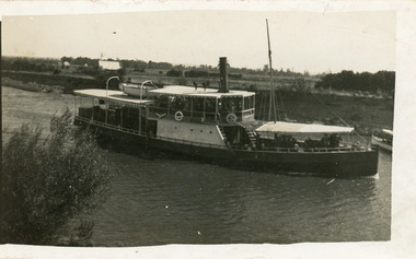
Photograph - S.S. Dargo, 1910 c
Also one enlargement black and white 16 x 25.5 cmBlack and white photograph showing steamer Dargo proceeding along the Sale Canal. Shows houses in left background and front of smaller boat on right side, farmland in background, bush on bottom left of photo. Sale Victoriajetties, ships and shipping, waterways -
 Kew Historical Society Inc
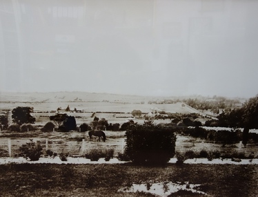
Photograph - East Kew, Looking Towards Balwyn, 1910-1930
Until post war subdivisions much of Balwyn and the eastern sections of Kew were rural farmlandVery large framed photographic enlargement of rural areas of East Kew. farmland (kew), kew farmland, farms, kew -
 Greensborough Historical Society
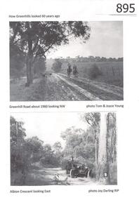
Photograph, Greenhills circa 1960, 1960c
The Greenhills area of Greensborough is now a suburban area. These photographs, taken in the 1960s, show it as open bush and farmland. Greenhills is designated a 'semi-bush precinct' by Banyule Council, due to its vegetation and large blocks of land.Copies of 4 black and white photographs.Captions identify each location and the photographer.greenhills, semi-bush precinct, tom young, joy darling, greenhill road, albion crescent -
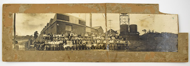 National Wool Museum
Photograph - Staff Group Portrait, Collins Bros Mill Pty Ltd, 1930s-1940s
The Collins No. 2 Woollen Mill building dates from around the 1930s, however related buildings at that site were first constructed from around 1918, that was the Marnock Vale Wool Scouring Works. The Union Woollen Mill founded in the 1870s by William Henry Collins, a major Geelong industrial enterprise, was among the local firms which flourished during the First World War period. From 1914-1918 Collins Bros. concentrated on equipment for the A. I. F. However, afterwards Collins Bros. Pty. Ltd. specialised in the manufacture of flannels and blankets. From 1920 to 1938 the output was increased by fifty percent, and the number of employees rose to 200. The Collins Bros. No. 2 Mill was established in Bridge Street, Newtown. The proprietary brand 'Physician' became well and favourably known throughout Australia source: Heritage Victoria The Collins Bros Mills No. 1 and No. 2 hired over 250 people, and produced between 40,000 and 60,000 blankets for both the Australian market and for overseas export. Collins Bros closed both mills in 1974.Landscape photograph mounted on board showing a group portrait of staff seated and standing together in front of the Collins No. 2 Woollen Mill, Bridge Street, Newtown. Buildings, a chimney, towers, tanks, farmland, a car, powerlines and dirt roads are shown in the background. -
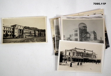 Bendigo Military Museum
Photograph - PHOTOGRAPHS, HIROSHIMA, BCOF, C.1944 - 47
Items in the collection re Clarence Shearing, refer Cat No 7089.16P for his service details.Photographs B & W eleven in total re BCOF Japan. Six photos are of damage to Hiroshima, two have text on. Two photos of a harbour. One X Hiroshima Railway station pre bombing. One X Hospital. One X Farmland.photographs, hiroshima, bcof -
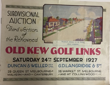 Kew Historical Society Inc
Booklet, Duncan & Weller Pty Ltd, Old Kew Golf Links Estate, 1927, 1927
The booklet advertises the third sale within the Old Golf Links Estate which was a major subdivision of farmland in North Kew in the 1920sThe subdivision of the Kew Golf Links Estate was a major subdivision of farmland in Kew. The site was at one stage designated for industrial development and the building of a new Kodak factory. The decision by Council to oppose the redevelopment makes the beginning of the period when all industrial development was banned in Kew.6 page illustrated brochure advertising the third section of a major subdivision in Kew in 1927 including 75 charming home allotments and 7 valuable building sites. The brochure includes the subdivision plan. The front cover includes a colour illustration of the almost completed houses in Woolcock Avenue. Streets named include: Kilby Road, Kodak Avenue, Baker Avenue, Mathers Avenue, Coleman Avenue, White Avenue and Belford Road. Lots for sale are numbered. Existing buildings are designated with a square.subdivisions - kew (vic), kew golf links estate -
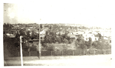 Kew Historical Society Inc
Photograph - Panoramic view of Kew East, 1925
East Kew was the last section of Kew to be developed following subdivision of the large estates and former farmland in the first half of the twentieth century. Original, black and white positive panorama of East Kew in 1925. By the mid 1920s, the area was already highly urbanised with core utilities such as electricity installed. Inscribed verso: "East Kew 1925" kew east, urbanisation -- 1920s -
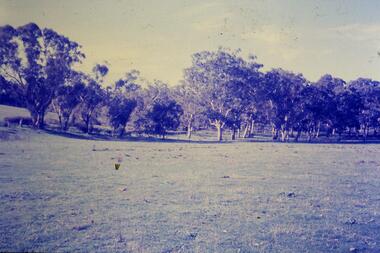
 Federation University Historical Collection
Negative, Townscapes
Large format negative transparencies.townscape, farmland, mount buninyong, mount warrenheip -
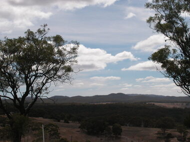
 Port Fairy Historical Society Museum and Archives
Photograph
South Beach DevelopmentColoured photograph of Hills above South Beach Estate looking to seasouth beach, development, west, farmland -
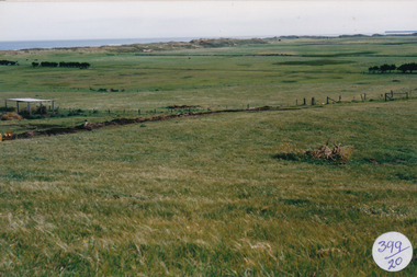
 Greensborough Historical Society
Newspaper Clipping, Diamond Valley Leader, From humble start to learning powerhouse, 24/10/2018
La Trobe University - Once a sparse farmland and filled with more kangaroos than classmates, Bundoora is on its way to become an educational and industrial powerhouse.News article 1 page, black text and colour image .latrobe university, bundoora -
 Kiewa Valley Historical Society
Black and white photograph of farmland, Kiewa, 25/8/38, circa 1938
This photograph was taken in August, 1938 some eight years prior to the establishment of Mt. Beauty as a township. The area was still being used for grazing, and the land was eventually acquired from the local land owners by the State Electricity Commission. The construction of the road, from Tawonga to the High Plains, was commenced in April of this year. This allowed men and heavy equipment to be transported to the work sites for the construction of the Kiewa Hydro Electric Scheme This photograph is important as it shows the upper Kiewa Valley as it was before the establishment of the town of Mt. Beauty. The land has been cleared of natural growth and has been used for grazing cattle. By 1946 housing construction had commenced for the new town of Mt. Beauty and by 1948 street construction in the southern part of the town was completed as far as Hill Street.A black and white photograph of farmland with Mt. Emu in the background. This has been taken from where Mt. Beauty township now stands prior to road making and the erection of houses. A line of trees below the hill line indicates the position of the East Kiewa River. (No. 5 in a set of 8) Handwritten in black ink on the upper left corner of the photograph is the inscription 'Kiewa 25/8/38' and the number 5 has been stamped on the upper right hand corner. On the back is the word 'Velox' which is the name of the photographic paper on which the photo was developed.road construction, kiewa, tawonga, mt. beauty, secv -
 Kew Historical Society Inc
Photograph - Grounds of the Yarra Bend Asylum, 1924
Henry Beater Christian (1886-1962) , was a descendant of one of the earliest settler families in Kew. Employed at the Kew Asylum as a 'public servant', he was a skilled amateur photographer, photographing numerous scenes in Kew and on his travels around Victoria. The majority of his photographs date from 1916 to 1929. His finest photographs are housed in two photograph albums. Digital copy of a photograph from page 6 of the 47-page photograph album containing 261 gelatinous silver images, loaned by Diane Washfold with permission given to digitise and hold a copy in our collection. This is a photograph of the extensive grounds of the Yarra Bend Asylum which were used as farmland."Yarra Rvr / Kew"henry beater christian (1886-1962), landscape photography, kew (vic.) — yarra river, christian-washfold collection, photograph albums, yarra bend asylum