Showing 53 items matching "geographical names"
-
 Bendigo Historical Society Inc.
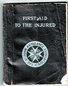
Book - First Aid to the Injured - The St John Ambulance association, 1942
The St John Ambulance Association, which was founded in 1877 in England. Its first uniformed first-aiders were founded in 1887 as the St John Ambulance Brigade. These two have since been merged into a single association. St John Ambulance now have over 40 national organisations, many of which are affiliated with Johanniter International, and over 300,000 volunteers worldwide. The Order of St John owns the brand name in most countries (with the notable exception of India, which has a St John Ambulance organisation that is unconnected to the international movement). Logos vary in different countries but always contain the eight-pointed white Maltese cross as the essential identifier. Like the Order, St John Ambulance associations accept members of all religions. Their geographic organisation differs from the Order, and they have to contend with the differing national laws, medical practices and cultures of countries. As a result, the role and organisation of St John Ambulance varies by country.Joan Filbey Collection: Book First Aid to the Injured - The St John Ambulance association. The book is a copy of the Thirty-ninth edition first impression (1942), Price 2/6 net; by post, 2/8. The book is published by the St John Ambulance Association (Victoria Centre) 217 Lonsdale Street Melbourne. Inside Front Cover - a sketch of a skeleton along with arteries and bones marked. It is sttsched to the cover by masking tape. Written in ink is "Maxwell A. Roberts, SEC Bendigo"history, bendigo, joan filbey collection, st john ambulance, first aid book, maxwell roberts -
 Bendigo Historical Society Inc.
Book - NORMAN WARNE EXERCISE BOOK
Black exercise book, on inside cover the name Norman Warne age 12 years. The book contains the home work from September 20th, 1904 to April 26th, 1906. Subjects: arithmetic, geography, grammar, writing, sums, questions, history, spelling, analysis.person, individual, norman warne -
 Bendigo Historical Society Inc.
Document - MAJOR MITCHELL AND MOUNT ALEXANDER
Typed notes mentioning the naming of Mount Alexander, Coliban, Campaspe and who named them. Also the origins of the names.document, major mitchell and mount alexander, tommy-came-last, the major mitchell tourist trail, major general john byng, phillip of macedonia, alexander the great, henty s, surveyor davidson, alexander mollison, george augustus robinson, william morton, mr charles hotson ebden, john randell, public library of melbourne, les blake, governor burke, phillip parker king, crown solicitor henry field gurner, arthur phillip, hume, australia felix expedition, l blake, place names of victoria, g brenmer, booklet for secondary schools, m cannon, historical records of victoria vol 1, j h l cumpston, thomas mitchell surveyor general and explorer, h f gurner, chronicle of port phillip, t l mitchell, three expeditions into the interior of eastern australia, a f mollison, an overlanding diary, w l morton, adventures of a pioneer, m s 5188, itinerary from the journal of the exploring expedition returning from portland bay, m s 5189, mitchell's 1837 map, j o randell, pastoral settlement in northern victoria vol 1, pastoral settlement in northern victoria vol 2, records of the victorian archaeological survey number 5, journals of george augustus robinson, t c sargent, some peninsular names in australia felix, w h wells, a geographical dictionary or gazetteer of the australian colonies -
 Victorian Aboriginal Corporation for Languages
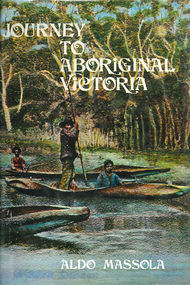
Book, Aldo Massola, Journey to Aboriginal Victoria, 1969
Looks at the Aboriginal community from the time of white contact, across many parts of Victoria. Chap.1; Melbourne - early missions, camp of Native Police, corroboree trees, canoe trees, grave &? headstone of Derrimut; quarries at Keilor, excavation sites at Green Gully &? Keilor; quarry at Mt. William, notes on inheritance of quarries Coranderrk settlement - Barraks grave, notes on his life; Chap.2; Geelong - Yawangi group of the Wothowurong tribe, camping grounds in area quarries; Notes on William Buckley, Gellibrand (a notable Aboriginal), graves in the Western Cemetery; Chap.3; Colac - war between Colac &? Geelong tribes; Mission at Birregurra, reason for failure of Buntingdale Mission; brass plate to Coc-coc-coine; reserve at Elliminyt, native ovens, camp sites, initiation site &? ritual; quarry sites, axegrinding factory, rock pecking &? engraving; dried hand &? 3 Aboriginal skulls found; Chap.4; The south-west coast - middens, camp sites notes on Framlingham Stn., fish traps at Tyrendarra; Chap.5; The far west - massacres of Aborigines near Casterton; camp sites, oven mounds; the first cricket team formed; Aboriginal cemetery; Chap.6; Hamilton - camps; Mount Rouse Station, axegrinding grooves at Nareeb Nareeb, shelters described, fish traps, massacre at Lake Condah; mission; canoes; Chap.7; Camperdown - legend about Lake Bullen Merri; obelisk erected in memory of Aborigines of district especially chief Wombeetch Puyuun; Jarcoort tribe; fish weirs, camps, intertribal fights between Booluc-burrers, Jarcoorts &? Ellengermote groups; bartering place at Mount Noorat; articles traded, legend of Flat-Top Hill; Chap.8; Ballarat - camp at Lake Wendouree; White Stone Lagoon; legends concerning Mt. Buninyong &? waterfalls at Lal-lal; camp sites; pygmy-type implements near Meredith, quarry at Glue Pot Rocks near Durdidwarrah; brass plate of King Billy; Chap.9; Ararat - Tjapwurong territory; camp sites, quarries, shield &? canoe trees; Bunyip belief at Lake Buninjon of Muk-jarawaint &? Pirtkopen-noot tribes, gives legend; stone implements; mill stones; fish weirs; stone arrangement near Lake Wongan; ground drawing of a bunyip, paintings in rock shelter near Mt. Langi Ghiran; Chap.10; Maryborough - camps, oven mounds, rock wells, stone arrangement at Carisbrook; camp sites at Mt. Franklin; Chap.11; Charlton - belief in Mindye (snake); canoe trees, ovens, camp sites, water holes, rock wells, stone implements; method of rainmaking; Chap.12; Horsham-Stawell, The Wimmera - Wotjobaluk land; camps, fish traps at Toolondo; Black Range cave paintings, Flat Rock shelters (detailed account of these paintings); Bunjils Cave; Chap.13; Horsham-Stawell, The Mallee - camp sites, implements; Ebenezer Mission, Willie Wimmera taken to England by Rev. Chase to become a missionary, died in England; Chap.14; The Murray River, Mildura Swan Hill - Battle of the Rufus; ceremonial ground, Lake Gol Gol, canoe &? shield trees; stone implements; camp sites, fire place arrangements; fish traps; oven mounds; Chap.15; The Murray River, Swan Hill-Echuca - legend about Lake Boga; camps, oven mounds, the Cohuna skull, Kow Swamp, method of burial; Chap.16; Shepparton ovens; brass plates of King Paddy of Kotupna &? King Tattambo of Mulka Stn., native well, camps; Chap.17; Wangaratta -camps, quarry, rock holes, the Faithful massacre; grinding rocks at Earlston; Chap.18; The High Plains - Ya-itma-thang; camps, Bogong moth feasts, native paths for trade &? intertribal fights, articles traded; painted shelters; Koetong Ck. Valley, near Mt. Pilot &? near Barwidgee Ck.; Chap.19; Dandenong - water holes, list of 8 holes in Beaumaris - Black Rock area; camps, middens, stone implements (microliths), legend of Angels Cave, stone axes, Native Police Force, Narre Narre Warren Station, legend about rocks on Bald Hill, kangaroo totemic site; Chap.20; Wonthaggi- Yarram - natives visit Phillip Is., murder of William Cook and Yankee by five Tasmanians (listed as Bon Small Boy, Jack Napoleon Timninaparewa, Fanny Waterpoordeyer, Matilda Nattopolenimma and Truganini) near Cape Patterson, men; camp sites, middens, legend of White Rock; Chap.21; Sale - Bairnsdale, The Lakes Country middens, camps; legend at Wulrunjeri; story of a white woman supposedly living with with the Tutangolung tribe, efforts made to prove story; canoe trees; Chap.22; Sale-Bairnsdale, The Inland Braiakolung tribe, camps, implements, canoe &? shield trees; Ramahyuck Mission, grinding rocks, fights with Omeo tribe; native tracks, death through enemy magic - procedure, belief in ghosts; Chap.23; Lakes Entrance and the Country to the east - Kroatungolung people, legend of Kalimna Valley; camps, stones of Nargun, bunyip, devils at Lake Tyers, excavation at Buchan, carbon dates; middens, ochre at Cape Conrad, stone fish-hook file at Thurra River; note on Bidwel tribe; Each chapter gives historical details, early contacts, relationships with settlers; Aboriginal place names and detailed description of sites and geographical features.b&w photographs, b&w illustrations, colour illustrationsgeelong, colac, hamilton, camperdown, ballarat, ararat, maryborough, charlton, horsham, stawell, murray river, shepparton, wangaratta, dandenong, wonthaggi, yarram, sale, bairnsdale, lakes entrance -
 Victorian Aboriginal Corporation for Languages
Book, Harold Koch, Aboriginal placenames : naming and re-naming the Australian landscape, 2009
... -Australian system. However, many of these earlier names have been..., many of these earlier names have been incorporated ..."Aboriginal approaches to the naming of places across Australia differ radically from the official introduced Anglo-Australian system. However, many of these earlier names have been incorporated into contemporary nomenclature, with considerable reinterpretations of their function and form. Recently, state jurisdictions have encouraged the adoption of a greater number of Indigenous names, sometimes alongside the accepted Anglo-Australian terms, around Sydney Harbour, for example. In some cases, the use of an introduced name, such as Gove, has been contested by local Indigenous people." "The 19 studies brought together in this book present an overview of current issues involving Indigenous placenames across the whole of Australia, drawing on the disciplines of geography, linguistics, history, and anthropology. They include meticulous studies of historical records, and perspectives stemming from contemporary Indigenous communities. The book includes a wealth of documentary information on some 400 specific placenames, including those of Sydney Harbour, the Blue Mountains, Canberra, western Victoria, the Lake Eyre district, the Victoria River District, and southwestern Cape York Peninsula." -- Publisher description. Contents: Introduction: Old and new aspects of Indigenous place-naming /? Harold Koch and Luise Hercus NSW &? ACT: 1. Aboriginal placenames around Port Jackson and Botany Bay, New South Wales, Australia: sources and uncertainties /? Val Attenbrow 2. Reinstating Aboriginal placenames around Port Jackson and Botany Bay /? Jakelin Troy and Michael Walsh 3. The recognition of Aboriginal placenames in New South Wales /? Greg Windsor 4. New insights into Gundungurra place naming /? Jim Smith 5. The methodology of reconstructing Indigenous placenames: Australian Capital Territory and south-eastern New South Wales /? Harold Koch Victoria: 6. Toponymic books and the representation of Indigenous identities /? Laura Kostanski 7. Reviving old Indigenous names for new purposes /? Laura Kostanski and Ian D. Clark 8. Reconstruction of Aboriginal microtoponymy in western and central Victoria: case studies from Tower Hill, the Hopkins River, and Lake Boga /? Ian Clark South Australia &? Central Australia: 'Aboriginal names of places in southern South Australia': placenames in the Norman B.Tindale collection of papers /? Paul Monaghan 10. Why Mulligan is not just another Irish name: Lake Callabonna, South Australia /? J.C. McEntee 11. Murkarra, a landscape nearly forgotten: the Arabana country of the noxious insects, north and northwest of Lake Eyre /? Luise Hercus 12. Some area names in the far north-east of South Australia /? Luise Hercus 13. Placenames of central Australia: European records and recent experience /? Richard Kimber Northern Australia: 14. Naming Bardi places /? Claire Bowern 15. Dog-people: the meaning of a north Kimberley story /? Mark Clendon 16. 'Where the spear sticks up': the variety of locatives in placenames in the Victoria River District, Northern Territory /? Patrick McConvell 17. 'This place already has a name' /? Melanie Wilkinson, Dr R. Marika and Nancy M. Williams 18. Manankurra: what's in a name? placenames and emotional geographies /? John J. Bradley and Amanda Kearney 19. Kurtjar placenames /? Paul Black.Maps, b&w photographs, tables, word listsaustralian placenames, sociolinguistics, linguistics, anthropology, sydney harbour placenames, blue mountains placenames, canberra placenames, western victoria placenames, lake eyre placenames, victoria river district placenames, cape york peninsula placenames -
 Victorian Aboriginal Corporation for Languages
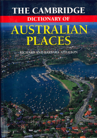
Book, The Cambridge dictionary of Australian Places, 1992
Lists thousands of place names across Australia, giving a detailed account of the name and location, shire etc.maps, pronunciation guidesgazetteer, nomenclature, maps, geography, pronunciation -
 Koorie Heritage Trust
Book, Department of Pacific and Southeast Asian History, Australian National University, Aboriginal History - Volume 08. 1-2 1984, 1984
This volume of 'Australian History' is devoted to studies of the south-eastern corner of the Australian continent. The papers arose from a series of meetings convened with Professer R. W. Dixon in 1981. They involved scholars from the disciplines listed, all concerned with the south-east. A series of articles by leading writers on Aboriginal History.237 P.; ill,; figs.; tables; notes; reviews; 24 cm.This volume of 'Australian History' is devoted to studies of the south-eastern corner of the Australian continent. The papers arose from a series of meetings convened with Professer R. W. Dixon in 1981. They involved scholars from the disciplines listed, all concerned with the south-east. A series of articles by leading writers on Aboriginal History.aboriginal australians -- periodicals. | ethnology -- australia -- periodicals. | settlement and contacts - colonisation - 1788-1850 | race relations - violent - massacres, murders, poisonings etc. - to 1900 | sex relations | indigenous knowledge - world view | language - personal names | language - semantics | social identity | language - sociolinguistics | government policy - state and territory - new south wales | socioeconomic conditions - living conditions | language - linguistics - language classification | language - vocabulary - word lists | language - linguistics | geography - territories and boundaries | art - rock art - painting | art - production - materials / techniques | art - art motifs | -
Unions Ballarat
Inside Australia and New Zealand, Gunther, John, 1972
Gunther was an American journalist and author. The "Inside" series of books are continental surveys. Gunther travelled through each geographical area, conducting interviews with a variety of people (politicians, average people, social leaders). The Inside series are his interpretations of these experiences. Relevant to Australian and New Zealand's cultural, political and social profiles circa 1972.Book; paper. Front cover: authors' name and title.ethnography, "inside" series, surveys, interviews, geography, politicians, social history, travel, btlc, ballarat trades hall, ballarat trades and labour council, anthropology -
Unions Ballarat
The tyranny of distance: how distance shaped Australia's history (Don Woodward), Blainey, Geoffrey, 1983
Australian history and how its distant location impacted upon this.History - Australia. Geography.Book; 365 pages. Cover: light grey background; picture of blue globe with a ship; black and red background; author's name and title.Glenn Howard 6C in blue biro.btlc, ballarat trades hall, ballarat trades and labour council, history - australia, geography - australia -
 Bendigo Historical Society Inc.
Book - Geographical dictionary
The Gazetteer presents an extensive a to z list of Victorian towns and villages, lakes, rivers and creeks, islands, bays, hills and mountains, runs and other localities and features. Entries include latitude and longitude, populations, proximity to other towns, local industries, coach and mail runs, hotels, churches and schools.Bailliere's Victorian Gazetteer and road guide containing the most recent and accurate information as to every place in the colony. Brown hardcover book, on the spine: Victorian Gazetteer with map 1865. The first and last pages are advertisements. The book has 442 pages listing every place in the colony. The map is not included. Compiled by Robert P. Whitworth. Published by Bailliere, Regent Street Unreadable name on first page and the name of F. Houston in blue pen on first page geographic dictionary, colony of victoria -
 Bendigo Historical Society Inc.
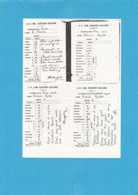
Document - GOLDEN SQUARE LAUREL STREET P.S. COLLECTION: EXAMINATION CARDS
Four white photocopy examination cards laminated upon blue cardboard and printed, SS 1189 , Golden Square, years 1941-42. Each outlines numbered marks out of ten for student named Elaine Rudd for subjects, Reading, Recitation, Spelling, Writing, Composition, English, Arithmetic A-B-C-D, History, Geography, Handwork, Art. B Rutherford and F Baggaley signatures. Written note states, 'Position; 3rd in class of 45. Excellent result. Elaine has done good work all the year. She seems to be very interested in her school work. Initialled FB.bendigo, institutions, golden square primary school -
 Bendigo Historical Society Inc.
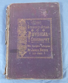
Book - Atlas of Physical Geography
The student's atlas of physical geography consisting of twenty maps, constructed and engraved by Edward Weller F.R.G.S. with descriptive letterpress by James Bryce L.L.D F.R.G.S. Published by William Collins, Sons & Company, London, Glasgow and Edinburgh 1871. Brown cover with the title of the book in gold letters. to the left of the title, also in gold, three circles with different pictures inside. the first of two boats on the sea, a volcanic eruption and a mountain peak.On first page in pencil the name Carrie Van Damme.geography, atlas, 1871 -
 Kew Historical Society Inc
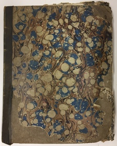
Album, Louisa G Thomas, Victorian Era Sketchbook, 1862
Louisa Thomas married Henry Gipps (1837-91)in 1863. They had six sons and two daughters. While Louisa and Henry Gipps were to die in Sussex, two of their sons, Frederick George De Visme Gipps (1867-1953) and Richard Brook Woodthorpe Gipps (c.1872-1946) migrated to Queensland, possibly bringing with them their mother’s sketchbook.The collection of artworks that are included in the sketchbook are often of outstanding aesthetic and artistic significance. In the variety of subject matter and the geographical places represented, it is historically significant as a document recording the postings of Colonel Henry Gipps, 9th Norfolk Regiment, and his wife Louisa to locations in the Mediterranean and West Asia. The large bound sketchbook has a marbled cover with blue binding. The name Louisa Goulburn Thomas and the date 1862 are faintly inscribed in pencil on the front page. However the book contains pen and ink and pencil drawings, watercolours, and photographs, which both predate and postdate 1862. The approximately 75 works are loose-leafed items and [currently] do not form a chronological, geographical or thematic sequence. Creators identified on some drawings and watercolours include Mary Julia Wilder Thomas, JFV Wright, ELG (Edward Louis de Bondell Gipps?), L Nicholson, Bertha Isadore Thomas, and HG (Henry Gipps?). Many of the works are signed and dated, and include rural landscapes and seascapes, archaeological sites, animal studies, and portraits. While most of the works were created in the British Isles, others are scenes of Venice, the Ionian Islands, Cape Town, Hong Kong and Japan. [A number of the ‘oriental’ paintings on silk were probably purchased from local artists.] The art works in the book are at various stages of completion and represent a diverse range of artistic skills. What may be the earliest work in the sketchbook is a drawing of three uniformed soldiers. An annotation on the reverse records that the drawing is of a Group of Soldiers after [Philipp Jakob] de Southerbourg 1830. The birth of Louisa Thomas' oldest son, William Henry Houston Meyrick Gipps (1864-1903) in Corfu perhaps explains why a number of scenes and items in the album are of the Ionian Islands. Louisa is probably the creator of a number of still life and botanical studies in the album. These range from floral studies to a bird’s nest. The painting of objects was to remain a socially ‘approved’ specialty of amateur and professional women artists into the 20th century. The complete contents of the album will be uploaded to accompany this record. Some items may be published separately on Victorian Collections, but will acknowledge their origins in the sketchbook."Louisa Goulburn Thomas / 1862"victorian sketchbooks, manuscripts - kew historical society, 9th norfolk regiment, rosemary (gipps) vaughan smith, vaughan-smith collection -
 Kew Historical Society Inc
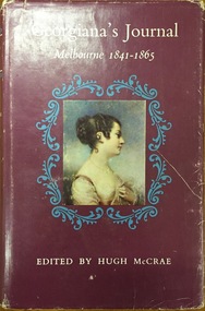
Book, Georgiana’s Journal: Melbourne 1841-1865, 1966
This diary tells the Australian story as it has never been told before and can never be told again. The journal consists mainly of entries in her diary made by Georgiana day by day as events took place. p.91; Brief mention of natives, fear of comet; p.100; Custom of exchanging names; plate facing p. 201 : portraits of Aboriginal people from Arthur's seat; p.204; Account of formation of Port Phillip Bay; p.213; Burial described; p.243; Words of songs of Goulburn blacks tribe; p.245; Description of a corroboree of men, and one of children; Place of women; p.247-253 is An Essay hostorical, geographical, anthropological and zoological taken from Georges Cahier dEcriture 1846; P.250; Description of the natives of New Holland - physical appearance, way of life, dances, shelters, food, weapons, method of stretching opossum skins; Vic. (S) - 6/9, 5/7, 5/5, 5/6, 4/7, 8/1.[Sydney] Angus and Robertson [1966] xxi, 262 p. illus., maps, ports. (part col.) 24 cm. non-fictionThis diary tells the Australian story as it has never been told before and can never be told again. The journal consists mainly of entries in her diary made by Georgiana day by day as events took place. p.91; Brief mention of natives, fear of comet; p.100; Custom of exchanging names; plate facing p. 201 : portraits of Aboriginal people from Arthur's seat; p.204; Account of formation of Port Phillip Bay; p.213; Burial described; p.243; Words of songs of Goulburn blacks tribe; p.245; Description of a corroboree of men, and one of children; Place of women; p.247-253 is An Essay hostorical, geographical, anthropological and zoological taken from Georges Cahier dEcriture 1846; P.250; Description of the natives of New Holland - physical appearance, way of life, dances, shelters, food, weapons, method of stretching opossum skins; Vic. (S) - 6/9, 5/7, 5/5, 5/6, 4/7, 8/1.mcrae, georgiana, georgiana mccrae, woman on victorian goldfields -
 8th/13th Victorian Mounted Rifles Regimental Collection
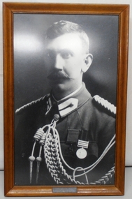
Photograph - Photograph Maygar, 1902 circa
Lieutenant Leslie Maygar served with the 5th Contingent Victorian Mounted Rifles in south Africa during the Boer War (1899-1902). He was awarded the Victoria cross for heroism . Maygar served with the 15th Light Horse (CMF) in the period 1902-1914 and at the outbreak of WWI (1914-1918) he was promoted to Major and appointed as a Squadron Commander with 4th Light Horse (AIF). He served at Gallipoli then was promoted Lieutenant Colonel and appointed Commanding Officer 8th Light Horse. He was serving in this capacity at Beersheba in October 1917 when the regiment was attacked by enemy aircraft. Maygar died of wounds sustained in the attack. Fine photograph of officer of the Victorian Mounted Rifles in the period immediately following the Boer War. Leslie Maygar was a native of the Euroa district and a geographic feature and a winery have been named in his honour.Framed black and white photograph of Lieutenant Leslie Maygar VC in Victorian Mounted Rifles uniform following his return from South Africa 1902. He is wearing his Victoria Cross and Queen's South African medal with three bars: Transvaal, Orange Free State, Cape Colony..Engraved panel at lower centre frame "Lt L C Maygar VC 5VMR / Date of Award 23-11.01"maygar leslie c lieutenant vc, victoria cross, vmr 5th contingent, 8th light horse regiment -
Surrey Hills Historical Society Collection
Programme - Ephemera, Chatham Primary School Fathers' Club 'Trial by Jury' programme, 16/11/1929
The program describes the performance as 'original burlesque' and was written, composed and produced by A E Woffinden and A W Sutton, members of the Chatham Fathers' Club, to raise money for the school. There were 250 programs printed at a cost of one pound fifteen shillings. This performance starred 21 of the fathers with Mr W Crellin as the only female character, Miss Eileen Flapper. The Chatham Fathers' Club became renowned locally for the quality of its performances, repeats being given to other community organisations. In the publication 'Chatham Past & Present: A Patchwork of People' there is also a photo of the cast taken in the quadrangle of the school. The original program and photo were lent to the school at the time of the 70 year reunion in 1997 by Mrs Jean Lacy (nee Walker), whose father took part as a member of the jury. Many of the performers were also in the formal photo of the Father's Club, taken in February 1928 on the front steps of the school. The original hangs in the school entry foyer and is reproduced in 'A Patchwork of People: Chatham Past and Present'. In relation to names, these are better identified and the following identifications have been reached by referencing this and the 1931 electoral roll. The geographic spread of addresses reflects that when Chatham opened in August 1927, surrounding schools were overcrowded and some families chose to relocate their children. Albert Ernest Woffinden (manufacturer) lived at 14 Banool Road, Surrey Hills. Alfred William Sutton (clerk) lived at 528 Whitehorse Road, Surrey Hills. Mr A Davidson - not found in electoral roll. Walter Dallas Kinross (mechanic) lived at 72 Empress Road, Surrey Hills. Gilbert Leslie (Bert) Rae (sales) lived at 63 Empress Road, Surrey Hills. Mr Joseph P Braddick (mechanic) lived at 1 Northcote Avenue, Canterbury; now Balwyn (NB/ Name is miss-spelt Braddock in the program). Norman Patrick Smart (bt opr) lived at 61 Sir Garnet Road, Surrey Hills. Henry Albert Wysham (show card writer) lived at 9 Northcote Avenue, Canterbury. Mr Sidney Bessant (labourer) lived at 191 Mont Albert Road, Canterbury. William Morrison (teacher) lived at 37 Chatham Road, Canterbury. William Charles Crellin (breadcarter) lived at 59 Empress Road, Surrey Hills. Mr F Parsons - taken as Fred Parsons (bricklayer) lived at 2 Kaarumba Grove, Balwyn. Mr MacDougal (incorrectly spelt in program) is Dougall MacDougall (gas collector) lived at 5 Wells Street, Surrey Hills. Mr A V Webb - not found. Mr McKie - not found. Victor Harold Theodore Clow (civil servant) lived at 4 Talbot Avenue, Balwyn; listed as T. Clow. Mr M Walker (donor's father) not found in electoral roll for 1931; thought to have lived in Sir Garnet Road. Mr McLeod - a number listed in the 1931 electoral roll. Richard Frost (carriage builder) lived at 341 Mont Albert Road, Surrey Hills. Mr Allen - a number listed in the 1931 electoral roll. Mr J Tulloch - not found in the 1931 electoral roll. This is an example of 'home-spun' entertainment and creativity of the era when the sense of community was very real. It is an example of the fundraising efforts undertaken by school communities to provide 'extras' that would later be regarded as 'basics'. For many years the sense of community in this part of Surrey Hills revolved around Chatham school, the Benson Street Methodist Church and the football club, located at the Canterbury Recreation Ground.A photocopy of the programme for the Chatham Primary School Fathers' Club "Trial by Jury" performance on 16 November 1929. It includes the words of the song 'Carry me back to dear old Chatham'. It lists the performers by character and some details regarding the Chatham Primary School Fathers' Club.chatham primary school, chatham primary school fathers' club, theatrical productions, entertainment, albert ernest woffinden, fundraising, alfred william sutton, walter dallas kinross, gilbert leslie (bert) rae, joseph p braddick, norman patrick smart, henry albert wysham, sidney bessant, william morrison, william charles crellin, fred parsons, dougall macdougall, mr a v webb, mr mckie, victor harold theodore clow, mr m walker, mr mcleod, richard frost, mr allen, mr j tulloch -
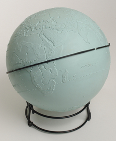 Vision Australia
Model - Object, Tactile globe, 1950-1965 approx
Used to teach geographical information, this tactile globe was most likely produced by the RNIB and used at the RVIB Burwood School. Equator is raised and marked in black rubber. Topography land masses and meridians are tactically represented, and includes place names in Braille. A different shade of green is used to represent land masses, and major rivers are shown as well.Green plastic tactile globe with metal stand.Variouseducation aids and devices, rvib burwood school -
 Federation University Art Collection
Painting - Artwork - Painting, Lord Krishna marrying Radha (Madhubani Art), c2014
Madhubani art or Mithila painting was traditionally created by the women of various communities in Mithila region of the Indian subcontinent. It originated from Madhubani district of Mithila region of Bihar, and, it is popularly called Mithila painting or Madhubani art. Madhubani is also a major export centre of these paintings. This painting as a form of wall art was practiced widely throughout the region; the more recent development of painting on paper and canvas mainly originated among the villages around Madhubani, and it is these latter developments led to the name Madhubani art being used alongside the name "Mithila Painting." The painting was traditionally done on freshly plastered mud walls and floors of huts, but now they are also done on cloth, handmade paper and canvas.[3] Madhubani paintings are made from the paste of powdered rice. Madhubani painting has remained confined to a compact geographical area and the skills have been passed on through centuries, the content and the style have largely remained the same. Madhubani paintings also use two-dimensional imagery, and the colors used are derived from plants. Ochre and lampblack are also used for reddish brown and black respectively. Generally, no space is left empty; the gaps are filled by paintings of flowers, animals, birds, and even geometric designs.(wikipedia)Framed traditional Hindu story painted onto textile.madhubani, indian, krishna, radha, punjab, mehndi -
 Kilmore Historical Society
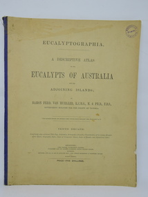
Book, Baron Ferdinand von Mueller et al, EUCALYPTOGRAPHIA. Tenth Decade, 1884
A descriptive atlas of the Eucalypts of Australia and adjoining islands. This last part of the series also contains a Synopsis of the Species, Geographic Index, Index of Vernacular Names, Index of Decades and Alphabetical Index.Light card cover with blue cloth backstrip to spine, torn at upper extremity. Some staining and marks on cover, discoloration from light exposure. Some foxing through out. Binding intact. Fair condition.non-fictionA descriptive atlas of the Eucalypts of Australia and adjoining islands. This last part of the series also contains a Synopsis of the Species, Geographic Index, Index of Vernacular Names, Index of Decades and Alphabetical Index.botany, eucalypts, australia -
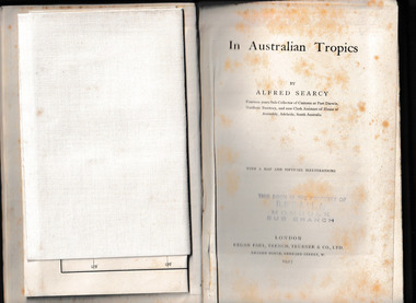 Mrs Aeneas Gunn Memorial Library
Book, Kegan Paul Trench Trubner and Co, In Australian tropics, 1907
Early history of N.T. and explorations; Detailed account of intercepting Macassan proas around coast of Arnhem Land whilst author was Sub-Collector of Customs for 14 years; Names of proas and masters, Malay camps & smoke houses along coast & nearby islands; Natives employed by Malays in trepang fishing and collecting tortoiseshell, relationships between Malays and Aborigines; influences (physical & cultural); Habit of exchanging children between tribes (Roper R. & Normanton) for the purpose of learning each others language & customs; Description of native camps at Fort Dundas (1895) shelters, finding of bark water bags, types of canoes used; Platform burial at Daly R.; Sacred burial site on Maria Island; Geographical features, vegetation, climate etc., general ecology, depredations & murders by natives; Cannibalism practiced by Fitzmaurice River tribes.Ill, maps, p.373.non-fictionEarly history of N.T. and explorations; Detailed account of intercepting Macassan proas around coast of Arnhem Land whilst author was Sub-Collector of Customs for 14 years; Names of proas and masters, Malay camps & smoke houses along coast & nearby islands; Natives employed by Malays in trepang fishing and collecting tortoiseshell, relationships between Malays and Aborigines; influences (physical & cultural); Habit of exchanging children between tribes (Roper R. & Normanton) for the purpose of learning each others language & customs; Description of native camps at Fort Dundas (1895) shelters, finding of bark water bags, types of canoes used; Platform burial at Daly R.; Sacred burial site on Maria Island; Geographical features, vegetation, climate etc., general ecology, depredations & murders by natives; Cannibalism practiced by Fitzmaurice River tribes. northern australia - description and travel, ethnography -
 Eltham District Historical Society Inc
Photograph - Digital Photograph, Alan King, Panton Hill Hotel, 27 March 2008
Today’s Panton Hill Hotel was built around 1920. Published: Nillumbik Now and Then / Marguerite Marshall 2008; photographs Alan King with Marguerite Marshall.; p61 Panton Hill was originally known as Kingstown, and consisted of only one hotel when the Orams Reef was discovered in 1859. Kingstown was a quartz mining centre and many old mine shafts remain in the area. Orams Reef was one of the first reefs with a rich find of gold in the area. The Hotel Francais, which had been operating in 1861, was well situated on the way to Queenstown (later St Andrews). So was Herr Hirt’s Hotel and store at Smiths Gully. The Kingstown hotel, known as the Frenchman’s and in 1864 as the Hotel de France, was run by a Monsieur Emile Hude and his wife Jeanne, and known for its good food. They hosted social events, business conventions and debates, attracting patrons from as far as Melbourne. The hotel’s name was changed to Panton Hill Hotel in 1905. In 1883 Charles Caudwell built another hotel nearby, possibly in Long Gully Road,3 which it is thought, was burnt down early last century. Today’s Panton Hill Hotel, built around 1920, is the only one of the cluster of buildings in the main road, not to date from around the turn of last century. It was severely damaged by fire in 2003, then underwent extensive alterations. It is the township’s only hotel and is an example of a modest hotel building exterior, constructed early last century. In its early days the hotel also housed the first post office, newsagency and store. Orams Reef yielded a total of £100,000, and fossikers also found alluvial gold in the creeks and gullies, but there is no record of the total value of their finds. Gold greatly increased the Panton Hill population, which peaked between 1865 and 1885. On holidays large sports meetings were held with wood chopping contests and foot races and the day would end with a ball. Miners came from various countries to seek their fortune, including many from China. The Chinese became unpopular however, and gradually left the district, although some stayed and grew and sold vegetables.5 Panton Hill was named after Joseph Panton, who in 1862 was appointed Police Magistrate for the Woods Point, Heidelberg and Yarra districts. Panton was an outstanding man, who in 1852, was Commissioner of Crown Lands and Assistant Commissioner of Goldfields at Bendigo. In 1874 he was promoted to Chief Magistrate for the Melbourne Police. Panton was also an artist, becoming president of the Victorian Arts Society in 1888, and in 1913, president of the Royal Geographical Society. Despite Panton Hill’s prosperity, it still lacked many services as poor roads made access to Melbourne difficult. A horse-drawn mail coach travelled to Melbourne until 1890, when the railway came to Heidelberg. The nearest doctor was at Yarra Glen or Heidelberg, and the Indian hawker Singh’s annual visit was very welcome. A miner’s shack opposite the school was used as a post office. Today’s general store and post office in the main road dates from early last century, and has changed considerably. While most people searched for gold, the more enterprising ones established farms to feed the diggers. Farmers grew wheat, barley and oats, and sent animal skins to the Eltham tannery, to make furs in Melbourne. As gold became scarce from around 1880, miners took up farming on 19 to 20 acre (8ha) allotments. The first settlers in Cherry Tree Road included Purcell, Smith, Owens, Hughes and Shillinglaw. By 1900 all the land had been taken up around Panton Hill and Hurstbridge. The orchards in Panton Hill and the wider district, particularly of apple and pear, were very successful, and made Panton Hill a cohesive and successful community. About 1914 the Moores built the first cool-store and refrigeration plant at their orchard in Cherry Tree Road. Many settlers planted vineyards and made high quality wine, but in 1922 the blight destroyed them.This collection of almost 130 photos about places and people within the Shire of Nillumbik, an urban and rural municipality in Melbourne's north, contributes to an understanding of the history of the Shire. Published in 2008 immediately prior to the Black Saturday bushfires of February 7, 2009, it documents sites that were impacted, and in some cases destroyed by the fires. It includes photographs taken especially for the publication, creating a unique time capsule representing the Shire in the early 21st century. It remains the most recent comprehenesive publication devoted to the Shire's history connecting local residents to the past. nillumbik now and then (marshall-king) collection, panton hill hotel -
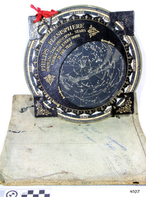 Flagstaff Hill Maritime Museum and Village
Planisphere, Early 20th Century
The word Planisphere (Latin planisphaerium) was originally used in the second century by Claudius Ptolemy to describe the representation of a spherical Earth by a map drawn in the plane. This usage continued into the Renaissance: for example Gerardus Mercator described his 1569 world map as a Planisphere. The word describes the representation of the star-filled celestial sphere on the plane. The first star chart to have the name "Planisphere" was made in 1624 by Jacob Bartsch. Bartsch was the son-in-law of Johannes Kepler, discoverer of Kepler's laws of planetary motion. A significant item of celestial mapping used by marine navigators This particular item was made and used in the first quarter to half of the 20th centuryPlanisphere of northern hemisphere, with canvas bag. Planisphere consists of a circular star chart attached at its centre to an opaque circular overlay that has a clear elliptical window or hole so that only a portion of the sky map will be visible in the window or hole area at any given time. The chart and overlay are mounted so that they are free to rotate about a common pivot point at their centres. The star chart contains the brightest stars, constellations and (possibly) deep-sky objects visible from a particular latitude on Earth. The night sky that one sees from the Earth depends on whether the observer is in the northern or southern hemispheres and the latitude. A Planisphere window is designed for a particular latitude and will be accurate enough for a certain band either side of that. Planisphere makers will usually offer them in a number of versions for different latitudes. Planispheres only show the stars visible from the observer's latitude; stars below the horizon are not included. A complete twenty-four-hour time cycle is marked on the rim of the overlay. A full twelve months of calendar dates are marked on the rim of the starchart. The window is marked to show the direction of the eastern and western horizons. The disc and overlay are adjusted so that the observer's local time of day on the overlay corresponds to that day's date on the star chart disc. The portion of the star chart visible in the window then represents (with a distortion because it is a flat surface representing a spherical volume) the distribution of stars in the sky at that moment for the Planispheres designed location. Users hold the Planisphere above their head with the eastern and western horizons correctly aligned to match the chart to actual star positions. "Made in Germany for GEORGE PHILIP & SONS Ltd. Geographical and Educational Depot, 32 Fleet Street, London" Canvas bag has "Capt. H (Howard) Tyler from Captain H. F. Woolf" "Tyler 22 ? St East Brighton" also "13 Halls St Flinders"flagstaff hill, warrnambool, shipwrecked-coast, flagstaff-hill, flagstaff-hill-maritime-museum, maritime-museum, shipwreck-coast, flagstaff-hill-maritime-village, planisphere, star map, marine navigation, maps, george philip & sons -
 Flagstaff Hill Maritime Museum and Village
Book - Textbook, Introduction to Modern Geography
This mid-19th century scientific reference book, Introduction to Modern Geography, explains geography and astronomy using the globe of the world as a teaching aid. The inscription connects this book to the Bobinawarrah Public Library but research to date has found no further details about the library. The rural area was settled in 1859, but in 2016 its population was only 87. It is situated about 21 kilometres south of the City of Wangaratta, in Northeast Victoria. In 2024 the local community received a grant for preservation of its almost 100-year-old Bobinawarrah Memorial Hall which displays an honour board of the Pioneers of Bobinawarrah 1859-1959. The donor of the book lived in Warrnambool. ABOUT THE AUTHOR, James Thomson (1786-1849): - James Thomson was a British Irish mathematician. He became Professor of Mathematics at the University of Glasgow. He wrote many school textbooks and reference books, one of which was Introduction to Modern Geography, first published in Belfast in 1827, and revised and published in over 20 more editions. Thomson tutored two of his several children at home. His older son James Thomson (1822-1892) became an engineer and physicist. His younger son William Thomson (1824-1907) became Professor of Natural Philosophy from 1846-1899 at the University of Glasgow, and later the 1st Baron of Kelvin, famous for his designs of nautical instruments such as the navigational compass and sounding equipment used in the transatlantic installation of sea cable. William was part of the firm that became famous as Kelvin & Hughes Ltd., suppliers of radar and echo sounders to the Ministry of Transport and the Ministry of Defence. The name continued on as Kelvin & Hughes. James Thomson (1786-1849) was a renowned British Irish mathematician and Professor of Mathematics at the University of Glasgow. He was a respected author of many important school books and textbooks that were widely used to provide understanding of arithmetic and geography. Thomson encouraged practical education and held extra classes for young ladies to learn mathematics and geography, which were a novelty at that time. Many of his works were known and used worldwide. This work was published in many editions. It is now considered as culturally significant as a basis for knowledge about our civilisation and has been made publicly available in overseas countries, and republished and reproduced in a readable format, including its diagrams and maps. Book; scientific textbook. The book has a black leather cover. The front cover is blank, but the spine has an embossed gold vertical title within a rectangular border boasting fancy corners. The fly page has a detailed title. The author is James Thomson. It is the Eighteenth edition, published in Simms & McIntyre of London and Belfast in 1845. An inscription connects it to the Bobinawarrah Public Library in Victoria.Spine within a gold border: "THOMSON'S GEOGRAPHY" Fly Page: "AN INTRODUCTION TO MODERN GEOGRAPHY, WITH AN APPENDIX, CONTAINING AN OUTLINE OF ASTRONOMY, AND THE USE OF THE GLOBES. BY JAMES THOMSON, LL.D., PROFESSOR OF MATHEMATICS IN THE UNIVERSITY OF GLASGOW." "Eighteenth Edition" "LONDON: SIMMS AND McINTYRE, ALDINE CHAMBERS, PATERSOSTER ROW; AND DONEGALL -STREET, BELFAST.""1845"flagstaff hill, flagstaff hill maritime museum and village, warrnambool, maritime museum, maritime village, great ocean road, shipwreck coast, introduction to geography, james thomson, reference book, professor thomson's introduction to modern geography, bobinawarrah public library, james thomson mathematician, james thomson engineer, 19th century irish mathematician, irish presbyterian, william thomson 1st baron of kelvin, professor of mathematics, glasgow university, william thomson professor of natural philosophy, introduction to modern geography, outline of astronomy, use of the globes, james thomson ll.d., simms and mcintyre, 1843, scientific book, school book, lord kelvin, baron kelvin of langs, nautical instruments, marine instruments, transatlantic cable, kelvin & hughes, thomson’s geography, astronomy, geography, world globe, cartography, pioneers of bobinawarrah, textbook