Showing 57 items
matching gippsland highway
-
 Orbost & District Historical Society
black and white photographs, second half 20th century
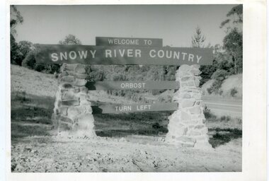
These photographs are pictorial records of the signs at the Orbost town entry points.Three black / white photographs. 3277.1 is a sign on stone pillars at the top of a hill - "WELCOME TO SNOWY RIVER COUNTRY ORBOST TURN LEFT". 3277.2 shows a road leading into a town. There is a sign on the left - "ORBOST" and a service station on the right. 3277.3 shows a row of newly planted trees between a road and a school.3277.1 on back - "WELCOME TO SNOWY RIVER COUNTRY - ORBOST sign - Princes Highway - Newmerella" 3277.2 on back - "East Gippsland Shire Sign on eastern approach to ORBOST., in Salisbury Street, near Orbost Secondary College" 3277.3 on back - "Tree planting in Salisbury St, Orbost in front of Orbost High School looking west towards Orbost township"photographs-orbost orbost-township-entry salisbury-street-trees town-entry road-signs-orbost -
 Orbost & District Historical Society
Container - Plastic bag/container, plastic bag SNOWY RIVER CO-OP
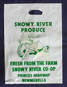
A plastic produce bag from c.1990s used for promotion of the SNOWY RIVER PRODUCE Co. which was famous as a sweet corn producer. The sweet corn was grown locally under contract by farmers in the Orbost district and marketed through the Co. This company no-longer exists (2022).a rare item to survive as evidence of the Snowy River Produce CoA white plastic bag, printed on both sides with green print. One side has a drawing of a bucking horse and rider, and the other side a piece of yellow coloured corn. The bag has a hand hold opening. Size of bag: H-504mm W-362mmSide 1: SNOWY RIVER PRODUCE. FRESH FROM THE FARM SNOWY RIVER CO-OP PRINCES HIGHWAY MEWMERELLA Side 2: SNOWY RIVER CO-OP FAMOUS FOR SWEET CORN PRINCES HIGHWAY NEWMERELLA phone (051) 541878orbost, sweet corn, farming produce, snowy river produce co. -
 Orbost & District Historical Society
Functional object - Bell, hand-held, Early 20th century, c.1900s
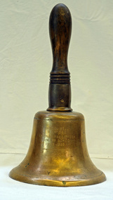
The settlement of Cabbage Tree Creek is located on the Princes Highway, 27 km east of Orbost in East Gippsland. The creek, which flows through undulating forest, takes its name from the patches of Cabbage Fan palms growing along its course. A school commenced classes in 1913, but enrolment was small and at times the school operated part time with several other small schools in the area. The school building served as a hall for the district. About 1946 two sawmills commenced operations at Cabbage Tree Creek, and the Forests Commission ranger was stationed in the area. The increased population allowed the school to have more teachers and make improvements. In 1953, a new prefabricated building was erected on a new site. However, by the 1970s employment in the timber industry was unstable and the population decreased. By 1974 the school again had only one teacher and eventually closed in 1993 to amalgamate with the Orbost primary School in Ruskin Street, Orbost. (Ref. VictorianPlaces)The school bell is a signal that tells a school's students when it is time to go to class in the morning and when it is time to change classes during the day as well as when students are dismissed from school. In most schools today it will be a tone, siren, electronic bell sound, a series of chimes, or music played over an intercom but often still called "the school bell". This item reflects the history of Cabbage Tree Creek as well as the technological changes in the school system.Brass bell with incised double lines on bottom edge and top near handle, featuring descriptive notation on front face. Bell has long wooden handle shaped and incised with four lines at base before brass housing with singular screw holding handle in place. Object is showing signs of wear, with blackened handle and patches of green oxidisation.SCHOOL BELL / SS No 3812 / CABBAGE TREE CREEK / PRIMARY SCHOOL / 1913-1993 / FORMALLY INCORPORATED / INTO / ORBOST / PRIMARY SCHOOL / 1994cabbage tree, east gippsland, cabbage tree creek, cabbage tree creek primary school, orbost primary school, school bells -
 Orbost & District Historical Society
framed certificate, January 2003
This certificate was presented at the East Gippsland Shire Council Australia Day celebrations on 26.1.2003. The veiling of McKillops bridge was a 'Year of the Outback' event. The event was organised by Orbost resident, Sr Helen Barnes RSJ. to show solidarity with rural people. The local community transformed the bridge into "a symbol of communal love and hope", when its sides were draped with hundreds of personal messages. McKillop's Bridge, located high in the Snowy Mountains, is named after George McKillop, a pioneering explorer of the area. The bridge is a vital link for isolated farming communities living beyond the Bonang highway. The Veiling of McKillops Bridge was a significant community event.A large framed certificate. An Australia Day Community Event certificate for January 2003. The frame is silver The certificate has white, green and blue print on a blue background.presented to "Veiling of McKillops Bridge on frame corner AMS by East Gippsland Shie Council signed by Cr P. Bommer (mayor)mckillops-bridge-veiling east-gippsland-shire-council-australia-day -
 Orbost & District Historical Society
book, Vic Roads Centenary 1913 -2013, 2013
The publication, VicRoads Centenary: Keeping Victorians Connected for 100 Years, looks at the people and projects that define VicRoads’ history. Written by current and former VicRoads’ employees, the publication details the organisation’s portfolio of major projects, which includes the Great Ocean Road, Hume Highway and Eastern Freeway. Other sections report on Victoria’s world-first road safety initiatives, VicRoads’ use of technology and sustainability measures. (ref VicRoads) This item is one of several books donated by David Jellie at a presentation to Orbost Historical Society. He was a contributor to the book and was the engineer for the Snowy River Bridge (Princes Highway) at Orbost 1974-1976.This book is a useful reference tool on the history of road construction in Victoria including East Gippsland.A thick, bound paperback book, titled "VicRoads Centenary Keeping Victorians Connected for 100 Years". On the front cover is a black/white photograph of two men working on a road. One has a pick. The book contains the history of VicRoads, photographs, maps and advertisements. Some are b/w. Others are coloured.vicroads book roads snowy-river-bridge jellie-david -
 Australian National Surfing Museum
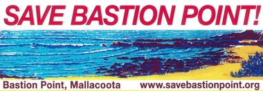
Sticker, SAVE BASTION POINT, Circa 2010
This colour sticker was produced and distributed Australia wide by the SAVE BASTION POINT CAMPAIGN to support their environmental campaign to stop a breakwall being built across the popular surf break - Bastion Point in Mallacoota, Victoria, Australia. The breakwall is supported by the local fishing community and local council. If built it would destroy one of the most popular surf breaks in East Gippsland.This sticker represents a local environmental campaign which has gained state and national attention. Full colour gloss car sticker featuring graphic artwork of Bastion Point and the website for the SAVE BASTION POINT campaign (based in Mallacoota, Victoria, Australia)Web address - www.savebastionpoint.orgsurf, bastion point, mallacoota, breakwall, surfrider foundation, east gippsland, save bastion point -
 Federation University Historical Collection
Document - Reports, Large Cats, Thylacenes and Large Predators Sigtings, 1975-1985 and 2002-2011
The folder of correspondence is the result of a Freedom of Information request made to the Department of Sustainability and Environment in 2011. The folder was collected for research being conducted by David Waldron.Folder of correspondence and newsclips relating to "Big Cats" and other large predators. Please note: sections of this file are closed to protect the privacy of correspondents.australian mythical animals collection, david waldron, brian waters, moonambel, joyce collins, ian smith, thylacene, marrarkuli, burragorang, m.g. hornocker, mt bepcha, billywing upland, john a. henry, bryan wlaters, ken bodinnar, harcourt, kevin farley, fowlers bay, carolyn hodges, puma, macarthur, paynesville, john aldreson, animal damage control, mountain lion, bryan walters, cougar, big cat, maryborough, joan kirner, bernard mace, tasmanian tigers, d.g. willey, calder highway sightings, kevin phelen, mt richmond national park, feral cat, felis catus, lancefield, pyalong, broadford, pyalong pantherleopard, porsche park, dick shaw, big cats in victoria, peter hall, lyn sellens, south gippsland, plaster cast, foot cast, unidentified wildlife, john seeback, michael moss, carnivores, halls gap, halls gap puma scats, kooreh, ballan, ballan large cat, a.g. kerr, south gippsland tasmanian tiger sightings, central victorian puma, otways, wilsons promontory, john higgins, tasmanian wolf, j.k. depmster, vermin, lion, cooper's creek, warrego river, dingo, thylacinus cynocephalus, mirboo north, newham, operation puma victoria, australian skeptics, kangaroo ground, rare fauna, black wildcat, pyalong panther, bob warneke, black puma, maryborough puma, creswick panther, cape bridgewater, pyrenees panther, footprints, daisy hill, bung bong, phantom puma, geranium springs, maurice hornocker -
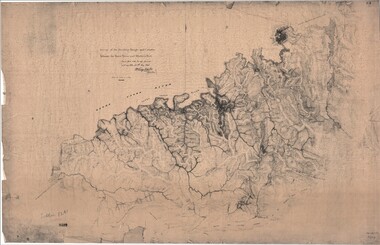 Ringwood and District Historical Society
Map, Survey of Dividing Range between Yarra Yarra and Western Port - William Wedge Darke, 1843
Extract - Ringwood, Place of Many Eagles - Hugh Anderson (1974): William Wedge Darke, from Hereford, England, was a nephew of John Helder Wedge of the Port Phillip Association, who was also a surveyor. William's most important work was probably his survey of the Dividing Range and the country between the Yarra River and Western Port, completed in May 1843, and during which he made a traverse between the Mullum and Dandenong creeks along the higher ground that he labelled the "best line of road from Melbourne". This road was for many years the major route to Gippsland and to the higher country about Alexandra and Mansfield, sometimes known as White Horse Road, and now Maroondah Highway.Surveyor's relief map of features to the east of Melbourne including Yarra Yarra River, Mullum Mullum Creek, Anderson's Creek, Dandenong Creek.Transmitted to the Surveyor General with my letter of 10th May 1843 (signed) Wm Wedge Drake, Assistant Surveyor. Scale: two inches to a mile. Descriptive remarks include upstream area of Yarra River - "impassable, appears to have been formerly a lake", and to the south - "barren and scrubby swamps of the Western Port Country". Marked tracks include "best line of road from Melbourne", "track to Dandenong", "Road to Port Albert may probably be found on this range", "Best line to Upper Yarra". Several huts also marked. -
 City of Moorabbin Historical Society (Operating the Box Cottage Museum)
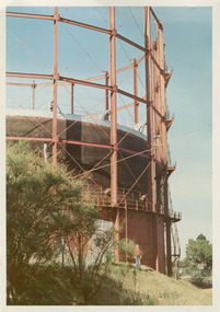
Photographs, x3 Colour,, Highett Gasworks c1974, 1974
3 of 5 photographs of the Highett Gasworks c 1974 The Brighton Gas Company was established 1877 by local residents including Thomas Bent. Initially all went well for residents as gas light replaced kerosene lamps and street lights were installed. However disruption to supply, poor quality and failure to reach all house lead to dissatisfaction. Thomas Bent therefore began the Central Brighton and Moorabbin Gas Company 1885 and a price war ensued. This was unsustainable and the two companies amalgamated in 1877 supplying gas from the New Street Works site. 1930 this Company expanded to Highett where it had purchased 45 acres adjacent to the train line. 1927 a gas holder was built connected to the Brighton works 1936 construction began on a complete gas-making unit and the Highett Gasworks, Nepean Highway, began supply 1939. 1950 an extension program was completed. However by 1965 , with the discovery of Natural Gas offshore in Bass Strait, changes to Gas distribution were apparent. At first some of the facilities at Highett were used to distribute the gas piped from Sale, Gippsland. However after conversion of 450,000 homes to Natural Gas the Highett site was redundant. The gasometers were removed 1978. Moorabbin Council obtained part of the land for public recreation purposes. ( Dr. G Whitehead KCC Historian ) c2012 the Moorabbin Justice Centre / Magistrates Court of Victoria was built and further development of the area for apartments proceeds. The establishment of the Brighton Gas Company 1877 and the Highett Gasworks 1885 brought bright lighting to houses, businesses and streets in Moorabbin Shire and cooking ovens and heating improved the living conditions of residents. 3 x Colour photographs of the Highett Gasworks c1970bass strait gas, highett gasworks, brighton gasworks 1877, central brighton and moorabbin gas company 1885, whitehead dr. graham, magistrates court of victoria, horse drawn carts, toll gates brighton, motor cars 1900, steam engines, early settlers, bentleigh, parish of moorabbin, city of moorabbin, county of bourke, moorabbin roads board, shire of moorabbin, henry dendy's special survey 1841, were j.b.; bent thomas, o'shannassy john, king richard, charman stephen, highett william, ormond francis, maynard dennis, market gardeners, vineyards, orchards -
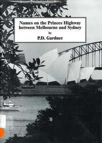 Victorian Aboriginal Corporation for Languages
Book, P D Gardner, Names on the Princes Highway between Melbourne and Sydney : their origins, meanings and history, 2000
Place name list in a specific area. Giving descriptions and meanings.Maps, b&w illustrationsdandenong, genoa, south coast nsw, yarra river, moruya, kiama, captain cook, east gippsland, rosedale -
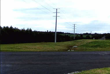 Inverloch Historical Society
000894 - Photograph - 1997 - Inverloch - corner of highway and Cashin St - line of old road - from K Howsam (Ken)
-
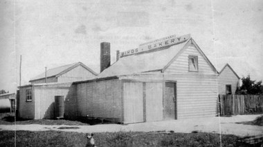 Grantville History Group U3A
Photograph, Grantville - Birds Bakery
The Bird family built and conducted the bakery on the highway at grantville diagonally opposite the General Store, circa 1930s. Ron Tilley married eldest daughter, Gloria Bird (Tops) in 1945.grantville; business; bakery -
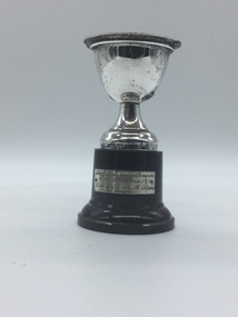 Trafalgar & District Historical Society
Trophy, Marquis, 1974
... Trafalgar & District Historical Society Princes Highway ...Silver cup on black baseTrafalgar Young Farmers Bike A. Canna 1974. Best Girl Rider. M. Adams. -
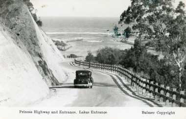
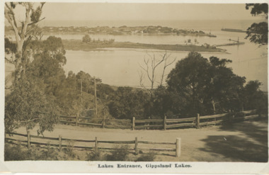
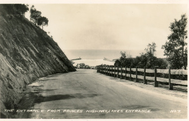 Lakes Entrance Historical Society
Postcard - Princes Highway Lakes Entrance, Valentine Series, 1940c
Black and white small format postcard of the Princes Highway at Kalimna Hill The road winds between the steep road cutting and a post & rail guard fence. In the distance is the artificial entrance to the Gippsland Lakes. Lakes Entrance VictoriaThe entrance from Princes Highway, Lakes Entranceroads and streets, fences -
Port Melbourne Historical & Preservation Society
Photograph - Shipping using Webb Dock, Williamstown and various River Yarra berths, Ron Laing, 1986 - 1999
A set of 83 photographs of shipping using Webb Dock, Williamstown, various river berths and movements in the Yarra River 1986-1999mairangi bay, columbus australia, michigan highway, anro australia, toyofuji 8, columbus america, union rotoma, searoad tamar, antwerpen, contship jork, queensland star, kha bhum, columbus new zealand, city of port melbourne, dock express ii, direct kea, samas spirit, arafura, contship action, searoad mersey, ville de capella, australia bridge, juthia bhum, direct eagle, columbia star, torrons, hakuyou maru, berlin express, tourcoing, rabelis, bass trader, zim brisbane, australian advance, sea venus, morning light, matilda bay, ooclexporter, qiutte, lloydiana, direct kookaburra, nichigon maru, era, golden crux ii, canopus, stolt sincerity, ionikos, iron gippsland, ehjin, satucket, irene, paum monarch, torbon spirit, cgm, la perouse, amvella, transport - shipping, piers and wharves, ron laing, eclipse -
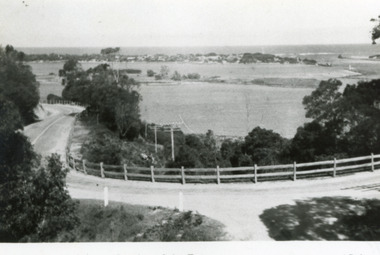
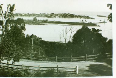 Lakes Entrance Historical Society
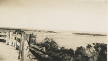
Photograph - The Entrance, 1930 c
Black and white photograph of the Princes Highway at Jemmys Point, showing post and rail fence beside road, Bullock Island, the houses of Carpenter town on the southern shore of Cunninghame Arm and Entrance. Lakes Entrance VictoriaLakes Entrance- Gippsland Lakes'coast, fences, roads and streets -
 Lakes Entrance Historical Society
Postcard - The Entrance, Bulmer H D, 1930c
Black and copy 9 x 13.5, has inscription 'Princes Highway and Entrance, Lakes Entrance', ink spill on photo top right hand areaTinted small format postcard of the Princes Highway winding around Jemmys Point, between the steep road cutting and post and rail fence, entrance to Gippsland Lakes in the distance. Lakes Entrance Victoria waterways, roads and streets, vehicles -
 Lakes Entrance Historical Society
Postcard, Bulmer H D, 1950c
Also one other postcard same donated by M & V Carpenter in spares box.Black and white postcard of the Princes Highway Jemmys Point, showing Bullock Island between North Arm and Cunninghame Arm, distant view of the entrance from Bass Strait to the Gippsland Lakes. Post and rail fence along roadside. Lakes Entrance VictoriaPrinces Highway and a view of the Entrance vegetation, roads and streets -
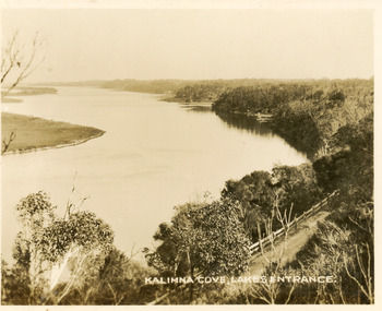 Lakes Entrance Historical Society
Postcard - Reeves Channel, Valentine Series, 1930c
Black and white small format postcard of Reeves Channel Gippsland Lakes, taken from Jemmys Point. It shows a glimpse of the Princes Highway, the steep shoreline of the mainland opposite Rigby Island with Fraser Island and Flannagan Island in distance. Lakes Entrance VictoriaKalimna Cove Lakes Entranceislands, waterways, topography -
Lakes Entrance Historical Society
Book, Synan Peter, Highways of Water- How shipping on the Lakes shaped Gippsland, 1989
A history of the Gippsland Lakes Victoria as a transport system for trade with in the lakes and river systems, and coastal and interstate tradeships and shipping, land settlement, waterways -
 Lakes Entrance Historical Society
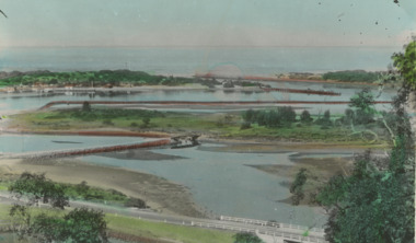
Photograph - Lakes Entrance, Gippsland Ports, 2006 c
Second copyColour aerial photograph of entrance from Bass Strait to Gippsland Lakes including Bullock Island Reeves Channel Rigby Island houses on Kalimna Hill and Princes Highway winding down Jemmys Point hill into township of Lakes Entrance Victoriaaerial photograph, ocean, waterways -
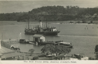 Lakes Entrance Historical Society
Postcard - SS Wyrallah, H D Bulmer, 1930 c
Black and white postcard showing SS Wyrallah passing the New Works jetty outwards from wharf. Princes Highway and Jemmys Point in distance, Lakes Entrance VictoriaThe New Works Jetty showing Jemmys Pointships and shipping, transport, gippsland lakes, jetties -
 Lakes Entrance Historical Society
Photograph - The Entrance Lakes Entrance, 1925 c
The entrance to Gippsland Lakes taken from Princes Highway, post and rail fence in foreground Lakes Entrance VictoriaBlack and white photograph of entrance taken from Princes Highway, post and rail fence in foreground Lakes Entrance Victoriaboats and boating, islands, waterways, gippsland lakes -
 Lakes Entrance Historical Society
Postcard - Bullock Island Lakes Entrance, H D Bulmer, 1950 c
Bullock Island and first traffic bridge. Bullock Island has no development. North Arm bridge and Princes Highway in foreground, New Works area across Cunninghame Arm in distance Lakes Entrance Victoria. Also a cut down colour photograph of second humpy bridge to Bullock Island donated by M Fish number 04208.1 size 3 x 13 cm|Also two black and white photographs numbers 04208.2 and 04208.3 in SparesColour tinted postcard of Bullock Island and first traffic bridge. Bullock Island has no development. North Arm bridge and Princes Highway in foreground, New Works area across Cunninghame Arm in distance Lakes Entrance Victoria. Also a cut down colour photograph of second humpy bridge to Bullock Island donated by M Fish number 04208.1 size 3 x 13 cm|Also two black and white photographs numbers 04208.2 and 04208.3 in Spares Bullock Island and Bridge Lakes Entrance waterways, gippsland lakes, islands, vegetation -
 Lakes Entrance Historical Society
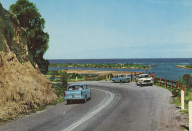
Postcard - Princes Highway Lakes Entrance, AFK International Publishers, 1970 c
Parking bay for viewing the Entrance situated on a sharp bend of the Princes Highway. Also in image part of Bullock Island and New Works area. Three motor cars in picture, post and rail safety fence Lakes Entrance Victoria. Also three colour postcards of same view showing progress at parking bay to steel mesh fence and steel guard rails numbers 04206.1, size 9 x 14 cm, 04206.2, 04206.3 size 10 x 14.5 cmColour postcard showing parking bay for viewing the Entrance situated on a sharp bend of the Princes Highway. Also in image part of Bullock Island and New Works area. Three motor cars in picture, post and rail safety fence Lakes Entrance Victoriacivil engineering, islands, waterways, gippsland lakes, vehicles -
 Lakes Entrance Historical Society
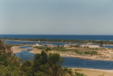
Photograph - Bullock Island Lakes Entrance, M Holding, 1988 c
Kalimna Heights showing development on Bullock Island including Pecks Factory. The Club Spit of dredged sand is acquiring vegetation. April Hamer dredge moored at Port Jetty, new bridge in place Lakes Entrance VictoriaAlso two colour photographs showing dumped sand on Bullock Island taken from Princes Highway lower parking bay June 2000. Donor L P Newspaper number 04209.1 size 10 x 15 cm and 04209.2 size 10 x 15 cm|Two colour photographs of Gippsland Ports Facilities taken from waterway numbers 04208.3 and 04208.4 size 10 x 15 cmColour photograph taken from Kalimna Heights showing development on Bullock Island including Pecks Factory. The Club Spit of dredged sand is acquiring vegetation. April Hamer dredge moored at Port Jetty, new bridge in place Lakes Entrance Victoriaislands, waterways, gippsland lakes -
 Lakes Entrance Historical Society
Postcard, H D Bulmer, Princes Highway Lakes Entrance Victoria, c1930
Black and white postcard showing part of Princes Highway below Jemmys Point, undeveloped Bullock Island New Works area and Entrance in distance Lakes Entrance VictoriaLakes Entrance Gippsland Lakesroads and streets, transport, township, waterways