Showing 369 items matching "historic information"
-
 Warrnambool and District Historical Society Inc.
Journal, Baulch, Early 20th century
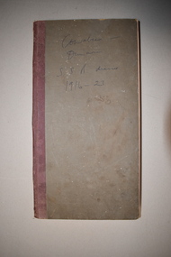
... historic property of Dunmore, between Macarthur and Hawkesdale and in 1910 he purchased the property of Cowabee in the Riverina district in N.S.W. Stan Baulch managed Cowabee for some years before inheriting part of Dunmore which he named Rose Park. Cowabee was sold in 1922. Although only a few pages in length, this diary contains much interesting information ...This ledger’s first owner was Rolf Crawley, an architect and the official engineer for the Shire of Warrnambool from 1935 to 1968. His grandfather, father and uncle also worked for the Shire of Warrnambool, with the family members recording a total of 132 years of service to the Shire. Stan Baulch later acquired the ledger, tore out the pages that had been used and recorded some aspects of his life from 1916 to 1923. Stanley Baulch (1897-1980) was the grandson of pioneer Kirkstall settlers, Francis and Ann Baulch and the son of Samuel and Eliza Baulch. In 1893 Samuel Baulch acquired the historic property of Dunmore, between Macarthur and Hawkesdale and in 1910 he purchased the property of Cowabee in the Riverina district in N.S.W. Stan Baulch managed Cowabee for some years before inheriting part of Dunmore which he named Rose Park. Cowabee was sold in 1922. Although only a few pages in length, this diary contains much interesting information on the early years of Stan Baulch at the homesteads of Cowabee and Dunmore. It will be useful for research purposes.This is a hard cover ledger with a dark grey cover and dark red binding. It contains pages printed with the name and address of the Shire of Warrnambool Engineer, Rolf Crawley. These pages contain two sections to a page ruled with blue lines to be used for short letters or invoices (originally 500 sections). The ledger also has blank pink pages used for duplicate copies. The first 42 sections have been torn out. Twenty of the pages have handwritten material in blue ink and these are biographical notes about the years 1916 to 1923 written in the ledger at a later date by Stan Baulch.Cowabee-Dunmore S.S.B. diaries 1916-23stanley baulch, cowabee & dunmore properties, rolf crawley, history of warrnambool -
 Warrnambool and District Historical Society Inc.
Documents, Letters to Sliding Gunter, 1902
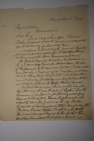
... information from various sources. These letters as they relate to one of Warrnambool's earliest writers hold historic and social significance. sliding gunter 002192.1 dated 27 Feb 1902, Koroit. ...Sliding Gunter was the nom de Plume of Thomas Hamilton Tracey Osborne. Thomas Hamilton Tracey Osborne was born at Belfast 4/9/1851, the son of Thomas Hamilton Trail Osborne and his second wife Eliza nee Treacey. The young Thomas spent many hours among seamen and ships at Port Fairy. He moved to Warrnambool and commenced work as secretary to the Western Steam Navigation Company becoming manager in 1883. After the company failed he joined with Mark Saltau and they traded as Saltau and Osborne. His writings as Sliding Gunter appeared in The Warrnambool Standard and the Belfast Gazette. He was knowlegable and maintained an interest in shipping and the sea. He died in 11th December 1902 and his body was taken on board the Julia Percy and was buried at sea out from the Breakwater. He was well liked in the district and people lined the Cannon Hill area and the foreshore to farewell him. As an avid writer he corresponded with many people and this letter is one such letter The writer J J Crawford from Koroit tells the story of some of his family and their travels to Australia and early years in South Australia. The contents of letters such as these show he drew information from various sources.These letters as they relate to one of Warrnambool's earliest writers hold historic and social significance.002192.1 Plain white paper letter handwritten in black ink on back and front of letter 002192.2 Plain white paper letter handwritten in black ink on front and section on the back written sideways. Both letters are in the same hand.002192.1 dated 27 Feb 1902, Koroit. Signed J J Crawford 002192.2 Dated 1 March 1902, Koroit.sliding gunter -
 Warrnambool and District Historical Society Inc.
Book, Subdivision No 1 to 1420, 1930s
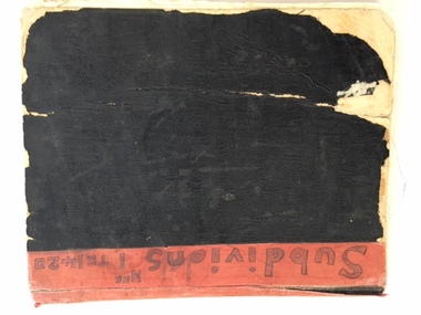
... information would be held in the Warrnambool City Council offices per electronic data storage. Warrnambool, founded in 1847, became a Municipality in 1856, a Borough in 1863, a Town in 1883 and a City in 1918. Subdivisions of land in the city continue to be made regularly for housing and business purposes. This book is of great historic ...This is an exercise book listing subdivisions in Warrnambool from 1935 to 1977. There are 1420 entries. It gives details of the subdivisions – plan number, street, section number, allotment number, date, owner, solicitor and Titles Office number. The book is completely filled and today this information would be held in the Warrnambool City Council offices per electronic data storage. Warrnambool, founded in 1847, became a Municipality in 1856, a Borough in 1863, a Town in 1883 and a City in 1918. Subdivisions of land in the city continue to be made regularly for housing and business purposes.This book is of great historic interest because it details the subdivisions in the City of Warrnambool from 1935 to 1977. It shows the continuing growth of the city, particularly after World War Two. It will be a very useful resource for researchers. This is an exercise book with a black cardboard cover and red binding. It contains a list of City of Warrnambool subdivisions from 1935 to 1977. The cover and some of the pages are torn and ragged and the binding has come apart and has been glued together in places. The pages are ruled with blue and red lines. The pages contain handwritten material in black and blue ink. Front Cover: ‘Subdivions(sic), Nos 1 to 1420’ Inside Front Cover: ‘City of Warrnambool Subdivisions’ warrnambool city council, warrnambool subdivisions -
 Warrnambool and District Historical Society Inc.
Booklet, Port Fairy Historical Society, Historic Buildings of Port Fairy, 2012
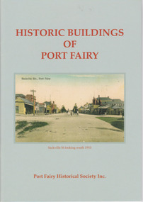
... historic buildings, many with accompanying photographs. These include many buildings in Gipps and Sackville Streets, the Powder Magazine, some hotels, the Drill Hall, Dublin House, the Port Fairy Cemetery and several schools and churches. This booklet is useful for those seeking quick information ...Port Fairy, a small town in Western Victoria established in 1836, has an exceptional collection of public buildings and dwellings dating from the 1840s. This booklet gives short descriptions of 58 of these historic buildings, many with accompanying photographs. These include many buildings in Gipps and Sackville Streets, the Powder Magazine, some hotels, the Drill Hall, Dublin House, the Port Fairy Cemetery and several schools and churches. This booklet is useful for those seeking quick information on the historic buildings in Port Fairy and for those wanting to undertake a walk around the town’s historic spots. TryBooking will show you the full breakdown on the Booking Payment Report and the Event Revenue Itemised Report so you can clearly see the ticket sales, credit card processing fee and the funds that are yours. Front cover: ‘Historic Buildings of Port Fairy, Port Fairy Historical Society Inc.’ Photograph on front cover: ‘Sackville Str. Port Fairy’, ‘Sackville St. looking south 1910’ Back cover map: ‘Port Fairy Historic Buildings’ warrnambool, port fairy, western victoria, historic buildings -
 Bendigo Military Museum
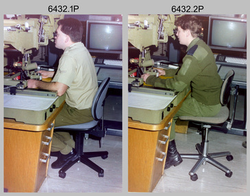
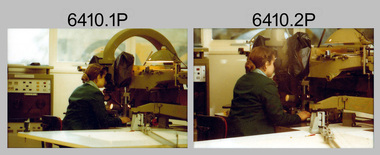
Photograph - Capturing Topographic Features with a Wild B8, AUTOMAP 2 Systems Operations – Army Survey Regiment, Fortuna, Bendigo, 1990
... Refer to item 6185.4P and 6204.8P for detailed information and additional photographs of the Wild B8 stereo plotter. The history of the AUTOMAP 2 system is covered in more detail with additional historic photographs in pages 119, 137-142 and 180 of Valerie Lovejoy’s book 'Mapmakers of Fortuna – A history of the Army Survey Regiment’ ISBN 0-646-4: 2120-4. ...Refer to item 6185.4P and 6204.8P for detailed information and additional photographs of the Wild B8 stereo plotter. The history of the AUTOMAP 2 system is covered in more detail with additional historic photographs in pages 119, 137-142 and 180 of Valerie Lovejoy’s book 'Mapmakers of Fortuna – A history of the Army Survey Regiment’ ISBN 0-646-4: 2120-4. ...This is a set of two photographs of Air Survey Squadron technicians - LCPL Peter Murphy and SPR Rachel (Stanford) Scott capturing topographic features with a Wild B8 stereo plotter with AUTOMAP 2 equipment at the Army Survey Regiment, Fortuna, Bendigo, c1990. Refer to item 6185.4P and 6204.8P for detailed information and additional photographs of the Wild B8 stereo plotter. The history of the AUTOMAP 2 system is covered in more detail with additional historic photographs in pages 119, 137-142 and 180 of Valerie Lovejoy’s book 'Mapmakers of Fortuna – A history of the Army Survey Regiment’ ISBN 0-646-4: 2120-4. See items 6087.10P and 6223.23P for additional photographs of the AUTOMAP 2 system.This is a set of two photographs of Air Survey Squadron technicians capturing topographic features with a Wild B8 stereo plotter with AUTOMAP 2 equipment at the Army Survey Regiment at Fortuna, Bendigo, c1990. The photographs are on 35mm negative film. They are part of the Army Survey Regiment’s Collection. The photographic negatives were scanned at 96 dpi. .1) - Photo, colour, 1990. LCPL Peter Murphy operating a Wild B8 stereo plotter. .2) - Photo, colour, 1990. SPR Rachel (Stanford) Scott operating a Wild B8 stereo plotter..1P to .2P – no annotationsroyal australian survey corps, rasvy, army survey regiment, army svy regt, fortuna, asr, photogrammetry -
 Warrnambool and District Historical Society Inc.
Book, Historic Places of South West Victoria
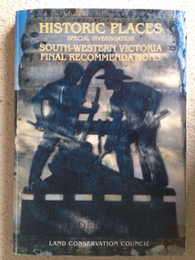
... The Final Recommendations include information on processes for protection of historic places, lists of significant places in the south-western region and aboriginal historic places. ...The Final Recommendations include information on processes for protection of historic places, lists of significant places in the south-western region and aboriginal historic places. ...This is the third in a series of booklets produced by the Land Conservation Council in 1997 (176 pages). Booklets One and Two (1996) contained A Descriptive Report and Proposed Recommendations. The Final Recommendations include information on processes for protection of historic places, lists of significant places in the south-western region and aboriginal historic places. Attached inside the back cover are two maps showing the location of the significant places.This is a useful book as it lists the declared historic sites in the region and researchers will find the information helpful. This is a soft-cover book with a multi-coloured cover featuring a photograph of the Pioneers Memorial, Deep Lead. It has a red-coloured spine and back cover.Front Cover – Historic Places - Special Investigation - South-Western Victoria - Final Recommendations – Land Conservation Council Spine – Historic Places – South-Western Victoria – Final Recommendations – Land Conservation Council Back Cover – Historic Places, Final Rec., code used for retail sales warrnambool, south west historic places, aboriginal historic places -
 Bendigo Military Museum
Photograph - AITA Award - RA Svy’s AUTOMAP 2 Computer Based Map Production System, Army Survey Regiment, Fortuna, Bendigo, 1984
... historic photographs is covered in pages 119, 137-143 and 157 of the 'Mapmakers of Fortuna’ book. See item 6223.23P for additional history and photographs of the AUTOMAP 2 system. Royal Australian Survey Corps RASvy Army Survey Regiment Army Svy Regt Fortuna .1P to .3P –No personnel are identified. ‘AITI Award to AUTOMAP II 1984’ annotated on cover sleeve. This collection of three photos of the Australian information ...This collection of three photos of the Australian information Technology Award (AITA) won by the Royal Australian Survey Corps (RA Svy) AUTOMAP 2 computer-based map production system, was taken in 1984 at the Army Survey Regiment, Fortuna, Bendigo. The following article appeared in the ARMY Newspaper on Thursday 21st February 1985. ‘In computerised map production. Survey soldiers lead the world. BENDIGO: Army surveyors have been put on the map as world leaders in computerised map production following the Australian information Technology Awards. RA Svy won the Computer Assisted Draughting – Mapping section for its Automap II System which has created considerable interest among overseas defence experts. The award for the digital mapping system was accepted by OC Air Survey Sqn, MAJ Rob John, who said it was a great morale-booster for the soldiers of the Bonegilla (sic)* -based Army Survey Regiment. "Setting up a state-of-the-art system like Automap II. is an enormous task, " he said. "We started in August 1983 and it's only recently that we have achieved production results. "We were all very pleased to have our efforts recognised in this way. “Of course, credit must also go to the Intergraph Corporation for manufacturing the system and carrying out most of the development." RA Svy is responsible for producing all of Australia's maps used for defence purposes. Its topographical maps have a scale of 1:50,000 or 1:100,000 although Automap II has the capability of producing smaller scale maps - down to 1: 2,000,000. Automap II consists of three computers and three sub-systems: input, raster scanning, and graphic edit. The input sub-system has eight stereo plotters, two interactive graphic workstations and a system manager workstation. The stereo plotters use superimposition optics to digitise features from aerial photographs. It incorporates a voice recognition system so the operator can simply say "House", "Windmill", etc; and the relevant feature will be incorporated in the digital picture. Individual map separations are scanned and converted by the raster scanning sub-system to a digital raster image. This image is then converted to a graphics file in Intergraph format.’ *Note – the Army Survey Regiment was located in Bendigo, not Bonegilla as incorrectly stated in the article. The article appears on Page 137 of Valerie Lovejoy’s book 'Mapmakers of Fortuna – A history of the Army Survey Regiment’ ISBN: 0-646-42120-4. Additional history of the AUTOMAP 2 system with historic photographs is covered in pages 119, 137-143 and 157 of the 'Mapmakers of Fortuna’ book. See item 6223.23P for additional history and photographs of the AUTOMAP 2 system.This collection of three photos of the Australian information Technology Award (AITA) won by the Royal Australian Survey Corps (RA Svy)’s AUTOMAP 2 computer-based map production system, was taken in 1984 at the Army Survey Regiment, Fortuna, Bendigo. The photographs are printed on photographic paper and are part of the Army Survey Regiment’s Collection. The black and white photographs were scanned at 300 dpi. .1) - Photo, black & white, 1984, AITA Award sitting between the dual screens of an AUTOMAP 2 Graphic Edit Workstation. .2) - Photo, black & white, 1984, MAJ Job Johns (centre) and two of Intergraph Corporation IT engineers proudly hold the AITA Award next to an AUTOMAP 2 Graphic Edit Workstation. .3) - Photo, black & white, 1984, The AITA Award displayed on a pedestal in the Army Survey Regiment Officers Mess. .1P to .3P –No personnel are identified. ‘AITI Award to AUTOMAP II 1984’ annotated on cover sleeve. royal australian survey corps, rasvy, army survey regiment, army svy regt, fortuna -
 Kiewa Valley Historical Society
Photograph - Tawonga Valley 1937, 06/05/1937
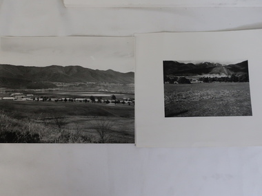
... Kiewa Valley Historical Society Mount Beauty Information Centre 31 Bogong High Plains Rd Mt Beauty high-country Hume and Hovell discovered the area in 1824 and by the end of the 19th century the valley was transformed by logging, dairy and beef cattle properties and tobacco farms. Historic ...Hume and Hovell discovered the area in 1824 and by the end of the 19th century the valley was transformed by logging, dairy and beef cattle properties and tobacco farms. Historic photograph of the Tawonga Valley as it appeared in May 1937Black and white photograph of Tawonga Valley looking towards Mt BeautyHandwritten on rear of photograph in pencil - Thursday May 6th, 1937. Tawonga Valleytawonga, kiewa valley -
 Kiewa Valley Historical Society
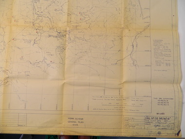
Plan - Kiewa Scheme General Plan 1958, S.E.C.V. Design & Construction Dept. Civil Branch, Dec. 1958
... Information Centre 31 Bogong High Plains Rd Mt Beauty high-country The Kiewa Hydro Electric Scheme was constructed by the State Electricity Commission of Victoria. Draftsmen drew up the plan of the layout as per the instructions from the engineers. The plan was drawn up on a transparency sheet and paper prints run off on a 'dyeline' copier. The 'Chief draftsman' and 'Design engineer' and 'Civil engineers recommended it and approved it. Historic ...The Kiewa Hydro Electric Scheme was constructed by the State Electricity Commission of Victoria. Draftsmen drew up the plan of the layout as per the instructions from the engineers. The plan was drawn up on a transparency sheet and paper prints run off on a 'dyeline' copier. The 'Chief draftsman' and 'Design engineer' and 'Civil engineers recommended it and approved it. Historic: This plan gives a time line for the work on the Kiewa Hydro Electric Scheme. It is a good example of the work of a draftsman and the copying process in 1958.Large topography map of the area covered by the Kiewa Hydro Electric Scheme in 1958. Mountain peaks are marked in red and named. Rivers, roads, construction infrastructure as well as the main areas / names of construction are named. Signed and dated by employees of the S.E.C.V. working on the scheme.state electricity commission of victoria., kiewa hydro electric scheme, plan, engineer, draftsman -
 Bendigo Military Museum
Photograph - Capturing Topographic Features with a Wild B8, AUTOMAP 1 Systems Operations – Army Survey Regiment, Fortuna, Bendigo, 1980
... Refer to item 6204.8P for detailed information and additional photographs of the Wild B8 stereo plotter. The history of the AUTOMAP 1 system is covered in more detail with additional historic photographs in pages 116-118 of Valerie Lovejoy’s book 'Mapmakers of Fortuna – A history of the Army Survey Regiment’ ISBN: 0-646-42120-4. ...Refer to item 6204.8P for detailed information and additional photographs of the Wild B8 stereo plotter. The history of the AUTOMAP 1 system is covered in more detail with additional historic photographs in pages 116-118 of Valerie Lovejoy’s book 'Mapmakers of Fortuna – A history of the Army Survey Regiment’ ISBN: 0-646-42120-4. ...This is a set of 24 photographs of Air Survey Squadron technicians capturing topographic Features with a Wild B8 stereo plotter and operating AUTOMAP 1 equipment at the Army Survey Regiment at Fortuna, Bendigo, 1980. 17 of these photographs were taken of SPR Nick Van Dalen and SPR Santina (Argetto) Straube capturing topographic features – plotting with a Wild B8 stereo plotter were most likely taken in 1980. See item 6185.4P for black & white copies of photos of SPR Santina (Argetto) Straube operating the Wild B8 stereo plotter. Refer to item 6204.8P for detailed information and additional photographs of the Wild B8 stereo plotter. The history of the AUTOMAP 1 system is covered in more detail with additional historic photographs in pages 116-118 of Valerie Lovejoy’s book 'Mapmakers of Fortuna – A history of the Army Survey Regiment’ ISBN: 0-646-42120-4. See items 6122.20P, 6183.19P, 6184.20P, 6200.5P, and 6222.17P for additional photographs of the AUTOMAP 1 system.This is a set of 24 photographs of Air Survey Squadron technicians capturing topographic features with a Wild B8 stereo plotter and operating AUTOMAP 1 equipment at the Army Survey Regiment at Fortuna, Bendigo, c1980. The photographic proofs were printed on photographic paper and are part of the Army Survey Regiment’s Collection. The photographic proof prints were scanned at 600 dpi. .1) to .8) Photo, black & white, 1980. SPR Santina (Argetto) Straube operating a Wild B8 stereo plotter. .9) to .17) Photo, black & white, 1980. SPR Nick Van Dalen operating a Wild B8 stereo plotter. .18) to .24) Photo, black & white, 1980. CPL Gerry Gunn undertaking AUTOMAP 1 computer system duties..1P to .24P – no annotations.automap 1, royal australian survey corps, rasvy, army survey regiment, army svy regt, fortuna, asr, photogrammetry -
 Kiewa Valley Historical Society
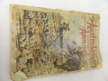
Book - Historical, The Australasian Pictorial Annual 1934, Vol. 3, October 1. 1934
... Kiewa Valley Historical Society Mount Beauty Information Centre 31 Bogong High Plains Rd Mt Beauty high-country This book was printed in 1934, giving an insight into journalism, advertising, fashion, opinions, issues, photography of the time. It also shows areas and buildings within Australia in 1934 allowing a comparison before and after this date. Historic ...This book was printed in 1934, giving an insight into journalism, advertising, fashion, opinions, issues, photography of the time. It also shows areas and buildings within Australia in 1934 allowing a comparison before and after this date. Historic: Comparison of areas etc. in Australia to areas etc. within the Kiewa Valley.Large book with stiff paper coloured cover showing a mob of sheep. Tattered discoloured pages with coloured and black and white photos and print of different areas within Australia.Inserted inside the book - a copy of 'The Sydney Cove Chronicle' dated 30th June, 1790 and printed December 1969. newspaper. pictorial annual 1934. -
 Kiewa Valley Historical Society
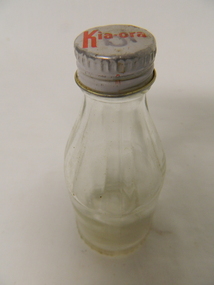
Bottle - Cordial
... Kiewa Valley Historical Society Mount Beauty Information Centre 31 Bogong High Plains Rd Mt Beauty high-country Cordial was bought at the local general store or at a grocery shop in a near-by city. Bottles belonged to the manufacturer and came in many shapes and sizes with a variety of lids. Historic ...Cordial was bought at the local general store or at a grocery shop in a near-by city. Bottles belonged to the manufacturer and came in many shapes and sizes with a variety of lids.Historic: Size and shape of bottle The Kia-ora CompanySmall clear glass bottle with white screw-top tin lid. The bottle has straight sides half way up then tapers gradually to the opening. The lid has red writing on the top.On lid: Kia-ora Embossed around bottom of bottle: Kia-ora Not to be Refilled. On base:1/07 in centre. m on one side and 4 on the other, Under the centre: '1080'cordial bottle; kia-ora company -
 Kiewa Valley Historical Society
Sign - S.E.C.V. x 2
... Kiewa Valley Historical Society Mount Beauty Information Centre 31 Bogong High Plains Rd Mt Beauty high-country This sign warned people not to go near electric wires. Consequences are explained. Public Health & Safety has changed over the years as have the consequences. Historic ...This sign warned people not to go near electric wires. Consequences are explained. Public Health & Safety has changed over the years as have the consequences. Historic: Used by the S.E.C. on the Kiewa Hydro Electric Scheme. White metal sign with black and red writing warning people to keep away from electrical wires.(In black unless stated differently) "State Electricity Commission / of Victoria / Danger (red) / Contact with electric wires will cause Death (last word in red) / 10 pound reward paid for information leading to / Conviction for damaging commission's property / Maximum penalty Imprisonment for / 10 years. By order L G Morrison / Secretary"state electricity commission of victoria; warning sign; public health and safety; kiewa hydro electric scheme -
 Kiewa Valley Historical Society
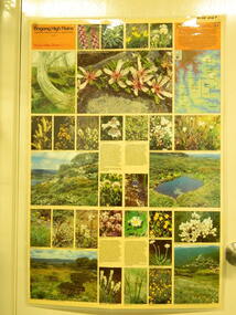
Map / Chart, Vegetation Map & Guide to Alpine Flora: Rocky Valley, 1982
... Its significance is due to it shows the flora of the area after the Kiewa Hydro Electric Scheme Rocky Valley damn has been build and therefore is a valuable for comparison to see what plants are there now after this information on this poster was complied. Historic: Comparison of the flora at Rocky Valley with other areas on the Victorian High Plains and with Rocky Valley before and after the Kiewa Hydro Scheme and / or grazing there. ...This poster is of Rocky Valley is on the Victorian High Plains where the State Electricity Commission of Victoria worked on the Kiewa Hydro Electric Scheme and also where cattlemen brought their cattle up during summer at various times. Its significance is due to it shows the flora of the area after the Kiewa Hydro Electric Scheme Rocky Valley damn has been build and therefore is a valuable for comparison to see what plants are there now after this information on this poster was complied. Historic: Comparison of the flora at Rocky Valley with other areas on the Victorian High Plains and with Rocky Valley before and after the Kiewa Hydro Scheme and / or grazing there. Is therefore research significance and interpretive capacity due to this compatibility value.Laminated double sided vegetation map and guide to the Alpine flora of the Rocky Valley area, with photographs of plants and vegetation.rocky valley. alpine. flora. vegetation. plants. s.e.c.v.. cattlemen. victorian high plains. -
 Kiewa Valley Historical Society
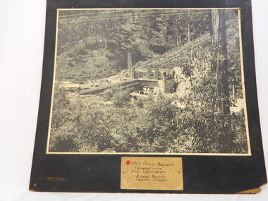
Photo of No. 3 Power Station at Kiewa Hydro Electric Scheme, No. 3 Power Station at Kiewa Hydro Electric Scheme
... Information Centre 31 Bogong High Plains Rd Mt Beauty high-country The State Electricity Commission of Victoria were the employers of the Kiewa Hydro Scheme. The work included building dams, power stations and the infrastructure for the work and their employees. Mt Beauty and Bogong village were the places where this scheme was built and where this photo shows part of its construction being Power Station 3. Originally there were 3 Hydro stations built from the 1930's onwards. The scheme finished being built in 1960 and is the biggest Hydro electricity scheme in Victoria. This photo has good Historic ...The State Electricity Commission of Victoria were the employers of the Kiewa Hydro Scheme. The work included building dams, power stations and the infrastructure for the work and their employees. Mt Beauty and Bogong village were the places where this scheme was built and where this photo shows part of its construction being Power Station 3. Originally there were 3 Hydro stations built from the 1930's onwards. The scheme finished being built in 1960 and is the biggest Hydro electricity scheme in Victoria. This photo has good Historic significance: The construction of No. 3 Power Station which was part of the Kiewa Hydro Electric Scheme built by the State Electricity Commission of Victoria. Therefore is picture is very historically significant as it shows the power station at the time of its construction which is an important part of Victoria' development and history. Since Mt Beauty was established due to the Hydro scheme being built this photo has great interpretation capacity. This is a black and white photograph showing the power station and workmen's huts and storage huts, site manager's office and surrounding bush. The photo is mounted on black painted 3 ply board. no.3 power station. kiewa hydro electric scheme. s.e.c.v..electricity. -
 Kiewa Valley Historical Society
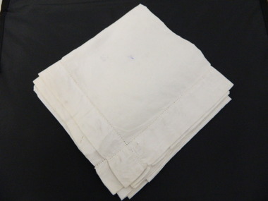
Veil - Nurse's
... Information Centre 31 Bogong High Plains Rd Mt Beauty high-country This nurses veil is preventative of what was part of nurses uniforms in the mid 1900's. Tawonga and district hospital was the only hospital in the Upper Kiewa Valley and was then moved to Mt Beauty to cater for the increased population due to the Kiewa Hydro Scheme. Many of the hospital equipment KVHS has in its collection is from the time when the hospital was moved to Mt Beauty. This veil could also be from this period. This has historic ...This nurses veil is preventative of what was part of nurses uniforms in the mid 1900's. Tawonga and district hospital was the only hospital in the Upper Kiewa Valley and was then moved to Mt Beauty to cater for the increased population due to the Kiewa Hydro Scheme. Many of the hospital equipment KVHS has in its collection is from the time when the hospital was moved to Mt Beauty. This veil could also be from this period.This has historic significance due to being representative of what nurses wore in the Tawonga and district hospital during the mid 1900's. As KVHS has many hospital instruments in its collection from the towns hospital the veil has good interpretive capacity and is in a good condition to be placed on display. White linen fabric with 3-4 cm bound edging.nurse's uniform. civilian uniform. veil. headwear. tawonga and district hospital. -
 Kiewa Valley Historical Society
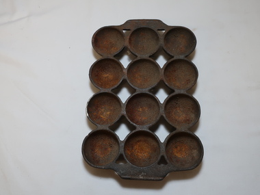
Baking Tray
... Kiewa Valley Historical Society Mount Beauty Information Centre 31 Bogong High Plains Rd Mt Beauty high-country This baking tray may have been used for cooking a variety of foods eg. muffins, scones, cupcakes etc. Nowadays trays are not so heavy as they are made from lighter metal and can be non-stick This tray is historic as it is made from cast iron compared to light metal trays with non stick surfaces in use today. ...This baking tray may have been used for cooking a variety of foods eg. muffins, scones, cupcakes etc. Nowadays trays are not so heavy as they are made from lighter metal and can be non-stick This tray is historic as it is made from cast iron compared to light metal trays with non stick surfaces in use today. Used by a resident of the Kiewa Valley.Heavy Cast Iron Baking Tray with 12 'cups' joined at the top and with a small 'handle' at each end.cast iron baking tray, cooking -
 Kiewa Valley Historical Society
Photos x2 - Views of Mt Beauty
... Kiewa Valley Historical Society Mount Beauty Information Centre 31 Bogong High Plains Rd Mt Beauty high-country The State Electricity Commission of Victoria constructed the Mt Beauty township as part of their construction of the Kiewa Hydro Electric Scheme. Historic ...The State Electricity Commission of Victoria constructed the Mt Beauty township as part of their construction of the Kiewa Hydro Electric Scheme.Historic photos of the development of the Mt Beauty township2 B & W Photos. 1. Large - early photo of houses in front of pondage (taken for what is now the golf course). 2. Medium size - looking south towards Mt Beauty township with Mt Arthur in the backgroundOn back.1. Laurie Richards No. LH 1405 2. Laurie Richards No. Copy 518mt beauty township, laurie richards -
 Kiewa Valley Historical Society
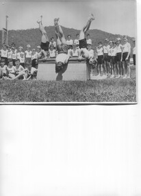
Photos - Gray-Y Club Activities x 39, Gray -Y
... Information Centre 31 Bogong High Plains Rd Mt Beauty high-country Gray-Y Boys Gymnastics club. See KVHS 1557; "Below Bogong - A History of Mount Beauty" compiled by Di Edmondson Chapter 9, Page 298 and "The Story of Kiewa" by Alex McCullough. Early sporting and fitness club for Mt Beauty for boys and men. See KVHS 1557. This activity is of historic ...Gray-Y Boys Gymnastics club. See KVHS 1557; "Below Bogong - A History of Mount Beauty" compiled by Di Edmondson Chapter 9, Page 298 and "The Story of Kiewa" by Alex McCullough.Early sporting and fitness club for Mt Beauty for boys and men. See KVHS 1557. This activity is of historic and social significance and can be compared with activities of today especially as Mt Beauty was built as a construction town for the Kiewa Hydro Electric Scheme and is now a small town with the added influence of tourism.This is a suite of photos pertaining to all facets of the Gray-Y programgray-y club, gymnastics club, mt beauty -
 Kiewa Valley Historical Society
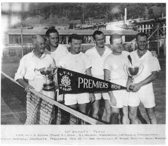
Photos - Mt Beauty Tennis Club c1950s x4
... Information Centre 31 Bogong High Plains Rd Mt Beauty high-country Mt Beauty Tennis Club circa 1956. The original 4 courts had an asphalt surface complimented by grass courts in the grassed area between the Primary School and the courts. The original 4 courts now have a synthetic surface and are still used. The grassed area is now used by the Primary school. Part of Alec McCullough's Collection. This activity is of historic ...Mt Beauty Tennis Club circa 1956. The original 4 courts had an asphalt surface complimented by grass courts in the grassed area between the Primary School and the courts. The original 4 courts now have a synthetic surface and are still used. The grassed area is now used by the Primary school.Part of Alec McCullough's Collection. This activity is of historic and social significance and can be compared with activities of today.x4 Black and white photos of tennis club members including one of 1956 A-Grade Premiersmt beauty tennis club, sport -
 Kiewa Valley Historical Society
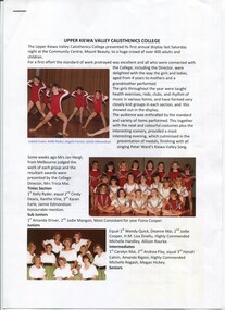
Papers - x6 The History of the Upper Kiewa Valley Calisthenics College
... Kiewa Valley Historical Society Mount Beauty Information Centre 31 Bogong High Plains Rd Mt Beauty high-country The Upper Kiewa Valley Calisthenics College was popular during the 1980s and 1990s Calisthenics was a source of exercising, socialising and competing during leisure time while living in the Kiewa Valley. This activity is of historic ...The Upper Kiewa Valley Calisthenics College was popular during the 1980s and 1990sCalisthenics was a source of exercising, socialising and competing during leisure time while living in the Kiewa Valley. This activity is of historic and social significance and can be compared with activities of today and in the past.Two pages with coloured photos refer to "The History of the UKV Calisthenics College"; x1 blue page advertising the 1983 Annual Display and x5 pages back to back re 1990 Concert including program and names of performers.ukv calisthenics, entertainment -
 Kiewa Valley Historical Society
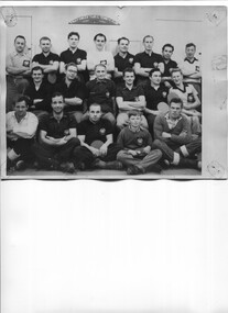
Photo - McKay Creek Table Tennis Club
... Kiewa Valley Historical Society Mount Beauty Information Centre 31 Bogong High Plains Rd Mt Beauty high-country During the construction of the Kiewa Hydro Electric Scheme the employees socialised by joining clubs such as the table tennis club. McKay Creek was the site of a power station where the employees lived in the camp while working there. Table tennis entertained them during their leisure time. This activity is of historic ...During the construction of the Kiewa Hydro Electric Scheme the employees socialised by joining clubs such as the table tennis club.McKay Creek was the site of a power station where the employees lived in the camp while working there. Table tennis entertained them during their leisure time. This activity is of historic and social significance and can be compared with activities of today especially as Mt Beauty was built as a construction town for the Kiewa Hydro Electric Scheme and is now a small town with the added influence of tourism. McKay Creek was part of the construction with a work force living there.Large Black and white photo of the McKay Creek Table Tennis Club including 18 men and 1 boy.ID on the back and "AM Collection"mckay creek power station, table tennis club, kiewa hydro electric scheme -
 Kiewa Valley Historical Society
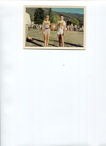
Photo - Coloured photo of Upper Kiewa Valley Sports Day
... Information Centre 31 Bogong High Plains Rd Mt Beauty high-country The schools in the Upper Kiewa Valley met annually for a combined athletics sports day. See: "Kiewa Kids" by Graham Gardner and "Below Bogong - A History of Mt Beauty" compiled by Di Edmondson There were several schools in the Upper Kiewa Valley that competed in athletics. This activity is of historic ...The schools in the Upper Kiewa Valley met annually for a combined athletics sports day. See: "Kiewa Kids" by Graham Gardner and "Below Bogong - A History of Mt Beauty" compiled by Di EdmondsonThere were several schools in the Upper Kiewa Valley that competed in athletics. This activity is of historic and social significance and can be compared with activities of today especially in relation to the number and size of participating schools.Coloured photo of a girl and boy holding a shield with other students in the back ground.upper kiewa valley schools, athletics sports day -
 Kiewa Valley Historical Society
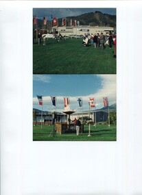
Photos - x2 Lighting the flame for Hoppet Week
... Information Centre 31 Bogong High Plains Rd Mt Beauty high-country The Kangaroo Hoppet is a long distance (42km) cross-country skiing race held annually at Falls Creek on the Bogong High Plains. The first race was held in 1979 and has been part of Worldloppet since 1991. It is held annually on the fourth Saturday of August. The event also includes the Australian Birkebeiner (21km) and the Joey Hoppet (7km). The Kangaroo Hoppet is an international event held annually on the Bogong High Plains. It is a major tourist attraction in Australia and internationally. This activity is of historic ...The Kangaroo Hoppet is a long distance (42km) cross-country skiing race held annually at Falls Creek on the Bogong High Plains. The first race was held in 1979 and has been part of Worldloppet since 1991. It is held annually on the fourth Saturday of August. The event also includes the Australian Birkebeiner (21km) and the Joey Hoppet (7km).The Kangaroo Hoppet is an international event held annually on the Bogong High Plains. It is a major tourist attraction in Australia and internationally. This activity is of historic and social significance and can be compared with activities of the past when skiing was in its infancy and when Mt Beauty was created being built as a construction town for the Kiewa Hydro Electric Scheme. It is now a small town with the added influence of tourism, the Hoppet being a major event.Two colored photos showing the lighting of the flame and the flags of participating countries at the commencement of Hoppet Week. 1990skangaroo hoppet, cross country ski race, falls creek, bogong high plains, snow sports -
 Kiewa Valley Historical Society
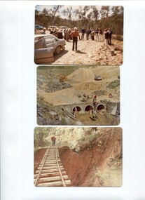
Photos - x 29 Falls Creek and Bogong High Plains
... Information Centre 31 Bogong High Plains Rd Mt Beauty high-country Photos taken by Alec McCullock circa 1980s. Some of the people include Brian Goss, Bright Shire or Water Board; Graham Cooper, Bright Shire and Paul Goldstone, Bright Shire Surveyor. Appears to be an inspection party comprising Shire, UK Water Board, SECV and other. These men represented the local organisations of the day. Historic ...Photos taken by Alec McCullock circa 1980s. Some of the people include Brian Goss, Bright Shire or Water Board; Graham Cooper, Bright Shire and Paul Goldstone, Bright Shire Surveyor. Appears to be an inspection party comprising Shire, UK Water Board, SECV and other.These men represented the local organisations of the day. Historic changes include the diversity of people who represent organisations today and the actual type of organisations that exist.Coloured Falls Creek & Bogong High Plains c 1980s. Includes SECV People and work s.e.c.v. 1980s, bright shire 1980s -
 Kiewa Valley Historical Society
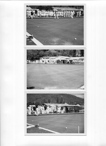
Photos - x5 Mt Beauty Bowling Club
... Information Centre 31 Bogong High Plains Rd Mt Beauty high-country The Mt Beauty bowling club commenced in 1970 and closed in 2016 when there were not enough members. See: "Below Bogong - A History of Mount Beauty" compiled by Di Edmondson Chapter 9, Page 316 The dates of the bowling club from 1970 to 2016 indicate the popularity of the sport in Mt Beauty where the demographic has changed over the period of time. This activity is of historic ...The Mt Beauty bowling club commenced in 1970 and closed in 2016 when there were not enough members. See: "Below Bogong - A History of Mount Beauty" compiled by Di Edmondson Chapter 9, Page 316 The dates of the bowling club from 1970 to 2016 indicate the popularity of the sport in Mt Beauty where the demographic has changed over the period of time. This activity is of historic and social significance and can be compared with activities of today especially as Mt Beauty was built as a construction town for the Kiewa Hydro Electric Scheme and is now a small town with the added influence of tourism.Pale colored photos of members (and visitors) of the Mt Beauty Bowling Club on the bowling green.On the back of each photo "KVHS Inc / 1 in series 5"; "2 in series 5" etc.mt beauty bowling club, sport -
 Kiewa Valley Historical Society
Article - "This Week" - History of Green Tea, Green Tea - The Facts
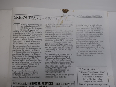
... Kiewa Valley Historical Society Mount Beauty Information Centre 31 Bogong High Plains Rd Mt Beauty high-country 'The Japanese company Ito En has been working solidly for the last five years to establish a green tea industry in this area .' The article includes assistance from the Alpine Shire, the cost and benefits of the scheme This is of historic ...'The Japanese company Ito En has been working solidly for the last five years to establish a green tea industry in this area .' The article includes assistance from the Alpine Shire, the cost and benefits of the schemeThis is of historic and social significance regarding industries in Mt Beauty and the Kiewa Valley especially as some no longer grow green tea as the affect of bush fires (smoke) made the industry not viable.Article with Title "Green Tea - The Facts" published on Page Seven from local publication "This Week" Falls Creek. Bogong. Mt. Beauty Summer Edition 21 Friday January 23rd 2004. Refers to properties of which there are 50% in the Kiewa Valley including Mt Beauty.green tea in mt beauty, japanese company ito en -
 Kiewa Valley Historical Society
Photos - Mills Family x 15
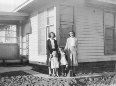
... Information Centre 31 Bogong High Plains Rd Mt Beauty high-country Brian and Jill Mills lived with their children at Lakeside Ave. Mt Beauty. Brian was in the airforce. 4 photos were taken during the construction of the Kiewa Hydro Electric Scheme. 1. The "Mills Kids" beside the river - show the fashion of the time and how families spent their recreational time. 2.& 3. The "70 Lakeside Ave" photos show the type of housing provided by the SECV and that the garden hadn't been created. 4. SEC marshalling yards, Mt Beauty c 1940s-50s. An historic ...Brian and Jill Mills lived with their children at Lakeside Ave. Mt Beauty. Brian was in the airforce.4 photos were taken during the construction of the Kiewa Hydro Electric Scheme. 1. The "Mills Kids" beside the river - show the fashion of the time and how families spent their recreational time. 2.& 3. The "70 Lakeside Ave" photos show the type of housing provided by the SECV and that the garden hadn't been created. 4. SEC marshalling yards, Mt Beauty c 1940s-50s. An historic photo of 1940s/50s buses used to transport KHES workers to their work sites, some of which were on the High Plains.15 large photos scanned in colour. 5 have labels written on the backOn the back "Brian Mills" (in airforce uniform); "Mills Kids / 78 L/side Ave"; "70 Lakeside Ave"; "70 L/side Ave" and "SEC Marshalling yards - Mt Beauty (and Donor's name and address.lakeside ave mt beauty, brian mills -
 Kiewa Valley Historical Society
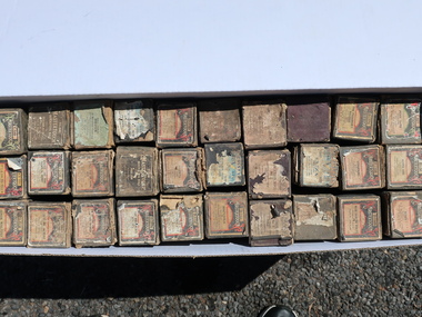
Pianola Rolls
... Information Centre 31 Bogong High Plains Rd Mt Beauty high-country Pianola roll is a music storage medium used to operate a player piano, piano player or reproducing piano. The roll moves over a reading system known as a tracker bar; the playing cycle for each musical note is triggered when a perforation crosses the bar. They have been in continuous production since at least 1896. These rolls are c1920s. Used and owned by a resident of the Kiewa Valley. An alternative form of musical entertainment in the home. The music itself is historic ...Pianola roll is a music storage medium used to operate a player piano, piano player or reproducing piano. The roll moves over a reading system known as a tracker bar; the playing cycle for each musical note is triggered when a perforation crosses the bar. They have been in continuous production since at least 1896. These rolls are c1920s.Used and owned by a resident of the Kiewa Valley. An alternative form of musical entertainment in the home. The music itself is historic and an example of what songs were popular in the 1920s.Stored in 2 boxes. Box 1. Mastertouch Rolls = 21; Universal Song Roll = 1; Vocalsty Song Roll = 3; Gulbransen Roll = 3 Box 2. Mastertouch = 2; Unidentified = 18 Most rolls are in original cardboard boxes with labels on the end. Rolls in various condition. Most rolls intact. Rolls of paper end are metal or Bakorlite, paper rolled onto a cardboard core. Boxes are dark colours. They ore continuous rolls of paper with holes punched into them. These perforations represent note control data.pianola rolls, music, entertainment -
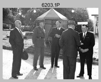 Bendigo Military Museum
Photograph - AHQ Survey Regiment Open Day, Fortuna Villa, Bendigo, c1958
... historic Fortuna Villa. In the background of photo .1P above the man on the right is a sign with the following text: ‘STAR OBSERVING EQUIPMENT.’ LTCOL Lindsay Lockwood’s period as CO is covered in more detail in pages 48-49 of Valerie Lovejoy’s book 'Mapmakers of Fortuna – A history of the Army Survey Regiment’ ISBN: 0-646-42120-4. Also refer to page 75 for more detailed information...historic Fortuna Villa. In the background of photo .1P above the man on the right is a sign with the following text: ‘STAR OBSERVING EQUIPMENT.’ LTCOL Lindsay Lockwood’s period as CO is covered in more detail in pages 48-49 of Valerie Lovejoy’s book 'Mapmakers of Fortuna – A history of the Army Survey Regiment’ ISBN: 0-646-42120-4. Also refer to page 75 for more detailed information ...This is a set of three photographs of an Open Day held at the AHQ Survey Regiment, Bendigo c1958. It’s evident in the background of these group photos there were displays of field surveying equipment. It is known an Open Day was held on the 2nd of November 1958. As the CO LTCOL Lindsay Lockwood MID is positively identified, it’s highly probable these photos were taken at that time. LTCOL Lindsay Lockwood was the CO of the AHQ Survey Regiment from 1951 to 1962. As the longest serving commanding officer of the unit, there was many changes implemented under his command. He decided an Open Day was the best way for the local community in Bendigo to gain an insight into the unit’s important role as Defence’s map production agency, its technical equipment, and its economic importance to Bendigo. It also gave them an opportunity to tour through historic Fortuna Villa. In the background of photo .1P above the man on the right is a sign with the following text: ‘STAR OBSERVING EQUIPMENT.’ LTCOL Lindsay Lockwood’s period as CO is covered in more detail in pages 48-49 of Valerie Lovejoy’s book 'Mapmakers of Fortuna – A history of the Army Survey Regiment’ ISBN: 0-646-42120-4. Also refer to page 75 for more detailed information on the Open Day held in 1958. This is a set of photographs of an Open Day held at the AHQ Survey Regiment, Bendigo c1958. The photographs were printed on photographic paper and are part of the Army Survey Regiment’s Collection. The photographs were scanned at 300 dpi. .1) - Photo, black and white. Unidentified civilian visitors, 2nd from left: LTCOL Lindsay Lockwood MID. .2) - Photo, black and white. Unidentified Army Padre (centre) and civilian visitors. .3) - Photo, black and white. Unidentified civilian visitors..1P – annotated on back ‘COL LOCKWOOD’ .2P – no annotations .3P – annotated ‘Bishop Rich-e-a-‘royal australian survey corps, rasvy, army survey regiment, army svy regt, fortuna, asr