Showing 1480 items matching "history sources"
-
 Koorie Heritage Trust
Book, C. E. Sayers (Original edition edited by Bride, Thomas Francis), Letters from Victorian pioneers : a series of papers on the early occupation of the colony, the Aborigines, etc. addressed by Victorian pioneers to His Excellency Charles Joseph La Trobe, Esq., Lieutenant-Governor of the Colony of Victoria, 1983
... . | Victoria -- History -- 1834-1900 -- Sources. | Victoria.... | Victoria -- History -- 1834-1900 -- Sources. | Victoria ...Brief notes on the contributors and incidents have been included in this edition although the above-mentioned items have been left out, some marginal notes made by Governor La Trobe have been dealt with in the footnotes. "From the original edition edited for the Trustees of the Public Library by Thomas Francis Bride'. Previously published: Melbourne : Heinemann, 1969. Originally published: Melbourne : Government Printer for the Trustees of the Public Library, Museums and National Gallery of Victoria, 1898.xiv, 455 p., 31 p. of plates : map ; 26 cm.Brief notes on the contributors and incidents have been included in this edition although the above-mentioned items have been left out, some marginal notes made by Governor La Trobe have been dealt with in the footnotes. "From the original edition edited for the Trustees of the Public Library by Thomas Francis Bride'. Previously published: Melbourne : Heinemann, 1969. Originally published: Melbourne : Government Printer for the Trustees of the Public Library, Museums and National Gallery of Victoria, 1898.pioneering, 1836-1854. victoria. correspondence, diaries, etc. | victoria. description & travel, 1836-1854. correspondence, diaries, etc. | frontier and pioneer life -- victoria. | victoria -- history -- 1834-1900 -- sources. | victoria -- description and travel -- 1851-1900. -
 Surrey Hills Historical Society Collection
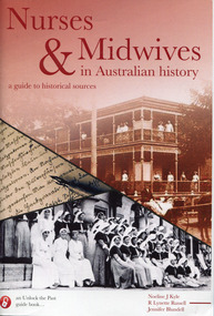
Booklet - Nurses and Midwives in Australian history: a guide to historical sources, Noeline Kyle
... history: a guide to historical sources. Booklet Nurses ...Nursing and midwifery have been the occupations of women for centuries and almost every one of us will find an ancestor who engaged in these traditional feminine pursuits. This book offers a number of different websites where you might find some helpful information including for international and government authorities, United Kingdom midwives,An A5 sized booklet of 76 pages, includes indexnon-fictionNursing and midwifery have been the occupations of women for centuries and almost every one of us will find an ancestor who engaged in these traditional feminine pursuits. This book offers a number of different websites where you might find some helpful information including for international and government authorities, United Kingdom midwives, midwives -- australia -- history, nurses -- australia -- history, obstetrics -- australia -- history, australia -- genealogy -- sources, australia -- genealogy -
 National Vietnam Veterans Museum (NVVM)
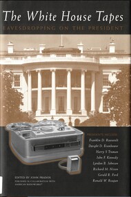
Book, Prados, John ed, The White House Tapes: Eavesdropping On The President, 2003
... Presidents -- United States -- History -- 20th century... -- History -- 20th century -- Sources President Roosevelt President ...The White House Tapes: Eavesdropping on the President is a fascinating portrait of eight recent American presidents.Box containing the book and a package of 9 Cd'sThe White House Tapes: Eavesdropping on the President is a fascinating portrait of eight recent American presidents.white house (washington, presidents -- united states -- history -- 20th century -- sources, president roosevelt, president eisenhower, president truman, president j f kennedy, president johnson, president nixon, president ford, president reagan -
 Alfred Hospital Nurses League - Nursing History Collection
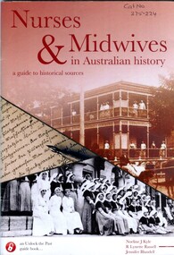
Booklet - Illustrated booklet, Noeline J Kyle 1940- et al, Nurses & Midwives in Australian History: a guide to historical resources, 2015
... Obstetrics-Australia-History Australia-genealogy-sources "Nursing ..."Nursing and midwifery have been the occupations of women for centuries and almost every one of us will find an ancestor who engaged in these traditional feminine pursuits. This book, written by experts in nursing history, women's history and family history, provides practical advice on how to research the lives of nurses and midwives, the hospitals they trained and worked in, and is a guide to the many public and private repositories where sources are found in Australia, New Zealand and the United Kingdom. Nurses and midwives worked in hospitals, refuges, asylums, prisons, charitable institutions and were pioneers of bush nursing, established maternity hospitals and were often important health providers in small communities in past decades. The records of their lives are found in a wide range of places, and as well as online and digitised records, this book also points the researcher toward the myriad of documentary and private records which are useful for writing their lives"--back cover.Illustrated booklet with brown, black and white cover, front cover has title, authors and series names, along with three historical photos, nurses standing under the verandah of a building, handwriting witl a metal nib pen, and a group of nurses wearing capes and veils. Back cover has a summary of the book along with a small black and white photograph of a nurses in uniform with long sleeves, apron and capnon-fiction"Nursing and midwifery have been the occupations of women for centuries and almost every one of us will find an ancestor who engaged in these traditional feminine pursuits. This book, written by experts in nursing history, women's history and family history, provides practical advice on how to research the lives of nurses and midwives, the hospitals they trained and worked in, and is a guide to the many public and private repositories where sources are found in Australia, New Zealand and the United Kingdom. Nurses and midwives worked in hospitals, refuges, asylums, prisons, charitable institutions and were pioneers of bush nursing, established maternity hospitals and were often important health providers in small communities in past decades. The records of their lives are found in a wide range of places, and as well as online and digitised records, this book also points the researcher toward the myriad of documentary and private records which are useful for writing their lives"--back cover. nurses-australia-history, midwives-australia-history, obstetrics-australia-history, australia-genealogy-sources -
 Greensborough Historical Society
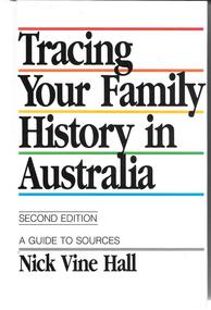
Book, Nick Vine Hall, Tracing your family history in Australia: a guide to sources. 2nd ed, 1994_
... A guide to family history/genealogy sources in Australia. ... family history in Australia: a guide to sources. 2nd ed. Book ...A guide to family history/genealogy sources in Australia. 657p.genealogy resources -
 Orbost & District Historical Society
black and white photograph, early 20th century
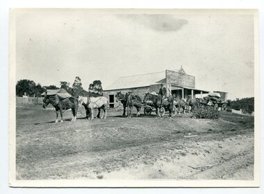
... . History sources reveal little of its beginnings, Cattlemen used.... History sources reveal little of its beginnings, Cattlemen used ...Before 1850, Bendoc was peopled by a few Chinese settlers. History sources reveal little of its beginnings, Cattlemen used the spot as a temporary watering place and Ben Boyd sometimes brought his cattle down from the Monaro High Plains to be docked. “Ben's Dock” then is a possible derivation of the name Bendoc. (info. Bendoc Progress Association)This is a pictorial record of Bendoc in the late 19th -early 20th century. It shows early horse-drawn transport.A black / white photograph of a horse-drawn wagon and a man on a horse outside a wooden building.on back - "stop before Bendoc Hotel"bendoc transport-horse-drawn -
 Bendigo Historical Society Inc.
Newspaper - LYDIA CHANCELLOR COLLECTION: CHILDREN
... related to Australian history and animals. Sources include... to Australian history and animals. Sources include 'National Geographic ...A box decorated with red Christmas paper. Contains mostly pictures of or relating to children but does contain some items related to Australian history and animals. Sources include 'National Geographic,' 'To-day' and 'Australian Women's Weekly.' Dated 1933-1955.person, individual, children, lydia chancellor, collection, ephemera, children, person, australian history, animals, female, male, person -
 Eltham District Historical Society Inc
Folder, Unpublished collection of Eltham State School No. 209 items, 1856-1995 by Harry Gilham (EDHS)
... School 209, 1856-2006, A History" Source references from... School 209, 1856-2006, A History" Source references from ...Contents 1. Draft chronology - Eltham Primary School Chronology 1856-1995; Harry Gilham (EDHS) 1995 127 pages, A4 photocopies This collection of memorabilia has a focus on the Eltham State School No. 209. It was prepared to help celebrate the 140th year of the school's existence on its original land grant of 1856, which appeared on the first surveyed land for the formation of the Town of Eltham, in the Parish of Nillumbik, County of Evelyn, granted by the then Government of New South Wales. It is inscribed in Harry Gilham's writing on page 1 - "For Eltham P.S Chronology 209 - 150th Anniv. book; Harry Gilham Collection; Unpublished" and stamped "Eltham District Historical Society" Pages 3 and 4 missing. This manuscript was a major source reference for the book "We Did Open A School In Little Eltham; Eltham Primary School 209, 1856-2006, A History" Source references from Inspector's Register of State Schools; photocopies held by EDHS in A3 binders 2. Renovation of Eltham Primary School Residence; Application of a Grant from National Estate Grants program, 17 April 1989 10 pages A4 photocopy 3. Wayfinding In The Environment; The role of aesthetics research in participatory planning design by Victoria Sharp for the School of Environmental Planning, The University of Melbourne, February 1987 4 pages, A4 photocopy extracts copied include: Synopsis Spefic Design Concerns p37 (relative to Eltham Gateway) Summary p38 4. File Record, State School No 209 - Eltham; National Trust of Australia File No B3260; 29 March 2000 1 page A4 5. Notes by Harry Gilham concerning Eltham State School No 209 1 page handwritten lined pad sheet 6. Notes by Harry Gilham concerning Eltham State School No 209 and feedback on 150th Anniversary book 1 page, A4 green 144 A4 pages As noted150th anniversary, chronology, eltham gateway, eltham primary school, eltham state school, harry gilham, national trust of australia, planning, renovation, school residence, state school no. 209, victoria sharp -
Glen Eira Historical Society
Article - Glenfern
... , local history, Boyd history and various other sources. Includes..., local history, Boyd history and various other sources. Includes ...Photocopy of typed research, undated, from an unknown author, regarding the architectural style of Glenfern, the changing landscaping from 1860, an addition to the property in 1876 and extracts from Jeannie Watson’s diary (daughter of then owner) dated 1870. Includes references from rate books, sale notices, titles, local history, Boyd history and various other sources. Includes photographs, poorly reproduced.glenfern, st kilda east, balaclava station, boyd captain, inkerman road, inkerman street, balaclava, mcdonnell francis, laing charles, architects, architectural features, boyd john t. t., gothic revival, hotham street, watson jeannie, coldham edith lucy, swanson donald, à beckett minnie, ostberg sarah ann -
Canterbury History Group
Book, Fiona Poulton et al, Boroondara Remembers: Stories of World War I, 2015
... Community History Awards 2015 (Source: Boroondara Arts website... Community History Awards 2015 (Source: Boroondara Arts website ...This brings to life the stories of the Boroondara residents who were impacted by WWI, both at home and overseas, by evocatively capturing the stories of Boroondara families and individuals whose lives were irreversibly changed by WWI. It follows the Boroondara ANZACs and their passage to war and details life at the time on the Home Front. The publication acts as a lasting legacy and provides a valuable resource for future generations.Includes photographs, notes, bibliography, archival sources and index. 211 pagesnon-fictionThis brings to life the stories of the Boroondara residents who were impacted by WWI, both at home and overseas, by evocatively capturing the stories of Boroondara families and individuals whose lives were irreversibly changed by WWI. It follows the Boroondara ANZACs and their passage to war and details life at the time on the Home Front. The publication acts as a lasting legacy and provides a valuable resource for future generations. world war 1914-1918, boroondara, oral history, personal histories, australian society -
 Ringwood and District Historical Society
Poster, Land Sale Advertisement - Pinemont Estate, Ringwood, Victoria - circa 1924
... January 1923, Ringwood to Croydon November 1924 (Source: History... 1924 (Source: History of Croydon - McGivern, Vol.1 p20). Map ...Map of residential allotments for sale, with terms of sale, summary of subdivision features and local services and facilities, and photographs of local street scene and lake (Loughnan's Lake - location not marked), Subdivision includes Wonga Road (later Loughnan's Road), Glenvale Road, Kubba Road, Felix Crescent, Summit Crescent, Pine Crescent, Aurum Crescent, Hygeia Parade, Panorama Avenue, Avalon Grove, Montalbo Road, Cielterre Avenue. Sole Agents T.M. Burke Pty Ltd, 340 Collins Street Melbourne Phones 6294, 6779. Map by S. Callanan, Licensed Surveyor, 107 Elizabeth Street Melbourne. Date of poster estimated from railway services information extract " ... 36 fast electric trains to Flinders Street daily ... proposed electrification to Croydon ..." . Timeline for electrification of Lilydale Line record indicates Box Hill to Ringwood January 1923, Ringwood to Croydon November 1924 (Source: History of Croydon - McGivern, Vol.1 p20). -
 Cheese World Museum
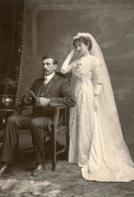
Photograph, Edward Herbert Uebergang and Alma Gertrude Schurmann, 1912
... in the Uebergang family history pp.200-208. Source: The Uebergang Families... in the Uebergang family history pp.200-208. Source: The Uebergang Families ...The Percy Uebergang family lived at Tooram Park, Allansford from 1912 until 1992. Percy and Myrtle Uebergang's children were twins, Ray and Joyce born in 1926 who lived at Tooram Park until their deaths, Ray in 1986 and Joyce in 1992. Neither Ray nor Joyce married and following the death of her brother Joyce set up the Ray and Joyce Uebergang Foundation which supports the local community. This photograph is part of the collection of items given into the care of the Cheese World Museum. Edward Herbert Uebergang and Alma Gertrude Schurmann were married on 1 March 1912. . Edward, born in 1883 at Cudgee, was the son of Friedrich Johann Uebergang and Pauline Johanna Hillbrick. Alma Gertrude was born in 1882 at Natimuk.They lived in Horsham where Edward, known as Bert, developed a chaff-cutting business servicing the Wimmera and Riverina areas. Their story is recorded in the Uebergang family history pp.200-208. Source: The Uebergang Families in Australia 1848-1985 Edward was a cousin of Percy Uebergang.Sepia photograph of the Uebergang-Schurmann wedding. The bride is standing. She is wearing a lace shawl overlay gown with elbow length lace sleeves and long white gloves. A three tiered floor length veil falls from a circlet of flowers. The groom is seated and is wearing a three piece suit, a high collared shirt and boots.allansford, cudgee, natimuk, horsham, uebergang, edward, schurmann, alma, marriages -
 Surrey Hills Historical Society Collection
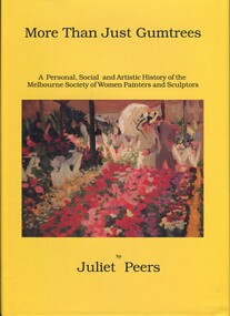
Book, More than just gumtrees: a personal, social and artistic history of the Melbourne Society of Women Painters and Sculptors, 1993
... publications; it includes hitherto unpublished sources - oral history..., in 1954, the present title was adopted. The history of the MSWPS ...Joan Richard was a speaker at the Surrey Hills Historical Society meeting in November 2013. A watercolourist, she has been a long standing member of MSWPS, Past and Recent President in 2017 and a Life Member. The Melbourne Society of Women Painters and Sculptors was founded in 1902 by women who had been students at the Art School of the National Gallery of Victoria, to provide a forum for artistic discussion and an opportunity to view and comment on each other's work. Originally named the Students' Art Club, it became "Woomballana" (meaning either 'everlasting beauty' or 'search for beauty') Art Club, The Women's Art Club, the Melbourne Society of Women Painters and finally, in 1954, the present title was adopted. The history of the MSWPS and its members’ achievements, issues of the workplace, family and art commitments, the economic survival of artists, migrant artists and prejudice against women are also explored. Much of the information in “More Than Just Gumtrees” has not been available in previous publications; it includes hitherto unpublished sources - oral history interviews, minute books, reviews, letters, early photographs. There are includes biographies of over 300 artists, with individual exhibition lists, representation in public collections etc REF: MSWPS website. Artist Mabel Pye, who lived in Surrey Hills, is one of the featured artists.A history of the Melbourne Society of Women Painters and Sculptors and of the women who have belonged since 1902. Some of these women have become well-known to the art world, other have slipped by un-noticed. Incl. index, bibliography.To the Surrey Hills/Historical Society/Presented by/Joan Richard/19th November/2013melbourne society of women painters and sculptors, women painters, women sculptors, mabel pye, joan richard -
Federation University Historical Collection
Document, Zelda Martin, Central Victorian Goldmining towns - Boom Towns or Ghost Towns?, c1996
... History: sources for aboriginal studies in the State Library...: Aboriginal Rock...." +"Koorie History: sources for aboriginal ...Zelda Martin was a PhD candidate at the University of Melbourne.[.1] 4th item in light blue display book titled Research Approach/Overview of Chapters/Confirmation of Canditure/Chapters1,2,3&4 of proposed thesis. *Twenty-seven page article on Victorian goldfields towns titled: Central Victorian Goldmining Towns - Boom Towns or Ghost Towns. The article was written during the author's PhD study. It outlines the context methodology, and resources and the chapters of the proposed thesis: (1) Central Victorian Goldmining Towns - The Context (2) Contemporary Views of the Factors Necessary for Town Growth (3) Outward Manifestations of Town Growth (4) The Trappings of Government (5-9) The Main Towns and Their Hinterland. [.2] 5th item in Light Blue display book as above item. *Chapter 1 of proposed thesis titled 'Pick, Shovel and Tin Dish Mining.' Covers in Section A: Central Victoria - Pre 1851: Aborigines in Central Victoria, Squatters, and Government. Section B: The years 1851-1854: The Early Gold Rushes, Government Reaction, Township Surveys, Legislation, Town Development, Local Government and Early Settlement. [.3] 6th item in Light Blue display book as above item. *2A of proposed thesis titled 'Contemporary Views of the Factors Necessary for Town Growth'. Similar information to Chapter 1 plus extra re towns and maps. Sections: Introduction, Context of Place - Geographical Towns Listed, The Context of Time - Pre1851 Aborigines, Governance of Port Phillip, The Squatters, The Villages of Central Victorian Highlands, Conclusion, Condensed Version of Chapter2B. [.4] 7th item in Light Blue display book as above item. *Chapter2B of proposed thesis. Sections: Area of Research, Schools, Banks, Newspapers, Progress Association, Town Development - Sandhurst (Bendigo), Ballarat, Castlemaine,, Maryborough, Ararat and Stawell. [.5] 8th item in Light Blue display book as above item. *Chapter 3 of proposed thesis titled 'Outward Manifestations of Town Growth'. Sections: Introduction, Contemporary Writing, Educationalists, The Bankers, The Townsfolk, Current Theory, General Theories of Urban Development, and Conclusion. [.6] 9th item in Light Blue display book as above item. *Chapter 4 of proposed thesis titled 'Trappings of Government' Sections: Introduction, Early Government Attitudes to Mining and Town Development, Law and Order, Township Surveys, Legislation, Local Government, Transport and Communication, The People and Lobbyists. [.7] 10th item in Light Blue display book as above item. *'The Rise and Fall of Central Victorian Goldmining Towns'. Includes a map showing main Goldfields, a table showing towns and villages at two points in time - 1857 and 1871; a Bibliography of Primary and Secondary Sources. [.8] Resource No1. Black display book titled Local Towns 1 : Alma: *Brief history *Directory *Maps Amphitheatre / Mountain Hut: *Brief History Post Office Directory Ararat: *Brief History *Post Office Directory 1869 - Alphabetical Listing by Occupation *Ararat - Prominent Citizens of 1858 *Langi-Morgala Museum Avoca: *Brief History *Excerpts from 'Avoca The Early Years', Margery and Betty Beavis; pg1 - Beginnings; pg11 - The Midas Touch; pg25 - Local Gold Escorts; pg27 - A Town is Born; pg51- The Administration of Justice; pg53 - The Ways of the Law; pg61 - News of the Day; pg65 - A Time to Play; pg72 - Land Ownership *Post Office Directory (Bailliere's) 1869 *Tourism Map and Information of area *Historic Avoca - A 5.5km Tour *Avoca & the Pyrenees Region - information pamphlet Ballarat: *Early History of Ballarat - Ballarat Historical Society, Publication No.1: origin of the name; Ballaarat - the Beginning; Fabulous Yields from the Ballaarat Goldfield; *Streetscape Lydiard Street. *Hand drawn map showing Leigh River, Old Portland Bay Road, plaque on road to Colac; etc. *Newspaper article re 'The Theatre Royal' ( which stood in the vicinity of the current Owen Williams store) - 'The News'15/04/1998 *Article - 'Ballarat's Mechanics' Institute Lives On' Ballarat Courier, 14/09/1985 *Article - Standing the Test of Time' The News 17/11/1993 re The Mechanics Institute & picture of the Reading Room *'Ballarat a Study of a City, Phyllis Reichl, pub. Nelson, 1968; no.3 place, time and people field studies series *Investigator Vol.33 No.2, 1998 Geelong Historical Society. Article on pg75 describes Ballarat in 1861 *Folded poster - 'Ballarat 100' a history of telegraph communication, pub. Telecom. Beaufort (Fiery Creek): *Brief history *Post Office Directory [.9] Resource No.2 Black Folder Titled Towns cont.No2 Bendigo (Sandhurst): *'Family & Local History at the Bendigo Library - 1851-2001 150 years of gold'. *Bendigo Government Camp in 1853 illustration; key to sketch and names of Government officers stationed there *Excerpts from 'Bendigo and Vicinity' Adolph Haman *The Bendigo Goldfield Registry - pgs 1-7 Introduction *Excerpt: 'Breaking the Grip' *Excerpt: The Most Go-Ahead Place *Excerpts from 'History of Bendigo' - anti license agitation; laying out of town; proposed railway; gold calls and dividends; the Sandhurst Municipality; journalism *Bibliography Blackwood: *Excerpts from 'Aspects of Early Blackwood - The Goldfield, the Landmarks, the Pioneers' Alan J Buckingham and Margaret F Hitchcock, JG Publishing,1980 Buninyong: *A Brief History *Investigator Vol1 No.2 Feb 1966 Geelong Historical Society. Pg3 - Article re gold escort route - Mt Alexander to Adelaide - (see a simple monument on the Western Highway a few miles out of Horsham. Pg 15 - Ballarat Excursion - re the finding of gold. *Three articles published by Buninyong and District Historical Society Inc: (Magpie Exploration; Finding Gold In The Green Hills; Magpie Exploration; Burnt Bridge to Cargarie to Mt Mercer) *Copies of newspaper articles/items *Buninyong Street Directory Carisbrook: *In the Beginning There Was Carisbrook *The History of the Carisbrook Racecourse Carngham / Snake Valley: *Brief History *Directory Castlemaine: *Directory 1865-1866 - Alphabetical and Street *Poster - Castlemaine A Contemporary Guide "The Great Centre" 1866 - A Contemporary Guide to the Fascinating Past *Pamphlet - Castlemaine District Community Hospital *Map - Castlemaine, Maldon & Surrounding Districts *Map and Information - The Dry Diggings Track - a 55kl walk among historic goldfields relics ( Castlemaine Fryerstown Vaughan Mt Franklin Hepburn Daylesford) *Postcard - Former Court House *Directory 1867 - Alphabetical, Trade [.10] Resource No.3 Grey folder Titled Towns 3 Creswick to Maryborough Creswick: *Brief History *Booklet - "Creswick Cemetery Walk" *Booklet - The Buried Rivers of Gold Heritage Trail Creswick *Creswick Historical Museum Information Sheet *Chronological History of Creswick *Alphabetical Directory of the Borough of Creswick *Creswick's Creek Directory 1856 *Historic Creswick Walking Tour *A Brief Account of the Schools of Creswick - Past and Present *100 Years of Railway Travel in Creswick *The Berry Deep Leads *The Spence Home at Jackass Gully in the Creswick State Forest ( William Guthrie Spence - Pioneer) *The New Australian Mine and the 1882 Disaster *Creswick District News, Issue 7, July August 1999 *The Creswick Miners Walk - Information and Map *Maps Chewton: *Brief History *Directory Clunes: *Brief History *Clunes Street Directory Daylesford: *Brief History *Notable Bushfires in Daylesford District Over More Than a Century - "Black Thursday" 1851; 1862; 1899; the Disastrous Hepburn Fire of 1906; 1939; 1944; 1969. *Post Office Directory -Daylesford and Hepburn Dunolly / Inkerman: *Brief History *Directory *Pamphlet - Goldfields Historical Museum *Pamphlet - Historic Dunolly - Victoria's Best Kept Secret *Map of Gold Workings at Dunolly Area - showing where the main gold rushes occurred *Brief History - Inglewood *Directory - Inglewood - Name Occupation, Dwelling Kingower: *Brief History *Directory - Name / Ocupation / Dwelling Linton / Happy Valley / Piggoreet: *Brief History *Directory - Lintons McIvor: *"A History of the Shire and the Township of Heathcote" by J.O. Randell Majorca: *Brief History *Official Post Office Directory 1869 - Name / Occupation/ Address Maldon (Tarrangower): *Brief History Part 1 *Brief History Part 2 *Post Office Directory *List - Alphabetical Order by Names plus Business and Trade (Tarrangower Times Oct/1858) *List - Alphabetical Order by Trade plus Name and Business *Directory - Name / Occupation / Dwelling Maryborough: *Worsley Cottage - built by Arthur Worsley, a contractor in stonework in 1894 [.11] Resource No. 4 Blue Display Book titled Towns 4 Moliagul to Stawell Moliagul: *Brief History *Moligul Legislative Assembly (Voting?) List - Names and Occupations *Moliagul Victorian Post Office Directory 1868 - Name / Ocupation / Address / Comments *"The Welcome Stranger" gold nugget *The Sunday School *The Welcome Stranger Discovery Walk - information and map Moonambel (Mountain Creek) Redbank *Brief History *List of names extracted from advertisments of the Pioneer and Mountain Creek Advertiser 16/02/1861. *Bailliere's Directory 1869 - Alphabetical List of Name / Occupation / Place St Arnaud: *Brief History Sebastapol: *Brief History *Directory 1869 - Alphabetical by Name; plus occupation and address. Browns and Scarsdale: *Brief History *Browns Street Directory - Name and Occupation Smythesdale: *Brief Description *Smythesdale Street Directory -Name and Occupation Stawell (Pleasant Creek) *Brief History *Victorian Official Post Office Directory - Name /Occupation / Dwelling *Chronology - 1841-1920 *Production of gold statistics - 1879 - 1900 *Big Hill *Extracts from "The Golden Years of Stawell". Chapt 1 - Stawell's Coming Out. Capt. 2 - The Gold Rush. Caapt.3 - Cradle of Democracy. Chapt.4 - The Reefs Becomes Stawell. Chapt. 5 - Rushing In. Chapt.6 - The Pioneers. Chapt 7 - The Decade of Optimism. [.12] Resource No. 5: Blue Display Book titled 'Towns Steiglitz to the The Golden Triangle. Steiglitz: Brief History Victorian Post Office Directory 1869 *Map of Steiglitz *List of maps relevant to Steiglitz history *Information 6 tables of data from "Reports of Mining Surveyors Talbot (Back Creek) Brief History Taradale: Post office Directory 1869 - Name/Occupation/Street. Also list in alphabetical order by Occupation Taradale *Chronological Reference to Taradale Mines *Water - The Coliban System of Waterworks *Joseph Brady *The Syphon Tarnagulla (Sandy Creek) *Brief History *Tarnagulla Businessmen Cameos to give depth to advertisments in 'The Tarnagulla Courier' various issues 1864-1871 *Directory - Name/Occupation /Address *List - Name/Business/Trade Wedderburn (Koorong) *Brief History *List - Name/Occupation The Golden Triangle: *The Early Rushes - Wedderburn / Moliagul / Sandy Creek - Tarnagulla / Jones Creek - Waanyarra / Kingower / Dunolly - Goldsborough / Inglweood *Census of 1857 - Population / Occupations *1858-1871 - A Time of Consolidation- Wedderburn / Moliagul / Sandy Creek- Tarnagulla / Arnold *Census 1871 - Population *Information gleaned from the census data - Demographics / Population / Occupations / marital / Birthplace / Religion / Literacy/ Occupation and Housing Cameos *Graphs - Birthplace of settlers /Male-Female Ratio / Married males / Children under 15 as Percentage of Population / Religion *Census 1857 - Statistical data *Maps *Bibliography [.13] Resource No. 6 - Black Display Book Information and Research in Central Victoria including: *Banking - Research from ANZ Bank Archives *Institutions - also includes articles listed from the Ballarat Times Newspaper *Australian mining History Association - A.M.H.A. Bibliography *Australia's Mining History * Bibliography - Land Surveys Victoria - *1853 Administration (Statistics and Other) includes: schools / ministers of religion / police / military / local administration / licences for sale of spirits / distances between various Victorian gold fields. * Victoria Government Gazette (Copy) - N0. 116, 12/12/1854 includes: Gold Felds Commission of Enquiry & No. 85, 15/09/1854 - Addresses presented to the Lieutenant Governor (Sir Charles Hotham) during his tour through the Gold Fields of Victoria,1854. Addresses on behalf of : the people of Bendigo; Members of the Church of England, Bendigo; Members of the Wesleyan Church on the Bendigo Gold Fields; Bendigo Gold District General Hospital; the Bendigo Prospecting Association; Committee of the Bendigo Local Exhibition; Bendigo District Medical Association; Coloured Americans Resident at Bendigo; German Inhabitants of Bendigo; Landowners, Inhabitants, and Miners of Castlemaine; Inhabitants of Forest Creek; Inhabitants of Heathcote and Gold Miners of McIvor; Residents and landholders of the District of Bacchus Marsh; Inhabitants of Kilmore and Vicinity. *Gold Fields Correspondence 1853: letter from Lieutenant Colonel Valiant, (Officer commanding the Troops in Victoria) to the Lieutenant Governor re threatened disturbance at Sandhurst (Bendigo) regarding the Gold License Fee. * Extracts from a book "Victoria" re Gold Fields Commission of Enquiry involving mainly Ballarat and Castlemaine and a chapter titled 'A Tour to the Victorian Gold-Fields' *Lists of central Victorian newspapers - listed by date published 1851to 1874; by first date available to State Library. *A list of cities and towns showing County, population in 1861 &1871, and municipal status. [.14] Resource no.7. Black display book. *Reference: Papers presented to Parliament Victoria - 1859-1860 4 volumes - relevant sections copied. Contains information on Branches of Government. General / Finance / Gold / Gazette / Commission and Warrant / Statistic. *Gold Fields Act. In accordance with the Act the gold fields are divided into six districts - Ballaarat, Castlemaine , Sandhurst, Avoca, Ararat, and Beechworth.. Official staff in each gold district consists of a Resident Warden, Wardens, Wardens' Clerks, Bailiffs, Chinese Protectors, Chinese Interpreters, and Mining Surveyors. *Gold Receiver *Gaols *Police magistrates and Clerks of Petty Sessions, etc. *Field Branch *Immigration and Emigration Overland - Chinese - 1859 *Population on the Goldfields *The Geological Survey - The Government Geologist is assisited by staff from four branches - the office Branch; the Publishing Branch; the Field Branch and the Museum Branch. *Commission to Enquire Into Sludge dated 10/02/1859 (Some sections copied) - Report to the Honorable Chief Commissioner of Public Works, Melbourne re the mode of carrying the sludge from the puddling mills in Sandhurst without interfering with the drainage of the town and the roads in the neighbourhood. [.15] Resource No.8: Camel display book titled Resource No. 8. Aborigines *Lists of book titles - +"Readings in Victorian prehistory" +"The Aborigines of Port Phillip" +Aboriginal languages and clans" +"A History of the Port Phillip District" +"Langi Ghiran 1: Aboriginal Rock...." +"Koorie History: sources for aboriginal studies in the State Library of Victoria", ed. Tom Griffiths, Melb. Friends of the State Library, 1989 +"The Public Lands of Australia Felix"; settlement and land appraisal in Victoria1834-91 with special reference to the Western Plains", J.M.Powell, Melb. Oxford University Press 1970 +*Bibliography of the Victorian Aborigines' from the earliest manuscripts to 31st December 1970, Massoa, Aldo, Melb. Hawthorn Press, 1971 +"Aborigines in Colonial Victoria, 1836-1886", M.F. Christie, Sydney University Press, 1979 +"Urban and Industrial Australia: readings in Human Geography" ed J.M. Powell, Melb. Sorrett Pub. 1974 *Extracts: -Processes of Pioneer Settlement - The Squatting Occupation of Victoria, 1834-60. J.M. Powell -Areal Variations in the Class Structure of the Central-Place Hierarchy. P. Scott - Volume1 and Volume 2: Notes Relating to the Habits of the Natives of Other Parts of Australia and Tasmania. Compiled from various sources for the Government of Victoria by R Brough Smyth. John Curry, O'Neil, Melb. 1st pub. Melb. 1876. p31-45 - Numbers and Distribution of the Aborigines in Victoria -Victorian Aborigines 1835-1901 - A Resource Guide to the Holdings of the Public Record Office, Victoria; published by the Government Information Centre 1984. *History of the Aboriginal Artefacts Displayed in the Daylesford Museum. F. G. Powell (4 page pamphlet) *Letter to Zelda Martin from Peter Lovett, Cultural Officer, Ballarat & District Aboriginal Co- Operative, 05/02/1997 *Map: Ian Clarke Victorian Tribunal Boundary Map - Clans of Central Victoria. *Victorian Rock Art and Mythology - Article about Mount Langhi Ghiran and myths of the Tjapwarong people. *Two Aboriginal myths relating to the Grampians - 'The Monster Emu' / 'The Aquisition of Fire', by the Aborigines in the Grampians Areas *Article titled (chapter 8) Ballarat - information re camping sites in the region. Lake Wendouree / Lake Burrumbeet (includes a myth) / Mt Bunninyong / Lal Lal / Pitfield / Mount Elephant / Mount Egerton / Meredith / Lake Goldsmith / Lake Learmonth / Ercildoune *Notes on the Aborigines of the Wider Ballarat Region plus European names=Aboriginal names. John Morris 26/07/1995 *Role of Aborigines in Town Development in Central Victoria. Mentions Native Police Force est. in Port Phillip 1842 and Central Board for Aborigines est. 1860 *The Grave of King Billy. (Frank Wilson) Pamphlet. *Camping Places in Central and Northern Victoria. Article re Lake Burrumbeet site. *Programme for the Unveiling of Memorial Cairn for Edward Stone Parker 1802-1865. Note portrait not accurate. Accurate portrait is available in the book "A Successful Failure A Trilogy The Aborigines and Early Settlers", Edgar Morrison, Graffiti Publications, 2002. * Large envelope addressed to Mr G Netherway containing newspaper cuttings regarding the life of Edward Stone Parker, the unveiling of the Memorial Cairn as mentioned above, articles titled 'Episodes from Our Early Days' (Edgar Morrison, Yandoit)- The Black's School, A School At Last and The Final years. Also a typed page titled 'Historical Background to E.S.Parker's Career. Includes an interesting tale titled 'When the cat lay doggo' re laying power leads for the unveiling ceremony at the memorial site. [.16] green display folder titled 'Research Aids' *List of references to Commissioners' & W'ardens' Reports (formerly held at La Trobe Library Archives, now at Public Records Office [PRO]). Indicates town referred to / date of report / name of camp if different to town. * Archive information re Anglican Records *Movement around the Goldfields - Miners and Storekeepers - usefulness of newspapers in providing information - areas covered - Castlemaine, Maldon, Ararat, Stawell, Tarnagulla, Dunolly. *Port Phillip /Victoria Directories 1839/1867 - Chronological list of Directories included in this series. *"Notes on the History of Local Government in Victoria" A.W. Greig Melb. University Press 1925 - Photo-copied extract p5-p40. (Source - Deakin University Library) - Introduction by W.Harrison Moore. Section 1 - Development in New South Wales Before Separation. Section 2 - Development in Victoria After Its Separation from New South Wales. Hand written notations: 'roads, markets, and local government 1855 on' ;'opportunity of squatters in parliament' and 'opportunities of matters in parliament p33' * Notes on the Establishment of Surveyor General's Department 1851and Commissioner of Crown Lands and Survey. * Newspaper articles from The Argus, 1849, re the discovery of gold in the Pyrenees region. * Excerpt - a report on schools - A.B.Orlebar, Inspector; re the need for permanent school buildings rather than tents. *Excerpt from - 'Approaches to Urban History', Sean Glynn: The Case for Caution * Except from - 'The Urban Sprinkle', Weston Bate: Country Towns and Australian Regional History *Reference- 'The History of Land Tenure in the Colony of Victoria', John Quick. References the Haines Land Bill, land tenure and Land Leagues. [.17] Light blue envelope folder titled 'Birtchnell's Ballarat, etc. Directory 1862 *Contains various directories for Smythesdale, Buninyong, Clunes, Brown's and Creswick. [.18] Red envelope folder no.2 titled Victorian Gazetteer *Selected pages from 1869 Victorian Gazetteer on A4 paper (with a handwritten note questioning if some pages are from 1868 Victorian Gazetteer as appears to be different sizes - A3 pages.) Information includes locations and descriptions of towns, hotels, banks, communications and populations. (Does not include names, residences and occupations) [.19] Red Envelope folder titled Bailliere's Official Post Office Directory 1868 (or1869 or a mixture of both?) *Preface *Contains a selection of pages of towns highlighted in yellow in the the index *Work on this directory was commenced in 1867. *Information includes: Municipalities - mayors and councilors; lists of towns naming male inhabitants and their occupations. [.20]Yellow manila folder titled Post Grad Seminar Presentation 1996 *Gives some background to Zelda Martin's proposed thesis and why she chose the topic Gold Mining Towns Boom or Bust [.21] A3 display book - No. 1A * A list of 'Relevant Newspapers collected: The Tarrangower Times and Maldon Advertiser (first published 1858) Includes dates 1858-1867. The Mount Alexander Mail. Includes dates 1854-1866 The Tarnagulla Courier. Includes dates from1864-1871 Dunolly and Burnt Creek Express. Includes dates from 1862-1871 * Selection of newspaper pages from The Mount Alexander Mail 1854 to 1856, mostly showing advertisements for businesses and services provided to that community. [.22] A3 display book - No. 1B * Selection of newspaper pages from The Mount Alexander Mail 1857 to 1866, mostly showing advertisements for businesses and services provided to that community. [.23] A3 display book -No. 2 * Selection of newspaper pages from The Tarnagulla Courier 1864 to 1871, mostly showing advertisements for businesses and services provided to that community. [.24] A3 display book - No. 3 *Selection of newspaper pages from The Tarrangower Times (and Maldon and Newstead) Advertiser 1858 to1867, mostly showing advertisements for businesses and services provided to that community. [.25] A3 display book - No.4 * Selection of newspaper pages from The Dunolly and Burnt Creek Express; and The Dunolly and Betbetshire Express 1862 to 1871, mostly showing advertisements for businesses and services provided for that community. [.26] A3 display book - No.5 Includes: * Bryce Ross's Diggings Directory. Includes instructions for using this directory. This directory was used by "all persons having connexion or desiring to communicate with 'working parties, private friends, or Stores at the Diggings." As a directory for each area wwas completed it was published in each month's issue of Bonwick's "Digger's Magazine." Years c1852/1853. This Directory commences first at the head of Forest Creek. Includes a directory for Bendigo and Ballarat. Of interest at the end of the Bendigo and Ballarat directory is a list of the number of storekeepers, butchers, doctors, smiths, eating houses, lemonade sellers and chapels. * The Castlemaine Directory and Book of General Information Comprehending Glass's Model Calendar for the Two Years 1862 and1863. "zelda martin, victorian goldfield towns, bendigo, castlemaine, ballarat, maldon, stawell, ararat, maryborough, creswick, avoca, heathcote, banks, bank of australasia, union bank of australia, government camp, sandhurst, water supply, tarnagulla, talbot, back creek, mountain creek, police court, carisbrook, dunolly, thompson's foundry, charles clacy, anthony trollope, robert cecil, mount alexander, urbanisation, national schools, education, govenrment, industry, railway, transport, settlement, land settlement in central victoria, steiglitz, joseph brady, the new australian mine, berry deep leads, william guthrie spence, creswick state forest, arthur worsley, worsley cottage, the welcome stranger, moliagul, moonambel, redbank, st arnaud, sebastapol, brown's, scarsdale, clunes, chewton, daylesford, bushfires, inkerman, inglewood, kingower, lintons, happy valley, piggoreet, mcivor, majorca, tarrangower, taradale, the coliban system, the syphon, sandy creek, wedderburn, koorong, arnold, jones creek, waanyarra, the golden triangle, census 1857, blackwood, buninyong, durham lead, magpie, carngham, snake valley, alma, amherst, daisy hill, amphitheatre, mountain hut, beaufort, fiery creek, counties, population, gold fields commission of enquiry1854, william westgarth, gold license fee, lieutenant colonel valiant, administration of the victorian gold fields, commission to enquire into sludge 1859, e.s. parker, edward stone parker, edgar morrison, mount franklin protectorate, dja dja wurrung, memorial cairn, franklinford, mt franklin memorial cairn, jajowurrong, dja dja wurung, tjaowarong, wothowurong, assistant protectors, daylesford museum, buluk, rock art - grampians, aboriginal mythology - grampians, aborigines, first nations people, mount franklin, aboriginal artifacts, lake burrumbeet, native police force, central board of aborigines, yandoit, commissioners' reports, wardens' reports, port phillip/victoria directories 1839-1867, local government - victoria 1853/1854, surveyor general's department - 1850's, victorian schools 1850's, a.b.orlebar, haines land bill, william charles haines, wilson gray, land tenure, land leagues, victorian gazetteer, the tarrangower times and maldon advertiser - 1858-1867, the mount alexander mail 1854-1866, the tarnagulla courier 1864, dunolly and burnt creek express 1862-1871, bryce rose's diggings directory, the castlemaine directory 1862-1863 -
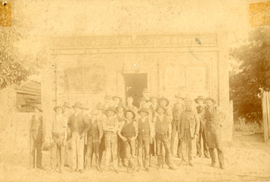 The Beechworth Burke Museum
Photograph, Farrell & Martin Landscape Photographers, c1900
This photograph shows a group of workmen standing outside the Ford Street office of the Ovens and Murray Advertiser in Beechworth. The Advertiser was a local paper, first printed as a weekly in 1855, and then as a daily in 1857. It continues to be printed today, albeit in a different form. The Advertiser was launched by architect Francis Hodgson Nixon with assistance from businessman John Henry Gray, and newspaperman Richard Warren. Warren was sole owner from 1860 until his death in 1906, and it responsible for much of the paper’s success. Its goals included coverage of local events, as well as of global news, and the promotion of economic liberty, arts, and sciences. Beyond these initial goals, the Advertiser was instrumental in local politics, particularly Beechworth’s association with conservatism and constitutionalism in the 1860s and 1870s. Numerous other papers sprung up to contest the Advertiser’s hold during the latter half of the nineteenth-century, but none were able to completely oust it from its post. As well as representing a key chapter in Beechworth’s history, the Advertiser can be used as a key source for the stories and figures of historic Beechworth. This photograph has historic significance for its relationship to the history of the Ovens and Murray Advertiser, which is a key example of of successful nineteenth-century business in Beechworth.Faded sepia rectangular photograph printed on photographic material, mounted on board. Obverse: The Owens and Murray Advertiser Reverse: Parkinson (crossed out) BMM 7725 15/ Failey/ [logo Farrell and Martin Landscape Photographers]ovens and murray advertiser, the ovens and murray advertiser, newspaper, printing, ford street, richard warren, journalism, advertising, 1800s, 1800s beechworth, #beechworth, local business, advertiser, workmen, hats, printers, journalists -
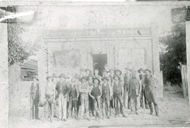 The Beechworth Burke Museum
Photograph
This photograph shows a group of workmen standing outside the Ford Street office of the Ovens and Murray Advertiser in Beechworth. The Advertiser was a local paper, first printed as a weekly in 1855, and then as a daily in 1857. It continues to be printed today, albeit in a different form. The Advertiser was launched by architect Francis Hodgson Nixon with assistance from businessman John Henry Gray, and newspaperman Richard Warren. Warren was sole owner from 1860 until his death in 1906, and it responsible for much of the paper’s success. Its goals included coverage of local events, as well as of global news, and the promotion of economic liberty, arts, and sciences. Beyond these initial goals, the Advertiser was instrumental in local politics, particularly Beechworth’s association with conservatism and constitutionalism in the 1860s and 1870s. Numerous other papers sprung up to contest the Advertiser’s hold during the latter half of the nineteenth-century, but none were able to completely oust it from its post. As well as representing a key chapter in Beechworth’s history, the Advertiser can be used as a key source for the stories and figures of historic Beechworth. This photograph has historic significance for its relationship to the history of the Ovens and Murray Advertiser, which is a key example of of successful nineteenth-century business in Beechworth.Black and white rectangular photo printed on paper, unmounted. Copy rather than original. Obverse: The Ovens and Murray Advertiser Inverse 2581 PH246 ovens and murray advertiser, the ovens and murray advertiser, newspaper, printing, ford street, richard warren, journalism, advertising, 1800s, 1800s beechworth, #beechworth, local business, advertiser, workmen, hats, printers, journalists -
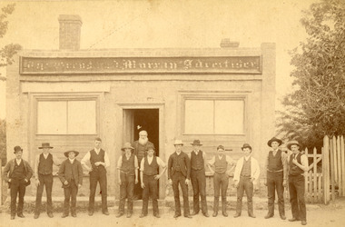 The Beechworth Burke Museum
Photograph, R & M Harvey
This photograph shows a group of men standing outside the Ford Street office of the Ovens and Murray Advertiser in Beechworth. This group includes the Advertiser''s manager, Richard Warren, who is bearded man standing in the doorway and who's name is written on the reverse of the photograph. The Advertiser was a local paper, first printed as a weekly in 1855, and then as a daily in 1857. It continues to be printed today, albeit in a different form. The Advertiser was launched by architect Francis Hodgson Nixon with assistance from businessman John Henry Gray, and newspaperman Richard Warren. Warren was sole owner from 1860 until his death in 1906, and it responsible for much of the paper’s success. Its goals included coverage of local events, as well as of global news, and the promotion of economic liberty, arts, and sciences. Beyond these initial goals, the Advertiser was instrumental in local politics, particularly Beechworth’s association with conservatism and constitutionalism in the 1860s and 1870s. Numerous other papers sprung up to contest the Advertiser’s hold during the latter half of the nineteenth-century, but none were able to completely oust it from its post. As well as representing a key chapter in Beechworth’s history, the Advertiser can be used as a key source for the stories and figures of historic Beechworth. As well as managing the Advertiser, Richard Warren's owned or managed multiple businesses in Beechworth, founded the Ovens hospital and Benevolent asylum, invested in local companies, and participated in a range of religious brotherhoods and societies. He married Mary Ann Mitchell when he was twenty-six, and, while the couple were unable to have children, they adopted one son, who began managing the Advertiser in the late-nineteenth century. This photograph has historic significance afor its relationship to the history of the Ovens and Murray Advertiser, which is a key example of of successful nineteenth-century business in Beechworth, and for including an image of Richard Warren, a key figure in the period. Sepia rectangular photograph, faded, printed on photographic material and mounted on board. Obverse: The Ovens and Murray Advertiser Reverse: Or M A/ Printing Office/ Ford Street About 1860/ Beechworth/ R Warren [logo: R & M Harvey/Authorised Newsagents/ and Gift Shop/ Beechworth Phone 114]ovens and murray advertiser, the ovens and murray advertiser, newspaper, printing, ford street, richard warren, journalism, advertising, 1800s, 1800s beechworth, #beechworth, local business, advertiser, workmen, hats, printers, journalists, warren, mary ann mitchell, mary ann warren, 1860s, 1860s beechworth, r warren, r & m harvey -
 The Beechworth Burke Museum
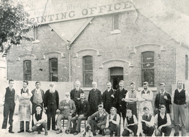
Photograph, c1900
This photograph shows a group of workmen outside the Loch Street Printing Office of the Ovens and Murray Advertiser in Beechworth. The Advertiser was a local paper, first printed as a weekly in 1855, and then as a daily in 1857. It continues to be printed today, albeit in a different form. Initially based on Ford Street, the Loch Street office opened in 1893, after printing facilities were updated. The Advertiser was launched by architect Francis Hodgson Nixon with assistance from businessman John Henry Gray, and newspaperman Richard Warren. Warren was sole owner from 1860 until his death in 1906, and it responsible for much of the paper’s success. He appears in this photo alongside twenty of his staff and is the man standing directly in front of the doorway. When it launched, the paper’s goals included coverage of local events, as well as of global news, and the promotion of economic liberty, arts, and sciences. Beyond these initial goals, the Advertiser was instrumental in local politics, particularly Beechworth’s association with conversates and constitutionalism in the 1860s and 1870s. Numerous other papers sprung up to contest the Advertiser’s hold during the latter half of the nineteenth-century, but none were able to completely oust it from its post. As well as representing a key chapter in Beechworth’s history, the Advertiser can be used as a key source for the stories and figures of historic Beechworth. As well as managing the Advertiser, Richard Warren's owned or managed multiple businesses in Beechworth, founded the Ovens hospital and Benevolent asylum, invested in local companies, and participated in a range of religious brotherhoods and societies. He married Mary Ann Mitchell when he was twenty-six, and, while the couple were unable to have children, they adopted one son, who began managing the Advertiser in the late-nineteenth century. This photograph has historic significance afor its relationship to the history of the Ovens and Murray Advertiser, which is a key example of of successful nineteenth-century business in Beechworth, and for including an image of Richard Warren, a key figure in the period.Rectangular black and white photo printed on photographic material, unmounted. Obverse: Ovens and Murray/ Printing Office Reverse: Ovens and Murray Advertiser Staff 7721/ Beechworth/ BMM 79.15ovens and murray advertiser, the ovens and murray advertiser, newspaper, printing, richard warren, journalism, advertising, 1800s, 1800s beechworth, #beechworth, local business, advertiser, workmen, hats, printers, journalists, warren, mary ann mitchell, mary ann warren, r warren, loch street, 1890s, 1890s beechworth -
 The Beechworth Burke Museum
Photograph, est. 1860-1875
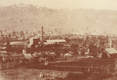
In 1875, the Rocky Mountain Extended Gold Sluicing Company Ltd was created, utilising the previous Rocky Mountain claim for the area near Lake Sambell. The company employed A.L Martin to survey an area for a tunnel underneath Beechworth and Johnson Stephens to dig it. The tunnel was built at a rate of 40 feet a month and eventually measured 800 metres. The tunnel was a true accomplishment both in the present and during the 19th century. It was considered to be a marvelous engineering feat. Beechworth is renowned for its hydraulic sluice method of mining. This involved soil being exposed to torrents of water from high-pressure hoses. From 1876 until its closure in 1921, the mine produced an astounding 47,926 ozs of gold. Companies like this were the source of income for many Chinese gold-diggers who sought to make their fortune on the goldfields of Beechworth. During the height of the rush, the town had around 7,000 Chinese inhabitants living on the outskirts of town as they were not permitted to live within Beechworth itself.The search for gold is ingrained into the history of Victoria and therefore, images like this one which portrays an open-cut sluicing site can reveal important information for society and technology for the date when the photograph was taken. This image is of important historical significance for its ability to convey information about sluicing and the methods used to find gold in 1910. It also shows a location where sluicing was undertaken which provides insight into the impact of sluicing on the environment at a time when it was done. This image of the Rocky Mountain mine is historically significant as the mining complex is now non-existent, with the only remains being the tunnel built in 1880 by the company, which was considered one of the greatest engineering feats of the time. The image also provides a first-hand look into the social and cultural networks at play during the 19th century with racial segregation of the Chinese at the 'Chinese Camp', as well as an insight into Beechworth's origins during the Gold Rush.A sepia rectangular photograph printed on matte photographic paper as a postcardReverse: Historic Beechworth / 7792.1 / ROCKY MOUNTAIN MINE / Viewed from the “Chinese Camp”, shown partly in the foreground, we see the central plant of the famous Rocky Mountain Mining Company. This extensive complex, of which nothing remains, was situated between Silver Creek and the present Lake Sambell area. The company was responsible for a tunnel cut through solid bedrock underneath the town of Beechworth and surfacing near the keystone bridge on the Wangaratta side. Completed in 1880 it was declared to be one of the greatest engineering feats in Australia. The tunnel is still basically intact today. / Series by Wooragee Graphics: Historic Beechworth. / COPYRIGHT BURKE MUSEUM / No.72 beechworth, rocky mountain mine, sluicing, gold rush, mining, gold -
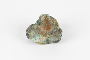
 The Beechworth Burke Museum
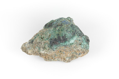
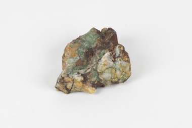
Geological specimen - Malachite, Unknown
Malachite is typically found as crystalline aggregates or crusts, often banded in appearance, like agates. It is also often found as botryoidal clusters of radiating crystals, and as mammillary aggregates as well. Single crystals and clusters of distinguishable crystals are uncommon, but when found they are typically acicular to prismatic. It is also frequently found as a pseudomorph after Azurite crystals, which are generally more tabular in shape. This particular specimen was recovered from the Burra Burra Copper Mine in Burra, South Australia. Otherwise known as the 'Monster Mine', the Burra Burra Copper Mine was first established in 1848 upon the discovery of copper deposits in 1845. Within a few short years, people from around the world migrated to Burra to lay their claim in the copper economy. By April 1848 the mine was employing over 567 people and supporting a population of 1,500 in the local township. Up until 1860, the mine was the largest metals mine in Australia, producing approximately 50,000 tonnes of copper between 1845 to its closure in 1877. The Burra Burra Mine was also famous for a number of other specimens, including; crystalline azurite, cuprite, and botryoidal and malachite. Malachite is considered a rare gemstone in that the original deposits for the stones have been depleted leaving behind very few sources. In addition, the use of Malachite as gemstones and sculptural materials remains just as popular today as they were throughout history. It is quite common to cut the stone into beads for jewellery. The fact that Malachite has such a rich colour and one that does not fade with time or when exposed to light makes it particularly rare. This specimen is part of a larger collection of geological and mineral specimens collected from around Australia (and some parts of the world) and donated to the Burke Museum between 1868-1880. A large percentage of these specimens were collected in Victoria as part of the Geological Survey of Victoria that begun in 1852 (in response to the Gold Rush) to study and map the geology of Victoria. Collecting geological specimens was an important part of mapping and understanding the scientific makeup of the earth. Many of these specimens were sent to research and collecting organisations across Australia, including the Burke Museum, to educate and encourage further study. A solid hand-sized copper carbonate hydroxide mineral with shades of blue and light green throughout. burke museum, beechworth, indigo shire, beechworth museum, geological, geological specimen, mineralogy, burra, burra burra mine, south australia, malachite, malachite specimen -
 The Beechworth Burke Museum
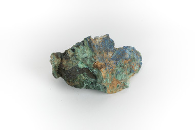
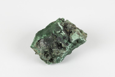
Geological specimen - Malachite, Unknown
Malachite is a green copper carbonate hydroxide mineral and was one of the first ores used to make copper metal. Malachite has been utilised as a gemstone and sculptural material in the past as its distinctive green color does not fade when exposed to light or after long periods of time. Malachite is formed at shallow depths in the ground, in the oxidizing zone above copper deposits. The material has also been used as a pigment for painting throughout history. This particular specimen was recovered from the Burra Burra Copper Mine in Burra, South Australia. Otherwise known as the 'Monster Mine', the Burra Burra Copper Mine was first established in 1848 upon the discovery of copper deposits in 1845. Within a few short years, people from around the world migrated to Burra to lay their claim in the copper economy. By April 1848 the mine was employing over 567 people and supporting a population of 1,500 in the local township. Up until 1860, the mine was the largest metals mine in Australia, producing approximately 50,000 tonnes of copper between 1845 to its closure in 1877. The Burra Burra Mine was also famous for a number of other specimens, including; crystalline azurite, cuprite, and botryoidal and malachite.Malachite is considered a rare gemstone in that the original deposits for the stones have been depleted leaving behind very few sources. In addition, the use of Malachite as gemstones and sculptural materials remains just as popular today as they were throughout history. It is quite common to cut the stone into beads for jewellery. The fact that Malachite has such a rich colour and one that does not fade with time or when exposed to light makes it particularly rare. This specimen is part of a larger collection of geological and mineral specimens collected from around Australia (and some parts of the world) and donated to the Burke Museum between 1868-1880. A large percentage of these specimens were collected in Victoria as part of the Geological Survey of Victoria that begun in 1852 (in response to the Gold Rush) to study and map the geology of Victoria. Collecting geological specimens was an important part of mapping and understanding the scientific makeup of the earth. Many of these specimens were sent to research and collecting organisations across Australia, including the Burke Museum, to educate and encourage further study. A solid hand-sized copper carbonate hydroxide mineral with shades of yellow, blue, and light green throughout.geological, geological specimen, burke museum, indigo shire, malachite, malachite specimen, burra burra mine, burra, south australia, australian mines, mines, monster mine -
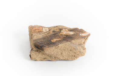 The Beechworth Burke Museum
Geological specimen - Yellow Sandstone
This specimen is from Barefoot Hills, Victoria. Sandstones are economically important as major reservoirs for both petroleum and water, as building materials, and as valuable sources of metallic ores. Most significantly, they are the single most useful sedimentary rock type for deciphering Earth history. This specimen is part of a larger collection of geological and mineral specimens collected from around Australia (and some parts of the world) and donated to the Burke Museum between 1868-1880. A large percentage of these specimens were collected in Victoria as part of the Geological Survey of Victoria that begun in 1852 (in response to the Gold Rush) to study and map the geology of Victoria. Collecting geological specimens was an important part of mapping and understanding the scientific makeup of the earth. Many of these specimens were sent to research and collecting organisations across Australia, including the Burke Museum, to educate and encourage further study.A sedimentary rock composed mostly of quartz sand. Sandstone is the second most common sedimentary rock after shale. Sandstones consist of sand-sized grains principally quartz, feldspar and rock fragments. The two major classes of sandstone are arenite and wacke. the colour of sandstone varies from grey, yellow, red and white reflecting the variation in mineral content and cement and is gritty to touch (like sandpaper).Geological survey / R.... S 61 / Loc Bareboot Hills / Sheet / 24SE / 94 /burke museum, beechworth, indigo shire, beechworth museum, geological, geological specimen, mineralogy, sandstone, yellow sandstone, victoria, barefoot hills -
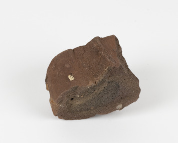 The Beechworth Burke Museum
Geological specimen - Ropy Lava
‘Ropy lava’ is known for its sculptural and layered qualities. It occurs in specific lava flows that are slow moving and slow cooling, allowing for unique formations to be created out of the motion. Ropy Lava is a flow that has a hardened crust with molten material underneath, the tension between these states is what creates its characteristic form. The brown/red hue of the stone is an indication of age, as it is oxidised iron deposits. This rock deposit is thought to be sourced from the area by Talbot, in western Victoria. This area has a rich mineral history and experienced the gold rush in the 1850's. The traditional owners of this area are the Dja Dja Wurrung people.This geological specimen shows the conditions in which the Australian landscape was created as well as provides an indication as to how these events occurred. It is representative of a common natural process that contextualises the formation of Australia with the formation of other landmasses. This specimen is part of a larger collection of geological and mineral specimens collected from around Australia (and some parts of the world) and donated to the Burke Museum between 1868-1880. A large percentage of these specimens were collected in Victoria as part of the Geological Survey of Victoria that begun in 1852 (in response to the Gold Rush) to study and map the geology of Victoria. Collecting geological specimens was an important part of mapping and understanding the scientific makeup of the earth. Many of these specimens were sent to research and collecting organisations across Australia, including the Burke Museum, to educate and encourage further study.Hand sized specimen in brown/red hues42 / victoria, talbot, lava, ropy, ropy lava, mineral, geological specimen, geological, geological heritage, natural stone, natural history -
 The Beechworth Burke Museum
Audio - Oral History, Jennifer Williams, Maxwell Pemberton, 23 June 2000
Mr Maxwell Pemberton was born in Goulburn, NSW in 1923 and moved to Beechworth as a child just before the Great Depression. Mr Pemberton's father was a baker who opened a grocery store in Beechworth to support his seven children. The store, which competed with eight other grocery traders in Beechworth for finite local business, delivered goods by horse and cart to customers all over the district, including the hamlet of Stanley. Mr Pemberton's oral history testifies to the sorts of economic struggles faced by the majority of Beechworth's residents during the depression years. Mr Pemberton worked in many different industries in and around Beechworth, including in his father's grocery store, which he later took over with his brother; the Zwar Tannery, where he served as a union representative; and at the Ovens and Murray Hospital for the Aged, formally the Ovens Benovolent Asylum, established in 1862 for care of the district's destitute, disabled and aged people from Euroa to the Murray, among them, homeless people Mr Pemberton referred to as 'river-bankers'. The hospital's founding in the 1860s was driven by a committee headed by the notable figure, G.B Kerford. Beechworth's institutions were a major source of local employment in the twentieth century. Mr Pemberton joined the Australian Navy during WWII and served at Port Moresby in Papua New Guinea. During his period of service, he received an honorary award from the Royal Humane Society of Australia for aiding and saving a drowning civilian at risk to his own life. Mr Pemberton's oral history also touches on the complex relationship between Australian forces and local Papuan people during the war. This oral history recording was part of a project conducted by Jennifer Williams in the year 2000 to capture the everyday life and struggles in Beechworth during the twentieth century. This project involved recording seventy oral histories on cassette tapes of local Beechworth residents which were then published in a book titled: Listen to what they say: voices of twentieth century Beechworth. These cassette tapes were digitised in July 2021 with funds made available by the Friends of the Burke.Mr Maxwell Pemberton's oral history recalls many aspects of life in Beechworth and the Oven's district during the twentieth century and enriches our understanding of the effects of the periods of socio-economic decline and renewal that unfolded as the century progressed. His singular account of his various jobs and colourful memories of life as a youth and young man in Beechworth, and abroad as a serviceman, contributes to our understanding of society's attitudes and expectations regarding ideals of masculinity and Australian national identity. This oral history account is socially and historically significant as it is a part of a broader collection of interviews conducted by Jennifer Williams which were published in the book 'Listen to what they say: voices of twentieth-century Beechworth.' While the township of Beechworth is known for its history as a gold rush town, these accounts provide a unique insight into the day-to-day life of the town's residents during the 20th century, many of which would have been lost if they had not been preserved.This is a digital copy of a recording that was originally captured on a cassette tape. The cassette tape is black with a horizontal white strip and is currently stored in a clear flat plastic rectangular container. It holds up 40 minutes of recordings on each side.Mr Max Pemberton /twentieth century beechworth, benevolent asylums, wwii, beechworth's institutions, local employment, government institutions, listen to what they say, oral history, burke museum, maxwell pemberton, ovens and murray hospital for the aged, zwar tannery, beechworth grocers, australian navy, port morseby, papua new guinea, trade unions, welfare services, homelessness, 'river bankers', aged care, g.b kerford, ovens benevolent asylum, ovens benevolent home -
The Beechworth Burke Museum
Audio - Oral History, Mrs May Harris, July 2000
This oral history interview was conducted with Mrs May Harris (née Peach), who grew up in the farming town of Stanley, about 9km southeast of Beechworth. Mrs Harris moved to Melbourne and got work cleaning houses before getting married. Her husband worked on farms, and the couple eventually found their way back to Stanley. She describes experiences of illness, particularly her husband and children's experience with asthma and the impact that had on their lives and careers. Mrs Harris talks about local fundraising events in Stanley, particularly what she calls 'Australian Teas', as well as some of the dances and picnics that were major sources of entertainment when she was young. This oral history recording was part of a project conducted by Jennifer Williams in the year 2000 to capture the everyday life and struggles in Beechworth during the twentieth century. This project involved recording seventy oral histories on cassette tapes of local Beechworth residents which were then published in a book titled: Listen to what they say: voices of twentieth century Beechworth. These cassette tapes were digitised in July 2021 with funds made available by the Friends of the Burke.Mrs May Harris' statement explores life in a small farming community alongside some of her life in the city, which might provide an interesting comparison. She discusses the difficulties of facing illnesses in these rural communities, noting the lack of available resources and need to travel to Beechworth. She discusses community events, highlighting both the social aspects and the fundraising aspects.This is a digital copy of a recording that was originally captured on a cassette tape. The cassette tape is black with a horizontal white strip and is currently stored in a clear flat plastic rectangular container. It holds up 40 minutes of recordings on each side.listen to what they say, beechworth, oral history, burke museum, illness, asthma, farming, farm work, rural life, stanley, stanley athenaeum, sinclair's sawmill, sawmill, the great depression, housework, australian tea, fundraising -
 The Beechworth Burke Museum
Geological specimen - Malachite, unknown
Malachite is a water soluble, crystalline, triphenyl methylene chloride salt. It has a close relationship to copper because it is common for Malachite and copper to come from the same ore. Malachite often has shades of green, making it also known as Malachite Green. As a result of it's colour, it is known for being a dye and has been used in the dye industry, the textile industry and in medical fields. Cobar in New South Wales is well known for it's mining. This is because of the number of important deposits present in the area and include three important mining belts where most of the materials are found. These are the 'Cobar belt', the 'Canbelego belt' and the 'Girilambone belt'. The 'Cobar belt' runs underneath the main town. Copper was first discovered in Cobar in 1869 and since then, many deposits of other materials have been found, including Malachite.This specimen is significant because it comes from Cobar, NSW and represents the many deposits of materials found there. Cobar has a long history of mining and is a source of Australia's copper minerals. Malachite is often found in copper deposits meaning that it is representative of Cobar's copper production. Malachite is known for it's vivid green colour and as a result, has many uses, such as meaning used as a dye. This makes it a valuable material and highly significant. This specimen is part of a larger collection of geological and mineral specimens collected from around Australia (and some parts of the world) and donated to the Burke Museum between 1868-1880. A large percentage of these specimens were collected in Victoria as part of the Geological Survey of Victoria that begun in 1852 (in response to the Gold Rush) to study and map the geology of Victoria. Collecting geological specimens was an important part of mapping and understanding the scientific makeup of the earth. Many of these specimens were sent to research and collecting organisations across Australia, including the Burke Museum, to educate and encourage further study.A solid hand-sized mineral with shades of brown , white and light green throughout.geological specimen, geology, geology collection, burke museum, beechworth, malachite, copper, water soluble, cobar, cobar mines, cobar mining, cobar nsw, nsw, new south wales, mining belts, ore, copper ore, malachite green, dye, green, dye industry, textile industry, desposits, canbelego, girilambone, alfred selwyn -
 The Beechworth Burke Museum
Geological specimen - Malachite in Conglomerate, Unknown
Malachite is a green copper carbonate hydroxide mineral and was one of the first ores used to make copper metal. Malachite has been utilised as a gemstone and sculptural material in the past as its distinctive green color does not fade when exposed to light or after long periods of time. Malachite is formed at shallow depths in the ground, in the oxidizing zone above copper deposits. The material has also been used as a pigment for painting throughout history. Malachite is considered a rare gemstone in that the original deposits for the stones have been depleted leaving behind very few sources. In addition, the use of Malachite as gemstones and sculptural materials remains just as popular today as they were throughout history. It is quite common to cut the stone into beads for jewellery. The fact that Malachite has such a rich colour and one that does not fade with time or when exposed to light makes it particularly rare. Although there is no indication available of the locality from which the specimen was sourced, it is likely that the specimen was collected either in South Australia in the vicinity of the Burra Burra mines or in Victoria as part of programs of geological surveying undertaken in the Nineteenth and Twentieth centuries. This specimen is part of a larger collection of geological and mineral specimens collected from around Australia (and some parts of the world) and donated to the Burke Museum between 1868-1880. A large percentage of these specimens were collected in Victoria as part of the Geological Survey of Victoria that begun in 1852 (in response to the Gold Rush) to study and map the geology of Victoria. Collecting geological specimens was an important part of mapping and understanding the scientific makeup of the earth. Many of these specimens were sent to research and collecting organisations across Australia, including the Burke Museum, to educate and encourage further study.A solid hand-sized copper carbonate hydroxide mineral with quartz pebbles in red conglomorate matrix presenting shades of cream, brown and green.Existing label: Malachite / (green) in / conglomerate / (white quartz / pebbles / in red matrix /geological specimen, geology, geology collection, burke museum, beechworth, geological, indigo shire, malachite, malachite specimen, australian mines, mines, geological survey, conglomorate, matrix -
 The Beechworth Burke Museum
Geological specimen - Greenstone, Hokitika Jade Company, unknown
New Zealand Greenstone, also called Pounamu is found on New Zealand’s South Island in riverbeds and boulders, and colours vary depending on the source, but always include green tones. It is a form of the mineral nephrite, also known as jade, and is a tough stone with a crystalline structure, made up of calcium magnesium and iron silicate. Its hardness means it is ideal for carving, and has been used for this purpose throughout history, especially by the Maori people of New Zealand. Greenstone features heavily in Maori mythology, and the traditional name for the South Island, Te-Wai-Pounamu, literally translates to waters of greenstone. Wearing of Greenstone pendants with different carvings is practiced by Maori to represent connection to land and ancestors, or to endow the wearer with certain attributes. The sticker on the base of the specimen identifies it as a product of Hokitika Jade Company. The company, which was active in the 1970s, sold jade and greenstone specimens and ornaments. Hokitika, which started life as an 1860s gold rush town, is the origin of most nephrite found in New Zealand, and the centre of the Greenstone carving industry. The object has scientific and research potential as part of the Burke Museum's Geology Collection, and as and example of New Zealand Greenstone. It also has spiritual significance for it's role in Maori beliefs and communities, where it is both traditionally worn and features in mythology. As a valuable stone regularly used in carving and jewellery, it has aesthetic significance. Sticker on base: "N.Z. Greenstone/ a product of/ Hokitika Jade Coy."geological specimen, geology, geology collection, burke museum, beechworth, new zealand, greenstone, hokitika, nephrite, jade -
 The Beechworth Burke Museum
Geological specimen - Malachite, Unknown
Malachite is a copper carbonate hydroxide mineral. It has a chemical composition of Cu2(CO3)(OH)2. It often forms within limestone where a subsurface chemical environment favourable for the formation of carbonate minerals can occur. It is a substance that can be found in many different parts of the world including: Australia, USA, Russia and the Democratic Republic of Congo. Malachite has historically been used to produce copper, with mining of the mineral dating back over a period of four thousand years. Due to its beautiful green colourations, it is also commonly used for aesthetic purposes such as in the production of sculptures and jewellery. This particular specimen was collected from the town of Burra, South Australia as part of a geological survey undertaken during the nineteenth century. The locality (located on Ngadjuri Country) has a long history of mining, particularly in copper mining, as the area is rich in copper deposits. The first significant discovery of this was made in Burra (Burra Burra Mine) in 1845 and, at the time, the mine was the largest and richest of its kind in the world, producing nearly five percent of the total world copper output. This specimen is significant as it is considered to be a rare gemstone, as many of the original deposits for the stones are significantly depleted, leaving behind very few sources. This specimen is part of a larger collection of geological and mineral specimens collected from around Australia (and some parts of the world) and donated to the Burke Museum between 1868-1880. A large percentage of these specimens were collected in Victoria as part of the Geological Survey of Victoria that begun in 1852 (in response to the Gold Rush) to study and map the geology of Victoria. Collecting geological specimens was an important part of mapping and understanding the scientific makeup of the earth. Many of these specimens were sent to research and collecting organisations across Australia, including the Burke Museum, to educate and encourage further study.A solid palm-sized copper carbonate hydroxide mineral with patterns of green colourations Existing Label: MALACHITE / Locality: Burra / S. Aust. Other Label: Confirmed / as Malachite / C. Willman / 15/4/1 / + Bill Birch burke museum, beechworth, geological, geological specimen, malachite, gemstone, green gemstone, burra, burra burra mine, burra south australia, carbonate mineral, copper, copper mining, copper mining burra, carbonate hydroxide mineral, copper carbonate, malachite mining, malachite burra, monster mine -
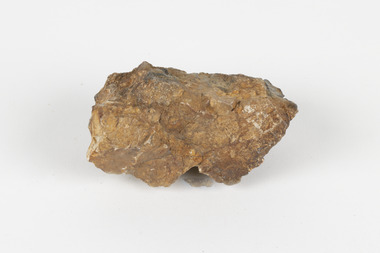 The Beechworth Burke Museum
Geological specimen - Cassiterite
This specimen is Cassiterite in Quartz. Cassiterite is a tin oxide metal that forms in thin crystals which can have a beautiful lustre. Quartz is made of silicon dioxide, also known as silica, and is one of the most common minerals on earth. Cassiterite has been a fundamental source of tin ore for humans throughout history, including today. Tin is an important metal that has a wide variety of human uses in different areas, from dying fabric, to making mirrors, and their most well-known use ‘tin’ cans. Tin cans are primarily made of steel and are coated with tin in order to take advantage of tin’s property of being non-corroding. This is a massive step in the history of food preservation. Tinned food first reached Australia in 1815 with early settlers, and it began to be manufactured here in the 1840s. It was incredibly popular, and was a highly exported product, which would be a contributing factor to the ‘tin mining boom’ of the early 1880s. This specimen was collected at Jingellic, New South Wales, in about 1852. Although the Goldfields of the 1800s are much more well-known, tin mines existed alongside the gold mines which began in the mid 19th century and extended almost one hundred years, to the mid 20th century. Specimens like this would have been used as evidence to justify tin mining operations in the region as an investment. This specimen is part of a larger collection of geological and mineral specimens collected from around Australia (and some parts of the world) and donated to the Burke Museum between 1868-1880. A large percentage of these specimens were collected in Victoria as part of the Geological Survey of Victoria that begun in 1852 (in response to the Gold Rush) to study and map the geology of Victoria. Collecting geological specimens was an important part of mapping and understanding the scientific makeup of the earth. Many of these specimens were sent to research and collecting organisations across Australia, including the Burke Museum, to educate and encourage further study. The Geological Survey of Victoria was headed by British geologist, Alfred Richard Cecil Selwyn (1824-1902), who was responsible for issuing over 60 geological maps during his 17 years as director. These maps were all hand-drawn and coloured and became the benchmark for accuracy for geological mapping. Collecting geological specimens was an important part of mapping and understanding the scientific makeup of the earth. Many of these specimens were sent to research and collecting organisations across Australia, including the Burke Museum, to educate and encourage further study. A fist-sized solid geological specimen made on one half of tin oxide, which is dark grey, and on the other side of silica, which is brown and cream.burke museum, beechworth, geological, geological specimen