Showing 924 items matching "land subdivisions"
-
 Ringwood and District Historical Society
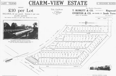
Photograph, Land sale advertisement for Charm View Estate, Heathmont - 1927
... Typed below photograph, "From 1927 land subdivision... 1927 land subdivision brochure". Map - Charm-View Estate Land ...Map - Charm-View EstateTyped below photograph, "From 1927 land subdivision brochure". -
 Whitehorse Historical Society Inc.
Newspaper - Article, Residents fear for streetscape, 28/09/1994
... Land Subdivision...,' (Walker home), Meerut Street, Mitcham, land subdivision opposite.... Australian Tesselated Tile Co Pty Ltd Barelli Ken Land Subdivision ...'Residents fear for streetscape' ' Mitcham Mansion,' (Walker home), Meerut Street, Mitcham, land subdivision opposite.meerut street, mitcham, walker, edgar edwardes, australian tesselated tile co pty ltd, barelli, ken, land subdivision -
 Ringwood and District Historical Society
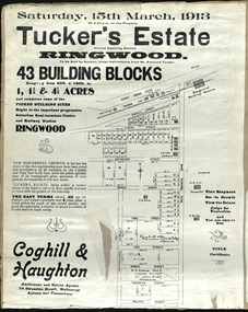
Card - Land Subdivision Clipping, Tucker's Estate, Ringwood, Vic. - 1913
... Land Subdivision Clipping...Partially trimmed copy of a land subdivision auction... Street, Melbourne. Partially trimmed copy of a land subdivision ...Partially trimmed copy of a land subdivision auction advertisement on cardboard backing, with digitised copy of original flyer.Subdivision includes Thanet Street, Albert Street, Arlington Street, Barkly Street, Maidstone Street, Kirk Street, Vine Street, Surrey Street, Yarmouth Street and West Prussia Road (later Wantirna Road) Ringwood, Vic. Property names include Wandsworth, Ingleside, Lyndhurst and Karsruhe. Auctioneer and Estate Agents - Coghill & Haughton, 79 Swanston Street, Melbourne Auburn and Canterbury. Licensed Surveyor - W.P. Steane, M.C.E., 317 Collins Street, Melbourne. -
 Whitehorse Historical Society Inc.
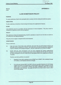
Document, Land Subdivision Policy, 24/08/1998 12:00:00 AM
... Land Subdivision Policy...land subdivision...Land subdivision policy: approved by City... Mitcham melbourne A4 2p land subdivision city of whitehorse Land ...Land subdivision policyLand subdivision policy: approved by City of Whitehorse.Ordinary council meeting 24/8/1998, Item 12.1.5 p. 42-43Land subdivision policyland subdivision, city of whitehorse -
 Whitehorse Historical Society Inc.
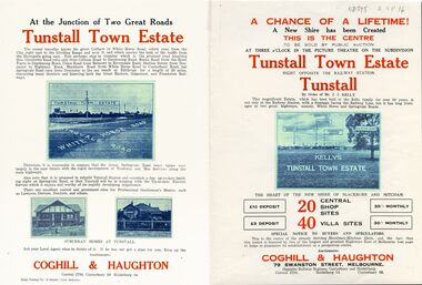
Legal record - Document, Tunstall Town Estate
... land subdivision...Land subdivision at Tunstall 1926 bounded by Springvale... Mitcham melbourne land subdivision springvale road nunawading ...Land subdivision at Tunstall 1926 bounded by Springvale Road, Whitehorse Road, Railway Parade.Land subdivision at Tunstall 1926 bounded by Springvale Road, Whitehorse Road, Railway Parade. Original in Haughton Maps LaTrobe LibraryLand subdivision at Tunstall 1926 bounded by Springvale Road, Whitehorse Road, Railway Parade. land subdivision, springvale road, nunawading, railway parade, kelly, j, nunawading state school, no. 4190, shire of blackburn and mitcham, whitehorse road, silver grove, glendale street -
Whitehorse Historical Society Inc.
Document, Land Subdivision, cnr Springvale and Burwood Roads, n.d
... Land Subdivision, cnr Springvale and Burwood Roads...Hand drawn document of land subdivision, Springvale Road... subdivision, Hand drawn document of land subdivision, Springvale Road ...Hand drawn document of land subdivision,Hand drawn document of land subdivision, Springvale Road & Burwood Road, together with notes of various sales from 1857 to 1957.Hand drawn document of land subdivision, burwood road, vermont south, springvale road, vermont south, stanley road, vermont south, vermont south, mayne, alexander, mayne, james alexander, craig, silas gordon, fankhauser, frederick william, fankhauser, mervyn william, burrell, charles, donaldson, john -
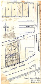 Ringwood and District Historical Society
Map, Partially trimmed copy of a retail and residential auction advertisement, Ringwood, Vic. - 1926
... One of 3 unrelated land subdivision maps on cardboard... unrelated land subdivision maps on cardboard backing. Numbered ...One of 3 unrelated land subdivision maps on cardboard backing. Numbered allotments on Nelson Street, Seymour Street and Whitehorse Road, Ringwood.W.J. Bonwick, Licensed Surveyor, Phone WU4830. Location map also includes Bourke Street, Bond Street, Charter Street, Ringwood Street, and Shops and Market sites in Ringwood. -
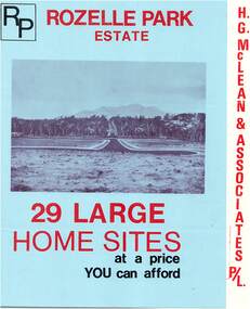 Ringwood and District Historical Society
Flyer, Subdivisional Land Sale Brochure, Rozelle Park Estate, Ringwood East, Vic. - circa 1968
... Folded land subdivision sale advertisement for 29 home...Subdivision includes Wingate Avenue and Rozelle Avenue ...Folded land subdivision sale advertisement for 29 home sites, with location map and summary of local facilities and services. Separate price list leaflet enclosed with terms of sale.Subdivision includes Wingate Avenue and Rozelle Avenue, Ringwood East. Agent - H.G. McLean & Associates Pty. Ltd., 166 Canterbury Road, Heathmont. Phone 870 3422 A/H 870 5879. -
 Ballan Shire Historical Society
Map - Map. Korweinguboora, Department of Lands and Survey, Korweinguboora. Counties of Talbot and Grant
... A map of the Korweinguboora area showing land subdivisions... of the Korweinguboora area showing land subdivisions and names of owners ...A map of the Korweinguboora area showing roads, forests, railway lines and properties with the owners names.The inclusion of the names of landowners is of significance and value to historians.A map of the Korweinguboora area showing land subdivisions and names of owners and other physical features. There is a scale in chains. No date is certain but it could be 1902. The map has been repaired with sellotape.There are various pencil annotations but the are difficult to read.talbot, moorarbool west, wombat, bullarto, korweinguboora, moorarbool east, dean, wombat state forest, barkstead -
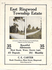 Ringwood and District Historical Society
Flyer, Subdivisional Land Sale Brochure, East Ringwood Township Estate, Vic. - 1923
... Bi-folded double sided land subdivision sale advertisement...-folded double sided land subdivision sale advertisement ...Bi-folded double sided land subdivision sale advertisement with location map and summary of local facilities and services. Includes two additional images of allotment plan with subsequent handwritten notations.Subdivision includes Mount Dandenong Road, Grey Street, and Eastfield Road. Agent - C.E. Carter, Bank Chambers, Main Street, Ringwood. Phone Ringwood 24. -
 Ballan Shire Historical Society
Map - Map. Shire of Ballan, Shire of Ballan
... and land subdivisions. It appears to be a copy of the original..., towns, settlements, State parks and forests and land ...This is a fairly comprehensive map of the former Shire of Ballan which is now amalgamated into the Shire of Moorabool.A black and white map of the Shire of Ballan showing major roads, rivers, towns, settlements, State parks and forests and land subdivisions. It appears to be a copy of the original as no dates or maker or printer appear on the map. There is a scale of 2 miles to 1 inch.gordon, ballan, bungal, kerrit bareet, borhoneyghurk, bungeeltap, ballark, yaloak, gorong, beremboke, wallace, ingliston, hunterston, millbrook, bradshaw, myrniong, blackwood, moorarbool, greendale, bayup, trentham, bullarto, korweinguboora, glenlyon, bolwarra -
Glen Eira Historical Society
Article - Rosstown Railway
... Land Development and Subdivisions... RETURN TO ROSSTOWN Beet Sugar Industry Crops Land Booms Land ...This file contains three items: 1/A review of the ROSSTOWN RAIL TRAIL from LIVING IN GLEN EIRA, vol. 11, 2004, Issue 4, no. 25, date and author unknown. The review explains the purpose of the Rail Trail with a brief narrative of the history behind Rosstown Sugar Mill Railway line. Concluding with information on the location of the Trail and the expected time required to walk the entire track included in the review is a map of the Rail Trail, which marks significant sites along the trail with historic pictures. 2/A newspaper article from THE AGE, dated Tuesday 21/10/1980 and written by Iola Matthews, reporting on the circumstances that led to the publication of the book RETURN TO ROSSTOWN written by Des Jowett and Ian Weickhardt. The article begins with a brief biography of the authors before moving into details of the book’s content, providing a further biography of W. Murray Ross which includes information on his financial ventures – particularly the Rosstown Rail – his marriage and children. The article includes a black and white photograph of Weickhardt and Jowett walking along the route of the railway line, an illustration of the Rosstown sugar works and a map of the area surrounding the site of the mill. 3/Three photocopies of a black and white illustration of the Rosstown sugar works from the east, undated and artist unknown.rosstown rail trail, rosstown, ross william, ross w. murray, ross murray, sugar beet mills, mills, elsternwick, land transport, railways, railway lines, railway routes, carnegie neville street, carnegie miller street, factories, market gardens, horticulture, peat, soils, land forms, topography, geology, civic issues, cone sugar industry, elsternwick plaza, elsternwick, glenhuntly road, parks and reserves, ee gunn reserve, caulfield racecourse, sportsgrounds, caulfield, carnegie, riddell parade, clarence street, aileen avenue, princes park, dover street, marara road, oakleigh road, rosanna street, murrumbeena crescent, north road, kooyong road, hawthorn road, booran road, koornang road, poath road, warragul road, railway platforms, railway buildings, bambra road, swamps, landforms, landfill, council landfill, railway bridges, bridges, railway underpasses, sporting clubs, tennis clubs, bowls clubs, rosstown railway, rosanna street reserve, maps, railway maps, living in glen eira, weickhardt ian, jowett des, caulfield south, curraweena road, oakleigh, caulfield technical school, return to rosstown, beet sugar industry, crops, land booms, land development and subdivisions, bent thomas, fink benjamin, sugar works, rosstown hotel, oamdenong road, rosstown dry cleaners, shops, rosstown road, rosstown plate, people by circumstance, migrants, accountants, occupations, professionals, the grange, real estate, grange road, financial agents, judges, rosstown estate, financial trouble, rabbit preserving, breweries, political debates, political issues, political electorates, politics, political science, debt, financial loans, court procedures, court cases, legal events and activities, malleson and riggall, widowers, seabeach railway, economics, economic deadline, depression 1890s, economic crash, mortgages, divorce, social problems, poverty, ross claude, ross roderick, world war 1914-1918, wars, military history, servicemen, australian flying corps, engineers, caulfield council, swagmen, homelessness, glenhuntly road, glenhuntly road tram, woornack road, leila road, wild cherry road, melten avenue, illustrations, steam trains, trains, horse and cart, horse-drawn transport, railway stations -
 Glen Eira Historical Society
Document - Thomas, George
... Land subdivision... Land subdivision Land sales Land prices Land development Land ...This file contains three items Hand written report on property of George Thomas in Orrong Road, dated 04/06/1985, author unknown Photocopy of four page contract and conditions of sale for lot 262 county of Burke Parish of Prahran. George Thomas property was sold to George William Taylor, dated 20/10/1881 The original photograph of a water colour painting of home and garden of George Thomas, Orrong Road, Caulfield by W. Tibbits 1876thomas eric f, thomas george, beemery park, orrong road, seymour road, allison road, mullaly j, j. fulton, taylor george william, warrein road, north road, stone adelaide, orrong road t. fulton, business, farmers, farm workers, farms, gardeners, subdivisions, land subdivision, land sales, land prices, land development, land developers -
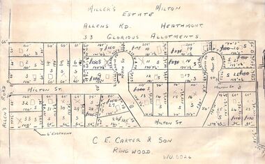 Ringwood and District Historical Society
Pamphlet - Land Sales Brochure, Miller's Estate , Heathmont - circa 1950s
... Hand-drawn land subdivision map with 33 allotments...LP28038 P/R 1954 Hand-drawn land subdivision map with 33 ...Hand-drawn land subdivision map with 33 allotments of the Miller's Estate on Allens Road, Milton Street, Heath Court and Mont Court, Heathmont. Sold by CE Carter & Son, Ringwood WU6024. (2 copies, one on blue cardboard backing.)LP28038 P/R 1954 -
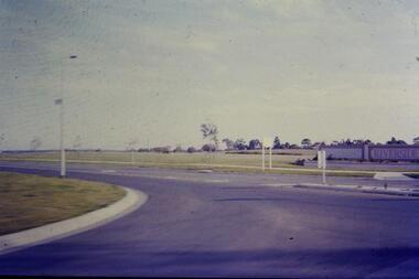 Greensborough Historical Society
Slide - Photograph, John Ramsdale, Riverside: Slide 1, 1990s
... Photograph shows a new land subdivision, with the name... Plenty Lower Plenty melbourne Photograph shows a new land ...Photograph shows a new land subdivision, with the name "Riverside" on a wall.Part of the John Ramsdale collection of slides and audio visual material.Colour photograph scanned from slide.No maker's marks or captions -
Canterbury History Group
Map - Canterbury Subdivisions
... and dates of land subdivision in Canterbury and surrounding suburbs.... and dates of land subdivision in Canterbury and surrounding suburbs ...A collection of 6 maps with notations showing the names and dates of land subdivision in Canterbury and surrounding suburbs.canterbury, logans estate, shrublands estate, claremount park estate, arklow hill estate, griffin estate, monomeath estate, mont albert park estate, great railway estate, grange estate -
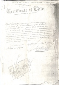 Whitehorse Historical Society Inc.
Document - Land Title, Certificate of Title, 29/11/1887
... land subdivision...Photocopies of land titles involved in subdivision of land... george henry mitcham primary school no. 2904 land subdivision ...Photocopies of land titles involved in subdivision of land on the north-west corner of Whitehorse Road and Mitcham Road including Britannia Street. A list of purchasers is included.mitcham road, mitcham, whitehorse road, britannia street, rawlings, alfred, frost, john, richards, thomas, leech, george arthur, smith, reed, richard louis, young, frederick, hughes, doery, george henry, mitcham primary school, no. 2904, land subdivision -
Ringwood and District Historical Society
Memoirs, McKellar, Margaret et al, Text of talk to Ringwood Historical Society by Margaret and Ian McKellar - history of "Reaghill" and Davies Family. 2005, 24-Sep-05
... The two articles give the history of the land subdivisions... of the land subdivisions over the years, of "Reaghill", a house owned ...The two articles give the history of the land subdivisions over the years, of "Reaghill", a house owned by the Davies family. The history of the land and family was given in a talk to Ringwood Historical Society by the McKellars in 2005.9 type-written pages. Pages 1-4 talk given by Margaret and Ian McKellar to the Ringwood Historical Society and a map. Pages 5-9 history of Reaghill and the Davies Family. +Additional Keywords: McKellar, Margaret / McKellar, Ian / Davies, George / Davies, Dora -
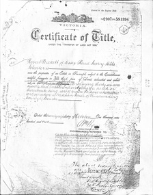 Whitehorse Historical Society Inc.
Document - Land Title, Certificate of Title, 28/10/1902
... land subdivision... by Robert Becket. Transfers of land through subdivision... samuel land subdivision Certificate of Title for land between ...Certificate of Title for land between Ormond Avenue, Fellows Street, Victoria Avenue and Mitcham Road, Mitcham owned by Robert Becket. Transfers of land through subdivision are included.whitehorse road, mitcham, mitcham road, ormond avenue, victoria avenue, gillies street, deakin street, fellows street, haines street, purches street, albert street, edward street, britannia street, beckett, robert, johnson, catherine, bewley, william, londgerin, mary, chugg, william harold, wheeler, sarah, byrne, bedson, samuel, land subdivision -
Whitehorse Historical Society Inc.
Document, Canterbury Road estate, Unknown
... land subdivision...Plan of subdivision of land for sale in Canterbury Road... Mitcham melbourne land subdivision canterbury road estate ...Plan of subdivision of land for sale in Canterbury Road estate, Blackburn.land subdivision, canterbury road estate, blackburn, main street, norvel street, kalka street, arna street, lalwa street, ronley street, eustace street -
 Surrey Hills Historical Society Collection
Photograph, 101 Guildford Road, Surrey Hills
... development of housing on the first urban land subdivision in Surrey... to encourage development of housing on the first urban land subdivision ...The house was built in 1883, possibly to encourage development of housing on the first urban land subdivision in Surrey Hills, the Windsor Park Estate (in the Windsor Crescent area). This coincided with the opening of the Surrey Hills Railway station. The first occupant was John Brown Nicholson, police magistrate. In 1884 the foundation meeting of the Wyclif Congregational Church was held in the house.Colour photo of the front door and verandah of 101 Guildford Road taken from the street. The house is Victorian in style with ornate lacework along the verandah. It is painted white and has a slate roof. There is a well-maintained garden with flower beds and shrubs, which partially obscure the house.victorian style, wyclif church, houses, guildford road, john brown nicholson -
Whitehorse Historical Society Inc.
Legal record - Land Title, Certificate of Title, 19/06/1911
... Certificate of Title of land at Lot 6 Subdivision 404.... Certificate of Title of land at Lot 6 Subdivision 404 Blackburn ...Certificate of Title of land at Lot 6 Subdivision 404 Blackburn on Whitehorse Road.Certificate of Title of land at Lot 6 Subdivision 404 Blackburn on Whitehorse Road.Certificate of Title of land at Lot 6 Subdivision 404 Blackburn on Whitehorse Road.goodwin, william, whitehorse road, blackburn, williams road, blackburn, certificates -
 Kew Historical Society Inc
Book, Plan of General Development, Melbourne : Report of the Metropolitan Town Planning Commission
... Housing and Land Subdivision Part VIII Civic Art and Amenities... Part VI Public Utilities Part VII Housing and Land Subdivision ...The 1929 report of the Metropolitan Town Planning Commission covering Melbourne and its suburbs. Includes photographs and 15 folding maps (some in rear pocket) This was a planning scheme to prevent 'misuse' of land and protect property values. It highlighted traffic congestion, the distribution of recreational open space and haphazard intermingling of land uses. The plan identified a number of problems, such as the congestion at St Kilda Junction, that were not addressed until decades later. The plan also recognised the value of Melbourne's waterways as an open space network.xii, 308 p., [25] leaves of plates (24 folded) : ill., maps (some col.), ports., plans ; 34 cm. CONTENTS Part 1 Surveys and studies Part II Communications Part III The execution of improvement schemes - a programme of urgent works Part IV Zoning Part V Public Recreation Part VI Public Utilities Part VII Housing and Land Subdivision Part VIII Civic Art and Amenities Part IX Miscellaneous Part X Legislation Part XI Conclusionnon-fictionThe 1929 report of the Metropolitan Town Planning Commission covering Melbourne and its suburbs. Includes photographs and 15 folding maps (some in rear pocket) This was a planning scheme to prevent 'misuse' of land and protect property values. It highlighted traffic congestion, the distribution of recreational open space and haphazard intermingling of land uses. The plan identified a number of problems, such as the congestion at St Kilda Junction, that were not addressed until decades later. The plan also recognised the value of Melbourne's waterways as an open space network.city planning -- victoria. -- maps, city planning -- victoria -- melbourne, city planning -- victoria, civic improvement -- victoria -- melbourne, melbourne -- (vic.), cartography -
Whitehorse Historical Society Inc.
Article, Too many industries, 1990
... Land subdivision...Article about subdivision of land of Wunderlich Monier... Mitcham melbourne Land subdivision Mitcham Road Vermont Rooks Road ...Article about subdivision of land of Wunderlich Monier, showing that this would increase the number of industries in the area.Article about subdivision of land of Wunderlich Monier, showing that this would increase the number of industries in the area.Article about subdivision of land of Wunderlich Monier, showing that this would increase the number of industries in the area.land subdivision, mitcham road vermont, rooks road vermont, wunderlich limited -
 Ringwood and District Historical Society
Document - Correspondence, REIV Proposal - History of Land Subidivision in Melbourne 1880-1960
... to commission a history of land subdivisions around Melbourne from circa..., with attachment: Proposal for The REIV to commission a history of land ...Email from Marie Wallington via Richard Carter (Carter Real Estate, Ringwood, Victoria) to G. Bruno (Real Estate Institute of Victoria), 31 October, 2008, with attachment: Proposal for The REIV to commission a history of land subdivisions around Melbourne from circa 1890s to circa 1960s. Subsequent Report to Past Presidents' Council dated 10th March 2009 including submission of proposed printing costs by Bounce Books, Rosanna, Victoria. Email from Allan Lord sent Monday, 4 April 2011 to Richard Carter, Subject: Wednesday Meeting, with list of names (for discussion?). -
Glen Eira Historical Society
Letter - Hopetoun, Hopetoun Street, 2, Elsternwick
... and architectural features and outlines possibilities for land subdivision... and architectural features and outlines possibilities for land subdivision ...A copy of a one page typed letter, from C J and T Ham of the Central Land Office to Florence M Cordner, dated 29/04/1904, providing a valuation of her property located at the corner of Glen Huntly Road and Hopetoun Street, Elsternwick. The valuation provides a description of the land, house improvements and architectural features and outlines possibilities for land subdivision. Noted on the document in pencil is 'From collection of Brighton Historical Society'.cordner florence mrs, glen huntly road, glenhuntly road, elsternwick, hopetoun street, moynsha, melrose, campbell a l, towers, verandahs, brick, stables, ham c j, ham t, c j & t ham, central land office, mansions -
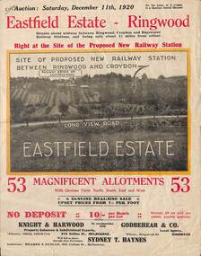 Ringwood and District Historical Society
Flyer, Subdivisional Land Auction Sale Brochure, Eastfield Estate, Ringwood, Vic. - 1920
... Bi-folded double sided land advertisement for subdivision...-folded double sided land advertisement for subdivision auction ...Bi-folded double sided land advertisement for subdivision auction on Saturday, December 11th, 1920, for Eastfield Estate with location map and summary of local facilities and services.Subdivision includes Croydon South streets - Eastfield Road, Long View Road, The Mount, and Pleasant Rise. Local Agent - Godbehear & Co, Phone Ringwood 49. -
Glen Eira Historical Society
Article - Shoobra Road, 52, Elsternwick, 'Wee Nestie'
... Land subdivision... gives a brief history of land subdivision and local tenants... Shoobra Road. Document gives a brief history of land subdivision ...Four items about this property: One typed document and its handwritten document of working notes on 52 Shoobra Road. Document gives a brief history of land subdivision and local tenants and owners of number 52 Shoobra Road by Brighton Historical Society One typed letter to J Atkin form Brighton Historical Society One photocopied typed letter to Rosalind Landells from Jenni Atkin dated 24/05/1993 Domain.com.au advertisement giving details for upcoming auction of the property on 08/09/2013. Includes 4 photographs of property.riddell john carre, pioneers, elsternwick, cavers carre, caulfield, hamilton thomas ferrier jp, land subdivision, hamilton street, shoobra road, wee nestie, ettrick, deeside, cerutty peter, cerutty lem mrs, kirby charles p, kirby charles f, landells rosalind, bullock hilary, atkin jenni mrs, house names, timber houses, edwardian style, noel jones real estate, brukarz jack, real estate agents, ashton daniel, stavrakis bill, lead lights, verandahs -
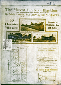 Whitehorse Historical Society Inc.
Document, Mascot Estate Blackburn
... land subdivision...Subdivision of land surrounded by Whitehorse Road, Simla... Mitcham melbourne land subdivision mascot estate blackburn ...Subdivision of landSubdivision of land surrounded by Whitehorse Road, Simla street and King Street. 50 villa sites auctioned by M.Pullyn & Frank FisherSubdivision of land land subdivision, mascot estate blackburn, whitehorse road, blackburn, iona street, king street, simla street, pullyn, m, frank fisher & co. -
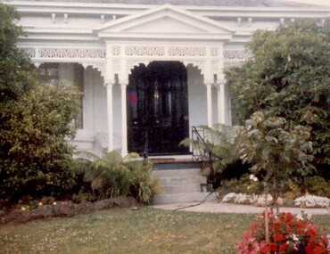
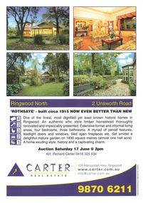 Ringwood and District Historical Society
Memorabilia - Property History, Rothsaye, 2 Unsworth Road Ringwood North, Victoria
... pages of the property history, subdivisions, land titles... containing 34 pages of the property history, subdivisions, land ..."Rothsaye" was built in 1917 by J.B. McAlpin who was a councillor in Lillydale and Ringwood and was Mayor in 1928-29.Multi pocket burgundy coloured spiral binder containing 34 pages of the property history, subdivisions, land titles and photographs of the house, compiled by Richard Carter pre-auction 17 June 2006