Showing 1352 items
matching local government council
-
 Eltham District Historical Society Inc
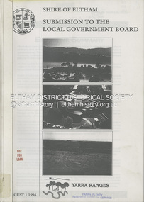
Book, Shire of Eltham, Submission to the Local Government Board: Yarra Ranges, 1 August 1994
... of Nillumbik instead. local government municipal restructuring Council ...A restructure proposal by the Shire of Eltham, named the municipality of Yarra Ranges, reflects a strategic focus. It has natural boundaries and a strong sense of place built on communities of interest. Prepared in consultation with the community and neigbouring municipalities of Diamond Valley and Heidelberg. Contents include: Principles for change, rationale for the proposal, mergers and other restructure proposals. Appendices include: community consultation, Metropolitan Green Wedge Strategy, Constituent Council Benchmark, external refernce benchmark - Moreland, communities of interest, conservation and landcare groups, social profile, key financial management strategies and more.54 pages, 11 Appendicesnon-fictionA restructure proposal by the Shire of Eltham, named the municipality of Yarra Ranges, reflects a strategic focus. It has natural boundaries and a strong sense of place built on communities of interest. Prepared in consultation with the community and neigbouring municipalities of Diamond Valley and Heidelberg. Contents include: Principles for change, rationale for the proposal, mergers and other restructure proposals. Appendices include: community consultation, Metropolitan Green Wedge Strategy, Constituent Council Benchmark, external refernce benchmark - Moreland, communities of interest, conservation and landcare groups, social profile, key financial management strategies and more.local government, municipal restructuring, council amalgamation -
 Glen Eira Historical Society
Album - Page 13 of folder D-F, Caulfield Municipality Photo Slide Collection, c.1976 - c.1994
... of Glen Eira City Council. glen eira city council local government ...The photographs for the slides are believed to have been taken by the inaugural Editor for the Caulfield Contact - the official newspaper of the former City of Caulfield from 1976-1994. The Editor was also Council's Community Liaison Officer and she (and her successor) took many photographs of official events and Council-related services and locations in connection with both these official roles. The City of Caulfield was the Municipal Council for an area of the South Eastern suburbs of Melbourne, including Brighton East, Carnegie, Caulfield, Elsternwick, Gardenvale, Glen Huntly, McKinnon, Murrumbeena, Ormond and St Kilda East. Credit: Glen Eira Historical Society - This item was digitised and made available through the Glen Eira Heritage Digitisation Strategy 2019-2023. Glen Eira Historical Society acknowledges the support of Glen Eira City Council. Page 13 of slide album D to F, in a polypropylene slide sleeve containing 12 x 35mm colour slides. A sample of 2 images from this page is included. glen eira city council, local government, caulfield city council, caulfield council, city of caulfield, caulfield contact, elsternwick, caulfield municipality photo slide collection, roads and streets, parking, shops, downshire road, glenhuntly road, trams, hopetoun gardens, parks and reserves, cannons -
 Ballarat Tramway Museum
Document - Form/s, Legal Document, Victorian Government, "Electric Supply by a Council - Order No. ", 1940
... to be used as the form basis for authorising a local government... government council to supply power within a given area. Document has ...Twenty Seven page printed document on foolscap paper to be used as the form basis for authorising a local government council to supply power within a given area. Document has spaces for the various signatures, seals, schedules and Order No. Order was granted by the Governor in Council under the electric light and power ACT of 1928. Has definitions, including railways and tramways. Schedule three allows for details of tramways and railways. Has space for the Minister in charge of Electrical Undertakings to sign the order. Has form number of 10679/40 in bottom left hand corner - therefore it has been assumed that form is printed in 1940. Stapled in the top left hand corner. Last page of document is loose.trams, tramways, sec, councils, power supply, order in council -
 Warrnambool and District Historical Society Inc.
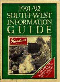
Booklet - Warrnambool Standard 1991/1992 South-West Information Guide, The Warrnambool Standard Warrnambool, 25 October 1991
... . It contains lists of local government council and councillors.... It contains lists of local government council and councillors ...This well indexed booklet was produced by the Warrnambool Standard with the assistance of the City of Warrnambool. It contains lists of local government council and councillors for the surrounding south western district. There are photographs of the Warrnambool City Council members and main officers. Information provided covers services for accommodation, animal welfare, Churches, community organisations, complaints, counselling, courts, education, employment, health, legal, material aid, public safety, recreation, recycling, community support, tourism and transport. The booklet contains advertisements for some local businesses. This service directory provides a snapshot of businesses and support services available in Warrnambool and the South Western District in 1991. It will be useful for researchers looking at this area in the late 20th century. The booklet also provides an insight into how community awareness of recycling improving our environment was undertaken in 1991.A 32 page booklet of yellow newsprint with black printing. The staples have been removed. The front cover has a green background with yellow printing on the top half. There is a black and white photograph of a man accepting bagged recycling from a woman and two children. The top left hand corner of the photograph has a small red rectangle and yellow writing. The bottom right hand corner of the front cover has a red triangle with yellow writing. The rear cover has black printing and a stylised cartoon of a man emptying a rubbish bin at the tip being tapped on the shoulder by a man holding a recycling bag.Front cover: 1991/92 South~West Information Guide The Standard Warrnambool; Keep with your telephone book for quick reference produced in conjunction with Warrnambool City Council Rear cover: Remember... If it can be recycled, It's not rubbish! Contact your local council about recycling.warrnambool city council, warrnambool service directory 1991, recycling, south western district service directory -
 Eltham District Historical Society Inc
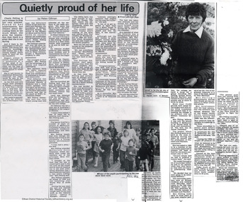
Booklet - Folder, Diamond Valley Leader, Charis Pelling, 19/06/1984
... and in local government as a Councilor. ... and in local government as a Councilor. harry gilham collection women ...Article "Quietly proud of her life" by Journalist Helen Gillman, published in the Diamond Valley Leader 19 June 1984 about Charice Pelling, her family background, work in the community and in local government as a Councilor. 2 pages (photocopy)harry gilham collection, women, charice pelling, helen gillman, charis pelling -
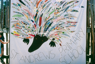 Eltham District Historical Society Inc
Slide - Photograph, St Andrews Primary School Banner, 1985
... with the Community Services Manager of this local government council, made... with the Community Services Manager of this local government council, made ...St Andrews Primary School was one of thirteen primary schools and one high school to participate in the banner project. A picture of the St Andrews Primary School banner was included in page 10 of The banner habits of the Eltham tribes : Eltham Shire "as we are" Community Banner Project report / by Jacky Talbot. The 'As We Are' Community Banner Project was the first major Community Arts project initiated and co-ordinated through the resources of the Shire of Eltham. It was originally conceived and inspired by a local textile artist, Tracey Naughton, who, together with the Community Services Manager of this local government council, made the idea a very concrete and flourishing reality. The project grew from the original fourteen or so intending participant groups to fifty-seven banners; expressions of those diverse groups' interests and identities. As a first major project it was rightly felt by Tracey Naughton, who became the Shire's first Community Arts Officer in March 1985, that it should be fully documented, so that an appraisal of the extensive growth of this community arts development process could be assessed. Given the time and money available to do this, Jacky Talbot, and her advisors, decided it was appropriate to select fifteen or twenty banners for detailed analysis. This was done by taping interviews with members of the chosen groups. The groups were chosen to cover all ages participating, from the toddlers in the Playhouse to our grand elder citizens in their Nursing Horne, and to cover a wide range of different types of groups - schools, scouts, churches, youth issue based, and the numerous women's groups of various combinations, localities and concerns. ·. Some groups who presented their banners for the culminating highlight of this project - the Exhibition, held at the Eltham Community Centre on October 9th, 1986, had no contact with the Shire or project co-ordinator, but heard about the project through the local news' networks or other participants. The extent of community participation was enormous. It involved hundreds and hundreds of people. It changed some people's lives, enlivened others. As a first step on a new road its success is notable. The 'As We Are' Community Banner Project took place in the Shire of Eltham and neighbouring environs for approximately 12 months, from October 1985.35mm colour positive transparency Mount - Cardbanners, st andrews primary school, banner project, community, emblems, flags, shire of eltham -
 Camp Eureka Working Collective
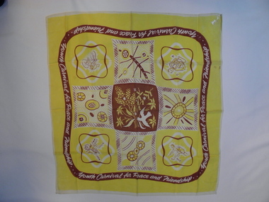
scarf
... activity. The Commonwealth Government pressured local Sydney... pressured local Sydney Councils to deny the organisers a venue ...The scarf was worn by Eileen Capocchi, a member of the Eureka Youth League Choir who sang at the Youth Carnival for Peace and Friendship and donated the item. The planned event had been targeted by Prime Minister Menzies as a Communist Party activity. The Commonwealth Government pressured local Sydney Councils to deny the organisers a venue. These attempts failed. The event combined sporting, athletic and musical events at a football stadium. In later years it was the subject of two documentary films. The scarf is of historic and social significance because of its association with the Peace Carnival for Peace and Friendship of 1952 and the Eureka Youth League. The scarves were worn by all participants and by Eureka Youth League members in subsequent years. The scarf records some of the musical and sporting events organised by the Eureka Youth League in most major Australian cities.Brown and yellow square rayon machine edged scarf made for the 1952 Youth Carnival for Peace and Friendship in Sydney. Central portion shows a peace dove, pink heath, flannel flower and wattle. Perimeter shows a saxophonist, ballet dancer, high jumper, hurdler, cyclist and volleyball net. "Youth Carnival for Peace and Friendship" white script on 3cm brown banner repeated 4 times around perimeter.eileen capocchi, eureka youth league choir, youth carnival for peace and friendship, eureka youth league, 1952 -
 Warrnambool and District Historical Society Inc.
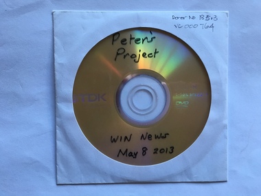
Audio Visual, Audio Visual - DVD (Peter’s Project)
... or Melbourne for treatment. Government and local Council funds have... and local Council funds have been obtained for the project ...Peter’s Project is an organization set up to raise funds for a Regional Cancer Care Centre in Warrnambool. The project was initially set up by Vicki Jellie in memory of her husband, Peter, who died of cancer some years earlier. The main aim was to build a centre for the treatment of cancer in Warrnambool so that many cancer sufferers did not have to go to Geelong or Melbourne for treatment. Government and local Council funds have been obtained for the project with the general public contributing to an appeal for $5 million. This target has been reached and the building is currently being erected. This DVD is of a May 2013 Win TV telecast of interviews and information regarding the public appeal.This DVD is of some interest as it indicates the results of one person’s campaign and the community’s response. The campaign has been very successful and will have far-reaching results. This is a plastic DVD, yellow-coloured on one side and silver on the other. It is in a white envelope with a clear plastic window. In biro – ‘Peter’s Project, Win News, May 8, 2013’ Printed on disc – TDK, Life on Record, DVD-R 1-16 x Speed, 14.7GB, DVD’ peter’s project, warrnambool regional cancer care centre -
 Warrnambool and District Historical Society Inc.
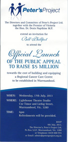
Document, Invitation Peters Project, 2013
... and local Council funds have been obtained for the project... and local Council funds have been obtained for the project ...Peter’s Project is an organization set up to raise funds for a Regional Cancer Care Centre in Warrnambool and to manage the Centre after it is built. The project was initially set up by Vicki Jellie in memory of her husband, Peter, who died of cancer some years earlier. The main aim was to build a centre for the treatment of cancer in Warrnambool so that many cancer sufferers did not have to go to Geelong or Melbourne for treatment. Government and local Council funds have been obtained for the project with the general public contributing to an appeal to raise $5 million. This target has been reached. The building is currently being erected. This invitation to the Official Launch of the appeal was sent to Bill Phillpot who was the Director of the appeal. This invitation is of some interest as it indicates the launch of the public appeal for funds for Peter’s Project and it is a great example of one person commencing a community campaign which was very successful and will have far-reaching results. This is a single-sheet card sent to Bill Phillpot by the Directors and Committee of Peter’s Project Ltd and the Premier of Victoria, Dr Denis Napthine. It is an invitation to attend the launch of the public appeal towards the building of a Cancer Care Centre. The card has blue printed material on a white background with the logo of Peter’s Project at the top left hand corner.peter’s project, warrnambool regional cancer care centre -
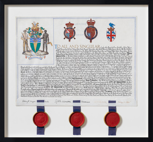 Bayside Gallery - Bayside City Council Art & Heritage Collection
Document - Certificate, College of Arms, City of Brighton Coat of Arms, 1970
... symbolism in local government". It replaced the council's crest... symbolism in local government". It replaced the council's crest ...The Coat of Arms, represents Brighton City Council's "growing awareness of the importance of formality and correct symbolism in local government". It replaced the council's crest of a pier and yachting scene and was used as council's seal, and emblem on its flag and letterhead. The new Coat of Arms, drawn up by the College of Arms in England, depicts the progression from a seaside gardening community to a modern residential city. The prominent forms are on the shield-like coat of arms include waves and a Lymphad (a ship, symbolic of the sea); a market gardener; an aboriginal man; two horns plenty with abundant fruit and vegetables (the wealth and plenty) and Elster Creek. It is underscored by the motto 'By their fruits, ye shall know them'. Brighton was first incorporated as a borough on 18 January 1859, it became a town on 18 March 1887 and was proclaimed a city on 12 March 1919.Ink and gouache on parchment with wax seals. Allocates a Coat of Arms to the City of Brighton, by the College of Arms in London on 08/09/1970. The Coat of Arms is located on the upper left quadrant and has the following parts: the crest, the wreath, the helmet and mantle, the shield, the supporters, the compartment and the motto. The crest is two cornucopias with fruits and vegetables, above which sits a seagull. The mantle above the helmet is in green and gold. The shield is also green and gold with a lymphad (ship), and blue and white waves, representing the sea. The market gardener, holding a hoe, and Aboriginal figure, bearing a boomerang, support the shield and stand upon the compartment which is soil with a representation of Elster Creek. A ribbon below contains the motto in 'FRUCTU NOSCITUR'. The certificate text explains the origins of Brighton and the parts of the coat of arms. At the bottom of the folded parchment are three signatures and titles, below which three red wax seals in gold tin containers hang from blue ribbons.coat of arms, certificate, city of brighton, college of arms, market gardener, aboriginal, wax seal, elster creek, lymphad, fructu noscitur, letters patent, armorial bearings, heraldry, seal -
 St Kilda Historical Society
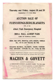
Ephemera - Catalogue, Auction Sale of Furnishings, Beds, Blankets etc of the Albert Park Emergency Hospital, 1920
... Councils, to serve influenza patients from those local government... patients from those local government areas. Each Council had three ...Catalogue for the auction of items of the Albert Park Emergency Hospital at the Drill Hall, 178 Bridport Street, Albert Park, under instruction of a combined committee of the South Melbourne, Port Melbourne and St Kilda Councils. The full date is not given. During the Spanish Flu epidemic in 1919, 34 emergency hospitals were created in Victoria because the existing hospitals were unable to cope with the demand for care. An Epidemic Hospital was set up in the Drill Room at Albert Park, the expenses shared between the South Melbourne, Port Melbourne and St. Kilda Councils, to serve influenza patients from those local government areas. Each Council had three representatives on the Board of Management. Like the other emergency hospitals, the Albert Park hospital operated only for a short time while the epidemic was at its height. As noted in the catalogue, 'the majority of the blankets, etc. were never used.' It is possible that items advertised in this catalogue were auctioned on Thursday 19 August and Friday 20 August 1920. The items for sale include hospital equipment, furniture, sheets, pillows, towels, building materials, blankets, crockery, cutlery, clothing, furnishings.Document of 3 sheets of white paper (discoloured with age), folded and stapled and printed in blackalbert park emergency hospital, spanish flu, spanish influenza -
 Bayside Gallery - Bayside City Council Art & Heritage Collection
Flag, Evan Evans, City of Brighton flag
... symbolism in local government". It replaced the council's crest... in local government". It replaced the council's crest of a pier ...The coat of arms on this flag were granted by the British College of Arms in 1970 and represented Brighton City Council's "growing awareness of the importance of formality and correct symbolism in local government". It replaced the council's crest of a pier and yachting scene and was used as council's seal, emblem on its flag and letterhead. The new Coat of Arms, drawn up by the College of Arms in England, depicts the progression from a seaside gardening community to a modern residential city. The prominent forms are on the shield-like coat of arms include waves and a Lymphad (a ship, symbolic of the sea); a market gardener; an aboriginal man; two horns of plenty with abundant fruit and vegetables (the wealth and plenty) and Elster Creek (now Elster Canal). It is underscored by the motto "By their fruits, ye shall know them". Brighton was first incorporated as a borough on 18 January 1859, it became a town on 18 March 1887 and was proclaimed a city on 12 March 1919.Green flag with circular City of Brighton Coat of Arms in the centre. The central circle is white with a yellow edge, with a polychrome coat of arms featuring: the crest which is two cornucopia with fruits and vegetables, above sits a seagull. The mantle above the helmet is in green and gold. The shield is also green and gold with a lymphad (ship) and blue and white waves. The market gardener, holding a hoe, and Aboriginal figure, bearing a boomerang, support the shield and stand upon the compartment which is soil with a representation of Elster creek. A ribbon below contains the motto in blue 'FRUCTU NOSCITUR'.flag, brighton, city of brighton, coat of arms, college of arms, market gardener, aboriginal, elster creek, lymphad, fructu noscitur, armorial bearings, heraldry, cornucopia, by their fruits ye shall know them, motto -
 Eltham District Historical Society Inc
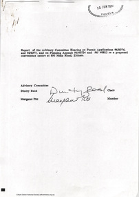
Document - Report, Dimity Reed et al, Advisory Commlttee Hearing on Permit Applications 96/0376, and 96/0377, and on Planning Appeals 96/40724 and 96/40812 re a proposed convenience centre at 895 Main Road, Eltham, June 1997
... to exist following the Liberal Kennett Government local council... to exist following the Liberal Kennett Government local council ...On 15 December 1994 the former Shire of Eltham ceased to exist following the Liberal Kennett Government local council amalgamations. A new Nillumbik Shire Council was established with unelected commissioners appointed. That Council sold the former Eltham Shire Council Offices and land at 89S Main Road Eltham to Dallas Price Homes Pty. Ltd. the sale being conditional upon the granting of a planning permit for a petrol station/convenience store, fast food and video outlet. The sale was conditional that if the permit was not granted by 30 August. 1997, the contract could be avoided by either the purchaser or the vendor. The proposed development consisted of a petrol station with undercover fuelling facilities, convenience shopping, a drive through service facility for fast food, an 80 seat cafe, automated banking, a children's play area and retail space. In addition, the proposal included a 200 square metre community facility for Council use, provision of on site carparking over 2 levels for 83 vehicles, and advertising signage. The Advisory Committee was appointed under Section 151 of the Planning and Environment Act 1987 to hear submissions on the proposal to develop the land at 895 Main Road Eltham, the site of the former Eltham Shire Offices. In September 1996, two applications were made by Contour Consultants Australia Pty Ltd on behalf of Dallas Price Homes Ply Ltd, to Nillumbik Shire Council. After extensive notification, the Council received 213 objections and a petition of over 1400 signatures. On October 9, 1996, Nillumbik Shire Council issued Notices of Decision to Grant Permit on Applications number 96/03376 and 96/0377 for the use and development of the land as a convenience Centre consisting of a petrol station, convenience store, cafe/takeaway food premises, a retail facility and a community facility, with associated advertising signs. Objectors to the proposals lodged Planning Appeals number 96/40724 and 96/40812 with the Administrative Appeals Tribunal on November 1, 1996. The grounds of appeal can be summarised as: inappropriate development, insufficient carparking, traffic and access issues, unsatisfactory design, inadequate permit conditions, the proposal being out of character with the area. and being contrary to the purpose and orderly development of the Eltham Town Centre, excessive noise, lack of consultation and unsuitable signage. On November 13, 1996, the Minister for Planning and Local Government directed the Registrar of the Administrative Appeals Tribunal. under Section 41 (1) (a) of the Planning Act 1980, to refer the Appeals to the Governor in Council for determination without a hearing or recommendation by the Tribunal. The Minister for Planning and Local Government called in the Appeals as he considered that they raised major issues of policy relating to the facilitation of development in accordance with the objectives set out in Section 4 of the Planning and Environment Act 1987, and that determination of the Appeals could have a substantial effect on the achievement of these planning objectives. The Minister required the Advisory Committee to consider the planning merits of the proposed use and development, and to address the issues raised in the objections. The Advisory Committee was required to produce a report providing: • The Committee's response to the matters detailed; • Relevant supporting information for the Advisory Committee's recommendation; and • A description of the proceedings conducted by the Advisory Committee and a list of those consulted or heard by the Committee. In March 1997, elections were held in the Shire of Nillumbik and the view of the new Council to this proposal differed from the view held by the earlier Council Hence the Submission made to the Committee by the Shire was against the decision by the Shire of Nillumbik to issue the Notices of Decision to Grant a Permit. The Recommendations of the Advisory Committee were: i. The cafe and take away food premises are as of right uses and are therefore allowable, but that shop and petrol station are unacceptable uses. A community facility is a discretionary use and is acceptable. ii. A development of the type and scale proposed is totally inappropriate for this land and that the Applications number 96/03376 and 96/0377 for the use and development of the land as a convenience Centre consisting of a petrol station, convenience store, café/takeaway food premises, a retail facility and a community facility, with associated advertising signs, be refused. iii. The land should be rezoned for public purposes and should remain in the community's ownership for community use. 895 main road, advisory committee, dallas price homes, eltham, eltham shire office, nillumbik shire council, planning application, administrative appeals tribunal -
 Eltham District Historical Society Inc
Document - Report, Paul Jerome, Advisory Committee on a Proposed Convenience Centre and an Alternative Shire Proposal - Eltham Gateway Community Precinct Concept Plan - 895 Main Road Eltham, October 1997
... to exist following the Liberal Kennett Government local council... to exist following the Liberal Kennett Government local council ...On 15 December 1994 the former Shire of Eltham ceased to exist following the Liberal Kennett Government local council amalgamations. A new Nillumbik Shire Council was established with unelected commissioners appointed. That Council sold the former Eltham Shire Council Offices and land at 89S Main Road Eltham to Dallas Price Homes Pty. Ltd. the sale being conditional upon the granting of a planning permit for a petrol station/convenience store, fast food and video outlet. The sale was conditional that if the permit was not granted by 30 August. 1997, the contract could be avoided by either the purchaser or the vendor. The proposed development consisted of a petrol station with undercover fuelling facilities, convenience shopping, a drive through service facility for fast food, an 80 seat cafe, automated banking, a children's play area and retail space. In addition, the proposal included a 200 square metre community facility for Council use, provision of on site carparking over 2 levels for 83 vehicles, and advertising signage. An Advisory Committee consisting of Dimitry Reed and Margaret Pitt was appointed under Section 151 of the Planning and Environment Act 1987 to hear submissions on the proposal to develop the land at 895 Main Road Eltham, the site of the former Eltham Shire Offices. In September 1996, two applications were made by Contour Consultants Australia Pty Ltd on behalf of Dallas Price Homes Ply Ltd, to Nillumbik Shire Council. After extensive notification, the Council received 213 objections and a petition of over 1400 signatures. On October 9, 1996, Nillumbik Shire Council issued Notices of Decision to Grant Permit on Applications number 96/03376 and 96/0377 for the use and development of the land as a convenience Centre consisting of a petrol station, convenience store, cafe/takeaway food premises, a retail facility and a community facility, with associated advertising signs. Objectors to the proposals lodged Planning Appeals number 96/40724 and 96/40812 with the Administrative Appeals Tribunal on November 1, 1996. The grounds of appeal can be summarised as: inappropriate development, insufficient carparking, traffic and access issues, unsatisfactory design, inadequate permit conditions, the proposal being out of character with the area. and being contrary to the purpose and orderly development of the Eltham Town Centre, excessive noise, lack of consultation and unsuitable signage. On November 13, 1996, the Minister for Planning and Local Government directed the Registrar of the Administrative Appeals Tribunal. under Section 41 (1) (a) of the Planning Act 1980, to refer the Appeals to the Governor in Council for determination without a hearing or recommendation by the Tribunal. The Minister for Planning and Local Government called in the Appeals as he considered that they raised major issues of policy relating to the facilitation of development in accordance with the objectives set out in Section 4 of the Planning and Environment Act 1987, and that determination of the Appeals could have a substantial effect on the achievement of these planning objectives. The Minister required the Advisory Committee to consider the planning merits of the proposed use and development, and to address the issues raised in the objections. The Advisory Committee was required to produce a report providing: • The Committee's response to the matters detailed; • Relevant supporting information for the Advisory Committee's recommendation; and • A description of the proceedings conducted by the Advisory Committee and a list of those consulted or heard by the Committee. In March 1997, elections were held in the Shire of Nillumbik and the view of the new Council to this proposal differed from the view held by the earlier Council Hence the Submission made to the Committee by the Shire was against the decision by the Shire of Nillumbik to issue the Notices of Decision to Grant a Permit. The Recommendations of the Advisory Committee were: i. The cafe and take away food premises are as of right uses and are therefore allowable, but that shop and petrol station are unacceptable uses. A community facility is a discretionary use and is acceptable. ii. A development of the type and scale proposed is totally inappropriate for this land and that the Applications number 96/03376 and 96/0377 for the use and development of the land as a convenience Centre consisting of a petrol station, convenience store, café/takeaway food premises, a retail facility and a community facility, with associated advertising signs, be refused. iii. The land should be rezoned for public purposes and should remain in the community's ownership for community use. Following this, the Minister for Planning and Local Government, the Hon. Robert Maclellan, appointed Mr. Paul Jerome as an Advisory Committee under section 151 of the Planning and Environment Act 1987 to consider a Convenience Centre and an alternative proposal by Iha Shire of Nillumbik being the Eltham Gateway Community Precinct Concept Plan for the site of the former Shire of Eltham municipal offices at 895 Main Road, Eltham. In summary, the terms of reference for the Advisory Committee required it to: • consider the merits of the Council proposal • examine the merits of both proposals in terms of net community benefit • address the report of the previous Advisory Committee on the Convenience Centre proposal The Advisory Committee inspected the site and considered all the material before It including submissions made by all parties to the previous Advisory Committee and correspondence received by the Department of Infrastructure both before and after that Committee submltted its report. The Advisory Committee also held discussions with the following people: • Cr. Robert Marshall • Cr. Margaret Jennings • Cr. Lex de Man • Mr. Dallas Howgate of Dallas Price Properties, also Dallas Price Homes • Mr. Barry Rochford, CEO, Shire of Nillumbik • Ms. Yvonne Rust, Planning Officer, Shire of Nillumbik • Mr. Gregory Burgess, Architect of the Eltham Library and of Council’s Community Precinct Concept Plan • Mr. Jim Connor representing Mrs Thelma Barkway of the Eltham Senior Citizens Club Having considered all the material before it, the Committee arrived at two basic conclusions. First, the DPP proposal should be rejected because, on its merits, It does not sufficiently satisfy the requirements of the planning scheme which is a statutory document. The planning scheme requires that, before making a decision on the permit applications for the DPP proposal, a range of matters must be considered. It follows that consideration of these matters should Influence the decision. These matters include local policies relating to character and amenity. In particular, these policies seek • to conserve and enhance the bushland/country atmosphere, artistic heritage and strong sense of community of the Eltham Town Centre by ensuring that the design and height of any new development is sympathetic to existing buildings • to achieve a pleasing physical environment within the Eltham Town Centre by encouraging a high standard of architecture and urban design • to encourage Improvement to pedestrian amenity through such facilities as open and shattered rest areas and meeting places, crossing facilities, pedestrian arcades, pedestrian links to car parks and pedestrian weather protection • to reduce conflict between vehicular traffic and pedestrian flows, and • to encourage pedestrian thoroughfares It is submitted, as set out In the main body of this report, that the DPP proposal fails substantially to meet these policies and In so doing does not merit the exercise of discretion In Its favour with the Issuing of a permit. This finding is not offset by the investment and employment attributes of the proposal. They do not override the need to comply with the planning scheme. Second, the Council proposal, on Its own merits, substantially meets all statutory requirements applicable to this site with a possible reservation about car parking and traffic management which need further definition and assessment as the concept is refined. The Council proposal, however, has a serious weakness in that Its financial viability has not been adequately tested. The Committee refers to 'financial' rather than 'commercial' viability in recognition that Council owns the land and may enter into a range of agreements and partnerships to realise its concept some of which may be truly commercial and some of which may involve an element of subsidy arising from Council's involvement as a public body acting on behalf of its community. The Committee concludes that Council should be given the opportunity, within a reasonable timeframe to establish the financial feasibility of its concept and should develop a strategy for the future of Its land asset at 895 Main Road in the event that Its concept for the site cannot be realised. 895 main road, advisory committee, dallas price homes, eltham, eltham shire office, nillumbik shire council, planning application, administrative appeals tribunal -
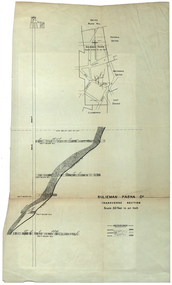 Federation University Historical Collection
Plan, Sulieman Pasha Co Plan Transverse Section
... , and church submitted a 60 person petition to the local council..., and church submitted a 60 person petition to the local council ...The Sulieman Pasha is possibly named after the most important Sultan of the Ottoman Empire, Suleiman One, or Suleiman the Magnificent, when the Ottoman Empire was at its peak. Or potentially a number of Ottoman governors, statesmen and military commanders with the same name after, however the spelling is slightly different to the mine name. No Turkish connection was found relating to the formation of the company, and remains unconfirmed. The mine operated from two shafts; No. 1 near the corner of Humffray and Mair streets, and also near where the Welcome Nugget (2217 ounces) was found years earlier; and the controversial No. 2 shaft several blocks south bordering the northern side of the main highway through Ballarat. The company produced 62 666 ounces of gold, the twelfth highest quartz reef gold production for any mine on the Ballarat goldfield. Some crushing figure examples are January-June 1881: 3674 tonnes 1085 ounces; January-June 1885: 2949 tonnes 1281 ounces; July-December 1885: 4459 tonnes 1119 ounces; January-June 1887: 1869 tonnes 730 ounces; July-December 1892: 1450 tonnes 771 ounces; July-December 1896: 4365 tonnes 1372 ounces. Like many mines in the area, gold grades were low. John Watson was noted as mine manager in the 1880s, and John Williams 1890s. The company was re-organised twice increasing the number of shares from 4000 to 24 000, and increasing the capital available. The Sulieman Pasha Company was formed in 1878. David Fitzpatrick was given the honour of turning the first sod of both the No.1 and later No. 2 shafts. The first dividend was given to shareholders in July 1881. The company obtained a prospecting vote (government grant) to start, and was very proud to be the first Victorian gold mining company to pay the funds back to the government. The event was marked by a lavish banquet laid out for ministers and government officials by the company. Leases were purchased to the south in 1885 to the Llanberris Mine boundary, after poor results began accumulating from the small No. 1 shaft. To take advantage of this new land the company planned to sink a second shaft. Initially this was to take place on government land, but the uproar from nearby residents caused the company to purchase land along the Main Road (now Western Highway), and the old Yarrowee Hotel which had occupied the site since the alluvial digger days of the 1850's was demolished. The area had since those days become heavily occupied with a number of shops, houses, a post office, church and two schools in the immediate area. The thought of an underground mine next door drew considerable opposition. The company (before the days of public relations departments) wrote 'most people would have thought that progress as vital as mining would be supported by tradesmen whose business rely on the mining industry. It seems when it comes to mining they are bereft of their senses, and considering the low ebb of mining in Ballarat East, the action of our opponents are unaccountable. (Sarcastically) There are certain engineering difficulties in moving the quartz reefs to a new location, but if we could to appease our opponents we would'. The company also wanted to take over 4 acres of the St Paul's school oval for machinery, but accused the St Paul's Church of wanting extortionate amounts of money upfront, and on a yearly basis for the privilege. It stated the church could not be opposed to mining when several years earlier it had formed its own company to mine the land, only for shareholders to lose their money. In 1886, the company approached the Minister for Mines, and attended heated public meetings on the matter. The local residents, shop owners, and church submitted a 60 person petition to the local council and government authorities. They stated the shaft contravened the mining statutes, which stating no mining could take place within 150 yards of a public building or church. A speech by a resident stated 'mining always comes with glorious pictures of the great benefits which would accrue all parties concerned if their request is granted, but if property is destroyed or depreciated in value, no-one then comes forward and compensates them'. The No. 2 shaft was approved including taking over part of the school oval. In 1888, workers at the company's No. 2 shaft went on strike to try and bring their wages in line with other mines in the district (the No. 1 shaft was operated by tributers). William Madden (26) was killed from a fall of earth underground the same year, while a year later his father John Madden (70) was similarly killed in the Madame Berry Mine elsewhere in the district. In 1897 as the amount of gold being found fell away, it came to light part of the deal to purchase the Yarrowee Hotel site was a 5% royalty on gold found. Shareholders could not understand why they were paying a royalty to the former owners of the property. The mine closed in 1898 due to a lack of gold. In 1902 a boy (age unknown) called Charles Lee was killed from a fractured skull while working to dismantle the Sulieman Pasha plant. The fuss over the No. 2 shaft had a sequel. On the company winding up, the land was purchased by J.S. Trethowan who built a house next to the shaft. In 1907, the shaft caved-in creating a sinkhole immediately at the back of the house. A Mr Chamberlain heard a deep rumbling sound at 5am, and looked out the window to see his fowl house and thirteen chickens disappear down an expanding hole. He then went back to bed, and called the police later in the day. The shaft was 1050 feet deep, and the hole at the surface that developed was 20 feet by 17 feet across, and 20 feet depth. In 1930 it is reported a syndicate had been formed to clean out the old shaft, and re-open the mine. It is assumed this was the No. 1 shaft but no more was found. (https://www.mindat.org/loc-304239.html, accessed 07/08/2019) A transverse section plan of the Sulieman Pasha Mine.sulieman pasha company, plan, mining, united black hill mine, victoria united mine, victoria street, britannia united mine, last chance mine, llanberris mine, ottoman empire, john watson, john williams, david fitzpatrick -
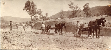 The Beechworth Burke Museum
Photograph, Late 1800s
This photograph depicts six men and two horses with carts in the process of constructing a road. The men each stand in a relatively relaxed position, posing for the camera. However, the amount of upturned soil surrounding them suggests the hard work they have endured, armed only with pitchforks and shovels. The creation of new roads in the Beechworth area had become a priority for the Beechworth council in the second half of the nineteenth century. This included connecting roads which radiated out of Beechworth to surrounding towns. This led to the expansion of the local government authority over the surrounding countryside, greatly strengthening Beechworth's central position. The use of horse and cart to take away the removed soil, as well as the style of the men's attire, suggests that this photograph dates back to the late 1800s. It can also be assumed that this photograph was taken somewhere in the surrounding hills of Beechworth. This photograph is historically significant as it provides insight into the rapid expansion of roads in and around Beechworth during the second half of the nineteenth century. Sepia rectangular photograph on matte photographic paper mounted on card Reverse: BMM 2982 / road construction, beechworth roads, 1800s, 1800s beechworth, beechworth hills, horse and cart, beechworth road making, beechworth council roads, road expansion, beechworth surrounding hills -
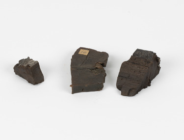 The Beechworth Burke Museum
Geological specimen - Coorongite
Coorongite is a dark, rubber-like, highly resilient structureless algal deposit. In the Coorong district of South Australia it occurs in moderate quantities associated with the coastal swamps and sand dunes which extend for a considerable distance east of the mouth of the Murray. This particular specimen was recovered from the south of the Coorong River, South Australia. A type of sediment rich in organic matter, Coorongite is the unlithified end-member of the sapropelic coal series. The members of the sapropelic coal series can be ranked in order as sapropel (the unlithified form), sapropelic-lignite, and sapropelic-coal (the lithified forms) based on increasing carbon content and decreasing volatile content. Sapropel (Coorongite) is an unlithified dark, pulpy, fine organic mud containing concentrations of algae and miospores that are more or less identifiable. Coorongite is typically found as an algae like substance, that can be found in irregular size pieces. Coorongite was believed to be dried up oil due to its rubber-like texture. The Coorongite is also soft to the point where it can be cut into with a knife or it can be broken and torn by hand. Otherwise known as 'Kurangk', the Coorong River is home to the Ngarrindjeri people, which acts as both a place for gathering food and a spiritual place. In 1852 the first sight of Coorongite was found along the Coorong River. The finders mistook the Coorongite for dried up oil, which lead to the belief that there were oil reserves under the Coorong River. Between the 1860s and the 1930s the Coorong River became a place where mining oil and Coorongite became precedent. Nowadays, the local council and the South Australian Government are working together with the Ngarrindjeri people to sustain and preserve the Coorong River and the culture that is with it. Soon after gold was discovered in 1851, Victoria’s Governor La Trobe wrote to the Colonial Office in London, urging ‘the propriety of selecting and appointing as Mineral Surveyor for this Colony a gentleman possessed of the requisite qualifications and acquaintance with geological science and phenomena’. Alfred Selwyn was appointed geological surveyor in Australia in 1852 which began the Geological Survey of Victoria. Selwyn went on to collect geological samples and catalogue thousands of specimens around Australia. In 1853-69 the Geological Survey issued under Selwyn's direction sixty-one geological maps and numerous reports; they were of such high standard that a writer in the Quarterly Journal of the Geological Society of London bracketed the survey with that of the United States of America as the best in the world. During his years spent in Australia, Selwyn collected numerous significant geological specimens, examples of which are held in collections such as the Burke Museum.Coorongite is considered to be a mineral with a unique texture, where it can be both hard and soft. Coorongite can also be considered to be a rare mineral, as it is only located along the Coorong River and due to the mining of it, has left very few sources. It was believed at one point that Coorongite could be used to replace oil. This specimen is part of a larger collection of geological and mineral specimens collected from around Australia (and some parts of the world) and donated to the Burke Museum between 1868-1880. A large percentage of these specimens were collected in Victoria as part of the Geological Survey of Victoria that begun in 1852 (in response to the Gold Rush) to study and map the geology of Victoria. Collecting geological specimens was an important part of mapping and understanding the scientific makeup of the earth. Many of these specimens were sent to research and collecting organisations across Australia, including the Burke Museum, to educate and encourage further study.Three solid varyingly hand-sized pieces of wooden appearing organic matter derived from the river in the Coorong District in South Australia. A rubber-like, highly resilient structureless algal deposit.Specimen 245 page 69 / in Descriptive Register / "Elcestic Bitumen, / Coorangite" South of / Coorung River, South Australia . / C. WIllman / 15/4/21burke museum, beechwoth, indigo shire, beechworth museum, geological, geological specimen, mineraology, coorong, coorong river, kurangk, ngarrindjeri, south australia, coorongite, coorongite specimen -
 The Beechworth Burke Museum
Audio - Oral History, Jennifer Williams, Mrs Val Mason, 5 January 2001
Mrs. Valerie (Val) Mason (1927-2019) was a local sheep farmer, business-woman, Beechworth shire councillor, and mother to five children. With her husband, Charles, Mrs. Mason developed and managed the Big Valley farm estate, at Everton, which is now part of a vineyard and farm stay. Mrs. Mason was instrumental in introducing a 'paddock to plate' philosophy and business model, opening a butcher shop on the farm in 1973. Concerned with improving infrastructure and developing economic opportunities in the region, Mrs. Mason successfully stood as a local council representative for South Riding in the United Shire of Beechworth, and later become the first woman Shire President in 1979. Mrs Mason was a member of the local Business and Professional Women's Club for 37 years. This oral history recording was part of a project conducted by Jennifer Williams in the year 2000 to capture the everyday life and struggles in Beechworth during the twentieth century. This project involved recording seventy oral histories on cassette tapes of local Beechworth residents which were then published in a book titled: 'Listen to what they say: voices of twentieth century Beechworth. These cassette tapes were digitised in July 2021 with funds made available by the Friends of the Burke.Mrs. Mason's story is historically significant for understanding economic and social changes in the Beechworth region during the latter half of the twentieth century. As a council representative, issues such as road and infrastructure modernisation and the transition from traditional government employment sectors, like Beechworth's care institutions, were challenges for local government. As a farmer and local employer, Mrs. Mason's story is testimony to the region's economic diversification as businesses like Big Valley farm shop helped shape the region's contemporary character. Mrs. Mason was among the first women to broach the traditionally all-male Beechworth Council Chambers and her story is socially significant for understanding the changing role of women in rural and regional Australia. This oral history recording offers interpretive capacity for social history themes and may be compared with other oral histories in the Burke Museum's collection. This oral history account is socially and historically significant as it is a part of a broader collection of interviews conducted by Jennifer Williams which were published in the book 'Listen to what they say: voices of twentieth-century Beechworth.' While the township of Beechworth is known for its history as a gold rush town, these accounts provide a unique insight into the day-to-day life of the town's residents during the 20th century, many of which will have now been lost if they had not been preserved.This is a digital copy of a recording that was originally captured on a cassette tape. The cassette tape is black with a horizontal white strip and is currently stored in a clear flat plastic rectangular container. It holds up 40 minutes of recordings on each side.Mrs Val Mason /listen to what they say, beechworth, oral history, burke museum, working women, trail blazers, farm to plate, farm shop, paddock to plate, woman farmer, united shire of beechworth, rural and regional women, beechworth's first woman shire president, women in leadership positions, women leaders, australian settlement history, settler societies, victorian gold rush, heritage tourism, culinary tourism, regional land use, indigo winery, farm stay, social history -
 The Beechworth Burke Museum
Photograph, Unknown c.1900s
... Shire Local Victorian Government Black and white rectangular ...This image depicts a group of local counsellors from the Shire of Beechworth (est. mid to late 1900s). The identities of those within the photo remain unknown. The table and chairs featured in the image were produced in the late 19th century and have been in continual use for more than 100 years. The councellors would likely have convened in the Beechworth Town Hall. A History of Beechworth: Gold was discovered in the May Day Hills district in 1852. A canvas and timber settlement soon developed as prospectors rushed to the area. Over four million ounces of gold was recovered in the first 14 years. Between 1852 and 1857, Beechworth was a gold-producing region and centre of government, boasting many industries and a multicultural population. Beechworth was proclaimed a borough on the 11th of September 1863, a formalisation of the municipal incorporation of the town seven years before. This image is associated with the history of Beechworth; it reveals the identities of local counsellors, persons whose contribution to the Beechworth Shire could otherwise be lost to time. Black and white rectangular photograph, unmounted.beechworth council, indigo shire, local victorian government -
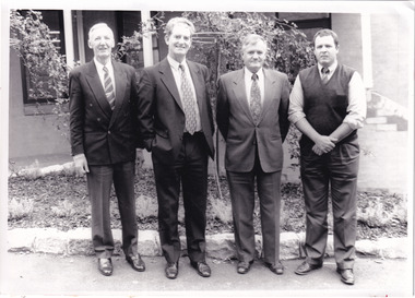 The Beechworth Burke Museum
Photograph - Photograph - Reproduction, c1994
... of Beechworth Shire Council. The only local government entity remaining ...This photograph was taken in 1994 and depicts four Commissioners of the newly formed Shire of Indigo. The Commissioners were appointed on 18 November 1994 and served until the the election of Indigo Shire Councillor's on 15 March, 1997. The United Shire of Beechworth was established in 1871 following the merger of two entities: the Borough of Beechworth, established in 1856, and the Shire of Beechworth, which was created as the union of the Stanley and Wooragee Road Districts in 1865. This photograph is historically significant for its depiction of newly elected Indigo Shire Commissioners, who replaced the former United of Beechworth Shire Council. The only local government entity remaining in Victoria styled as a 'United Shire' at its dissolution in November 1994, the amalgamation of the United Shire of Beechworth, along with parts of the Shires of Chiltern, Rutherglen and Yackandandah into the Shire of Indigo, was part of an extensive restructuring of Victoria's Local Government Areas in the 1990s. The Victorian Governments restructuring of LGA's in the 1990s constituted a major transition in Victoria's systems of local governance. The reforms dissolved over two hundred councils and sacked sixteen hundred elected councillors. The Shire of Indigo was one of seventy-eight new councils that were subsequently created through amalgamations.Black and white rectangular photograph printed on photographic paper mounted on board.Reverse (original): Transcribed to DB / From left to right: Commissioner Kevin Gleeson ~ / Chairman of Commissioners, Mr Frank Burfitt ~ / Chief Executive Officer, Commissioner Kevin Crow, ~ / Commissioner Henry Brewer. / Commissioners were appointed to the Indigo Shire / on 18th November, 1994 and served until the / election of councillors on 15th March, 1997. / indigo shire council, shire councillors, indigo shire commissioners, governance, local government, beechworth, local representatives 1994-1997, lga restructuring, indigo shire amalgamation, victorian government, regional and rural governance, beechworth shire, yackandandah shire, chiltern shire, rutherglen shire -
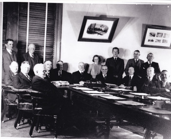
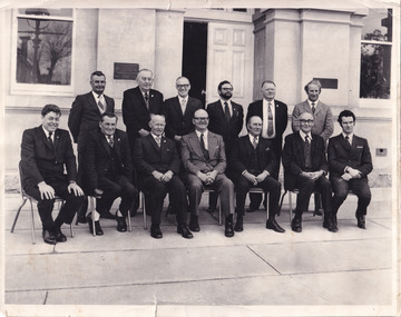 The Beechworth Burke Museum
Photograph, 1973
Taken in 1973, this photograph features 13 men in suits, most of whom are council members of the United Shire of Beechworth, as well as a secretary and engineer. The photo is taken in a formal setting, suggesting there may have been an occasion at this time (potentially surrounding or related to the August council meeting). Previously a district (1856), then a borough (1863) and separate shire (1866) at this time the Local Government Area (LGA) had been known by this name for approximately two years, after having amalgamated with the still-existing borough. Beechworth amalgamated with Rutherglen and Chiltern Yackandandah to become the Indigo Shire Council in 1994. Little has been found about the men in the photograph, however this was at also around the time that women were becoming more widely accepted into positions on Victorian council (such as Valerie Mason, who was elected the first President of the United Shire of Beechworth council 6 years after this photograph.) The photograph has been taken in front of the Beechworth Shire Hall. The Hall was designed by architects J.J. Coe and Thomas Dalziel and is dated to 1859. Originally the building was used as the Shire Offices but also doubled as a fire station and a courthouse, with still surviving cells underneath. The Town Hall is now home to the Visitor Information Centre, is the starting point for historical Precinct walking tours and is available for hire for events or community meetings.The Beechworth Town Hall is one of five distinctive granite buildings on Ford Street that comprise the Justice Precinct, and is listed on the Victorian Heritage register. This photograph captures the ongoing importance and use of the Beechworth Town Hall and its ties to Council operations in the 1970s.Black and white rectangular photograph print matt photographic paperReverse - written in pencil upper right corner: 1997.2602; stamped in black ink across centre margin: Beechworth shire council Aug.1973/ Crs.H.H.Warner, H.C.Lucas, L.W. Powell, L. Leentjes, R.C. Sewell, T.J. Carroll/ G.Gray (Secry), Crs.R.P. O'Connor, D. Nankervis, D. McKenzie-McHaig, J.J. Macaulay, H.R. Sinclair/ D.Pope (Engineer), Absent Cr.J.V.Diffey; written in pencil in cursive lower left margin: Absent J Diffey; written in pencil bottom right edge: BMMA02602beechworth shire council, crs.h.h.warner, h.c.lucas, l.w. powell, l. leentjes, r.c. sewell, t.j. carroll, g.gray (secry), crs.r.p. o'connor, d. nankervis, d. mckenzie-mchaig, j.j. macaulay, h.r. sinclair, d.pope (engineer), cr.j.v.diffey, beechworth town hall -
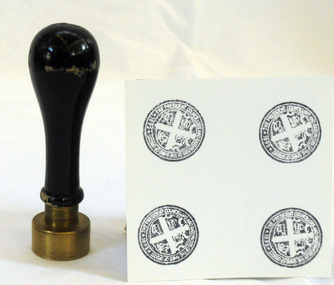 Orbost & District Historical Society
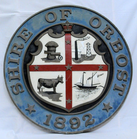
Council Seal
... East Gippsland Shire council. Local governments play ...This item was used as a seal (stamp) on official Shire Council documents. The coat of arms of the Shire of Orbost was designed in the form of a cross in which five stars are depicted on a shield. A small crown above the cross indicates the loyalty of the president,councillors and ratepayers to the reigning monarch. The inner section of the shield contains 4 figures, a sheaf of wheat, a factory, a co and a ship - all representing the activities of agriculture, fishing,industry and dairying undertaken in the shire. Originally part of the Bairnsdale district, Orbost split away as part of the Tambo Shire in 1882, and became a shire in its own right as the Shire of Croajingolong on 30th May,1892. The name was changed to the Shire of Orbost on 17th February, 1893. The Orbost Shire Council was abolished on 2nd December, 1994 as part of a state-wide program of local government reform to become part of the newly constituted East Gippsland Shire council.Local governments play an important role in the lives of citizens in Australia. Local government authorities exist to provide services and amenities to local communities, and are also responsible for regulating and providing services for land and property in their district. This item is representative of a time when Orbost had its own Shire Council.The former Orbost Shire Council Seal (stamp) depicting the coat of arms. The circular seal is brass and has a wooden handle with a bulb shaped top.President, Councillors and Ratepayers of the Shire of Orbost-1892orbost orbost-shire-council government history seal -
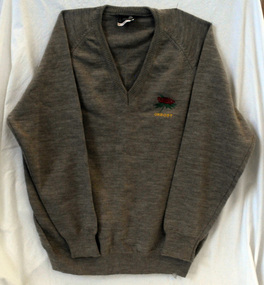 Orbost & District Historical Society
jumper, 1970's -1980's
... to become part of East Gippsland Shire Council. Local governments ...This jumper was worn by John Court as an employee of Orbost Shire Council. Orbost was at first included in the Bairnsdale Shire from 1882 and was later part of the Tambo Shire. Because of travelling distances the Croajingalong Shire was created in 1892 (name changed to Orbost Shire 17.2.1893 with James Cameron as the first Shire President. In 1994 it amalgamated to become part of East Gippsland Shire Council.Local governments play an important role in the lives of citizens in Australia. Local government authorities exist to provide services and amenities to local communities, and are also responsible for regulating and providing services for land and property in their district. This item is representative of a time when Orbost had its own Shire Council.A fawn coloured V - necked long-sleeved woollen jumper. It has a waratah emblem embroidered in red with green leaves. Below this is embroidered the word ORBOST in gold.uniform jumper orbost-shire-council court-john -
 Orbost & District Historical Society
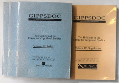
books, Gippsland Institute of Advanced Education, Gippsdoc A Bibliography of Gippsland, 2292.`1; 2292.2; 2292.3 in 1989 and 2292.4 in 1993
The Gippsland Institute of Advanced Education was opened on 20 November 1976. The Council of the Institute included members of the Gippsland community who are prominent in local government, industry, commerce, education and the professions, the Director of the Institute, and representatives of the academic staff, students, and graduates. The institute assumed responsibility for the diploma courses previously offered by the Yallourn Technical College. Initially, all the Institute's teaching was conducted in the diploma building of the Yallourn Technical College. In 1972 the Institute transferred part of its operations to the first of its permanent buildings on a large campus in rural surrounds near the township of Churchill.These books are useful reference tools.Four thick volumes of "Gippsdoc A Bibliography of Gippsland". Volumes 1, 2 and 3 have blue covers and Volume 4, the Supplement, has a beige cover. Volume 3 has 1072 pp and is an index. These books list published books which are about Gippsland.books-a-bibliography-of-gippsland gippsland-institute-of-advance-education -
 Orbost & District Historical Society
Invitation, 1969
The current building was opened on Friday 28th February 1969 by the Premier of Victoria, The Hon. Sir Henry E. Bolte, K.C.M.G., M.P. The Shire of Orbost was a local government area about 380 kilometres east of Melbourne, the state capital of Victoria, Australia. The shire covered an area of 9,347 square kilometres and existed from 1892 until 1994. Originally, Orbost was part of the Bairnsdale Road District which was created on 30 April 1867. Splitting away as part of the Shire of Tambo in 1882, Orbost was first incorporated as a shire in its own right as the Shire of Croajingolong on 30 May 1892. It received its present name on 17 February 1893. On 3 January 1913 part of its western riding was annexed to Tambo as its Cunninghame Riding. Local governments play an important role in the lives of citizens in Australia. Local government authorities exist to provide services and amenities to local communities, and are also responsible for regulating and providing services for land and property in their district. This item is representative of a time when Orbost had its own Shire Council. A stapled program and invitation to the official opening of the new Orbost Shire Council Municipal Offices. A light blue card with the Orbost Shire Council insignia and gold print on front. The invitation is addressed to the secretary of Orbost Historical Society Judith Walcott.handwritten in blue pen - "Judith G Walcott"orbost-shire-council -
 Orbost & District Historical Society
document, 18th October, 1977
This survey had been sent to the Orbost Rifle Club c/- C. Curtis.The Shire of Orbost was a local government area about 380 kilometres (236 mi) east of Melbourne, the state capital of Victoria, Australia. The shire covered an area of 9,347 square kilometres (3,608.9 sq mi), and existed from 1892 until 1994 when it was merged as part of East Gippsland Shire Council.A nine page document stapled in the left-hand corner. It is a recreational survey issued by the Shire of Orbost. It is inside a a large manila envelope which is addressed to the Orbost Rifle club. It contains a covering letter and a form.survey shire-of-orbost orbost-rifle-club -
 Orbost & District Historical Society
plaque
The Coat of Arms of the Shire of Orbost has been designed in the form of a cross in which five stars are set on a shield. This was typical of those used by many shires and cities throughout Victoria and the Commonwealth. A small crown above the cross indicates the loyalty of the President, Councillors and Ratepayers to the reigning King or Queen. The inner circle of the shield contains four figures, a sheaf of wheat, a factory, a cow, and a ship, which represents the activities of agriculture, fishing, industry and dairying undertaken in the district. Originally part of the Bairnsdale district, Orbost split away as part of the Shire of Tambo in 1882, and became a Shire in its own right as the Shire of Croajingolong on the 30th may 1892. The name changed to the Shire of Orbost on 17 February 1893. Orbost was divided into four ridings on 31st May 1895, they were the North, South, East and Central riding, which was represented by three elected councillors. The Shire coat of arms was on the wall on the right of the front entrance to the building and was removed from the current building when Orbost Shire Council was amalgamated into East Gippsland Shire in 1994.The current building was opened on Friday 28th February 1969 by the Premier of Victoria, The Hon. Sir Henry E. Bolte, K.C.M.G., M.P. Local governments play an important role in the lives of citizens in Australia. Local government authorities exist to provide services and amenities to local communities, and are also responsible for regulating and providing services for land and property in their district. This item is representative of a time when Orbost had its own Shire Council. A large round metal plaque with the words SHIRE OF ORBOST1892 in gold letters around a crown and shield divided into four sections to represent four industries : Shipping ; farming - maize ; dairy and mining.SHIRE OF ORBOST 1892government orbost-shire-council coat-of-arms plaque -
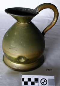 Flagstaff Hill Maritime Museum and Village
Functional object - Jug, Between 1910 -1936
The beginning of standardised weights and measures began In Victoria when the Melbourne Observatory received sets of standard weights and measures, which had been tested in Britain against the then British Imperial standards. These included the primary standard yard and pound for the Colony of Victoria. Other standards of weights and measure held by shires and the administrative body's within the colony could then be compared to these primary standards. A Weights and Measures Act was passed in Victoria in 1862, establishing local inspectors throughout the colony. By the 1870s each local council and shire in Victoria held a set of standards that were used to test scales, weights and dry measures used by wholesalers, factories and shops. Every ten years the councils’ standards would themselves need to be rechecked against the Victorian Standards. The checking was done by the Victorian Customs Department in the 19th century, but with the transfer of responsibility for customs to the Federal Government in 1901, weights and measures function was retained by the Victorian Government and was shifted to the Melbourne Observatory. In 1904, a new building was erected at the south end of the Great Melbourne Telescope House, where the standard weights and measures and testing equipment was installed. This room had a large whirling apparatus for testing air meters and became known as the Whirling Room. When the Melbourne Observatory closed in 1944, the Weights and Measures Branch was formed to continue and this branch remained at the Observatory site unit until 1995.An example of a brass measuring jug made specifically to maintain government standard liquid measurements that were sold to the public. The probability is that this artefact was made sometime between George V reign (1910-1936) and gives us today a snapshot of how imperial weights and measures were checked by Government departments prior to decimalisation and how a standard for the various types of measurement was developed in Australian based on the Imperial British measurement system. The container has social significance as an item used in Victoria as a legal standard measure to ensure that goods sold in Victoria were correct. Jug brass haystack form with a deep lip and pouring spout, small neck and broad base. It displays a curved pistol handle. Inscription at base of handle top of jug stamped 61 GVR SM. These marks signify that the measure complied with the Victorian Government capacity liquid standard measurement. Item made during the reign of George V (1910-1936 (GVR).Other marks indicate model number (61) & SM possible could be either small measure, the maker, or Standards Melbourne.flagstaff hill, warrnambool, shipwrecked-coast, flagstaff-hill, flagstaff-hill-maritime-museum, maritime-museum, shipwreck-coast, flagstaff-hill-maritime-village -
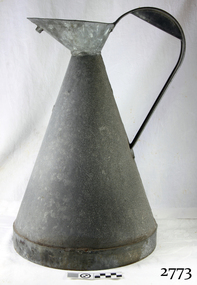
 Flagstaff Hill Maritime Museum and Village
Equipment - Galvanised Jug, 1930s
The beginning of standardised weights and measures began In Victoria when the Melbourne Observatory received sets of standard weights and measures, which had been tested in Britain against the then British Imperial standards. These included the primary standard yard and pound for the Colony of Victoria. Other standards of weights and measure held by shires and the administrative body's within the colony could then be compared to these primary standards. A Weights and Measures Act was passed in Victoria in 1862, establishing local inspectors throughout the colony. By the 1870s each local council and shire in Victoria held a set of standards that were used to test scales, weights and dry measures used by wholesalers, factories and shops. Every ten years the councils’ standards would themselves need to be rechecked against the Victorian Standards. The checking was done by the Victorian Customs Department in the 19th century, but with the transfer of responsibility for customs to the Federal Government in 1901, weights and measures function was retained by the Victorian Government and was shifted to the Melbourne Observatory. In 1904, a new building was erected at the south end of the Great Melbourne Telescope House, where the standard weights and measures and testing equipment was installed. This room had a large whirling apparatus for testing air meters and became known as the Whirling Room. When the Melbourne Observatory closed in 1944, the Weights and Measures Branch was formed to continue and this branch remained at the Observatory site unit until 1995.An example of a galvanised measuring jug made specifically to maintain government standard liquid measurements that were sold to the public. The probability is that this artifact was made around the first quarter of the 20th century and gives us today a snapshot of how imperial weights and measures were used before decimalisation and how a standard of measurement for merchants was developed in Australian based on the Imperial British measurement system. The container has social significance as an item used in Victoria as a legal standard measure to ensure that goods sold in Victoria were correct given the item is galvanised it was probability used for kerosene or petrol etc not for liquids used for human consumption. Jug conical shaped with rounded top coming to a very slight point wide handle at back. VIB.L.66 1/2 Gall capacity unsure of the markings 66 could mean the model number capacity is 1/2 an imperial gallon VIB.L markings not known possibly a company or Victorian Department that the jug was made for and no longer active.flagstaff hill, warrnambool, shipwrecked-coast, flagstaff-hill, flagstaff-hill-maritime-museum, maritime-museum, shipwreck-coast, flagstaff-hill-maritime-village -
 Flagstaff Hill Maritime Museum and Village
Galvanised Jug
The beginning of standardised weights and measures began In Victoria when the Melbourne Observatory received sets of standard weights and measures, which had been tested in Britain against the then British Imperial standards. These included the primary standard yard and pound for the Colony of Victoria. Other standards of weights and measure held by shires and the administrative body's within the colony could then be compared to these primary standards. A Weights and Measures Act was passed in Victoria in 1862, establishing local inspectors throughout the colony. By the 1870s each local council and shire in Victoria held a set of standards that were used to test scales, weights and dry measures used by wholesalers, factories and shops. Every ten years the councils’ standards would themselves need to be rechecked against the Victorian Standards. The checking was done by the Victorian Customs Department in the 19th century, but with the transfer of responsibility for customs to the Federal Government in 1901, weights and measures function was retained by the Victorian Government and was shifted to the Melbourne Observatory. In 1904, a new building was erected at the south end of the Great Melbourne Telescope House, where the standard weights and measures and testing equipment was installed. This room had a large whirling apparatus for testing air meters and became known as the Whirling Room. When the Melbourne Observatory closed in 1944, the Weights and Measures Branch was formed to continue and this branch remained at the Observatory site unit until 1995. An example of a galvanised measuring jug made specifically to maintain government standard liquid measurements that were sold to the public. The probability is that this artifact was made around the first quarter of the 20th century and gives us today a snapshot of how imperial weights and measures were used before decimalisation and how a standard of measurement for merchants was developed in Australian based on the Imperial British measurement system. The container has social significance as an item used in Victoria as a legal standard measure to ensure that goods sold in Victoria were correct given the item is galvanised it was probability used for kerosene or petrol etc not for liquids used for human consumption. Galvanised Iron jug with rounded top, Inscription on handle at back. 2 gallon GV.35flagstaff hill, warrnambool, shipwrecked-coast, flagstaff-hill, flagstaff-hill-maritime-museum, maritime-museum, shipwreck-coast, flagstaff-hill-maritime-village