Showing 96 items
matching locality plan
-
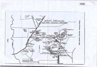 Greensborough Historical Society
Map, Mont Park buildings still existing, 1946_
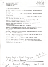
... Locality Plan indicates buildings still existing within... Plenty Lower Plenty melbourne Locality Plan indicates buildings ...Locality Plan indicates buildings still existing within the Mont Park - Larundel mental health complex; Table lists 16 buildings by year built, initial purpose, subsequent uses and current address2 pages,one map, one table larundel, mont park -
 Kew Historical Society Inc
Plan - Subdivision Plan, Belford Heights Estate, Kew, ca. 1925
... Locality Plan also includes the route of the Outer Circle Railway... in Strathalbyn Street, which opened in 1892. The inset Locality Plan also ...Pru Sanderson, in her groundbreaking ‘City of Kew Urban Conservation Study : Volume 2 - Development History’ (1988), summarised the periods of urban development and subdivisions of land in Kew. The periods that she identified included 1845-1880, 1880-1893, 1893-1921, 1921-1933, 1933-1943, and Post-War Development. These periods were selected as they represented periods of rapid growth or decline in urban development. An obvious starting point for Sanderson’s groupings involved population growth and the associated economic cycles. These cycles also highlighted urban expansion onto land that was predominantly rural, although in other cases it represented the decline and breakup of large estates. A number of the plans in the Kew Historical Society’s collection can also be found in other collections, such as those of the State Library of Victoria and the Boroondara Library Service. A number are however unique to the collection.The Kew Historical Society collection includes almost 100 subdivision plans pertaining to suburbs of the City of Melbourne. Most of these are of Kew, Kew East or Studley Park, although a smaller number are plans of Camberwell, Deepdene, Balwyn and Hawthorn. It is believed that the majority of the plans were gifted to the Society by persons connected with the real estate firm - J. R. Mathers and McMillan, 136 Cotham Road, Kew. The Plans in the collection are rarely in pristine form, being working plans on which the agent would write notes and record lots sold and the prices of these. The subdivision plans are historically significant examples of the growth of urban Melbourne from the beginning of the 20th Century up until the 1980s. A number of the plans are double-sided and often include a photograph on the reverse. A number of the latter are by noted photographers such as J.E. Barnes.The Belford Heights Estate was a subdivision in Kew East, even though the title of the plan indicates that it was located in Kew. The subdivision had been approved by 1915, and included 105 lots facing Strathalbyn, Kitchener, Hamilton and Beresford Streets, as well as Balfour and Belford Roads. Those lots hand coloured with red probably represent blocks that had been sold. The additional information provided on the plan is also of interest. The plan includes the original location of East Kew State (Primary) School in Strathalbyn Street, which opened in 1892. The inset Locality Plan also includes the route of the Outer Circle Railway and the location of the Wilsmere and East Kew Stations. The location of the landmark Harp of Erin Hotel is also marked on the Locality Plan.belford heights estate, subdivision plans - kew -
 Ringwood and District Historical Society
Flyer, Land Sale Advertisement - State School Estate, Ringwood, Victoria - 1923
... Locality plan includes King Street and Government Roads... Ringwood) which opened in 1925, Locality plan includes King Street ...The date of the flyer as circa 1920 can be estimated from the references to the (decision on) "electrification of the Croydon Railway Line" which eventually occurred in 1923, letting of tenders for the state school building which opened in 1924, and the "proposed new railway station" (East Ringwood) which opened in 1925, Advertisement for State School Estate, Ringwood - 26 residential allotments for sale near East Ringwood State School development site and 7 minutes walk from proposed new railway station (East Ringwood). Includes location map and terms of sale.Locality plan includes King Street and Government Roads (Later Everard Road, Holland Road, Purser Avenue, and Charles Street). (Agents) J.B. McAlpin, Estate Agent and Subdivisional Manager, Ringwood (Opposite Station), and F.V. Parker, Estate Agent, Main Street, Ringwood. -
 Glen Eira Historical Society
Document - Nithsdale
... of Caulfield Heights Estate on 27/10/1888. Includes locality plan... locality plan and subdivisions. Photocopied copy of flyer ...Photocopied copy of flyer for forthcoming subdivision of Caulfield Heights Estate on 27/10/1888. Includes locality plan and subdivisions. Photocopied copy of flyer for forthcoming sale of properties and mansion, Nithsdale on 18/09/1889, includes map of area.carriages and coaches, caulfield heights estate, caulfield north, maxwell grove, kambrook road, neerim road, blake street, bambra road, racecourse road, auctioneers, station street, glen eira road, paynes j., mansion, beauchamp brothers -
 Ringwood and District Historical Society
Map, Proposed Subdivision - Hilltop Estate, Heathmont, Victoria - circa 1925
... Plan of Part of Crown Allotments 16 & 18, Parish... Ryrie Street. Inset locality plan also shows nearby Electric ...Plan of Part of Crown Allotments 16 & 18, Parish of Ringwood, County of Mornington. Subdivision includes Site for Heathmont Station, Heathmont Road, George Street, Lilian Street, Edith Street, Edna Street, Great Ryrie Street. Inset locality plan also shows nearby Electric Railway Estate and Heathmont Station Estate. L.H. Webber, Licensed Surveyor, 440 Little Collins Street, Melbourne. -
 Ringwood and District Historical Society
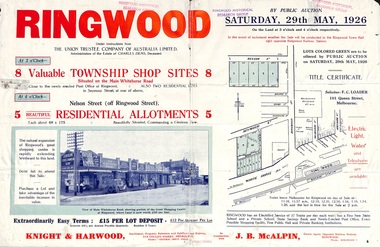
Flyer, Township Shop Sites and Residential Allotments Sale By Public Auction, Ringwood, Victoria - 1926
... Locality plan highlights sites for auction in Nelson Street... Road Ringwood North melbourne Locality plan highlights sites ...Advertisement for eight township shop sites and five residential allotments for sale by Public Auction on the land in Ringwood on Saturday, 29th May, 1926, with location map, and summary of local features and services. Locality plan highlights sites for auction in Nelson Street, Seymour Street and Whitehorse Road. (Agents) Knight & Harwood, 315 Collins Street, Melbourne, Phones 10615, 10616 Central, in conjunction with J.B. McAlpin, Estate Agent, Opposite Railway Station, Ringwood, Phone Ringwood 7. -
 Ringwood and District Historical Society
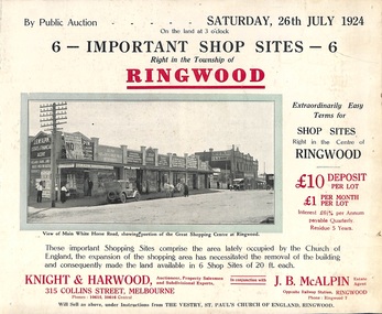
Flyer, Shop Sites Sale By Public Auction, Ringwood, Victoria - 1924
... Locality plan highlights shop sites for auction east... Road Ringwood North melbourne Locality plan highlights shop ...Folded double-sided brochure advertising six Ringwood shop sites for sale by Public Auction at 3pm, Saturday, July, 1924, with town photographs, location map, and summary of local features and services. Includes newspaper extract from the Real Estate and Property section from "Evening Sun", 6th June, 1924.Locality plan highlights shop sites for auction east of Pratt Street along Whitehorse Road. (Agents) Knight & Harwood, 315 Collins Street, Melbourne, Phones 10615, 10616 Central, in conjunction with J.B. McAlpin, Estate Agent, Opposite Railway Station, Ringwood, Phone Ringwood 7. -
Glen Eira Historical Society
Plan - Ristori
... of the 24 subdivisions available plus a locality plan are included... a locality plan are included along with details of separate sale ...Real Estate leaflet for the subdivision sale of the Ristori Estate & Residence on 31/05/1919 by Yeo, Crosthwaite & Co. A map of the 24 subdivisions available plus a locality plan are included along with details of separate sale on 04/06/1919 of the weatherboard buildings, rooms, stables & glass house.house names, 'ristori', land sales, sewerage, glen eira road, brick houses, land subdivision, orrong road, glasshouses, yeo crosthwaite & co melbourne, ripponlea, stables, ristori estate, auctions, drainage, liscard street, st. georges road, balaclava road, glen huntly road, glenhuntly road, elsternwick station, hotham street, weatherboard buildings, elsternwick -
 Ringwood and District Historical Society
Flyer, Land Sale Advertisement - Sunbeam Estate, East Ringwood, Victoria - circa 1930
... Locality plan includes Holland Road, Everard Road, Sunbeam... Road Ringwood North melbourne Locality plan includes Holland ...Folded double-sided page advertising private sale of 48 residential allotments, with location map, terms of sale, and details of local features and services. Locality plan includes Holland Road, Everard Road, Sunbeam Avenue, Mount Dandenong Road, and Lilydale Road (later Old Lilydale Road). (Agents) Phillips & Nicholson, 59 Swanston Street, Melbourne, (Phone) Central 10907, in conjunction with C.E. Carter, Bank Chambers, Main Street, Ringwood, Telephone Ringwood 24. -
 Melbourne Tram Museum
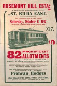
Ephemera - Real estate sale, Prahran Hodges, "Rosemont Hill Estate", Oct. 1917
... , the plan of the subdivision, and a general locality plan showing... of the subdivision, and a general locality plan showing tram and rail lines ...Pamphlet advertising the sale of land at the "Rosemont Hill Estate", Balaclava Road, St Kilda East, 6-10-1917. On the front cover has a photo of PMTT tram No. 27. Gives terms of sale, the plan of the subdivision, and a general locality plan showing tram and rail lines. Land prices have been written in for some blocks on the pamphlet. Demonstrates the style of land sale pamphlet including the availability of tram services to prospective purchasers.Pamphlet - folded - printed in two colours of cream coloured paper with photographs and plans.has pencil notes re sale price and notes for some blocks.sale of land, trams, real estate, balaclava road, st kilda east, pmtt, tram 27, rosemont hill estate -
 Bendigo Historical Society Inc.
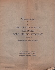
Document - MCCOLL, RANKIN AND STANISTREET COLLECTION: RED WHITE AND BLUE EXTENDED GM - PROSPECTUS, 1940
... - Bendigo , Locality plan shows Nell Gwynne Line, New Chum Line... - Bendigo , Locality plan shows Nell Gwynne Line, New Chum Line ...Documents: prospectus - 8 page booklet, inside back cover attached diagram - longitudinal section Sheepshead Line of Reefs - Bendigo , Locality plan shows Nell Gwynne Line, New Chum Line, sheepshead line, Deborah line, transverse section for Sheepshead line. Prospectus of Red White and Blue Extended Gold Mining Company No Liability Sheepshead Reef, Bendigo to be incorporated under the provisions of part 2 of the companies Act 1938, Victoria.MCCOLL RANKIN STANISTREETorganization, business, gold mining - legal, mccoll rankin stanistreet, red white and blue extrended gold mining company, nell gwynne line, new chum line, sheepshead line, deborah line. -
 Bendigo Historical Society Inc.
Document - STATE RIVERS AND WATER SUPPLY COMMISSION : GENERAL DESCRIPTION AND PARTICULARS OF EPPALOCK PROJECT, 1/08/1961
... to 1st August 1961, Eppalock Reservoir Locality Plan (diagram... to 1st August 1961, Eppalock Reservoir Locality Plan (diagram ...State Rivers and Water Supply Commission. Seven-page typed document titled 'General description and particulars of the Eppalock Project.' Subheadings: General, Administration and Works Installation, Field laboratory, Construction programme, Design statistics, Major items of plant in use on the project, Progress to 1st August 1961, Eppalock Reservoir Locality Plan (diagram), Eppalock project works area & arrangement plan (diagram), Eppalock Project cross section of dam along? tunnel (diagram).state infrastructure, water supply, coliban system, state rivers and water supply commission. coliban system. eppalock. -
 Federation University Historical Collection
Plan - Plans, Ballarat School of Mines Albert Street Buildings, 1979
... buildings: .1) Locality Plan .2) Trade Workshop Site Plan .3) Trade... of SMB Albert St buildings: .1) Locality Plan .2) Trade Workshop ...The Trade Workshops became known as the M.B. John Building, and later housed Ballarat Tech.Eight printed plans with coloured shading of SMB Albert St buildings: .1) Locality Plan .2) Trade Workshop Site Plan .3) Trade Workshop Floor Plan Level A & B .4) Trade Workshop Floor Plan Level C .5) Trade Workshop Floor Plan Level D .6) Trade Workshop Floor Plan Level E .7) Trade Workshop West Elevation and Sections .8) Trade Workshop North Elevations and Sections building plans, smb trade workshops, ewan jones and associates pty ltd, architectural plan, m.b. john building, albert street -
 Bendigo Historical Society Inc.
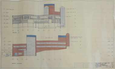
Document - CAMBRIDGE PRESS COLLECTION: ACCOUNT - LANSELL'S ENGINEERING
... the top. Below is a shape with a locality plan of Bendigo... with a locality plan of Bendigo and a dark brown line going from Charing ...Note/account paper with brown printed letterhead. Date line with 192-. Lansell's Engineering Works Bendigo across the top. Below is a shape with a locality plan of Bendigo and a dark brown line going from Charing Cross to Lansell's Engineering Works via View St, Barnard ST and Inglewood Rd where it turns left into a smaller unnamed street. On the left are the names of E. Lansell, E F V Norbury and L V Lansell (Managing Director).business, printers, cambridge press, cambridge press collection, lansell's engineering works, charing cross, sterry's hotel, lansell's 180, e lansell, e f v norbury, l v lansell -
Kew Historical Society Inc
Plan - Camberwell Panorama Estate, 1923
... the site and a locality plan, while page 4 includes photographs... information about the site and a locality plan, while page 4 includes ...Subdivision plans and real estate flyers/brochures reveal a number of aspects of urban development and history. The Kew Historical Society's collection of these plans, as well as advertisements extracted from magazines, cover key aspects of community development and architectural history of Kew and Kew Eat as well as surrounding suburbs. While most of the plans in the collection were gifted to the Society by the former City of Kew, a number of other plans and advertisements have been donated by individuals, of which this is an example.Promotional brochure for the Camberwell Panorama Estate. The four page bifold handout advertises 216 home sites bounded by Bulleen Road, The Nook, Fortuna Avenue, and Doncaster Road. Other streets in the subdivision include: Sunburst Avenue, The Moor, and Macedon Avenue. The brochure has been damaged at some time in the past and so masking tape obscures the tram on page 1. Page 2 includes the plan of the subdivision, page 3 information about the site and a locality plan, while page 4 includes photographs and terms of sale. subdivision plans -- balwyn north (vic.), camberwell panorama estate -
Kew Historical Society Inc
Plan - Saxonwood Estate, Doncaster [East]
... . The final page includes a locality plan. ... plans -- Doncaster east (Vic.) Undated, multi-page subdivision ...Subdivision plans and real estate flyers/brochures reveal a number of aspects of urban development and history. The Kew Historical Society's collection of these plans, as well as advertisements extracted from magazines, cover key aspects of community development and architectural history of Kew and Kew Eat as well as surrounding suburbs. While most of the plans in the collection were gifted to the Society by the former City of Kew, a number of other plans and advertisements have been donated by individuals, of which this is an example.Undated, multi-page subdivision plan advertising lots for sale bounded by Blackburn Road, George Street, Windermere Avenue, and Saxonwood Drive in what is currently Doncaster East. Other streets in the subdivision include: Mowbray Court, Stafford Court, Rugby Court, and Robin Hood Court. The front page includes a Birdseye view of the estate which identifies existing and projected civic amenities, as well as the estate's relationship to surrounding suburbs and the city centre. Red crosses on the detailed plan of lots on page two indicate those that have been sold. The final page includes a locality plan. saxonwood estate -- doncaster east (vic.), subdivision plans -- doncaster east (vic.) -
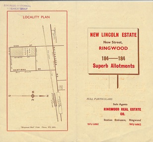 Ringwood and District Historical Society
Document - Folder, Land Sale Brochure, New Lincoln Estate, Ringwood, Vic. - circa 1960. Also 1951 newspaper advertisement
... of local facilities and services, locality plan, layout of sub..., with summary of local facilities and services, locality plan, layout ...Bi-fold advertisement for sale of residential allotments - New Lincoln Estate, New Street, Ringwood, with summary of local facilities and services, locality plan, layout of sub-division, and price list. Also an advertisement from Ringwood Mail dated 12 July 1951. Subdivision includes New Street, Heywood Street, Barkly Street, Keith Grove, Maurice Avenue, Inez Avenue, Catherine Street, Neville Street, Neale Grove (later Heather Grove), and Sylvia Grove. Agent - Ringwood Real Estate Co., Station Entrance, Ringwood. (Phone) WU 6661, WU 6662.Accompanying handwritten sales notes researched in 2024 by Richard Carter - Carter Real Estate ... "Maurice Ashkanasy KC CMG owned the rectangular estate located between New, Barkly, Heywood Streets and Sylvia Grove in South-West Ringwood. It was given the name "The New Lincoln Estate". It was first advertised around July 1951 as "48 superb allotments", through Ringwood Real Estate (Station Entrance). A sub-divisional plan from CE Carter showed 152 blocks with 60-foot frontages and varying between 110 and 150 feet in length. Later, in 1954 house and land packages were offered through William White in Elsternwick - "Three modern bedrooms, large lounge-dining-room, kitchen with dinette, nicely equipped bathroom - £2,685 to £2,762, deposit £300". The roads were created and named after family members - Neale (later Heather) Grove - after Maurice's son Neal Mark Ashkanasy. The street was later re-named Heather Grove after Maurice's wife, Heather Helen Ashkanasy (Epstein), who passed away in 1999, aged 95. Neville Street - after Marice's other son, Aaron Solomon Neville Ashkanasy known as Neville. Catherine Street and Inez Street - after Heather's mother Catherine Inez Epstein. Maurice Avenue - after Maurice Ashkanasy, vendor. Keith Grove - after Keith Epstein. ..." -
 Whitehorse Historical Society Inc.
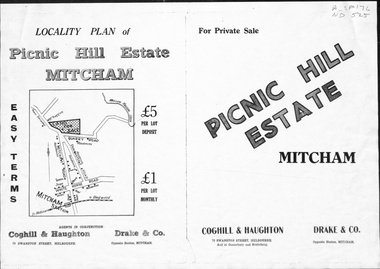
Pamphlet, Picnic Hill Estate, Mitcham, n.d
... Photocopy of pamphlet, locality map and plan of 40 home... Photocopy of pamphlet, locality map and plan of 40 home sites ...Photocopy of pamphlet, locality map and plan of 40 home sites on Picnic Hill estate extending from Quarry Road, Mitcham Road and McKeon Road, Mitchamland subdivision, mitcham road, mitcham, quarry road, mckeon road, wooddale grove, rotherwood avenue, cobham road -
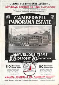 Melbourne Tram Museum
Ephemera - Real estate sale, Cranny Sambell & Co, "Camberwell Panorama Estate", Oct. 1923
... to the corner. This extension took place in 1937. The locality plan... to the corner. This extension took place in 1937. The locality plan ...Pamphlet advertising the sale of land at the "Camberwell Panorama Estate" - Doncaster and Bulleen Road 13-10-1923. Gives terms of sale, photos showing the views and a nearby shopping centre. Has a large photo of MMTB No. 20 on the front cover. The tramcar is of the Hawthorn Tramways Trust four-door bogie type. MMTB No 20 was an ex-Prahran and Malvern single trucker or small tram A class. Gives details of the 110 lots to be sold, terms, location, and that the tram was proposed to be extended to the corner. This extension took place in 1937. The locality plan shows proposed plans for tram lines in Belmore Road and Burke Road north of Whitehorse Road. Demonstrates the style of land sale pamphlet including the availability of tram services to prospective purchasers.Pamphlet - folded - printed in two colours of cream coloured paper with photographs and plans.has pencil notes on the top of the front page.sale of land, trams, real estate, camberwell panorama estate, east camberwell, doncaster road, bulleen road, tram 20 -
 Flagstaff Hill Maritime Museum and Village
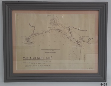
Document - Location Chart, The Mahogany Ship, 2007
... Lower left: "THE MAHOGANY SHIP" "LOCALITY PLAN, ENLARGED... Griffiths Land Lower left: "THE MAHOGANY SHIP" "LOCALITY PLAN ...This chart shows a possible site for the fabled wreck called the 'Mahogany Ship'. Flagstaff Hill’s collection includes other objects that some say could be relics from this Ancient Wreck, (also called the Gold Ship, or the Ancient Vessel). The chart shows the coordinates for the Summits of Griffith Island and of Middle Island. It also has the depths of the sea at various intervals and shows the shore and sand dunes, lighthouses and other reference points. The mystery of the Mahogany Ship began in 1836 when two shipwrecked sealers discovered the remains of an “ancient vessel” in the sand dunes about four miles west of Warrnambool. Since the last recorded sightings in the 1880’s the true origin of the Mahogany Ship has remained one of Australia’s most famous historical mysteries or fables. One of the more recent theories is that the vessel was one of the Portuguese ships exploring the Australian coast in 1522. For over one hundred years searchers have attempted to locate and identify the wreck. The search continues for the tangible evidence which will once and for all establish the Mahogany Ship’s place in Australia’s History.The chart represents the worldwide interest in locating the wreck of the Mahogany Ship. Locating the actual wreck or proving the existence of a Portuguese ship's wreck could change the history of the discovery of Australia. A Mahogany Ship committee was formed to gather and research information about the discovery of the wrecked ship. A large amount of money was offered as a prize for finding the wreck or parts of it. People have written books, painted images, made videos and told tales of the ship but it continues to remain a mystery or even a fable. The chart is significant for its possible link to one of Victoria’s and Australia’s maritime mysteries, the Mahogany Ship (also known as the Ancient Wreck). It is one of very few known relics that could give evidence of the existence and history of the vessel. It is listed on the Victorian Heritage Register S438 as it is one of Victoria’s oldest recorded shipwrecks. The identity of the vessel has the potential to change Australia’s history.A chart in a wooden frame, behind glass. The chart shows the approximate position of the mystery Ancient Wreck, later called the "Mahogany Ship". The chart is a copy and is based on the Admiralty Chart by Lieut. Stanley, dated 1872. Lower left: "THE MAHOGANY SHIP" "LOCALITY PLAN, ENLARGED FROM LIEUT. STANLEY'S ADMIRALTY CHART 1872" "APPROXIMATE POSITION OF WRECK MARKED [symbol of a Portuguese cross]" Other labels on chart: "BELFAST" "PORT FIARY" "GRIFFITHS I" "RIVER MOYNE" "RIVER MERRI" "ARMSTRONG BAY" " GORMANS LANE" "TOWER HILL" "KOROIT" "HELEN ROCK" "WARRNAMBOOL" "LADY BAY" "MIDDLE I" "LIGHT HO." Lower right: "G 410 B" Label on the back; "This chart presented to the Mahogany Ship Committee and Flagstaff Hill by Avis Quarrell, April 2007"warrnambool, shipwrecked coast, flagstaff hill maritime museum, shipwreck coast, mahogany ship, ancient vessel, ancient wreck, portuguese ship, coastal reserve, fabled wreck, gold ship, griffiths island, belfast (now port fairy), koroit, location plan, leuit. stanley, admiralty chart 1872, tower hill, merri river, moyne river, middle island, helen rock, armstrong bay, griffiths land -
 Whitehorse Historical Society Inc.
Letter - Correspondence, East Burwood Reserve, 1993
... Burwood Reserve including acquisition of land, details, plans... Burwood Reserve including acquisition of land, details, plans ...Various documents relating to the establishment of East Burwood ReserveVarious documents relating to the establishment of East Burwood Reserve including acquisition of land, details, plans, locality map, news cuttings and photographs. Appears to be copy of Nunawading City Council File April 1993Various documents relating to the establishment of East Burwood Reserve sportsgrounds, east burwood reserve, soilleur (dr), hitchens, anna, blue moon fruit co-operative ltd., jacobson and logan, king family, central methodist mission, aussat, tally ho, sewart, bill -
 Bendigo Historical Society Inc.
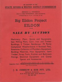
Document - IAN DYETT COLLECTION: AUCTION CATALOGUE - BIG EILDON PROJECT
... and accessories. Catalogue has a Locality Plan of Eildon, photo, locality... and accessories. Catalogue has a Locality Plan of Eildon, photo, locality ...Two red covered auction catalogues for an auction on account of the State Rivers & Water Supply Commission on the 22nd to 25th November, 1954 (inclusive) held at the Big Eildon Project, Eildon, Victoria. Lots sold include Machinery, plant, stores and equipment, Saw Milling Plant, corr. Iron and timber buildings, 5 timber residences, 73 partly completed weatherboard 4 roomed flats, extensive collection of plumbers equipment, building materials, mess equipment, sawn timber, scrap, tools, kitchen and bathroom fittings, electrical equipment and costly spares and accessories. Catalogue has a Locality Plan of Eildon, photo, locality and description of the Eildon Sawmill. Photos of completed houses, incomplete flats and plan showing layout of flat unit, photo of flat block (Completed). Also Building Kits - Designs and Component Lists.business, auctioneers, j h curnow & son pty ltd, ian dyett collection - auction catalogue - big eildon project, state rivers & water supply commission, j h curnow & son pty ltd, eildon sawmill, prahran telegraph printing co -
 Ringwood and District Historical Society
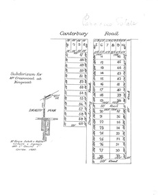
Plan, Paradise Estate Subdivision, Ringwood, Victoria - circa 1925
... Locality plan showing land for sale south of Canterbury.... Locality plan showing land for sale south of Canterbury Road, 1 ...Paradise Estate layout also included in Land Sale Brochure Titled Eureka Plan Book - Seven Delightful & Valuable Ringwood Estates - circa 1925, Reg. No. 5100.Subdivision plan of Paradise Estate, Ringwood, showing allotments for sale, with typed page attached showing block sizes and prices.Locality plan showing land for sale south of Canterbury Road, 1 Mile south of Ringwood Railway Station. Subdivison includes Canterbury Road and Dandenong Road (later Wantirna Road). Surveyors - McKenzie Aisbett & Webber, surveyors & engineers, 440 Little Collins Street, Melbourne, Telephone Central 11540. Subdivision for Mr Grenwood at Ringwood. Additional typewritten price list showing footage, price per foot, and price per block for Lots No. 1 to 60. Paradise Estate layout also included in Land Sale Brochure Titled Eureka Plan Book - Seven Delightful & Valuable Ringwood Estates - circa 1925, Reg. No. 5100. -
 Kew Historical Society Inc
Plan - Subdivision Plan, Oswinia Estate, East Kew, c.1925
... that had been sold. The inset locality plan is particularly... that had been sold. The inset locality plan is particularly ...Prue Sanderson, in her groundbreaking ‘City of Kew Urban Conservation Study : Volume 2 - Development History’ (1988), summarised the periods of urban development and subdivisions of land in Kew. The periods that she identified included 1845-1880, 1880-1893, 1893-1921, 1921-1933, 1933-1943, and Post-War Development. These periods were selected as they represented periods of rapid growth or decline in urban development. An obvious starting point for Sanderson’s groupings involved population growth and the associated economic cycles. These cycles also highlighted urban expansion onto land that was predominantly rural, although in other cases it represented the decline and breakup of large estates. A number of the plans in the Kew Historical Society’s collection can also be found in other collections, such as those of the State Library of Victoria and the Boroondara Library Service. A number are however unique to the collection.Subdivision plans are historically important documents used as evidence of the growth of suburbs in Australia. They frequently provide information about when the land was sold on which a built structure was subsequently constructed as well as evidence relating to surveyors and real estate and financial agents. The numerous subdivision plans in the Kew Historical Society's collection represent working documents, ranging from the initial sketches made in planning a subdivision to printed plans on which auctioneers or agents listed the prices for which individual lots were sold. In a number of cases, the reverse of a subdivision plan in the collection includes a photograph of a house that was also for sale by the agent. These photographs provide significant heritage information relating house design and decoration, fencing and household gardens.The ‘Oswinia Estate’ subdivision in East Kew was planned and auctioned in the first half of the 1920s. 169 allotments were created in the triangular section of land bordered by High Street, Burke Road and the Government Boulevard (later Kilby Road). The only piece of land excluded was that where the previous Kew Pound had been located at the east tip of the triangle. Allotments were created fronting Glass, High, Namur, Oswin Streets, Irymple Avenue, and the Government Boulevard. The name for the Estate was derived from Oswin’s farm, which had been one of the largest landholdings in East Kew. The selling agents annotated the plan in our collection with crosses indicating those lots that had been sold. The inset locality plan is particularly interesting as it shows the route and stations of the Outer Circle Railway. When the subdivision plan was created, it included the proposed bridge over the Yarra at Burke Road. The bridge was to be officially opened in 1926.subdivision plans - east kew, oswinia estate, high street, glass street, namur street, government boulevard - kilby road, irymple street, oswin street -
 Kew Historical Society Inc
Plan - Subdivision Plan, Camberwell Mountain View Estate, 1923
... . In the Locality Plan on the left side of the subdivision plan, Deepdene.... In the Locality Plan on the left side of the subdivision plan, Deepdene ...The Kew Historical Society collection includes almost 100 subdivision plans pertaining to suburbs of the City of Melbourne. Most of these are of Kew, Kew East or Studley Park, although a smaller number are plans of Camberwell, Deepdene, Balwyn and Hawthorn. It is believed that the majority of the plans were gifted to the Society by persons connected with the real estate firm - J. R. Mathers and McMillan, 136 Cotham Road, Kew. The Plans in the collection are rarely in pristine form, being working plans on which the agent would write notes and record lots sold and the prices of these. The subdivision plans are historically significant examples of the growth of urban Melbourne from the beginning of the 20th Century up until the 1980s. A number of the plans are double-sided and often include a photograph on the reverse. A number of the latter are by noted photographers such as J.E. Barnes.The so-called Camberwell Mountain View Estate was a subdivision on ‘the corner [of] Burke Road, Eyre and Wills Streets, Deepdene’. The Estate was not the first attempt to subdivide this land holding. In 1884, 1888 and 1894 the Belmore Park subdivision proposed 18 allotments for this parcel of land. The final stages of the Belmore Park subdivision occurred during the Depression of the 1890s. Apart from perhaps one block facing Burke Road, which is unnumbered in the Mountain View Estate subdivision, the rest must have remained unsold. The later subdivision would redraw the original 18 allotments, creating 22 new lots. In the Locality Plan on the left side of the subdivision plan, Deepdene Station, which formed part of the Outer Circle Railway is represented, as is the location of Deepdene Primary School. A selling point was the proposed extension of the Burke Road tram beyond its terminus at Cotham Road. The extension did not eventuate.subdivision plans - camberwell, mountain view estate -
 Bendigo Historical Society Inc.
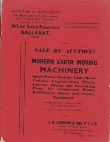
Document - IAN DYETT COLLECTION: AUCTION CATALOGUE - WHITE SWAN RESERVOIR
... is a Locality Plan showing location of lot areas - access roads, etc.... Were the auctioneers. Included in the catalogue is a Locality ...Three auction catalogues, two with red covers and the third is missing the cover. Sale of Earth Moving Machinery. Spare Parts, Machine Tools, Motor Trucks, Engineering Plant, Concrete Mixing and Batching Plant, Air Compressor Plants, Buildings, Stores and Costly Equipment on 31st March to 5th April 1952 (inclusive) at the White Swan Reservoir, Ballarat, Victoria. J. H. Curnow & Son Pty. Ltd. Were the auctioneers. Included in the catalogue is a Locality Plan showing location of lot areas - access roads, etc. Page 4 has a black and white photo showing Super c Tournapull, Lot 63 and Tractor hauling 12-15 cub. Yd. capacity scoop. Page 9 photo is Lot 209, a Sheep's Foot Roller, Page 12 photo is Lots 258, 259 & 260 - Class 1 tractor hauling two 12-15 c yd Te Tourneau Scrapers, and page 68 has a black & white photo of Lot 2377, the Concrete Batching Plant.business, auctioneers, j h curnow & son pty ltd, ian dyett collection - auction catalogue - white swan reservoir, the ballarat water commissioners, j h curnow & son pty ltd, prahran telegraph printing co -
 Whitehorse Historical Society Inc.
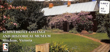
Pamphlet, Schwerkolt Cottage and Historical Museum, 1/06/1998
... of the museum, coloured photographs and locality and site plans...., coloured photographs and locality and site plans. Schwerkolt ...Whitehorse City Council publicity pamphlet giving the history of the cottage and the Schwerkolt family. Includes the farm in Separation Street, Northcote. In Mitcham the farm was a 'mixed' one with fruit trees, vines, dairying, poultry, bee hives, wine making and a stone quarry. Includes details of the museum, coloured photographs and locality and site plans.jackschowsky, mary elizabeth, schwerkolt, johann august, richter, paulina, oppel, maria catherina wilhelmine, deep creek road, mitcham, city of whitehorse, nunawading and district historical society inc, city of nunawading, delacombe, rohan (sir), schwerkolt cottage -
 Ringwood and District Historical Society
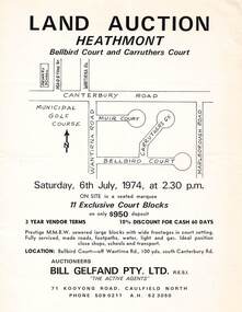
Flyer - Land Auction, Carruthers Estate, Heathmont, Victoria - 1974
... on Saturday, 6th July, 1974, with locality map and plan of subdivision..., 1974, with locality map and plan of subdivision in Carruthers ...Double-sided page advertising auction of 11 allotments on Saturday, 6th July, 1974, with locality map and plan of subdivision in Carruthers Court and Bellbird Court, Heathmont. $950 deposit, 3 year vendor terms, 10% discount for cash 60 days. Handwritten notation indicating Lot 22 "sold for $127,000 - all other lots passed in around $11,000".Auctioneers - Bill Gelfand Pty. Ltd., R.E.S.I. 71 Kooyong Road, Caulfield North, Phone 5090211 A.H. 523050. -
 Federation University Historical Collection
Book - Handbook, University of Ballarat Handbook, 1995, 1995
... , Enrolment, Parking, Campus plan, Locality map...., Enrolment, Parking, Campus plan, Locality map. University ...The University of Ballarat was formed in 1994, and is a predecessor organisation of Federation University Australia. White covered book with blue and maroon printing and logo. Information includes staff, admission policies and procedures, fees, Aboriginal and Torres Strait Islander Students, Scholarships, accomodation, International Students, courses, units, academic regulations, E.J. Barker Library Regulations, Appeals, Non-Sexist language, Student discipline, Academic Board Policy, Student Union, Enrolment, Parking, Campus plan, Locality map.university of ballarat handbook, courses, student association, marg thorne, mary rhyne, vicki anwyl, jenny geddes, wendy keyte, lynne billstone-convery, toni palmer, mary williams, steve blomeley, jenny gallagher, tracey fox -
Kew Historical Society Inc
Plan - Pointed Firs Estate, Camberwell North, 1936
... , a photograph of the locality with the plan overlaying it, as well... for sale, a photograph of the locality with the plan overlaying ...Subdivision plans and real estate flyers/brochures reveal a number of aspects of urban development and history. The Kew Historical Society's collection of these plans, as well as advertisements extracted from magazines, cover key aspects of community development and architectural history of Kew and Kew Eat as well as surrounding suburbs. While most of the plans in the collection were gifted to the Society by the former City of Kew, a number of other plans and advertisements have been donated by individuals, of which this is an example.Original multi-page sales brochure of the Pointed Firs Estate, advertised as located in Camberwell North, but now in Balwyn North. The 4-page bifold brochure includes promotional material as well as a detailed plan of the 28 lots for sale, a photograph of the locality with the plan overlaying it, as well as aerial photos and street views. The estate included lots in Doncaster Road, Thackeray Street, Houghton Street, an dMaud Street. pointed firs estate -- balwyn north, subdivisions -- balwyn north (vic.)