Showing 182 items
matching location of trees
-
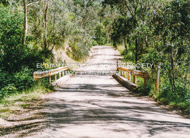
 Eltham District Historical Society Inc
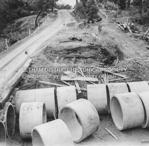
Album - Photograph, J.A. McDonald, Heidelberg-Kinglake Road, c. 1956
Bridge over Cherry Tree Gully demolished Pipes in place c. 1956Record of various Shire of Eltham infrastructure works undertaken during the period of 1952-1962 involving bridge and road reconstruction projects, sometimes with Eltham Shire Council Project Reference numbers quoted. It was during this period that a number of significant improvements were made to roads and new bridges constructed within the shire that remain in place as of present day (2022). In many situations, the photos provide a tangible visible record of infrastructure that existed throughout the early days of the Shire. The album was put together by or under the direction of the Shire Engineer, J.A. McDonald.infrastructure, shire of eltham, 1956, bridge construction, heidelberg-kinglake road, road construction, cherry tree gully -
 Eltham District Historical Society Inc
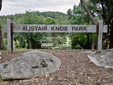
Photograph, Jim Connor, Alistair Knox Park, 14 Jan 2017
It’s hard to believe, as look at Alistair Knox Park, that this whole area was a tip in the 1960s. Although now valued as a natural attraction, the hills and lake are human made, with the hills built on mounds of rubbish. School children planted many of the trees. Many of the large eucalypt trees are remanent of the original bushland. The park has a National Trust Landscape Classification. It was close to this location that the Eltham Obelsik was originally located in 1919 and had to be relocated when roadworks were undertaken to widen the intersection. The park is named for Knox who was a local designer, builder and advocate for an alternative lifestyle, best known for use of mudbricks. Tomorrow's history documented todayeltham, jim connor collection, main road, eltham gateway, alistair knox park -
 Eltham District Historical Society Inc
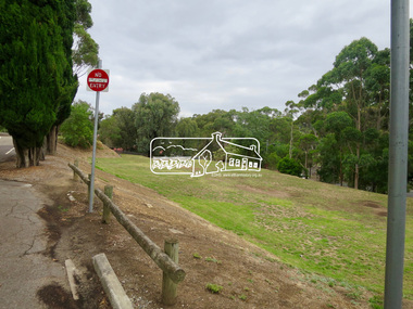
Photograph, Jim Connor, Main Road, Eltham, 14 Jan 2017
Eltham Gateway, Site of the former Eltham Shire Council offices at 895 Main Road, Eltham Demolished by State Government appoointed Commisoners in August 1996, the site was the original location of Shillinglaw Cottage which was acquired by Eltham Shire in 1963. The Council offices were builty in 1964. A community driven fundraising campain led to the rescu of Shillinglaw Cottage from demolition and it was relocated with Council assistance to its present location a few hundred metres away.Tomorrow's history documented todayeltham, jim connor collection, main road, eltham gateway, 895 main road, shillinglaw trees -
 Eltham District Historical Society Inc
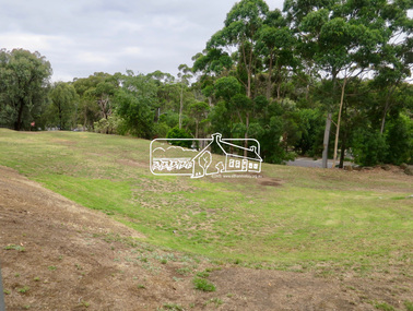
Photograph, Jim Connor, Main Road, Eltham, 14 Jan 2017
Eltham Gateway, Site of the former Eltham Shire Council offices at 895 Main Road, Eltham Demolished by State Government appoointed Commisoners in August 1996, the site was the original location of Shillinglaw Cottage which was acquired by Eltham Shire in 1963. The Council offices were builty in 1964. A community driven fundraising campain led to the rescu of Shillinglaw Cottage from demolition and it was relocated with Council assistance to its present location a few hundred metres away.Tomorrow's history documented todayeltham, jim connor collection, main road, eltham gateway, 895 main road, shillinglaw trees -
 Eltham District Historical Society Inc
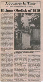
Folder, Eltham Obelisk (later Cenotaph), 1918-2018
The Eltham Obelisk was originally located at the corner of Bridge and Main Roads in 1919. In 1943 (WW2) the local community commenced plans to establish the Eltham War Memorial, a living memorial to benefit the children as opposed to a one in stone as per the obelisk. The Eltham War Memorial Trust was established in 1945. In 1947 the Trust intended for the Obelisk to be relocated from Bridge Street and Main Road to the Garden of Remembrance which was planned as part of the Baby Health Centre which was to be the first of three buildings of the Eltham War Memorial to be built in 1951. In 1951 the Eltham RSL was invited to be represented on the Eltham War Memorial Trust. Around this time, with pending roadworks, the obelisk was relocated to the front garden of the Eltham RSL sub branch on Main Road for safe keeping. In 2007, a suggestion was proposed by Harry Gilham (President, EDHS) to John Cohen (ERSL) to claim a special site along with the historic Shillinglaw trees on the now vacant former Eltham Shire Office site adjacent to the Eltham War Memorial precinct for relocation of the obelisk. In 2010 following the financial collapse and sale of the Eltham RSL Sub-Branch property and amalgamation with the Montmorency Eltham RSL sub-branch, the location of the obelisk was again in immediate jepoardy and in conjunction with Nillumbik Shire Council, the obelisk was relocated in front of the Eltham War Memorial buildings in preparation for the Dawn Service on Anzac Day 2012. Contents: Newspaper article: Eltham Obelisk of 1919, Harry Gilham, August 2000 as well as draft submitted dated 22 Aug 2000 Newspaper article: Eltham, The Advertiser 15 Nov 1918 and 18 Nov 1918 Newspaper article: An Obelisk at Eltham, The Advertiser, 11 Jul 1919 Newspaper advertisement: Unveiling of Obelisk at Eltham, The Advertiser, 1 Aug 1919 Newspaper article: Eltham Soldiers’ Memorial; Unveiled by Sir William Irvine, The Argus, Monday, 4 Aug 1919, p8 Newspaper article: Eltham Memorial to Fallen Soldiers, Diamond Creek Valley Advocate, 8 Aug 1919 Newspaper article: Memorial to the Fallen; Unveiled at Eltham, The Age, Monday, 4th August 1919 Newspaper article: Programme - Presentation of German Machine Gun at the Obelisk, Eltham on Sunday, 8th August, 1920, at 3.30 P.M. Newspaper article: article about presentation of a war trophy, a heavy machine gun placed beside obelisk, The Advertiser, 13 Aug 1920 Newspaper article: Eltham: ANZAC Services, The Advertiser, Friday, May 2, 1924 Newspaper article: Eltham War Memorial, The Advertiser, Oct 26, 1928 Handwritten note from Harry Gilham (President EDHS) to John Cohen (ERSL) regarding history of Eltham RSL site and 1947 newspaper article "Eltham War Memorial Trust "Garden of Remembrance" referencing relocation of Obelisk to the proposed Garden of Remembrance at the Baby Health Centre (Eltham War Memorial). Officers' reports, 11.113/10 Relocation of Eltham RSL Cenotaph, Nillumbik Shire Council Ordinary Meeting, 21 December 2010 Email Correspondence: EDHS President to NSC General Manager Community and Leisure re RSL Obelisk (Cenotaph) proposed relocation, 24 May 2011 Newsletter Extract: Eltham RSL and War Memorial, EDHS Newsletter 14 Sep 2011 Officers' reports, OCM.091/11 Interim Relocation site for the Eltham Cenotaph, Nillumbik Shire Council Ordinary Meeting, 23 August 2011 Officers' reports, OCM.004/121 Interim Relocation of the Eltham Cenotaph, Nillumbik Shire Council Ordinary Meeting, 31 January 2012 (includes Funding agreement between NSC and Montmorency-Eltham RSL Sub-branch Inc) Newspaper article: Move war memorial: RSL, c.2011 Newspaper article: Memorial move lags, Diamond Valley Leader, 1 February 2012 Newspaper article: New dawn for tribute, Diamond Valley Leader ca April 2012 Open letter to the residents of Eltham and Montmorency and copies of drafts by the Montmorency Eltham RSL, no date and final version published in Diamond Valley New 21 March 2012 and Banyule & Nillumbik Weekly, 27 March, 2012 Newspaper article: RSL site nets $1.8m, Diamond Valley Leader, 9 May 2012 Newspaper article: Memorial Moved, Banyule/Nillumbik Weekly, 10 April 2012 Newspaper article: Eltham cenotaph move goes 'like clockwork', Diamond Valley Leader, 11 April 2012 Advertisement, Program for Eltham Dawn Service, Diamond Valley Leader, April 2012 Newspaper photo: Veterans (l-r) Alan Field, Max Lowerson and John Cohen will join piper David Cretney to commemorate fallen Diggers, 2012 (standing beside relocated obelisk in front of the Eltham War Memorial complex) Program for Montmorency Anzac Day March 2012 (incomplete, some pages duplicated, some pages upside down). Newspaper article: Plan to expand memorial, Diamond Valley Leader, Sep. 2004, p5 Newspaper article: Names renewal, thanks to Barry, Diamond Valley Leader, 18 Apr 2007, p3 with picture featuring Eltham RSL president John Haines and Gwen Rosewall Letter: EDHS President to Manager Community Participation, Learning and Culture, Nillumbik Shire Council regarding a proposal by the Montmorency-Eltham RSL Sub-branch to expand the area occupied by the relocated obelisk further into the Eltham War Memorial Garden of Remembrance, 18 Aug 2014 Notices of Motion, NOM.001/14 pertaining to memorials Advisory Committee and Montmorency-Eltham RSL to upgrade the Eltham War Memorial site in time for ANZAC Day 2015, Nillumbik Shire Council Ordinary Meeting, 26 August 2014 Agenda: User Groups and Stakeholders Meeting, Proposed Extension to Memorial Terrace, 11 September 2014 EDHS presentation to NSC Policy and Services meeting 9 September 2014 regarding the Montmorency-Eltham RSL proposal to expand/upgrade the Eltham War Memorial Policy and Services reports, PSD.034/14 Eltham War Memorial Building Precinct - Proposed Extension to Memorial Terrace, Nillumbik Shire Council Ordinary Meeting, 9 September 2014 Email (copy): President EDHS re Eltham War Memorial Complex, Main Road, Eltham, 15 Sep 2014 requesting Nillumbik Shire Council place a Heritage Overlay upon the Eltham War Memorial Complex Media Release: Support for cenotaph expansion, Nillumbik Shire Council, Sep 2014 Newspaper article: Council defers RSL war memorial upgrade to see consultation, Diamond Valley News, 17 Sep 2014 Letter (copy): Harry Gilham, Eltham to local press and others, 20 Sep 2014 protesting attempts by the RSL to further expand upon the area already ceded from the Eltham War Memorial for the relocated WW1 obelisk and alter the original vision for an Eltham War Memorial complex. Letter: Alan Field, President, The Eltham Veterans War Memorial Preservation Society Inc. to CEO and Councillors, Nillumbik Shire Council protesting at perceived injustices and ‘veteran bashing’ regarding their previous efforts to relocate ‘their Obelisk and Cenotaph’ to the Eltham War Memorial complex and their frustration in their attempts to further expand upon the Memorial Terrace. Areas of letter are highlighted with handwritten markups and notes. Also notes on loose card and paper with definitions of Memorial, Obelisk, Cenotaph, commentary on establishment of Eltham War Memorial, The Eltham War Memorial Trust and RSL involvement and current actions by RSL in respect to claims in the letter (written by Harry Gilham ?). Policy and Services reports, PS.038/14 Eltham War Memorial Building Precinct - proposed extension to the Eltham Cenotaph Terrace, Nillumbik Shire Council Policy and Services Committee Meeting, 14 October 2014 Newspaper article: Centenary dawn service moves to Petrie Park, Diamond Valley Leader, 22 Oct 2014 Newspaper article: Upset over upgrade; war memorial revamp plans get culled, Diamond Valley Leader, 29 Oct 2014 Newspaper article: Memories of our heroes, Diamond Valley Leader, 25 Apr 2018 – also Veteran saluted, featuring article on Army veteran, Glen Ferrarotto. Handwritten notes in pencil (2 pages) by Harry Gilham, Items form the Eltham and Whittlesea Shires The Advertiser newspaper 7 June 1918 - 1919 providing a summary of the formation of the Peace Celebration Committee leading to the establishment of the Avenue of Honour and the Eltham Obeliskeltham cenotaph, nillumbik shire council, eltham war memorial, montmorency eltham rsl sub-branch, dawn service, cenotaph, eltham rsl sub-branch, eltham war memorial trust, garden of remembrance, harry gilham collection, john cohen, obelisk, remembrance garden, shillinglaw trees, german machine gun, war memorial, war trophy -
 Eltham District Historical Society Inc
Folder, Victorian Goldfields Project: Historic gold mining sites in St Andrews mining division, 1999
Heritage site report and gazetteer by David Bannear, head consultant for archealogy for the Department of Natural Resources and Environment. Includes information on the Warrandyte Goldfield and the Caledonia Goldfield, Queenstown (now known as St Andrews), One Tree Hill, Kingston (now known as Panton Hill), Kangaroo Grounds, You You Hill, Kingstown, South Morang, Nillumbik, (now known as Diamond Creek), Steele's Creek, Yarrambet and Kinglake. Photocopy of map headed: Location of mines and reefs from Geological survey of Victoria, Yan Yean with the Diamond Creek prominant on the map. no date35 page report with map and print out of cover letter (email form) from donorcaledonian gold fields, caledonina gold field, david bannear, gold mining, harry gilham collection, queenstown, st andrews, warrandyte goldfield -
 Bendigo Military Museum
Photograph - PHOTOGRAPH, FRAMED, possibly between the two World Wars
... . Trees in background. Location unknown. ... & boots. Trees in background. Location unknown. Photograph ...Black & white photo of unknown battalion with band & instruments in front line. Members are wearing puttees & boots. Trees in background. Location unknown. RHS bottom corner: "Walker Photo"photography-photographs, military history-army -
 Federation University Historical Collection
Document - Document - Letter, VIOSH: University of Ballarat; "Growing and Sharing the OHS Knowledge" - 25 years Celebration, 2004
Victorian Institute of Occupational Safety and Health (VIOSH) Australia is the Asia-Pacific centre for teaching and research in occupational health and safety (OHS) and is known as one of Australia's leaders on the field. VIOSH has a global reputation for its innovative approach within the field of OHS management. VIOSH had its first intake of students in 1979. At that time the Institution was known as the Ballarat College of Advanced Education. In 1990 it became known as Ballarat University College, then in 1994 as University of Ballarat. It was 2014 that it became Federation University. VIOSH Australia students are safety managers, senior advisors and experienced OHS professionals. They come from all over Australia and industry. Students are taught active research and enquiry; rather than textbook learning and a one-size fits all approach. VIOSH accepts people into the Graduate Diploma of Occupational Hazard Management who have no undergraduate degree - on the basis of extensive work experience and knowledge. Letter gives the history of the "Big Tree" at the heart of the University of Ballarat, Mount Helen. The seedling was planted in 1896 by Mrs Elizabeth Downing who lived on what was their farm. The land was purchased in 1966 as part of a site for the location of the new campus It was decided that the tree should remain as a central landmark.Letter typed on cream flecked paper - A4 size. Image of tree A4 card, folded into three, deep burgundy. Letter attached with small packet of seeds. These have been removed.viosh, victorian institute of occupational safety and health, university of ballarat, mount helen, big tree, elizabeth downing, 1896, 1966 -
 Mission to Seafarers Victoria
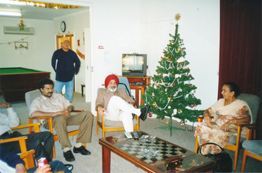
Photograph, Seafarers during Christmas time in the Hastings Seafarer Centre, Late 20th Century or early 21st
Christmas time at sea has traditionally been a key focus of Mission services to seafarers. It has also been a location where family members or friends can meet up briefly. This image was taken at the Hastings Mission to Seafarers.Part of a collection of Hasting Memorabilia collected by Keith and Pat Dann over a number of years. Prior to helping set up Hastings mission Keith Dann was also an active member at 717 Flinders St Mission.small colour photograph depicting decorated Christmas tree two seated and one standing seafarer. Also an older Sikh gentleman and his wife, possibly related to one of the seafarers. A chess and draughts confutable in foreground. christmas, hastings mission, keith dann, pat dann, pool table, television -
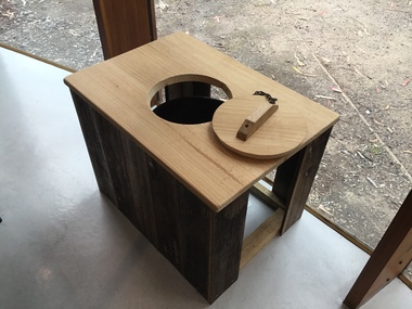 Lorne Historical Society
Functional object - Thunderbox, Circa 1930’s
The Great Ocean Road was built by World War 1 returned servicemen. Tolls were collected as sections of the road were completed. The first toll house was at Grassy Creek. It operated from 1922 to 1932 when it was moved to The Springs at Cathedral Rock about 5 km east of Lorne. The thunderbox is believed to have been used here at sometime between 1932 and 1936This is a rare archeological find. Items n this location are often damaged by the action of the sea and salt air. It is intimately associated with the early years of the development of the Great Ocean Road and the daily life of the workers. It is a typical example of the type of toilet used at the time. This reclaimed timber thunder box is enclosed on three sides. There is a circular hole on the top with a wooden handled lid attached by a chain. Inside is a steel can.great ocean road construction, returned sevicemen world war 1, great ocean road toll houses, toilet -
 Greensborough Historical Society
Genealogical Document, Michael Butler and family, 2017_
Michael Butler and his family are recorded as living on the Plenty River in 1840. Later records and Titles give the address as Clear Hills near Greensborough. The location appears to be in Plenty.17 pages, including family tree and copies of titlesbutler family, michael butler, clear hills, plenty -
 Glenelg Shire Council Cultural Collection
Photograph - Photograph - Rural scene, n.d
... . Image shows a rural scene, stream, reeds, bare trees... shows a rural scene, stream, reeds, bare trees of an unknown ...Black and white photo mounted on heavy dark grey card. Image shows a rural scene, stream, reeds, bare trees of an unknown location.Back: 'View near Portland' - black pen. 'largo/fargo class 1 (all crossed out, black pen) -
 Halls Gap & Grampians Historical Society
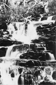
Photograph - B/W
Location and women not identified.The photo shows two young women, at the top of the picture, beside a cascading waterfall. A large, twisted, leafless branch of a tree extends out over the main drop of the falls.scenery, waterfalls -
 Halls Gap & Grampians Historical Society
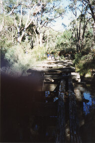
Photograph - Coloured, C 1980s
This is a photo of one of the trestle bridges on the Heatherlie Quarry train line. The bridge is located near the current location of "The Pines" campground.The photo is a "front on" of a derelict trestle bridge crossing a shallow creek; many sleepers are missing and thick bush and trees surround the bridge. There are four adults at the end of the bridge, one standing and three seatede. The bottom left hand side of the photo is blurredstructures, bridges, quarrying, heatherlie -
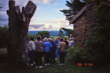
 Eltham District Historical Society Inc
Photograph, Edendale Farm, Eltham Heritage Tour, 24 May 1992, 24/05/1992
ELTHAM HERITAGE TOUR The Society excursion on 24th May 1992 was arranged by David Bick, leader of the team carrying out the Shire's heritage study. David selected a number of sites or buildings identified in the study, some of them lesser known components of the Shire's heritage. The tour commenced at the Eltham Shire Office at 10.00 am. Travel was by private car and mini-bus with stops at about twelve locations for commentary by David.It included a short walk in Hurstbridge and lunch at Kinglake. Highlights of the tour included: - 10 am Leave from Shire Offices - 3 Important Trees - A Physical Link to Eltham's First Settlers - Toorak Mansion Gates - A Surviving Farm House - An Intact Circa 1900 Main Street - First Settlers - Gold Miners, and Timber-getters - An Early Hotel - A Pioneering Homestead - Changing Eltham Shire - 20th Century - 4 pm Afternoon Tea and Finish Tour Extract from ELTHAM CULTURAL HERITAGE TOUR (Newsletter No. 85, July 1992, by Bettina Woodburn) "The land was unprofitable for intensive farming, but there was always water in the Diamond Creek. The railway, a technological advance, followed the valley, and was provided to transport produce. At North Eltham we were privileged to tour a surviving farmhouse of the 1860-70 era at the Shire’s Edendale Farm, with the as yet unfinished Sculpture for a front fence - bulbous tree-trunks decorated with salt pots, with cross members from the old trestle bridge. As was usual these six veranda posted houses faced South (or East, away from the sun!) with the scullery, kitchen and pantry "out the back". The veranda, which must have been very narrow, no longer exists. It probably wrapped around three sides. The drive took us past the Dutch Windmill, only twenty years old and in the Shire of Diamond Valley, then the Diamond Creek Cemetery with impressive gateway, to a detour to see another old farmhouse, isolated on a hill off Murray Road Wattle Glen. Here was a particularly thick patch of exotic planting of pines and cypresses. Subsistence farming no longer pays. Following the rail-line we noticed on the left near Silvan Road an Edwardian cottage and on the right near Yates Road the old school residence for this Upper Diamond Creek area."Record of the Society's history and activities and highlighting various aspects of the Heritage Study undertaken by David Bick used to create the future heritage overlay for the Shire of Eltham and later Nillumbik Shire.Roll of 35mm colour negative film, 4 stripsKodak Gold 100 5095eltham, shire of eltham historical society, activities, heritage tour -
 Eltham District Historical Society Inc
Photograph, Allwood House, Hurstbridge, Eltham Heritage Tour, 24 May 1992, 24/05/1992
ELTHAM HERITAGE TOUR The Society excursion on 24th May 1992 was arranged by David Bick, leader of the team carrying out the Shire's heritage study. David selected a number of sites or buildings identified in the study, some of them lesser known components of the Shire's heritage. The tour commenced at the Eltham Shire Office at 10.00 am. Travel was by private car and mini-bus with stops at about twelve locations for commentary by David.It included a short walk in Hurstbridge and lunch at Kinglake. Highlights of the tour included: - 10 am Leave from Shire Offices - 3 Important Trees - A Physical Link to Eltham's First Settlers - Toorak Mansion Gates - A Surviving Farm House - An Intact Circa 1900 Main Street - First Settlers - Gold Miners, and Timber-getters - An Early Hotel - A Pioneering Homestead - Changing Eltham Shire - 20th Century - 4 pm Afternoon Tea and Finish Tour Extract from ELTHAM CULTURAL HERITAGE TOUR (Newsletter No. 85, July 1992, by Bettina Woodburn) "At the crossroads stands Allwood House with its well laid out garden. The original owners, the Hurst family, ran a nursery; the aligned palms, the cactus clumps, the introduced trees and shrubs show the plants then in fashion. On the other corners stand an old corrugated iron garage; a restaurant, designed and built 1980, but by using old materials it tries to retain the rustic character of its surroundings; and open space where a two storied Wineshop/Saloon once stood. The old Bank, now in the grounds of Allwood House has been moved a few doors down the street."Record of the Society's history and activities and highlighting various aspects of the Heritage Study undertaken by David Bick used to create the future heritage overlay for the Shire of Eltham and later Nillumbik Shire.Roll of 35mm colour negative film, 4 stripsKodak Gold 100 5095shire of eltham historical society, activities, heritage tour, hurstbridge, allwood house -
 Eltham District Historical Society Inc
Photograph, Kangaroo Ground War Memorial, Eltham Heritage Tour, 24 May 1992, 24/05/1992
ELTHAM HERITAGE TOUR The Society excursion on 24th May 1992 was arranged by David Bick, leader of the team carrying out the Shire's heritage study. David selected a number of sites or buildings identified in the study, some of them lesser known components of the Shire's heritage. The tour commenced at the Eltham Shire Office at 10.00 am. Travel was by private car and mini-bus with stops at about twelve locations for commentary by David.It included a short walk in Hurstbridge and lunch at Kinglake. Highlights of the tour included: - 10 am Leave from Shire Offices - 3 Important Trees - A Physical Link to Eltham's First Settlers - Toorak Mansion Gates - A Surviving Farm House - An Intact Circa 1900 Main Street - First Settlers - Gold Miners, and Timber-getters - An Early Hotel - A Pioneering Homestead - Changing Eltham Shire - 20th Century - 4 pm Afternoon Tea and Finish Tour Extract from ELTHAM CULTURAL HERITAGE TOUR (Newsletter No. 85, July 1992, by Bettina Woodburn) "Now we drove through stands of pines to the Kangaroo Ground Lookout Tower, a most unusual War Memorial, World War I. The tower and a shed/residence (it had a chimney) were built from local sandstone. Below to the south and east of Melbourne spread 'suburbia'. Close by the landscape seemed so contrived - English fields and hedgerows! Although only about twenty inches deep, the soil of this ancient volcano, its crater lost under subsequent weathering, was rich, deserving the name of "Garden Hill". Now native trees are taking over again. In Kangaroo Ground itself stand the inevitable Store, School and Church - and two Norfolk pines and a monkey puzzle tree."Record of the Society's history and activities and highlighting various aspects of the Heritage Study undertaken by David Bick used to create the future heritage overlay for the Shire of Eltham and later Nillumbik Shire.Roll of 35mm colour negative film, 4 stripsKodak Gold 100 5095shire of eltham historical society, activities, heritage tour, kangaroo ground, kangaroo ground tower, war memorials, kangaroo ground memorial -
 Eltham District Historical Society Inc
Photograph, Shire of Eltham War Memorial, Memorial Park, Garden Hill, Kangaroo Ground; Eltham Heritage Tour, 24 May 1992, 24/05/1992
ELTHAM HERITAGE TOUR The Society excursion on 24th May 1992 was arranged by David Bick, leader of the team carrying out the Shire's heritage study. David selected a number of sites or buildings identified in the study, some of them lesser known components of the Shire's heritage. The tour commenced at the Eltham Shire Office at 10.00 am. Travel was by private car and mini-bus with stops at about twelve locations for commentary by David.It included a short walk in Hurstbridge and lunch at Kinglake. Highlights of the tour included: - 10 am Leave from Shire Offices - 3 Important Trees - A Physical Link to Eltham's First Settlers - Toorak Mansion Gates - A Surviving Farm House - An Intact Circa 1900 Main Street - First Settlers - Gold Miners, and Timber-getters - An Early Hotel - A Pioneering Homestead - Changing Eltham Shire - 20th Century - 4 pm Afternoon Tea and Finish Tour Extract from ELTHAM CULTURAL HERITAGE TOUR (Newsletter No. 85, July 1992, by Bettina Woodburn) "Now we drove through stands of pines to the Kangaroo Ground Lookout Tower, a most unusual War Memorial, World War I. The tower and a shed/residence (it had a chimney) were built from local sandstone. Below to the south and east of Melbourne spread 'suburbia'. Close by the landscape seemed so contrived - English fields and hedgerows! Although only about twenty inches deep, the soil of this ancient volcano, its crater lost under subsequent weathering, was rich, deserving the name of "Garden Hill". Now native trees are taking over again. In Kangaroo Ground itself stand the inevitable Store, School and Church - and two Norfolk pines and a monkey puzzle tree." On November 11th 1926 the Shire of Eltham War Memorial Tower at Kangaroo Ground was opened. It is regarded as one of Melbourne’s most outstanding lookout towers. It commands a magnificent 360 degree panorama from Kinglake across the Diamond Valley to Macedon and the You Yangs. It is built on a peak which was once a volcano, 237 metres above sea level. After World War one a memorial cairn was erected on the site, and in 1925 a committee of public-minded citizens began to plan for a tower. Many generous donations of material and money were forthcoming so that in 1926 the Governor General Lord Stonehaven was able to unveil the plaque before a crowd of 500 people. There was some concern in the 1960s when the Forests Commission wanted to build a firespotters cabin on the top. At first R.S.L. branches opposed the idea, but it was realised that this use could combine with its use as a tourist attraction, and would ensure its maintenance for the future, Today the Kangaroo Ground tower provides one of the best views around Melbourne and is a fitting memorial to those who died in two world wars. From: Historic items for Diamond Valley Community Radio September 1990 (EDHS collection) Record of the Society's history and activities and highlighting various aspects of the Heritage Study undertaken by David Bick used to create the future heritage overlay for the Shire of Eltham and later Nillumbik Shire.Roll of 35mm colour negative film, 4 stripsKodak Gold 100 5095culture, events, garden hill, kangaroo ground, kangaroo ground memorial, memorial park, shire of eltham war memorial tower, war memorials -
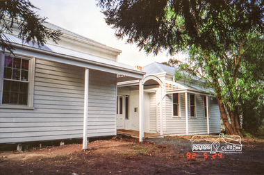
 Eltham District Historical Society Inc
Photograph, John Collins, Shillinglaw Cottage on its original site, 17 Oct. 1963
Shilinglaw Cottage in its original location on Main Road Eltham with the “Shillllinglaw trees”. This image was taken shortly before its relocation. Believed to be have been taken by John Collins, 17 Oct 1963 as per other images held by the State Library of Victoria Author / Creator: John T Collins 1907-2001 , photographer. J.T. Collins Collection, La Trobe Picture Collection, State Library of Victoria. Shillinglaw Cottage is significant to Eltham’s local history. It is one of the earliest known buildings still in existence. Records suggest that the cottage was built circa 1859 by a man named Cochrane, believed to be Thomas Cochrane, in conjunction with George Stebbings though it is not known what Stebbings’s contribution was. It is made from hand made bricks laid in a Flemish bond pattern. In the 1960s it was marked for demolition to make way for the construction of new council buildings but a community campaign saved the cottage and it was re-located. It is believed Stebbings owned the cottage between 1874 and 1888. According to Margaret Ball’s (2017) book Shillinglaw Family of Eltham 1660-2007, Thomas Cochrane and family lived there from 1867 to 1874 however this is contrary to the records of assessable rates levied by the Eltham District Road Board, established in 1858, which shows Cochrane was the owner occupier (in Little Eltham) of approximately 25 acres of cultivated land and 25 acres of pastureland upon which a hut was sited in 1860. It is suspected that George Stebbings may have acquired the property from Cochrane in 1874 as it is noted that he had a tenant for a period, James Rossiter, who was the editor for the Evelyn Observer in Kangaroo Ground in 1874 (LATE SHIRE OFFICE AT KANGAROO GROUND (1934, February 16). Advertiser (Hurstbridge, Vic. : 1922 - 1939), p. 5. Retrieved February 25, 2022, from http://nla.gov.au/nla.news-article56743657). In 1881 Phillip Shillinglaw became the ratepayer for the cottage though Stebbings retained ownership until 1888 at which time it was transferred to Shillinglaw. This photo forms part of a collection of photographs gathered by the Shire of Eltham for their centenary project book, "Pioneers and Painters: 100 years of the Shire of Eltham" by Alan Marshall (1971). The collection of over 500 images is held in partnership between Eltham District Historical Society and Yarra Plenty Regional Library (Eltham Library) and is now formally known as 'The Shire of Eltham Pioneers Photograph Collection.' It is significant in being the first community sourced collection representing the places and people of the Shire's first one hundred years.Digital image 4 x 5 inch B&W Negsepp, shire of eltham pioneers photograph collection, eltham, shillinglaw cottage, shillinglaw trees, significant tree -
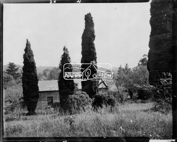 Eltham District Historical Society Inc
Negative - Photograph, Shillinglaw Cottage, 17 Oct. 1963
Shilinglaw Cottage in its original location on Main Road Eltham with the three Mediterranean Cypress trees (“Shillllinglaw trees”) in the garden. Note a fourth pine to the right. This image was taken shortly before its relocation. Believed to be have been taken by John Collins, 17 Oct 1963 as per other images held by the State Library of Victoria Author / Creator: John T Collins 1907-2001 , photographer. J.T. Collins Collection, La Trobe Picture Collection, State Library of Victoria. Shillinglaw Cottage is significant to Eltham’s local history. It is one of the earliest known buildings still in existence. Records suggest that the cottage was built circa 1859 by a man named Cochrane, believed to be Thomas Cochrane, in conjunction with George Stebbings though it is not known what Stebbings’s contribution was. It is made from hand made bricks laid in a Flemish bond pattern. In the 1960s it was marked for demolition to make way for the construction of new council buildings but a community campaign saved the cottage and it was re-located. It is believed Stebbings owned the cottage between 1874 and 1888. According to Margaret Ball’s (2017) book Shillinglaw Family of Eltham 1660-2007, Thomas Cochrane and family lived there from 1867 to 1874 however this is contrary to the records of assessable rates levied by the Eltham District Road Board, established in 1858, which shows Cochrane was the owner occupier (in Little Eltham) of approximately 25 acres of cultivated land and 25 acres of pastureland upon which a hut was sited in 1860. It is suspected that George Stebbings may have acquired the property from Cochrane in 1874 as it is noted that he had a tenant for a period, James Rossiter, who was the editor for the Evelyn Observer in Kangaroo Ground in 1874 (LATE SHIRE OFFICE AT KANGAROO GROUND (1934, February 16). Advertiser (Hurstbridge, Vic. : 1922 - 1939), p. 5. Retrieved February 25, 2022, from http://nla.gov.au/nla.news-article56743657). In 1881 Phillip Shillinglaw became the ratepayer for the cottage though Stebbings retained ownership until 1888 at which time it was transferred to Shillinglaw.Shillinglaw Cottage is itself historically, aesthetically and socially significant to the Shire of Nillumbik and is registered on the Victorian Heritage Database. This photo forms part of a collection of photographs gathered by the Shire of Eltham for their centenary project book, "Pioneers and Painters: 100 years of the Shire of Eltham" by Alan Marshall (1971). The collection of over 500 images is held in partnership between Eltham District Historical Society and Yarra Plenty Regional Library (Eltham Library) and is now formally known as 'The Shire of Eltham Pioneers Photograph Collection.' It is significant in being the first community sourced collection representing the places and people of the Shire's first one hundred years.Digital image 4 x 5 inch B&W Negsepp, shire of eltham pioneers photograph collection, eltham, shillinglaw cottage, significant tree -
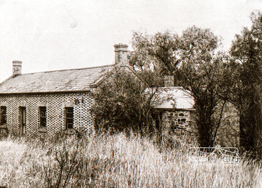 Eltham District Historical Society Inc
Photograph, Shillinglaw Cottage
... trees in its original location. Shillinglaw Cottage... trees in its original location. Shillinglaw Cottage ...Photograph of print of Shillinglaw cottage with three pine trees in its original location. Shillinglaw Cottage was to be demolished to make way for new Shire of Eltham offices but local community rallying saw the cottage saved and relocated brick by brick to its new location nearby in Panther Place.Roll of 35mm black and white negative film, 1 strip (2 frames)Fuji NP SSeltham, main road, shillinglaw cottage -
 Eltham District Historical Society Inc
Photograph, Doug Orford, Bridge across Watsons Creek, One Tree Hill Road, Christmas Hills, 1991, 1991
From a collection of 35 photos taken by Doug Orford at 35 specific locations along the exact boundary of the then Shire of Eltham.Colour photographwatsons creek, christmas hills, bridges, one tree hill road -
 Kiewa Valley Historical Society
Photograph of Kiewa Valley Pioneer Family, Three Generations of Kiewa Valley Pioneer Family (Coopers), late 1900s'
This historical family photograph spans three generations of the Cooper Family, a pioneer family, still residing in the Kiewa Valley. The large axe held by Pat was a handy tool for pioneer families to chop down trees for land clearing, building sheds and fences, outhouses and fire wood. This photograph was taken during a time where both male and females did some heavy lifting and processing. The rural sector at this point in time was physically a hard location for both sexes. The segregation of the sexes into specific job categories was some times non existent although household "chores" was in the main a woman's domain. The rural sector was in this point of time one which women were highly respected and the unwritten law of providing "assistance" and "reverence" by men in such actions as, socially opening doors, tipping the cap, offering a sturdy arm for support and refraining from doing or saying anything "uncouth" in a woman's presence. It was in a time when women's liberation was just starting to grow strength. Rural areas, on the hole, took longer to interfuse "city" hatched norms of behaviour. This photograph of a pioneer family still residing in the Kiewa Valley demonstrates not only the close protective environment that the valley has on all its inhabitants but also the close bonding that neighbors have towards each other. The term "God's gifted country" fits warmly with all the settlements in the valley. The relatively isolated (physically, visually and communications wise) has since post World War II been whittled away by faster and vastly improved communications with "the outside" world. The strength of commitment to the rural life can be seen in the faces of the family members in this photograph. The proud heritage is displayed without any external pressure. This large black and white family photograph is a reproduction on Fujicolor Crystal Archive Paper manufactured by Fujifilm. It is 200gsm matt finished paper with no borders. On the reverse side, written in pencil "Ted Cooper sitting aged 24-25, Pat Amery (Ted's youngest sister) holding Ted's eldest son Doug and Ted's father John Franklin Cooper(22-8-1892)"john cooper, ted cooper, pat amery, doug cooper, pioneer family kiewa valley -
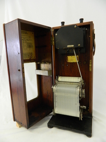 Kiewa Valley Historical Society
Meter Ammeter Recorder, Circa 1950
This testing voltmeter recorder was last certified by SEC Vic laboratories on the 17/4/77. It was used extensively as mobile recorder placed for periods of one month at locations experiencing unacceptable fluctuations of power. These locations would cover the North East regions of Victoria. They cover voltage drops at domestic and business properties especially those that were experiencing regular fluctuations(daily) at approximately the same time of the day. As the electrical network is required to operate within a set level of voltage, fluctuations outside of this has to be investigated and necessary remedial action taken. This is especially so for rural properties where power "drainage" can occur through animal/bird and tree interference. It can also be the result of defective wiring and overloading at peek operational times (milking machines).This mobile voltage recorder is very significant to the Kiewa Valley because it highlights the difficulties that can occur in maintaining a power supply that experiences fluctuating power demands by the rural industries that it supplies. The requirement of a mobile testing apparatus to cover the various sections in the Kiewa Valley and other rural areas in the northeast region is one of necessity as electricity once connected to a rural property is a labour saving supply as generators on rural properties require a higher degree of maintenance an ultimately at a higher cost. The testing of the SEC Vic supplied electricity to rural properties,those who had previously run on generators, had to be quick and unassuming with certainty of correct supply levels.The mechanism of this voltage recorder has been installed(by the manufacturer) into its own protective wooden box. This box has a front (swing open) lockable section which permits direct access to the installed measuring equipment (for servicing and data collection). The top section of the box has two screw on terminals for access to the machine being tested. This tester has its own inbuilt ink supply facilities and a mechanical clockwork device that unwinds a roll of paper onto a second roll at a rate of 10 mm per hour. The recording chart is marked with time slots against voltage. There is a recording arm which has an ink pen at the end. Both arm and pen carry the ink supply from the ink reservoir, located on the left side of the cabinet door in specially constructed bottle holder( three small bottle capacity). To record a suspect power problem to a home or business establishment the voltmeter is connected to a power supply outlet being tested and wind the recording clockwork mechanism (gives a four week running time). Before leaving the recorder in situ the electrician checks to see if the chart is recording the correct voltage and that the clock mechanism is advancing correctly.On the front of the access "door" at the top a metal label "RECORDING AMMETER" below this "MURDAY SYSTEM" below this "ALTERNATING CURRENT" and below this the manufacturer's registered number "No. 139156" Below this is a metal tag with State Electricity Commission of Victoria Electrical Engineer's Section equipment number "338" Below these tags and above the viewing window is the manufacturer's dtails "EVERSHED & VIGNOLES Led LONDON"sec vic kiewa hydro scheme, alternate energy supplies, alpine feasibility studies temperature, rainfall, power outages -
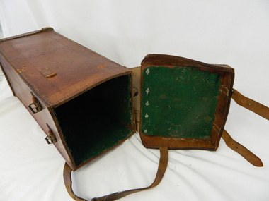 Kiewa Valley Historical Society
Case Volt Meter Recorder, Circa 1950 to 1977
This case is for a testing voltmeter recorder. The last time it was certified by SEC Vic laboratories on the 17/4/77. It was used extensively in the transportation of the mobile recorder which was sometimes placed for periods of one month at locations experiencing unacceptable fluctuations of power. These locations would cover the North East regions of Victoria. They cover voltage drops at domestic and business properties especially those that were experiencing regular fluctuations(daily) at approximately the same time of the day. As the electrical network is required to operate within a set level of voltage, fluctuations outside of this has to be investigated and necessary remedial action taken. This is especially so for rural properties where power "drainage" can occur through animal/bird and tree interference. See KVHS 0302 (A) for the instrument.This case for a mobile voltage recorder is very significant to the Kiewa Valley because it highlights the difficulties that can occur in maintaining a power supply that experiences fluctuating power demands by the rural industries that it supplies. The requirement of a mobile testing apparatus to cover the various sections in the Kiewa Valley and other rural areas in the northeast region is one of necessity as electricity once connected to a rural property is a labour saving supply as generators on rural properties require a higher degree of maintenance an ultimately at a higher cost. The testing of the SEC Vic supplied electricity to rural properties,those who had previously run on generators, had to be quick and unassuming with certainty of correct supply levels.This heavy and thick all leather case for the "easy" transportation of the Volt meter recorder has a opening top which pop riveted to the main body(rivets are aluminium). The all leather top has a shaped carrying handle which is also riveted on. There are two straps on the side of the top which can be fastened to the main body by metal "shoe" buckles. The bottom end is secured to the main bag by large rivets.Tick grade stitching is on all corners.Nilsec vic kiewa hydro scheme, alternate energy supplies, alpine growth in electricity consumption -
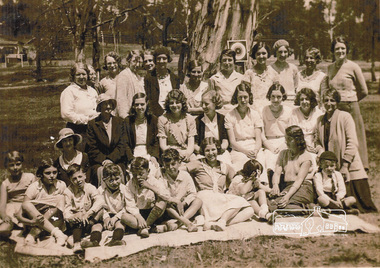
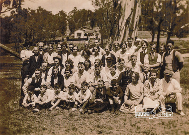 Eltham District Historical Society Inc
Photograph, Group from Brunswick ANA Lodge at Eltham, Nov. 1933
One of three photos. Group of people including children associated with the Australian Natives Association at an outing at Eltham Lower Park. The first image was reproduced in EDHS Newsletter No. 163 July 2005 following a query from Nillumbik Historical society (Gwen Myers) seeking information about the location of the photo. It was suggested that it may be Eltham Lower Park, however the house in the background did not appear correct. There were simliar but mirror imaged. A more recent review of these photographs (2023) suggests that the photos were actually taken in Bremners flats (present-day Wingrove Park) looking towards the house near the intersection of Main and Mount Pleasant roads - Mrs Bremner's house. The topograpghy is also more in fitting with this location than that of Eltham Lower Park. A review of a 1945 aerial photo shows only one house of similar style present in this location. Further reviews of photos taken in the 1950s by Grace Mitchell looking back towards Bremner Flats shows two trees close by on a lean similar to that in the photos.Inkjet-printed copy of sepia photographaustralian natives association, bremners flats, recruitment, wingrove park -
 Eltham District Historical Society Inc
Photograph, Group from Brunswick ANA Lodge at Eltham, Nov. 1933
One of three photos. Group of people including children associated with the Australian Natives Association at an outing at Eltham Lower Park. The first image was reproduced in EDHS Newsletter No. 163 July 2005 following a query from Nillumbik Historical society (Gwen Myers) seeking information about the location of the photo. It was suggested that it may be Eltham Lower Park, however the house in the background did not appear correct. There were simliar but mirror imaged. A more recent review of these photographs (2023) suggests that the photos were actually taken in Bremners flats (present-day Wingrove Park) looking towards the house near the intersection of Main and Mount Pleasant roads - Mrs Bremner's house. The topograpghy is also more in fitting with this location than that of Eltham Lower Park. A review of a 1945 aerial photo shows only one house of similar style present in this location. Further reviews of photos taken in the 1950s ny Grace Mitchell looking back towards Bremner Flats shows two trees close by on a lean similar to that in the photos.Inkjet-printed copy of sepia photographaustralian natives association, bremners flats, recruitment, wingrove park -
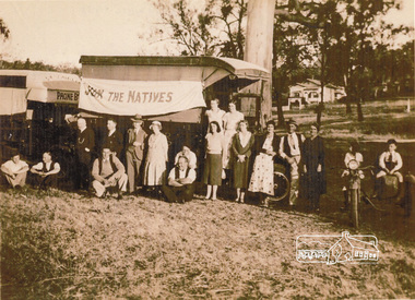 Eltham District Historical Society Inc
Photograph, Group from Brunswick ANA Lodge at Eltham, Nov. 1933
One of three photos. Group of people including children associated with the Australian Natives Association at an outing at Eltham. A truck displays a flag "Join the Natives". The first image was reproduced in EDHS Newsletter No. 163 July 2005 following a query from Nillumbik Historical society (Gwen Myers) seeking information about the location of the photo. It was suggested that it may be Eltham Lower Park, however the house in the background did not appear correct. There were simliar but mirror imaged. A more recent review of these photographs (2023) suggests that the photos were actually taken in Bremners flats (present-day Wingrove Park) looking towards the house near the intersection of Main and Mount Pleasant roads - Mrs Bremner's house. The topograpghy is also more in fitting with this location than that of Eltham Lower Park. A review of a 1945 aerial photo shows only one house of similar style present in this location. Further reviews of photos taken in the 1950s ny Grace Mitchell looking back towards Bremner Flats shows two trees close by on a lean similar to that in the photos. Inkjet-printed copy of sepia photographaustralian natives association, recruitment, bremners flats, wingrove park