Showing 268 items
matching mining box
-
 Ringwood and District Historical Society
Administrative record - Mining Reports, Government Printer, Melbourne, Colony of Victoria quarterly and annual mining reports - 1860s 1870s & 1880s, 1865 - 1883
Colony of Victoria mining reports show any Ringwood mine references under Castlemaine District, St. Andrews Subdivision. Noteworthy for Ringwood: - Death of Pierce Boardman, mining manager at New Ringwood Mining Co., accidentally killed when he lost his footing and fell to a depth of 40 feet on 1st January 1879. - William White injured in truck accident at New Ringwood Antimony Tribute Company, 31st March 1882.Boxed collection of soft and hard bound reports including: 1. Quarterly Colony of Victoria reports of the Mining Surveyors & Registrars, Victoria, 1865-1881 - Summary of gold mining statistics for the quarter - Tables showing the yield of gold from certain parcels of quartz raised during the quarter in some of the deepest mines in Victoria with depth of the deepest shafts, levels, cross-cuts, etc. - Estimated yield of gold and quantity of gold exported during the quarter - Gold received and issued from the Royal Mint during the quarter - Summary of yield of gold from quartz, tailings, etc., crushed during the quarter - Summary of yield of gold from washdirt and cement washed and crushed during quarter - Number and distribution of miners on the goldfields of the colony. 2. 1879-82 Hard bound volume - Chief Inspector of Mines Reports to the Honorable Minister of Mines, Victoria. (Includes fatal and non-fatal accident reports, mining operations, and employment statistcs.) Noteworthy for Ringwood: - Death of Pierce Boardman, mining manager at New Ringwood Mining Co., accidentally killed when he lost his footing and fell to a depth of 40 feet on 1st January 1879. - William White injured in truck accident at New Ringwood Antimony Tribute Company, 31st March 1882. 3. Mineral Statistics for Victoria - annual reports for years 1867, 1871, 1874, 1876, 1877, 1878, & 1879. 4. Handwritten study notes.antimony, boardman, william white -
Upper Yarra Museum
Food Safe, Untitled
http://museumvictoria.com.au/discoverycentre/infosheets/the-coolgardie-safe/ http://en.wikipedia.org/wiki/Coolgardie_safe The Coolgardie Safe is a low-tech refrigeration unit which uses the heat transfer which occurs during evaporation of water. It was named after the place where it was invented — the small mining town of Coolgardie, Western Australia, near Kalgoorlie-Boulder. http://www.biggles.com.au/ The Coolgardie Safe was simply a wire framed box with wheat sack strips hanging down the sides, which were kept wet by the process of osmosis from a dish or small tank of water. The food inside the Safe was kept cool due to the principle that evaporation takes away heat; the wet hessian strips experience evaporation from the wind and the sun and thus you have a refrigerator. http://www.whitehat.com.au/australia/Inventions/InventionsA.html Coolgardie Safe made from galvanised iron with hessian drapped over 4 sides, rectangular on 4 legs. 2 trays inside, 3rd tray inserted in top as cover, metal meshing on callapsable sides and door. Stands in tray. The tray assists with pest control as it was filled with water.kitchen galvanised iron coolgardie safe hessian food preservation pest control water -
 Marysville & District Historical Society
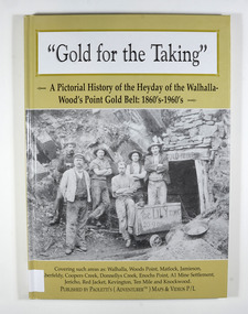
Book - Hardcover book, Gold for the Taking-A Pictorial History of the Heyday of the Walhalla-Wood's Point Gold Belt: 1860's-1960's, 2007
A pictorial history of the heyday of the Walhalla-Wood's Point gold belt in the 1860's-1960'sHardcover. The cover is a gold colour. The front cover has a photograph of a group of miners in front of the entry to a mine. On the top entry timber piece is a sign saying "Old Mine". The beginning of the wording is obscured by one of the miners standing in front of the entry. There is also an old mining trolley standing on tracks which lead into the mine.There is also an old gold mining dish sitting on a rock to the left of the entry into the mine.On the back cover is a photograph of Walhalla in modern times as well as a photograph of the publisher of this book. There is also a blurb about the publisher.Stamp of the Marysville & District Historical Society Inc / P.O. Box 22 / Marysville 3779gold, gold fields, gold mining, a1 mine settlement, aberfeldy, beardmore, black river group, coopers creek, donnellys creek, enochs point, fulton creek, gaffneys creek, gooleys creek, jamieson, jordan valley, kevington, knockwood, matlock, ten mile, walhalla, wood's point, history, victoria -
 Marysville & District Historical Society
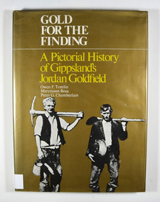
Book - Hardcover book, Gold for the Finding-A Pictorial History of Gippsland's Jordan Goldfield, 1979
A pictorial history of Gippsland's Jordan goldfieldHardcover. Gold dust cover. Front cover has a photograph of two miners carrying mining equipment.This work is dedicated to the people of the Jordan Goldfields,/ the Pioneers who worked, lived, loved and died in the moun-/ tains of Gippsland, giving us a rich and varied heritage. It is especially dedicated to Mr William Rae, Gentleman, Late of/ Jericho, without whose assistance this work would have/ remained a dream. Stamp of the Marysville & District Historical Society Inc / P.O. Box 22 / Marysville 3779gold, gold mining, gold mines, victoria, gippsland, history, bosa, marysusan, tomlin, owen f., chamberlain, peter g. -
 Marysville & District Historical Society
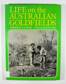
Book - Hardcover book, Life on the Australian Goldfields, 1984
A history of gold mining in AustraliaHardcover. Front cover has a photograph of two miners from West Australia using the dry-blowing technique. In the background are two 'Wood's dry placer-miners'. Back cover has a photograph of the interior of a steam-operated quartz crushing battery at the Mount Boppy Mine.Front cover has a price sticker that is discolored. Inside there is the stamp of the Marysville & District Historical Society / P.O. Box 22 / Marysville 3779 gold, gold mines, gold mining, australia, history, social life, customs, stone, derrick i, mackinnon, sue -
 Marysville & District Historical Society
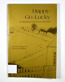
Book - Paperback book, Happy-Go-Lucky-A Gippsland Gold Town 1863-1917, 1987
A history of a gold mining town in the Gippsland area of Victoria Paperback. Gold cover. Cover has a pencil sketch of a gold mining town as well as a large gum tree on the back cover. Cover illustration runs across the whole cover.Stamp of the Marysville & District Historical Society Inc / P.O. Box 22 / Marysville 3779. Sticker - DISTRIBUTED BY: / Paoletti's (Adventurer) Maps P/L / 15 Nirvana Close, / Langwarrin. 3910 / Tel: 03 9789 6985 / Fax: 03 9776 6798 / Email: [email protected] / Other products & information Website: http://users.netlink.com.au/~maptrapgold, gold mining, gold town, gippsland, victoria, australia, history, gold miner, morgan, dorothy, morgan, marjorie -
 Marysville & District Historical Society
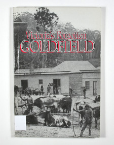
Book - Paperback book, Victoria's Forgotten Goldfield-A History of the Dargo, Crooked River Goldfield, 1996
A history of the Dargo, Crooked River goldfieldPaperback. Cover has a black and white photograph of a couple of buildings surrounded by forest. Photograph is probably of Dargo. One building has a sign that says S. Frankenberg. Another has a sign of which only the letters PION visible. In the photograph there are a number of men standing around the buildings as well as what appears to be two children sitting on a bench outside a building. There is also a large wagon-like vehicle to which is attached are a large train of oxen. In the foreground of the photograph is another group of oxen which appear to be chained together. There is also two men standing near the second group of oxen, both appear to be holding whips.The stamp of the Marysville & District Historical Society Inc / P.O. Box 22 / Marysville 3779gold, gold mining, gold town, dargo, gold miner, gold field, gippsland, victoria, australia, history -
 Marysville & District Historical Society
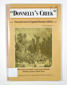
Book - Paperback book, Donnelly's Creek-From rush to ruin of a Gippsland Mountain Goldfield, 1990
A history of the Donnelly's Creek gold mine in VictoriaPaperback. Front cover has a drawing depicting two horses carrying packs followed by a man mounted on a horse. There is also two men on foot following with packs and walking poles. They are walking along a forest track that has some tree stumps alongside it.The back cover has two colour photographs. The top one is of an old wooden building with what appears to be an attached lean to. Both of the buildings have stone chimneys. There is a group of people sitting and standing outside the main building. The bottom photograph appears to be the ruins of a building and a fence. There are three people viewing the ruins.The captions accompanying the photographs are: History revisited - O'Sullivans Old Toombon Hotel Recreated and Remnants of a Bygone Mining Era.Stamp of the Marysville & District Historical Society Inc / P O Box 22 / Marysville 3779gold, gold miner, gold mining, gold field, gippsland, victoria, australia, history, fulton's creek, seaton, walhalla, aberfeldy, jericho, wood's point -
 Marysville & District Historical Society
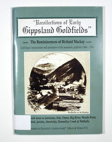
Book - Paperback book, Recollections of Early Gippsland Goldfields-The Reminiscences of Richard Mackay, 2000
Recollections by Richard Mackay of the early history of the Gippsland goldfieldsPaperback. Cover is green. Front cover has a sepia photograph of a drawing with the caption 'Walhalla in its heyday. Back cover has a photograph of an old building with a sign on it that says 'Copper Mine Hotel'. There is a man standing in front of the building. In the foreground is a four wheel drive vehicle.Stamp of the Marysville & District Historical Society Inc / P.O. Box 22 / Marysville 3779gold, gold fields, gold miner, gold mining, gold town, gippsland, victoria, australia, history, jamieson, sale, omeo, big river, wood's point, matlock, jericho, aberfeldy, donnelly's creek, walhalla -
 Marysville & District Historical Society
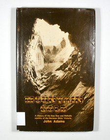
Book - Hardback book, Mountain Gold-A History of the Baw Baw and Walhalla country of the Narracan Shire, Victoria, 1980
A history of the Baw Baw and Walhalla country of the Narracan Shire, VictoriaHardback. Brown dust cover. Photograph on front cover looks out from the entry of a mine onto the front of a building which has a hill to the side of it. The back cover has a photograph of the side of a hill with some trees on it.G&V THOMAS Stamp of the Marysville & District Historical Society Inc / P.O. Box 22 / Marysville 3779gold, gold field, gold miner, gold mining, gold town, walhalla, baw baw, gippsland, victoria, australia, history -
 Marysville & District Historical Society
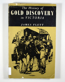
Book - Paperback book, The History of Gold Discovery in Victoria, 1979
A history of gold discovery in VictoriaPaperback. Gold front cover. Front cover has a drawing of a group of miners outside a shop. Back cover has a drawing of a group of mounted police riding roughshod through a group of people and dogs.Stamp of the Marysville & District Historical Society Inc / P.O. Box 22 / Marysville 3779gold, gold field, gold miner, gold mining, gold town, victoria, australia, history -
 Marysville & District Historical Society
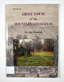
Book - Paperback book, Ghost Towns of the Mountain Goldfields, 1999
Ghost towns of the mountain goldfields in VictoriaPaperback. Cover has a drawing depicting horses, both ridden and pack, walking along a forest track on their way to a small town. There are heavily forested mountains in the distance. Overlaid onto the drawing is a modern photograph of an old stone building. In the foreground is a green timber building with a water tank and verandah. It is all set in the clearing in the middle of a forest.Stamp of the Marysville & District Historical Society Inc / P.O. Box 22 / Marysville 3779 Also the inscription: To Alma / Thanks for your help / Signature / LS / November 1999gold, gold mining, gold town, ghost town, victoria, australia, history -
 Marysville & District Historical Society
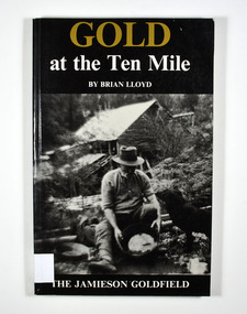
Book, Gold at the Ten Mile-The Jamieson Goldfield, 1995
A history of the Jamieson gold fieldPaperback. Black cover. Front cover has a photograph of a man gold panning with his dog in a river. In the background is an old wooden house.To the memory of my great grandfather Tom Allen,/ my grandfather Jim, Wray, my father Ben Lloyd and/ his uncle, Charlie Lloyd - all seekers of gold at the/ Ten Mile. Stamp of the Marysville & District Historical Society Inc / P.O. Box 22 / Marysville 3779 Stamp of the Marysville & District / Historical Society Inc.gold mines, gold mining, victoria, jamieson district, australia, history -
 Marysville & District Historical Society
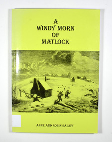
Book, A Windy Morn of Matlock, 1998
A history of the town of Matlock, VictoriaPaperback. Green cover. Front cover has a drawing depicting two men with packs and walking poles walking through knee deep snow past a wooden hut. In the background are several tree stumps and a small town of wooden buildings.For/ James and Lucienne/ Bailey Stamp of the Marysville & District Historical Society Inc / P.O. Box 22 / Marysville 3779gold mining, gold mine, matlock, victoria, australia, history, anne bailey, robin bailey -
 Marysville & District Historical Society
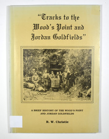
Book, Tracks to the Wood's Point and Jordan Goldfields-A brief history of the Wood's Point and Jordan Goldfields
A history of the Wood's Point and Jordan gold fieldsPaperback. Beige cover. Front cover has a black and white photograph of miners standing and sitting around a mine cart that is sitting on railway tracks at the entrance to a mine.Back cover has a cartoon drawing of a pack horse that has fallen down a cliff with his rider trying to pull him back up by his tail. Inside the cover is a drawn map entitled 'Map of the Mining District round Wood's point'.Stamp of the Marysville & District Historical Society Inc / P.O. Box 22 / Marysville 3779 gold, gold field, gold mining, gold town, wood's point, jordan goldfields, victoria, australia, history, r w christie -
 Marysville & District Historical Society
Book, Tracks to the Wood's Point and Jordan Goldfields-A brief history of the Wood's Point and Jordan Goldfields
A history of the Wood's Point and Jordan gold fieldsPaperback. Beige cover. Front cover has a black and white photograph of miners standing and sitting around a mine cart that is sitting on railway tracks at the entrance to a mine.Back cover has a cartoon drawing of a pack horse that has fallen down a cliff with his rider trying to pull him back up by his tail. Inside the cover is a drawn map entitled 'Map of the Mining District round Wood's point'.Stamp of Marysville & District / Historical Society Inc / P.O. Box 22 / Marysville 3779 gold, gold field, gold mining, gold town, wood's point, jordan goldfields, victoria, australia, history, r w christie -
 Marysville & District Historical Society
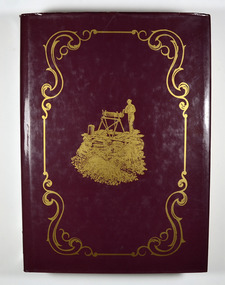
Book, The Goldfields and Mineral Districts of Victoria, 1980
A history of the goldfields and mineral districts of VictoriaHardcover. Front cover has an illustration of a miner standing next to a hole in the ground which is surrounded by logs. He is standing on top of a platform made out of planks of wood and he is turning a handle on a hand winch to bring up a bucket.Stamp of the Marysville & District Historical Society Inc / P.O. Box 22 / Marysville 3779gold mining, gold mine, mineral resources, victoria, australia, history, robert brough smyth -
 Federation University Historical Collection
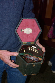
Photograph, Clare Gervasoni, Boxed Accordion by Richard H. Sutton, 2011
... . The photographs are taken in the Ballarat Mining Exchange. Boxed Accordion ...Richard Sutton established Sutton's Music Store in Ballarat.Photographs of an accordion made by Richard Sutton, father of inventor Henry Sutton. The photographs are taken in the Ballarat Mining Exchange.richard sutton, r.h. sutton, sutton's music store, accordian -
 Federation University Historical Collection
Ephemera, Various papers relating to Richard Squire Mines
In 1905 Richard Squire was manager of the West Berry Consols at Allendale, and developed an improved system of mine ventilation, which was supported in "The Age."[4] He was successful in combating and remedying the gas and ventilation troubles of the Deep Mines of Creswick and Allendale Districts after all had failed. MINE MANAGERS’ ASSOCIATION. Ballarat Branch. ... Mr R. B. Squire, manager of the West Berry Consols, at Allendale, submitted a paper detailing what he had done tor the betterment of ventilation in the alluvial mines of Smeaton and Mary borough districts- Members gave Mr Squire every credit for the results that he claimed to have effected; the adoption of his ideas had testified to their value to mine-owners. It was painted out, however, that for want of a thorough debate of the subject with experienced men the author had unwittingly included some general statements that required modifying in some points and extending in others, in justice to other workers among the earlier and the present day managers of mines. It was decided to invite the author to meet a sub-committee on this subject!Various papers relating to Richard Squire Mines including telegrams, reports, receipts, letters and newspaper clippings. .1 Souvenir Telegram .2 Telegram .3 Telegram .4 Telegram .5 Telegram .6 Telegram .7 Telegram .8 Telegram .9 Telegram .10 Telegram .11 Telegram .12 Telegram .13 Telegram .14 Telegram .15 Telegram .16 Newspaper article Mt Mercer Lease 8109, Ballarat .17 Report on the Southern Extension of Main Ballarat Goldfield .18 Letter from Harwood & Pincott Solicitors and Notaries re: Agreement .19 Ballarat Deep Leads Extensions .20 Leigh River Tunnel Syndicate Voucher x 4 .21 Debt Collector Letter .22 HY. W. Pearson Account .23 William Barrett Mining and General Blacksmith Quote and Account .24 Letter from Department of Mines, Melbourne dated 5th December 1934 .25 Letter from Mines Department, Melbourne dated 27th August 1937 .26 Documentsrelating to the purcghase of a wreath for R. Woolley .27 Prospectus of the Southern Leads .28 Propsal prospectus of Leigh River .29 Letter to Tom Squire from his brother Jim .30 Letter to Mr Squire from C Hayes regarding wages owed .31 3 copies of report on mine 8th August 1935 .32 Letter regarding unpaid account .33 Contributary causes of Collapse at Mt Mercer .34 Letter from D. Crawford re payment for timber .35 Letter from John McLeod apologising for not sending cheque .36 Letter from Department of Mines regarding Neil Cameron purchases of portions 64, 65. 66 and 71 .37 3 Letters from Department of Mines granting an extension of time to pay overdue rent. .38 Letter from Department of Mines regarding Mining Lease No. 8217 .39 Letter from Department of Mines regarding Lease Rents .40 Letter from the Department of Mines regarding further boring at Mt Mercer .41 Letter from E.R Hodge requesting that Richard Squire meet with Board members of Glenfine South .42 Letter from G Brown regarding Leases not being paid for .43 Letter from daughter Judy .44 Newspaper article regarding Berry United Deep Leads .45 Envelope addressed to R.T Squire Box 2 Tresco .46 Letter to Richard Squire from A.L. Read Date stamps richard squire, tom squire, jim squire, reports, contributary causes, account, c. hayes, proposal, prospectus, leigh river, southern leads, una cooperative society ltd., wreath, r. woolley, department of mines, e. woodlock, a.l. read, geo brown, hy. w. pearson, william barrett, ballarat deep lead extension, harwood & pincott, edmund woodlock, leigh river tunnel syndicate, federal debt collecting coy, the southern extension of main ballarat gold fields, telegram, received telegram, mt mercer lease, souvenir telegram, mining -
 Federation University Historical Collection
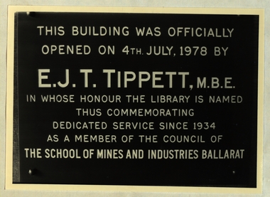
Photograph, Ballarat School of Mines Library Plaques, c1970s and 1980s
The Ballarat School of Mines is a predecessor organisation of Federation University Australia.Black and white photographThis building was officially opened on 4th July, 1978 by E.J.T. Tippett, M.B.E. in whose honour the library was named thus commemorating dedicated service since 1934 as a member of the Council of the School of Mines and Industries Ballarat Stamp Battery The stamp battery for treating gold ores was first intriduced in California. A heavy iron stamp is raised on a cam and let fall so that its weight causes the quartz which is held in the mortar box. This three head battery was installed in the mining laboratory of The School of Mines, Ballarat in 1898 and crused many hundreds of tons of quartz. It was reected on this site to commeorate the centenary of the School of Mines in 1870. School of Mines & Industries Ballarat Established - 1870 Stage one of The Vocational Skills Centre was officially opened by The Hon. Robert Fordham M.P. Minister of Education on 29th April 1983 P.R. Shiells K.J. Flecknoe Principal President The School of Mines and Industries Ballarat Established - 1870 This plaque commemorates the opening of the Hairdressing School on 9 March 1983 by Peter Cutter, B. Comms, M. Ed. General Manager - Programs, TAFE Board School of Mines and Industries Ballarat Ltd Land Laboratory officially opened by Dr D.F. Smith Director of Agriculture on 12th November 1980. School of Mines & Industries Ballarat Amenities Building was officially opened by His excellency The Hon. Sir Henry Winneke K.C.M.G., K.C.V.O., O.B.E.. K. St. J., O.C., Governor of Victoria on 7th October 1981 G.H. Beanland K.J. Beanland Principal President This room is known as the Yates Geological Centre in recognition of a professional lifetime of service from 1920=1962 as' head of Geology in The SChool of Mines and Industries Ballarat by Harold Yates M.Sc Plaque presented by former students This stone was laid by The Hon. Alexr J. Peacock Minister of Public Instruction April 14th 1899 Abdrew Anderson, Presidentbuildings, ballarat school of mines, smb campus, premier of victoria, plaque, e.j.t. tippett library, tippett learning research centre, smb library, ballarat school of mines library, e.j. tippett, smb foundation stone, smb stamp battery plaque, geology centre - yates, yates geological centre, smb amenities building opening, smb land laborarory opening, smb hairdressing school opening, smb vocational centre (stage 1) opening, smb e.j. tippett library opening, former ballarat gaol national trust plaque, former ballarat supreme court national trust plaque, smb buildings - administration national trust plaque, foundation of technical education in australia, ballarat school of mines foundation stone, yates geology centre, amenities building, land laboratory, former ballarat gaol, former ballarat supreme court, courthouse theatre, stamp battery, stamper battery, centenary, anniversary, mortar box, peter shiells, ken flecknoe, vocatonal skills centre, haidressing school, peter cutter, museum building, former wesley church, henry winneke, graham beanland, harold yates, alexander peacock, andrew anderson, a building, administration building -
Glenelg Shire Council Cultural Collection
Functional object - Scales - gold weighing, c. 1854
Betty Vivian's maternal grandfather was a gold miner at Majorca, near Maryborough Vic and the scales belonged to himBrass scales for gold, in wooden box, with brass weights and gold ready-reckoner bookletgold mining, scales, gold rush -
 Halls Gap & Grampians Historical Society
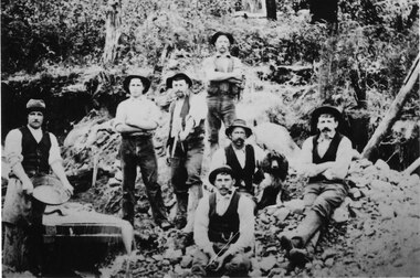
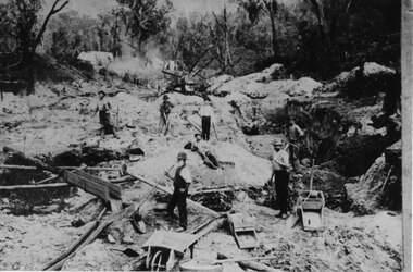
Photograph - B/W, C 1900
7 men and dog with pan and sluice boxpeople, mafeking, mining, mafeking -
 Halls Gap & Grampians Historical Society
Photograph - Sepia, C 1900
Horton's Reward Claim. This group of miners also worked another area called 'The Heather Bell" approx. 200 yards further up the gully. About half a pennyweight to the dish is obtained from the wash near the creek. They are panning off 3 dwts per day off one man's ground. This claim is about the best fitted up on the field. It is worked with a sluice box with iron ripples and feeder to match. The latter is a great advantage as there is a great fall below the claim for the tailings.Photo shows seven men working a goldfield using shovels and picks.mining, mount william, people -
 Eltham District Historical Society Inc
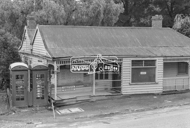
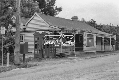
Photograph, Warrandyte Post Office, c.1972, 1972
The weatherboard building was built in the 1870s. It operated as a post office from 1876-1972. In 1988, the Warrandyte Historical Society took over the building and created a museum - https://whsoc.org.au/who-we-are/Of regional significance as an early building demonstrating the typical characteristics of early timber structures, and for its historical importance as the only relatively intact building in the town's main street dating from the gold mining period. It is also of local social significance for its important and continuing associations with the social and economic life of the town for over 100 years. - Victorian Heritage DatabaseDigital TIFF file Scan of 9 x 12.5 cm black and white printwarrandyte post office, telephone box, weatherboard house -
 Eltham District Historical Society Inc
Photograph, Warrandyte Post Office, c.1972, 1972
The weatherboard building was built in the 1870s. It operated as a post office from 1876-1972. In 1988, the Warrandyte Historical Society took over the building and created a museum - https://whsoc.org.au/who-we-are/Of regional significance as an early building demonstrating the typical characteristics of early timber structures, and for its historical importance as the only relatively intact building in the town's main street dating from the gold mining period. It is also of local social significance for its important and continuing associations with the social and economic life of the town for over 100 years.- Victorian Heritage DatabaseDigital TIFF file Scan of 9 x 12.5 cm black and white printwarrandyte post office, telephone box, post office -
 Federation University Historical Collection
Book, Hydraulic and Placer Mining, 1898, 1905
Blue/black hard covered book of 234 pages including index and photographic reproductions. Contents include Uses of Water in Mining; Geology of Placer Deposits; Gold Recovery; Flumes, ditches, dams, pipes; Giants, valaves, gates, weirs, miner's inch, pressure box, dams; gravel elvators; exploiting. mining, hydraulics, water, dredge, dredging, gold mining -
 Federation University Historical Collection
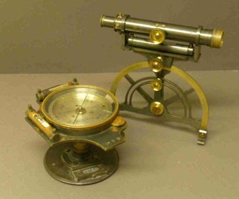
Instrument - Miner's Dial, c early 1900s
A miner's dial was used by surveyors to determine the direction of underground tunnels and roadways. The inclinometer allowed measurement of the angles at which mine tunnels descend into the ground.A rare miner's dial in a hinged timber box.This surveying instrument consists of a theodolite monsblr on a magnetic compass, which sits on the vertical tapered spigot of a base plate. Fits tripod catalogued item 4133. Inside the box lid is the supplier's label - W. Travill (successor to D. Esdale) of 146 Little Collins Street, Melbournemining, ballarat school of mines, surverying, scientific instruments, scientific objects -
 Federation University Historical Collection
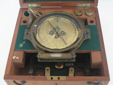
Instrument - Scientific Instrument, Miner's Dial, mid 1800s
A quadrant mounted telescope with crosshairs and external focussing, with longitudinal bubble level. Mountable on a magnetic compass plate with two bubble levels. Complete with dapered-spigot base plate and slot view attachments, Housed in a polished timber box. Inside the box are two labels -A label on the inside of the box " to the School of Mines and Industries, Ballarat" To (...) Hoadley, Esq, Principal, Footscray Technical school, Footscray WII" "Sluggish Needle, 9/4/3..." "still sluggisg 1966"mining, ballarat school of mines, surveying, archibald hoadley, scientific equipment, circumferential, scientific instruments -
 Federation University Historical Collection
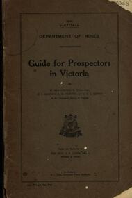
Book, Guide for Prospectors in Victoria, 1931, 1931
The handbook was intended for those with little experience who wanted to prospect of fossick.Grey soft covered book of 90 pages. Includes fold out map of a portion of Victoria showing auriferous areas and mineral localities. Also show Counties of Victoria and localities of minerals such as tin, antimony, copper, silver lead, Malybdenite, tungsten ores, manganese, platinum, osmiridium and iron. Chapter heading s include: working alluvial deposits, equipment, geology of Victoria, gold deposits, quartz reefs, indicators, economic minerals, assistance to prospectors, Miners' Right, mining bye-law, mining leases, forest regulations and glossary. Descriptions are given of a god dish, puddling tub, cradle, puddling machine, ground sluicing, boring, windlass, whim, hand dollying, sweeping, California pump, and wing dam.mining, baragwanath, gold, prospector, geology, quartz reefs, alluvial deposits, indicators, victorian goldfields, miners rights, mining leases, forest regulations, sluicing, sluice box, puddling machine, miner's cradle, whim, whip, california pump, gold nuggets, saddle reef, ballarat indicators, state batteries -
Federation University Historical Collection
Booklet, Instruments and Adjustments, 1865
Black covered exercise books with hand written by William Baragwanath. The handwritten notes are a copy of manuscript notes by A. Lilley Esquire and lent to Wiliam Baragwanath by J. Walker Esquire Ballarat and copied out in Septemeber 1895. Headings include: Instruments Chromatic Aberration Spherical Aberration Chromatic Spherical Aberration Notes by Professor Kernot on the Adjustment of the theodolite Sydney notes on Adjustment of Transit Theodolite Collimatino in Altitude Levelling To adjust a box sextant The Chain (Steel tape Projections of the Sphere W. Baragwanath Walhalla 1895mining, ore dressing, william baragwanath, alfred mica smith, instruments, theodolite, chain, surveyors chain, kernot, a. lilley