Showing 458 items
matching mining records
-
 Bendigo Historical Society Inc.
Book - MCCOLL, RANKIN AND STANISTREET COLLECTION: MISCELLANEOUS RECORDS BENDIGO MINING COMPANIES, 1930/40
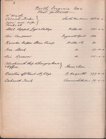
... RECORDS BENDIGO MINING COMPANIES... ORGANISATION Industry mines & mining MCCOLL RANKIN STANISTREET MCCOLL ...Book; hard cover (blue) containing paper pages with miscellaneous items of interest to McColl Rankin 7 Stanistreet. Eg. Plant purchases prospective share applicants etc.MCCOLL RANKIN STANISTREETorganisation, industry, mines & mining, mccoll rankin stanistreet -
 Bendigo Historical Society Inc.
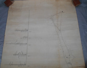
Administrative record - South Frederick The Great Mine, Sebastian, Mine map
... of the Margaret Roberts Collection of mining records.... of the Margaret Roberts Collection of mining records. Administrative ...Draftsman's drawing of South Frederick The Great Mine, Sebastian. Transverse and longitudinal Plan Forms part of the Margaret Roberts Collection of mining records.bendigo, margaret roberts, gold, map, south frederick the great mine -
 Bendigo Historical Society Inc.
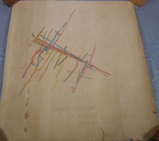
Administrative record - Lansell's Concord Mine Map
... Collection of mining records.... of mining records. Administrative record Lansell's Concord Mine Map ...Draftsman's drawing Lansells Concord Mine Map. Additional pencil markings for legend Forms part of the Margaret Roberts Collection of mining records.bendigo, margaret roberts, gold, map, mine, lansell's concord -
 Bendigo Historical Society Inc.
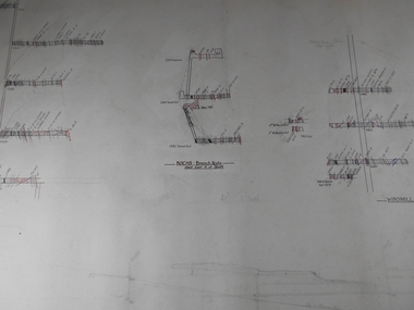
Administrative record - Confidence Cornish Kocks & Windmill Hill
... Roberts Collection of mining records.... of the Margaret Roberts Collection of mining records. Administrative ...Draftsman's drawing Confidence Cornish Kocks & Windmill Hill Long and Transverse Sections Forms part of the Margaret Roberts Collection of mining records.bendigo, margaret roberts, gold, map, mine, confidence cornish kocks & windmill hill -
 Bendigo Historical Society Inc.
Document - THE HERCULES MINE - NOTES ON THE THE HERCULES MINE
... Historical Mining Records... Goldfields Historical Mining Records Typed and handwritten notes ...Typed and handwritten notes on the The Hercules Mine at Long Gully. Notes mention locality, when it closed, date of plant auction, depth of shaft, plant, early history, where best gold was obtained, total gold yield, dividends and calls.document, gold, the hercules mine, the hercules mine, notes on the the hercules mine, long gully post office, a roberts & sons, babcock & wilcock, wheal-owl shaft, hercules and energetic, bendigo amalgamated goldfields, historical mining records -
 Bendigo Historical Society Inc.
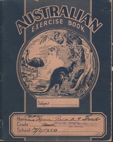
Document - MCCOLL, RANKIN AND STANISTREET COLLECTION: CENTRAL NELL GWYNNE, 17/2/1950
... Central Nell Gwynne gold mining records of stock McColl, Rankin ...Document. Exercise book - blue lined pages Battery & Mine. Records of Stock of Central Nell Gwynne Gold Mining Company. Dated 17/2/1950.McColl, Rankin & Stanistreetorganization, business, central nell gwynne, mccoll, rankin & stanistreet, central nell gwynne, gold mining, records of stock -
 Bendigo Historical Society Inc.
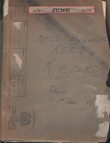
Document - MCCOLL, RANKIN AND STANISTREET COLLECTION: NELL GWYNNE REEF N/L - RECORDS, 1957 - 1974
... Nell Gwynne Reef N/L gold mining records McColl, Rankin ...Document. Well worn folder containing records of share certificates. Correspondence requesting share amou;nts and values of deceased shareholders.McColl, Rankin & Stanistreetorganization, business, nell gwynne reef mine, mccoll, rankin & stanistreet, nell gwynne reef n/l, gold mining, records -
Clunes Museum
Financial record - LEDGER
... MINING RECORDS... IN LAURA HUDSON HOUSE, FRASER STREET, CLUNES. MINING RECORDS ...FOUND IN LAURA HUDSON HOUSE, FRASER STREET, CLUNES.1 X LEDGER ENTERED BY JAMES GAMBLE IN 1877 - THE ACCIDENT RELIEF FUND NOVEMBER 17TH.YANKEE TUNNEL TRIBUTE CO. 1877mining records, benevolent fund -
 Bendigo Historical Society Inc.
Document - VICTORIA HILL - THE RICH VICTORIA HILL AND ITS HISTORICAL ASSOCIATIONS
... Mining Records and Australian Mining Standard Special... of Bendigo Obituary Notices 1904 Mining Records and Australian Mining ...Copy and a photocopy of notes titled 'The rich Victoria Hill and its Historical Associations. The photocopy does not have copies of the photos. Notes include Introduction, directions for getting to Victoria Hill, North Old Chum Mine 2310 ft deep, Ballerstedt's First Open Cut, Geographical Features, Lansell's Big 180, Crushing Battery, Lansell's Cleopatra Needle type chimney, Victoria Quartz Mine 4613 ft deep, Victoria Reef Quartz Company, Victoria Quartz Company, Victoria Quartz Dams, Rae's Open Cut, Quartz Roasting, Floyd's small 5 Head Crushing Battery, Great Central Victoria (Midway) Shaft, Ballerstedt's Small 24 yard Claim, The Humboldt, The Adventure, The Advance and Luffsman and Sterry's Claim. Copies of photos include: Victoria Hill from Rae's Open Cut, Looking North from Old Chum Hill to the Victoria Hill, the Victoria Quartz Mine and Wm. Rae's Crushing Works.document, gold, victoria hill, the rich victoria hill and its historical associations, j n macartney, quartz miners' arms hotel, ironbark methodist church, john brown knitwear factory, little 180, george lansell, conrad heinz, british and american hotel, victoria reef gold mining company, manchester arms hotel, housing commission homes, the ironbark, hercules and energetic, midway, wittscheibe, great central victoria, wm rae, mr & mrs conroy, moorhead's shop, central nell gwynne, gold mines hotel, david chaplin sterry, new chum & victoria, old chum, burrowes & sterry, rotary club of bendigo south, big 180, north old chum mine, ballerstedt's first open-cut, lansell's bit 180 shaft, victoria quartz mine, victoria reef quartz company, a roberts & sons, mr e j dunn, h harkness & sons, new chum drainage scheme, eureka extended, new chum railway, the pearl, inrush of water, shamrock, shenandoah, victoria quartz dams, rae's open cut, floyd's small 5 head crushing battery, great central victoria (midway) shaft, midway no 2, midway north, the humboldt, the adventure, the advance, luffsman & sterry's claim, chinese joss house, fortuna, p m g repeater station, bendigo and vicinity 1895, j n macartney 1st edition 1871, mr rae anderson, 'gill family, annals of bendigo obituary notices 1904, mining records and australian mining standard special edition 1/6/1899, bendigo advertiser 22/6/1871, b m l records mines department, patterson's goldfields of victoria, dickers mining record 23/11/1861, annals of bendigo, bendigo advertiser 24/7/1933, 27/8/1908, 30/6/1910, 16/6/1910, 17/6/1910, mining reports for 1910, australian mining standard special edition 1/6/1899 p40, bendigo mines ltd, mines department records, the bendigo goldfield 1851 to 1954, the victoria hill 1854 to 1949, wm rae's crushing works -
 Bendigo Historical Society Inc.
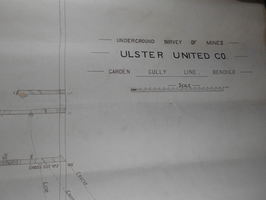
Administrative record - Ulster United Co
... of the Margaret Roberts Collection of mining records.... Roberts Collection of mining records. Administrative record Ulster ...Draftsman's drawing Underground Survey of Mines Ulster United Co. Garden Gully Line Bendigo Map. Forms part of the Margaret Roberts Collection of mining records.bendigo, margaret roberts, gold, map, mine, ulster united co -
 Bendigo Historical Society Inc.
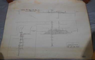
Administrative record - Central Red, White and Blue Mine map
... part of the Margaret Roberts Collection of mining records...., Surveyor Forms part of the Margaret Roberts Collection of mining ...Draftsman's drawing of Central Red, White and Blue Mine Map. Printed by Troedel & Cooper Pty Ltd. Mr. H. Cumby, Surveyor Forms part of the Margaret Roberts Collection of mining records.bendigo, margaret roberts, gold, map, mine, central red white & blue -
 Bendigo Historical Society Inc.
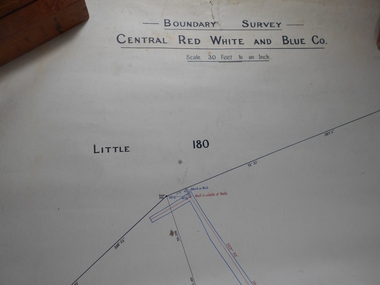
Administrative record - Central Red White and Blue Mine Map
... of mining records.... of mining records. Administrative record Central Red White and Blue ...Draftsman's drawing Boundary Survey of Central Red White and Blue Co Map. Handwritten signature of Garnet G Buich, Licensed Mining Surveyor Forms part of the Margaret Roberts Collection of mining records.bendigo, margaret roberts, gold, map, mine, central red white and blue -
 Bendigo Historical Society Inc.
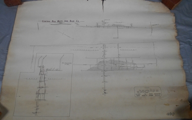
Administrative record - Central Red White and Blue Company Mine map
... of mining records.... Collection of mining records. Administrative record Central Red White ...Draftsman's drawing of Central Red, White and Blue Mine. Printed by Troedel & Cooper Pty Ltd, Surveyor Mr. H. Cumby, Bendigo April 1913 Forms part of the Margaret Roberts Collection of mining records.bendigo, margaret roberts, gold, central red white and blue gold mine, map -
 Bendigo Historical Society Inc.
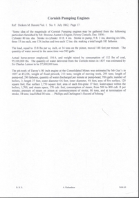
Document - MINING REPORTS - CORNISH PUMPING ENGINES
... Dickers Mining Record Vol 1 No 9 July 1862... Mining Record, vol. 1, No 9 July 1862, Page 17. Notes give... Dickers Mining Record Vol 1 No 9 July 1862 Sir Charles Lemon ...Handwritten notes on Cornish Pumping Engines, Ref. Dickers Mining Record, vol. 1, No 9 July 1862, Page 17. Notes give details of the Cornish Pumping Engines, actual horsepower, coal consumption and size of boilers.document, gold, mining reports, cornish pumping engines, dickers mining record vol 1 no 9 july 1862, sir charles lemon, consolidated mines, mr guy, phillips and darlington's record of mining -
 Bendigo Historical Society Inc.
Document - MCCOLL, RANKIN AND STANISTREET COLLECTION: CENTRAL NELL GWYNNE - FINANCIAL STATEMENTS, 24/4/36 - 21/7/44
... Central Nell Gwynne gold mining financial records F. Chenhall ...Documents. 1 folder containing financial statements of Central Nell Gwynne GMC N/L. - Loose pages containing statements, jottings and a report to the mining Co. from the mine manager (sgd) F. Chenhall. Also included is a letter dated 29/11/37 to Mr. Chenhall from Lansell Eng Works submitting a quote for some works.McColl, Rankin & Stanistreetorganization, business, central nell gwynne, mccoll, rankin & stanistreet, central nell gwynne, gold mining, financial records, f. chenhall -
 Bendigo Historical Society Inc.
Document - BIG BLUE GOLD MINE
... page, various references including Dicker's Mining Record 1862...BENDIGO Mining big blue Two page document detailing aspects ...Two page document detailing aspects of the operation of the Big Blue Gold Mine. Mining Manager William Hicks. First page details mine operation as at 16.12.1903, 1906 and 1907. Second page, various references including Dicker's Mining Record 1862. Prepared by Albert Richardson.bendigo, mining, big blue -
 Bendigo Historical Society Inc.
Document - ALBERT RICHARDSON COLLECTION: VICTORIA HILL
... Reef. (ref: Dicker's Mining Record 23rd November 1861...BENDIGO Mining victoria hill Sixteen-page document ...Sixteen-page document with details about Victoria Hill, Victoria Spurs, East Victoria Reef, Try Me Well Reef and Hercules Reef. (ref: Dicker's Mining Record 23rd November 1861) Wittschiebe & Co's Claim Victoria Hill, Victoria Reef Gold Mining Company and Victoria Quartz are mentioned.bendigo, mining, victoria hill -
 Bendigo Historical Society Inc.
Journal - Dicker's Mining Journal 1862
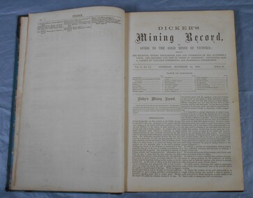
... Dicker's Mining Record and guide to the gold mines... of esteem grom J. Logan. Dicker's Mining Record and guide ...Thomas Dicker, Rowan Street, Bendigo, published a monthly mining journal that included geological information, mine details and mining practises for particular mining districts. In 1868/9, Dicker moved to England to open the "Australian and London Mining Agency" with the goals of promoting investment in Victorian mines, entering Victorian mining shares on the London Stock market, and exploring the latest in mining technology that might be suitable for mining in Victoria.Dicker's Mining Record and guide to the gold mines of Victoria, showing the bearings, depths, thickness, dips and underlies of the auriferous lodes; the progress and cost of works in operation; containing also a variety of valuable interesting and statistical information. Published by the proprietor, Thomas Dicker, Rowan Street Sandhurst. A green with black spine hardcover book. Paper glued on the front with the title Dicker's Mining Journal 1862. On the spine in gold lettering Dicker's Mining Record Vol.1 1861-2. The book contains 12 issues of the Dicker's Mining Record, the first from Saturday, November 23, 1861: the last from October 24, 1862. Also, there are two pieces of paper inside front cover with writing in pencil; the first says: shaft originally No.3 shaft of the speedwell coy. in 1902 the North Normanby Coy. was formed and took over the shaft. A new winding engine was installed in 1909. 10 head battery 1905, extra 20 head in 1909. The second, also in pencil, reads: Dept. of Mines Geological survey No.4 Ballarat East goldfields - 1907 - Mr. Marbrey (?) 39 Shamrock St. Bendigo.Sticker on inside front page: Ballarat Historical Museum presented by Mr. W.H. Lewis Young Street. On second page in pencil: Mr. John N Bailey mining manager of John Woods mines Stawell, Sons of Freedom Beaufort (illegible). To Mr. John Bailey as a mark of esteem grom J. Logan.dicker's mining journal, 1862, mining -
 Bendigo Historical Society Inc.
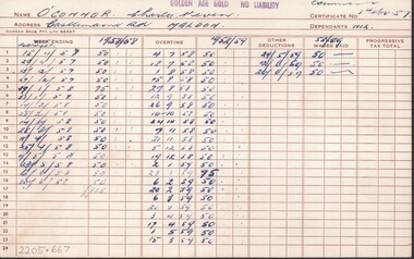
Document - MCCOLL, RANKIN AND STANISTREET COLLECTION: RED WHITE & BLUE EXTENDED MINE - ATTENDANCE & PAY RECORDS, 1957 - 1962
... Red White & Blue Extended Golden Age Gold N/L gold mining ...Document. 19 cream coloured index cards. Workers attendance & pay records. Workers holiday records.McColl, Rankin & Stanistreetorganization, business, golden age gold n/l, mccoll, rankin & stanistreet, red white & blue extended, golden age gold n/l, gold mining, attendance & pay records -
Bendigo Historical Society Inc.
Document - MINING REPORTS - EXTRACTS ON EPSOM & HUNTLY LEADS, POTTERY FLAT
... Dickers Mining Record Feb. 1862 Pages 2 & 3..., pottery Flat copied from Dickers Mining Records Feb. 1862 Pages 2... & Huntly Leads Pottery Flat Dickers Mining Record Feb. 1862 Pages 2 ...Brief handwritten extracts on the Epsom & Huntly Leads, pottery Flat copied from Dickers Mining Records Feb. 1862 Pages 2 & 3. Notes mention total number of Crushing Machines employed, three winding engines and the number employed at these 13 crushing machines - 95 men, 12 boys and 35 horses. Also the weekly crushing and the average yield per load.document, gold, mining reports, mining reports, extracts on epsom & huntly leads pottery flat, dickers mining record feb. 1862 pages 2 & 3 -
Bendigo Historical Society Inc.
Document - MINING REPORTS - FOUR SMALL (EARLY) CLAIMS ON CARLISLE UNITED GROUND
... Dickers Mining Record Feb 1862 Page 10... United Ground. Extracts from Dickers Mining Record Feb. 1862...) Claims on Carlisle United Ground Dickers Mining Record Feb 1862 ...Handwritten notes on Four Small (Early) Claims on Carlisle United Ground. Extracts from Dickers Mining Record Feb. 1862 page 10. They were Morgan, Kershner, and Co's Claim, Boyd & Co's Claim, Shanks and Co's Claim Day and Co's Claim and Brown & Co's Claim. Notes include area and title, owners, remarks, workings reef & yield and in the last one drainage.document, gold, mining reports, mining reports, four small (early) claims on carlisle united ground, dickers mining record feb 1862 page 10, morgan kershner and co's claim, james & co's claim, boyd & co's claim, boyd, abbot, pererson, taylor, watson & co, shanks and co's claim, bignal & co, day and co's claim, henry day, walter wallan, brown & co's claim, brown, grannan, day, young -
 Bendigo Historical Society Inc.
Document - ALBERT RICHARDSON COLLECTION: FATE OF MINING COMPANIES
... One page document . An extract from Dickers Mining Record... . An extract from Dickers Mining Record, Vol.1 No. 1 November 23, 1861 ...One page document . An extract from Dickers Mining Record, Vol.1 No. 1 November 23, 1861, page 2. The demise of some mining companies is discussed. Companies mentioned are McNair's Specimen Hill and the Nelson Reef with their expensive machinery and brillian prospects but who look for an early dividend. 'Those who have any knowledge at all about mining know how unreasonable such expectations are'bendigo, mining, neson reef, mcnair's specimen hill -
 Bendigo Historical Society Inc.
Administrative record - North New Moon Company N.L. MIne Manager's Report Book, 1919 - 1920
... book forms part of the Margaret Roberts Collection of Mining... forms part of the Margaret Roberts Collection of Mining records ...Dark green hard cover book, maroon binding on spine. One hundred and ninety pages of which one hundred and seventeen are used. Handwritten fortnightly entries by Alfred Bennett, Mine Manager, date from 17th January 1920 to 17th May 1924. Amount of firewood burnt in each two week period is reported. Mine Manager's book forms part of the Margaret Roberts Collection of Mining records.bendigo, margaret roberts, mine manager, paddy's gully shaft, , alfred bennett, north new moon company n.l., goldmining -
 Bendigo Historical Society Inc.
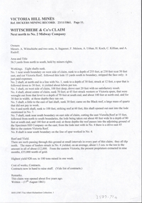
Document - VICTORIA HILL - WITTSCHIEBE & CO'S CLAIM
... Dickers Mining Record 23/11/1861... and remarks. Ref. Kickers Mining Record 23/11/1861 Page 11.... Dickers Mining Record 23/11/1861 A Wittschiebe A Sagasser F Meison ...Two copies (a & b) of handwritten notes on Victoria Hill - Wittschiebe & Co's Claim. Notes mention names of owners: Messrs. A Wittschiebe and two sons, A Sagasser, F Meison, A Urban, A Koch, C Killian and A Rudolf. Also mentioned are Area and title, workings, eight shafts were sunk, reef and yield, cost of works, contracts and remarks. Ref. Kickers Mining Record 23/11/1861 Page 11.document, gold, victoria hill, wittschiebe & co's claim, dickers mining record 23/11/1861, a wittschiebe, a sagasser, f meison, a urban, a koch, c killian, a rudolf, no 2 midway company, specimen hill company -
 Bendigo Historical Society Inc.
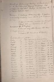
Administrative record - Great Columbian Mining Company Minute Book 1898 - 1904, 1898 - 1904
... part of the Margaret Roberts Collection of Mining records... Roberts Collection of Mining records. Preliminary meeting ...Maroon hard cover book, buff binding on spine and corners of cover. Two hundred and seventy pages. Written on first page: ' The Great Columbian Mining Company No Liability'. Minute book forms part of the Margaret Roberts Collection of Mining records. Preliminary meeting of shareholders was held at City Chambers, High Street, Bendigo on 12th September 1898; James Hedley Chairman. The Minute Book is part of the Margaret Roberts Collection of mining documents.bendigo, margaret roberts, , goldmining, mccoll and rankin, city chambers bendigo, the great columbian mining co. -
 Bendigo Historical Society Inc.
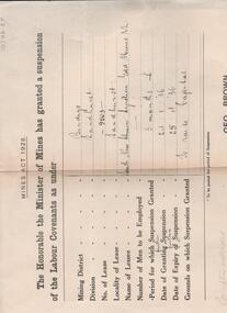
Administrative record - South New Chum Syncline Gold Mine Labour Covenants suspension, 1936
... is part of the Margaret Roberts Collection of mining records. ... of the Margaret Roberts Collection of mining records. Administrative ...South New Chum Syncline South New Chum Syncline Gold Mines, N.L., has been floated with a capital of £27,500 in 55,000 shares of 10/ each. Forty thousand have been issued at 1/,10,000 fully paid shares go to vendors, and 5000 will be held in reserve. - Messrs. Savage and Nicholas report that the issue was heavily over-subscribed. The property is situated in the central portion of the Bendigo field, adjoining such former producers as the Victoria Quartz. Lansell’s Big 180, North Old Chum and New Chum. (Bendigo Advertiser, 29th September 1932).Two documents from Department of Mines, 25th January, 1936. 'Cover letter, addressed to McColl, Rankin and Stanistreet, Commonwealth Bank Chambers, Charing Cross, Bendigo, informs 'that the Honorable the Minister has granted a suspension of the Labour Covenant of Lease No. 9903 Bendigo ...expiring on 25th April, 1936. Suspension is for the Mining District of Bendigo, division Sandhurst, No. of lease 9903 for 3 months from 24.1.36 to 25.4.36. Document is part of the Margaret Roberts Collection of mining records. bendigo, gold mining, south new chum syncline gold mine, j.j. stanistreet, legal manager, margaret roberts collection, labour convenant -
 Bendigo Historical Society Inc.
Administrative record - Catherine Reef Extended Mining Co. and Kingsley's Reward Mining Co. journal, 1919 - 1920
... of the Margaret Roberts Collection of Mining records.... of the Margaret Roberts Collection of Mining records. Administrative ...Maroon soft cover book. Inside front cover 'Journal' printed in black pencil. Six pages of financial records entries for Catherine Reef Extended Mining Co. dating from December 12th, 1905 to 17th April, 1911. One page of financial records for Kingsleys Reward Mining Co. N.L., showing unalloted shares, uncalled capital and mine account . Mine Manager's book forms part of the Margaret Roberts Collection of Mining records.bendigo, margaret roberts, legal managers, mine manager, east moon gold mining company n.l., e.g. robertson mine manager, alfred jorgensen contractor, paddy's gully shaft, derby shaft, hustler's shaft, -
 Bendigo Historical Society Inc.
Administrative record - New Chum Goldfields Company Mine Manager's Report Book, 1919 - 1920
... of the Margaret Roberts Collection of Mining records.... of the Margaret Roberts Collection of Mining records. Administrative ...Maroon hard cover book, red binding on spine, one hundred and eighty eight pages of which sixty five are used. Maroon label on front cover, 'New Chum G.F. Coy, Report Book' written on label. Mine Manager's entries date from August 11th 1919 to November 17th 1920. Two managers reported over period: : E.C. Watson and John D. Saunders. Mine Manager's book forms part of the Margaret Roberts Collection of Mining records.bendigo, margaret roberts, mccoll, sebastian, legal managers, e. watson, j. saunders, mine manager, new chum goldfields company -
 Bendigo Historical Society Inc.
Administrative record - Southern Goldfields Mining Company N.L. Share Register, 1905 - 1921
... of the Margaret Roberts Collection of mining records. ... Collection of mining records. Administrative record Southern ...Brown leather bound journal. 'Share Register' printed on spine in gold leaf. Label underneath has 'Mount Douglas Syndicate' handwritten in pen. Purple stamps on front page of journal:' Southern Goldfields Mining Company' Index of shareholder names in front of journal. Two hundred and fifty-three pages of which one hundred and fifty-three are used to record share transactions. Dates range from 1905 to 1921. Share register is part of the Margaret Roberts Collection of mining records. bendigo, margaret roberts, goldmining, mount douglas syndicate, southern goldfields mining company -
 Bendigo Historical Society Inc.
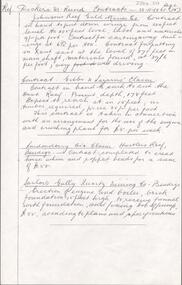
Document - ALBERT RICHARDSON COLLECTION: MINING CONTRACTS
... One page document with information from Dickers Mining... from Dickers Mining Records, Contracts 23.11.1861, page 15 ...One page document with information from Dickers Mining Records, Contracts 23.11.1861, page 15. Mine listed are Johnson Reef Gold Mines Co. To put down a winze to 305 feet level. Contract for carting away tailings, contract for putting in x cut and materials. Gibbs and Lazarus Claim, contract to sink the cut East Reef; Londonderry Co's Claim contract to erect horse and poppet heads; Sailors Gully Quartz Mining Co., erection of engine and boiler, brick foundation 15 ft high, fixing bob of pump.bendigo, mining, mining contracts