Showing 39 items
matching minister for lands
-
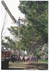
![Book - Map, Land Conservation Council, Melbourne Study Area Report, [December 1973]](/media/collectors/4f729f7b97f83e03086018a5/items/6469bc241d76dd4b008a829f/item-media/646b0013d841f8920fa4323c/item-fit-380x285.jpg) Eltham District Historical Society Inc
Eltham District Historical Society IncBook - Map, Land Conservation Council, Melbourne Study Area Report, [December 1973]
The Melbourne Study Report is a series of volumes describing the physical nature of the land and its environment, examines the likely forms of land use, and assesses the hazards associated with these uses. This is Volume 2 (coloured maps). The first page featues a black and white map described as "Shire of Diamond Valley" with public land marked in yellow. Followed by eight large fold out maps. Melbourne Study Area Public land and descriptive blocks, Population description, Geology, Physiography, topography and rainfall, vegetation and water supply. The Land Conservation Act 1970 established the Land Conservation Council whose functions is to "carry out investigations and make recommendations to the Minister with respect to the use of public land in order to provide for the balanced use of land in Victoria. This report sets out to describe and assess the natural resources of the public lands in the Melbourne area and provides a factual basis on which members of the community may base submissions to the [Land Conservation] Council of Victoria.A collection of eight large fold out coloured maps published in a bound book formnon-fictionThe Melbourne Study Report is a series of volumes describing the physical nature of the land and its environment, examines the likely forms of land use, and assesses the hazards associated with these uses. This is Volume 2 (coloured maps). The first page featues a black and white map described as "Shire of Diamond Valley" with public land marked in yellow. Followed by eight large fold out maps. Melbourne Study Area Public land and descriptive blocks, Population description, Geology, Physiography, topography and rainfall, vegetation and water supply. The Land Conservation Act 1970 established the Land Conservation Council whose functions is to "carry out investigations and make recommendations to the Minister with respect to the use of public land in order to provide for the balanced use of land in Victoria. This report sets out to describe and assess the natural resources of the public lands in the Melbourne area and provides a factual basis on which members of the community may base submissions to the [Land Conservation] Council of Victoria. maps, shire of diamond valley, population, geology, topography, rainfall, vegetation, water supply, land use, public lands -
 Marysville & District Historical Society
Article (item) - Newspaper article, The Alexandra and Eildon Standard, Indigenous history in the shire after colonisation, 08-03-2017
... lands minister... william thomas aboriginal station lands minister acheron station ...A newspaper article regarding indigenous history in the Murrindindi Shire after colonisation of the region.A newspaper article regarding indigenous history in the Murrindindi Shire after colonisation of the region.Wednesday, March 8, 2017alexandra, kulin, taungurung, goulburn, woi wurrung, yarra, acheron river, little river, dandenong ranges, land board, aboriginal guardian, william thomas, aboriginal station, lands minister, acheron station, mohican run, rubicon river, cathedral mountain, john green, mohican station, upper yarra, yarra tribe, woori yallock, hoddles creek, yarra river, badger creek, healesville, coranderrk, christmas bush, prostanthera lasianthos, black's spur -
 Bendigo Historical Society Inc.
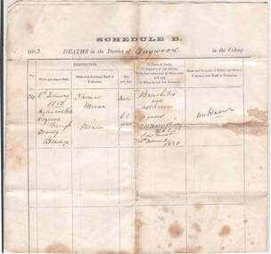
Document - DEATH CERTIFICATE OF THOMAS MORAN
Certified copy of the registration of the death and burial Thomas Moran, miner. District of Raywood, Colony of Victoria. Date of copy 19 February 1885. Signed by H.R.Hyde, Deputy Registrar, Raywood. On the rear: Noted in Lands Department, Chas A Roberts, 25/2/1885. Death of Thomas Moran - 6 February 1882 at Inglewood Hill, Raywood Borough, County of Bendigo. Male aged 61 years. Cause of death: bronchitis and asthma. Duration of last illness: 2 years. Medical attendant by whom certified: P.H. McGillivray M.R.C.S. Sandhurst. Last saw the deceased: 26 November 1881. Parents unknown. Informant: William English, son-in-law, Raywood . Deputy Registrar: H.R.Hyde. Date of registration: 7 February 1882. Buried Raywood Cemetery 7 February 1882. Undertaker: William English, Raywood. Minister/Witnesses: Dennis Fogarty, Daniel Ryan. Where born: Kilkenny Ireland, One year in NSW, 30 years in Victoria. Married Melbourne, age 34, to Mary Dundon. Issue: Mary 26 years and Catherine 25 yearsgenealogy, family, moran, thomas moran, raywood, inglewood hill, william english, h.r.hyde, p.h mcgillibray, daniel ryan, death certificate, raywood cemetery, denis fogarty, kilkenny ireland -
 Bendigo Historical Society Inc.
Document - ''THE LODDON LAND SWINDLERS'' CHAPTER FROM RESEARCH PAPER, 1992
... Mr Grant Minister of Lands... Byron Moore Mr Grant Minister of Lands Dummies Belle-Latrobe ...''The Loddon Land Swindlers'' - chapter from Research Paper, Graduate Diploma - Regional Studies (History), LaTrobe University College of Northern Victoria (Mark Ritchie, 1992). Research Paper is titled ''Masters, Mediums, Mortals and Mysia - A Regional Study of Land Settlement'' - the first chapter - 21 pages - is titled ''The Loddon Land Swindlers''. Appendix is 'poem' (''The Charge of the Dirty Three Hundred'' (not by Tennyson). Described in the accompanying note to the B.H.S by the author as ''a fascinating event in The History of Bendigo''. It relates to the Amending Land Act of 1865 (known as the 'Grant Act') and to details of the July 1865 involvement of Bendigo people - 200 men - in the Inglewood Land Selections. Reference to 'mediums' and 'dummies'. References to reports of the time in the Bendigo Advertiser.Mark Ritchieinglewood, history, land settlement, amending land act of 1965, james macpherson grant, shamrock hotel, cobb & co, inglewood advertiser, henry byron moore, mr grant minister of lands, dummies, belle-latrobe, inglewood -
 Bendigo Historical Society Inc.
Document - PETER ELLIS COLLECTION: SUBMISSION BY THE BENDIGO FIELD NATURALIST CLUB FOR THE PRESERVATION OF THE WHIPSTICK 1974, 1974
PETER ELLIS COLLECTION: SUBMISSION BY THE BENDIGO FIELD NATURALIST CLUB FOR THE PRESERVATION OF THE WHIPSTICK 1974 The submission was sent to: the Minister for Local Government and the Town and Country Planning Board The Minisry for Conservation and its agency, the Forests Commission and Lands Department Federal Government Ministeries for Environment, Concervastion and Science, and the National Estate. Opening Paragraphs: This re-submission was compiled to bring to the attention of the authorities many aspects relating to the preservation of the Bendigo Whipstick which were not so apparent at the time of the earlier submission. In fact the 19721 submissions was mainly aimed at having reserved forest (which lie a opposite extremities to the Whipstick scrub) declared Forest Park. It is the central belt of Whipstick scrub that is of scientific interest and considered unipue and which we were primarily concerned in preserving and retaining as one viable ecological unit. The Submission consists of: INTRODUCTION Opening Explanation Whipstick Eucalyptus Cutting for Oil Distallation (Photographs) Agricultural Intrusions into the Whipstick (Photographs) CONTENTS Illustrations The Significance of the Bendigo Whipstick Diary of Whipstick Conservation Events Socialogical Implications Conservation policies and reccomendations Agricultural Aspects Eucalyptus Oil Situation Alternatives for the Eucalyptus Oil Industry Future Conservation of the Whipstick Reccomendation for Acquisition Programperson, individual, peter ellis oam -
Whitehorse Historical Society Inc.
Letter - Correspondence, Mullum Mullum Creek
Letter to the Minister of Land & Works from Richard R. Cross, George Hislop, Neil Faconer (sic) and Robert Leith .Letter to the Minister of Land & Works from Richard R. Cross, George Hislop, Neil Faconer (sic) and Robert Leith regarding a track through Crown Lands which has been applied for by Messrs. Logan and Galbraith. With map.Letter to the Minister of Land & Works from Richard R. Cross, George Hislop, Neil Faconer (sic) and Robert Leith .mullum mullum creek, roads and streets, cross, richard r., hislop, george, falconer, neil, leith, robert, warrandyte mitcham track, logan, galbraith -
 Surrey Hills Historical Society Collection
Book, Historic Places Investigation, Aug-16
In March 2014, the then Minister for Environment and Climate change requested the Victorian Environmental Assessment Council (VEAC) to undertake an investigation into historic places on public land across Victoria. This final report completes VEAC's investigation.In March 2014, the then Minister for Environment and Climate change requested the Victorian Environmental Assessment Council (VEAC) to undertake an investigation into historic places on public land across Victoria. This final report completes VEAC's investigation.historiic buildings - victoria, historic sites - victoria, public lands - victoria, veac -
 Melbourne Legacy
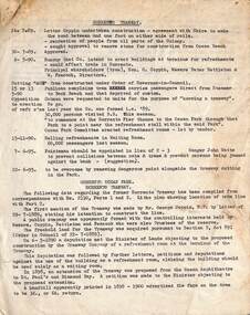
Photograph - Photo, Legacy Lone Pines, 1989
Photos of President Chas Wilks collecting pine cones from the Lone Pine descendant at the Shrine of Remembrance, the 24th Battalion tree. The cones dropped to the ground and school children are seen collecting them. Legacy has run a programme since the 1970s of propagating saplings taken from seeds of pine descended from a pine tree from Gallipoli and giving them to various clubs, schools and town councils. The photo appeared in the President's Highlights report in 1989. The caption says '1,000 seedlings from the historic Lone Pine tree near the Shrine of Remembrance will be propagated on behalf of Melbourne Legacy by the Department of Conservation Forests and Lands. Melbourne President Legatee Chas Wilks, along with the Minister for CFL, Ms Kay Setches and pupils from South Yarra Primary School helped to collect the seeds. The trees, once grown will be distributed to schools by Melbourne Legacy. Also see item at 01334 in 1993 when President Woodward was giving out saplings, it was three years later was when the saplings grown from these seeds were distributed. Legacy is helping to keep the memory of the Gallipoli "Lone Pine" alive - its spirit living on today. Presentations are made to schools, ex-service organisations and interested bodies by Legacy Clubs in the hope that they will be cherished as a symbol of nationhood and of its just pride, devotion, courage, selflessness and sense of service to others.A record of the way Legacy was propagating Lone Pine saplings for schools and organisations. The Lone Pine programme show the type of work done by Legatees to keep the memory of Gallipoli and fallen comrades alive.Colour photo x 4 of President Chas Wilks in a crane collecting pine cones at the Shrine and children collecting the cones.Handwritten '10' in a circle in blue pen.tree planting, lone pine -
 Melbourne Tram Museum
Document - report, Norm Wadeson, "Sorrento Tramway", 1961
Notes prepared by Norm Wadeson 1961 from Lands Department Records about the history of the Sorrento Tramway. Has notes on the formation, operation, passengers carried, land, possible extension, deputations to the Minister, Mr George Copin, and closure. See item 7717 for maps and photographs.Yields information about the Sorrento tramway co. and its Lands Department records.Two quarto sheets, typed - stapled in top left hand corner.tramways, tramcars, sorrento, george coppin