Showing 37 items
matching national geographic
-
 National Wool Museum
Book, Fibre and Fabric
"Fibre and Fabric: the wool, cotton, textile and allied industries in Melbourne's West" - Gary Vines, 1993. This book is a short history of the wool, cotton, textile and allied industries of the area west of Melbourne. It looks at how, why and when these industries developed and their effect upon the cultural and geographic landscape.textile industry - history woollen mills - history, textile industry - history, woollen mills - history -
 National Wool Museum
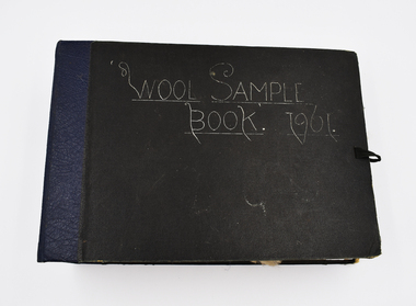
Book - Wool Sample, 1961
The donor, Brian Licence, assembled this Wool Sample Book while studying at the Gordon Institute from 1960-62. Brian studied Wool Classing and worked for a decade in this profession before moving to Melbourne which required him to change careers. The National Wool Museum accepted a donation from Brian in 2022 of several mementoes relating to his career in the wool industry. This wool sample book joins a collection of 8 others within the museum’s collection, with the oldest dating to 1870 at the time of writing in 2022. Large black bound book with ribbon for fastening containing 12 double-sided blue pages. Pages have several samples of shorn wool mounted and annotated to include information such as specific breeding, shearing faults, and geographical area. The book concludes with four pages without wool samples. Two of these pages relate to plans for a shearing shed and other industry related structures. The final two-pages relate to the anatomy of a sheep. Wool sample books were constructed by Wool Classing students at the Gordon Technical School as examples of what to look for when classing wool. The students were tasked with constructing these books with samples they retrieved themselves from several different farms and animals. The book would serve as a reference point for the wool classers throughout their years in the field, it was always on hand to refresh knowledge. This book was constructed by Brian Licence over his schooling at the Gordon between 1960 and 1962. Front Cover. Handwritten, White Ink "Wool Sample / Book. 1961”wool classing, gordon technical college, brian licence -
Koorie Heritage Trust
Book, Department of Pacific and Southeast Asian History, Australian National University, Aboriginal History - Volume 08. 1-2 1984, 1984
This volume of 'Australian History' is devoted to studies of the south-eastern corner of the Australian continent. The papers arose from a series of meetings convened with Professer R. W. Dixon in 1981. They involved scholars from the disciplines listed, all concerned with the south-east. A series of articles by leading writers on Aboriginal History.237 P.; ill,; figs.; tables; notes; reviews; 24 cm.This volume of 'Australian History' is devoted to studies of the south-eastern corner of the Australian continent. The papers arose from a series of meetings convened with Professer R. W. Dixon in 1981. They involved scholars from the disciplines listed, all concerned with the south-east. A series of articles by leading writers on Aboriginal History.aboriginal australians -- periodicals. | ethnology -- australia -- periodicals. | settlement and contacts - colonisation - 1788-1850 | race relations - violent - massacres, murders, poisonings etc. - to 1900 | sex relations | indigenous knowledge - world view | language - personal names | language - semantics | social identity | language - sociolinguistics | government policy - state and territory - new south wales | socioeconomic conditions - living conditions | language - linguistics - language classification | language - vocabulary - word lists | language - linguistics | geography - territories and boundaries | art - rock art - painting | art - production - materials / techniques | art - art motifs | -
National Wool Museum
Book, Fibre and Fabric
"Fibre and Fabric: the wool, cotton, textile and allied industries in Melbourne's West" - Gary Vines, 1993. This book is a short history of the wool, cotton, textile and allied industries of the area west of Melbourne. It looks at how, why and when these industries developed and their effect upon the cultural and geographic landscape.FIBRE AND FABRIC / Gary Vines / Melbourne's Living Museum of the West Incorportatedtextile industry - history woollen mills - history, textile industry - history, woollen mills - history -
 Parks Victoria - Wilsons Promontory Lightstation
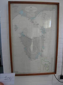
Nautical chart
Used as display in AMSA workshop foyer, Moorabbin, Vic. Nautical charts x 2 , The framed and glazed chart identifies strategic points in the notorious Bass Strait passage, which in the nineteenth century was known as the ‘Eye of the Needle’. It covers the whole of Tasmania, Bass Strait and the islands, and the lower part of Victoria with its coastline between Cape Otway and Gabo Island. The chart has an electric cord connecting it to a wall switch which enables a series of small lights to flash on strategic geographical locations.. While it is not known if it is original to Wilsons Promontory, it certainly elates to its location. A similar chart at Cape Otway shows less of Tasmania and is not electrified. Gabo Island Lightstation has two large framed charts; one is the same as the Wilsons Promontory example but without the lights and the other is entirely different, focussing on the east coast between Point Hicks and Montague Island. The Wilsons Promontory chart is unique as an illuminated version of the other charts and has first level significance if its provenance to the lightstation can be confirmed.The framed and glazed chart has an electric cord connecting it to a wall switch which enables a series of small lights to flash on strategic geographical locations.Yes -
 Bacchus Marsh & District Historical Society
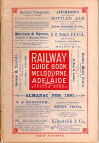
Book, Railway guide book and time table for Melbourne, Ballarat, Adelaide and all intermediate stations, also gazette for Bacchus Marsh, Ballan, Melton, &c., and almanac for 1891
Publication details: 'Railway guide book and time table for Melbourne, Ballarat, Adelaide and all intermediate stations, also gazette for Bacchus Marsh, Ballan, Melton, &c., and almanac for 1891', compiled by Christopher Crisp. Printed and published by Crisp and Lane, Bacchus Marsh, Vic., 1891. SUMMARY OF CONTENT: Includes detailed timetables and schedule of fares, descriptions of stations and refreshment facilities pp.6-26; overviews of Shires of Bacchus Marsh, Ballan and Melton, pp.27-30; historical, geographic, and economic background notes about places on the Melbourne to Adelaide route, pages 31-64, including descriptions of Bacchus Marsh, pp.34-42 and briefer notes on Ballan, pp.42-43 and Melton, pp.32-33. Almanac section is pp.65-95 (not numbered), containing common information in nineteenth century almanacs such as a calendar of the days, weeks, and months of the year; a record of various astronomical phenomena, climate information and seasonal suggestions for farmers, the rising and setting times of the Sun and Moon, dates of eclipses, hours of high and low tides, and religious festivals. A brief history of Irrigation in Mildura is on pages 1 and 112 (first and last pages). Advertisements, mostly for Bacchus Marsh businesses are on pp.96-111. The Almanac section is illustrated with drawings of scenic views of various places in Australia, but none of the Bacchus Marsh region. Online access is available on Trove at: http://nla.gov.au/nla.obj-392504046Printed book. 112 pages in total. Pages 13 -64 numbered.non-fictionPublication details: 'Railway guide book and time table for Melbourne, Ballarat, Adelaide and all intermediate stations, also gazette for Bacchus Marsh, Ballan, Melton, &c., and almanac for 1891', compiled by Christopher Crisp. Printed and published by Crisp and Lane, Bacchus Marsh, Vic., 1891. SUMMARY OF CONTENT: Includes detailed timetables and schedule of fares, descriptions of stations and refreshment facilities pp.6-26; overviews of Shires of Bacchus Marsh, Ballan and Melton, pp.27-30; historical, geographic, and economic background notes about places on the Melbourne to Adelaide route, pages 31-64, including descriptions of Bacchus Marsh, pp.34-42 and briefer notes on Ballan, pp.42-43 and Melton, pp.32-33. Almanac section is pp.65-95 (not numbered), containing common information in nineteenth century almanacs such as a calendar of the days, weeks, and months of the year; a record of various astronomical phenomena, climate information and seasonal suggestions for farmers, the rising and setting times of the Sun and Moon, dates of eclipses, hours of high and low tides, and religious festivals. A brief history of Irrigation in Mildura is on pages 1 and 112 (first and last pages). Advertisements, mostly for Bacchus Marsh businesses are on pp.96-111. The Almanac section is illustrated with drawings of scenic views of various places in Australia, but none of the Bacchus Marsh region. Online access is available on Trove at: http://nla.gov.au/nla.obj-392504046railways, railway lines, almanacs, railway lines timetables -
 Mordialloc College Alumni Association Inc (MCAA)
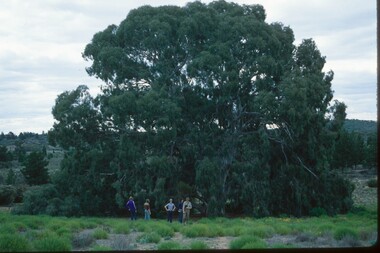
Photograph, 1979 Wyperfeld Old Be-al River Red Gum Tree, 1979
1979 - Mordialloc-Chelsea High School students standing in front of “Old Be-al” in Victoria’s Wyperfeld National Park, near Outlet Creek. It has been described as one of the most magnificent River Red Gums in the land. This glorious tree with foliage hanging to the ground escaped the fire of 1959 but not the fire of 1982 that damaged it badly. It lives on but has also suffered from lack of water and is now inaccessible to the public in a reference area. The MCAA has provided this image to the Friends of Wyperfeld National Park. Mordialloc-Chelsea High School students visited the Wyperfeld National park annually for the biology and geography Year 11 school camp.Example of a River Red Gum at Wyperfeld National Park.Digital image reproduced from colour slide.big desert fire 1959, mordialloc-chelsea high school camp, wyperfeld national park, fire 1982, old be-al river red gum