Showing 167 items matching "nepean highway"
-
 4th/19th Prince of Wales's Light Horse Regiment Unit History Room
Booklet, Lane Printing Pty Ltd, Unit Guide to the 1949 Geneva Conventions for the Protection of War Victims (Modified for Australia), 1950's
... 467 Nepean Highway, Brighton, Victoria, Australia ...A soft covered publication to acquaint all ranks with the principles of the Geneva Conventions for the protection of war victims, and to draw attention those provisions likely to concern ordinary units in the fieldDSN 7610-010-1863geneva convention -
 Kiewa Valley Historical Society
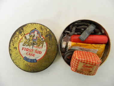
Functional object - Pocket First Aid, Circa mid 1900s
... Nepean Highway, Moorabbin, Victoria, Australia ...This pocket First Aid kit is small and compact which became available to those venturing out in the outback and required an easily managed first aid kit. It was manufactured in the mid 1900s well before vinyl and or plastic pouches or bags where used. It was in an era where valuable items were stored in durable containers due to the harsh and rugged conditions of the Australian bush. Cheaper and less durable containers from Asian manufacturers had been kept out by the heavy Tariff imposed on their goods. This changed in the 1980's when the Tariff Board was dismantled by a then Labour Government. The Australian manufacturing industry was severely reduced by the Influx of cheaper goods. This item was made by an Australian company when the motto "true blue" was the catch cry for quality Australian made goods. This was in the period where the isolation of many rural communities required the basic first aid kits to be of a tougher quality than those offered in large cities and towns.This pocket first aid kit was very compact and would have been easy to carry without taking up too much space for bush walkers, camping scouts, drovers and independent miners and cattlemen. The Kiewa Valley and surrounding rural settlements did not have the medical backup that the larger cities and towns had up until the mid 1900s when the Hydro Electricity Schemes were built and the additional influx of workers made it feasible to have a hospital and better local health facilities. This influx of the construction workers associated with the Hydro Scheme. also brought European workers who where more inclined to go bush walking and climbing the Victorian alps than the average Australian rural worker. This item is a Sanax pocket first aid round tin, gold in colour with red and white print. It's contents are: one small tube of Sanax antiseptic cream, one small one inch x six yards of gauze bandages, rubber band type ligatures with a cast iron tightener., one small tweezers three safety pins, and one lancet.On the lid there are: are outlined white cross on a blue circular background. underneath is a whiite circle encased with a red line with the following printed "Sanax pocket first aid case" (in red print underneath this is a small curved blue background and in black print "No. 26"medicine, first aid tin, camping medical supplies, personal first aid, sanax -
Glen Eira Historical Society
Document - Classic Retirement Village, Brighton
... Nepean Highway... of the Gascor site, cnr Nepean Highway and Thomas Street, to Becton... of the sale process of the Gascor site, cnr Nepean Highway and Thomas ...Four documents about the history of this site pre Classic Retirement Village: 1/A copy of a description of the sale process of the Gascor site, cnr Nepean Highway and Thomas Street, to Becton Corporation in 1997 And 1998. Printed on 31/07/2010 from the Victorian Auditor General’s Department website with aerial photograph 2/A copy of page one of the Gleneira Planning Scheme dated 19/01/2006 which mentions the Gascor site. 3/Research note by Andrew Frederick dated August 2010 listing occupiers of the site in the 1960 and the 1970 Sands and Mc Dougall Directories. 4/Research note by Claire Barton dated May 2010 containing Ian Swan’s recollections of working at Daylesford Worsted Woollen, occupier of the site, in the 1960s.thomas street, brewer road, bentleigh, gascor, becton corporation pty ltd, virginia park, gas and fuel, hughesdale dairy, east boundary road, moorabin, east bentleigh, hooblerstone, clairmont avenue, glen eira, daylesford centenary woollen and worsted mills pty ltd., nepean highway, f and j industries australia plastic and rubber division., swan ian, korman stanley, mills, wool industry, weaving mills, textile factories, textile manufacturing, manufacturing industry -
 City of Moorabbin Historical Society (Operating the Box Cottage Museum)
Document,photocopy plan 'Two Acre Village 'c1852, c1960
... seat road, nepean highway , Cheltenham inn hotel, henry dendy... along the Arthur's Seat Road ( later Nepean Highway) for sale... Road ( later Nepean Highway) for sale @ £10 It became known ...In the 1852 Josiah Holloway, a developer, purchased 625 acres from the squatters Richard and John King and sectioned '2 acre allotments' south of Henry Dendy's Brighton Survey along the Arthur's Seat Road ( later Nepean Highway) for sale @ £10 It became known as The Two Acre Village as settlers took up the allotments and established market gardens, general stores, butchers, blacksmiths, post office and 2 hotels. Charles Whorral opened The Cheltenham Inn and it became so popular as a meeting place that the area was called Cheltenham. The early settlers, who were predominantly English and Scottish immigrants initially leased their allotments and, because the sandy soil was so fertile, they were soon able to purchase the land and increase their acreage. Cheltenham became a very important part of the large Moorabbin Shire1871 and City of Moorabbin 1934 In the 1994 Amalgamation of Councils, when the large City of Moorabbin was divided between the newly formed Glen Eira, Kingston and Bayside Councils, the Cheltenham area was assigned to the City of Kingston A photocopy of the Plan for the 2 Acre Village in Moorabbin Parish c1852. A3 laminatedmoorabbin, brighton, cheltenham, market gardeners, pioneers, early settlers, , king. john, holloway josiah, whorral charles, arthur’s seat road, nepean highway , cheltenham inn hotel, henry dendy special survey 1841 -
Glen Eira City Council History and Heritage Collection
Document (Item) - Newspaper (digital), Caulfield Contact
... first stage of nepean highway widening... Alwyn Samuel, Glen Richards; First stage of Nepean Highway... Alwyn Samuel, Glen Richards; First stage of Nepean Highway ...The Caulfield Contact was the official newspaper of the City of Caulfield from 1976-1994. The City of Caulfield was the Municipal Council for an area of the South Eastern suburbs of Melbourne, including Brighton East, Carnegie, Caulfield, Elsternwick, Gardenvale, Glen Huntly, McKinnon, Murrumbeena, Ormond and St Kilda East. Following Amalgamation of City of Caulfield and parts of the City of Moorabbin in 1994, the Caulfield Contact was followed by the Glen Eira News. Includes references to the following: Children's Neighbourhood Centre Caulfield; Fire destroyed Caulfield Park Bowling Club; Naming of Harleston Park; Home Handyman Service; Profiles Councillors Peter Baitz, Ron Walters; Carnegie-Glenhuntly Football Club formed Council drops approval of rail crossings over Neerim and Glenhuntly Roads; Profiles Councillor Alwyn Samuel, Glen Richards; First stage of Nepean Highway widening; Minister approved re-subdivision; Council spills; Exciting development of Caulfield Park; Profiles Councillor Max Blair, Councillor Brian Rudzki; Tram shelter classified by National Trustcity of caulfield, caulfield, glen eira, city of glen eira, caulfield contact, children's neighbourhood centre caulfield, fire destroyed caulfield park bowling club, naming of harleston park, home handyman service, profiles councillors peter baitz, ron walters, carnegie-glenhuntly football club formed, council drops approval of rail crossings over neerim and glenhuntly roads, profiles councillor alwyn samuel, glen richards, first stage of nepean highway widening, minister approved re-subdivision, council spills, exciting development of caulfield park, profiles councillor max blair, councillor brian rudzki, tram shelter classified by national trust -
 Old School House Museum
Photograph
... Copy of an older photo, Bay St (Nepean Highway) Frankston... (Nepean Highway) Frankston Adults and children Photograph ...Copy of an older photo, Bay St (Nepean Highway) Frankston Adults and children -
 City of Kingston
Photograph - Black and white, c. 1950
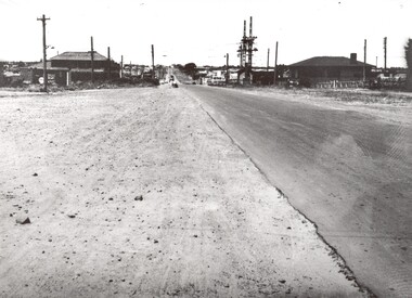
... Road, Moorabbin, viewed from Nepean Highway. ..., Moorabbin, viewed from Nepean Highway. Photograph Black and white ...This image shows a sealed road running along South Road, although with a wide gravel shoulder. The railway crossing gates were hand operated. This image is one of many in the collections that focuses on the railway. The development of the railway was crucial to the ongoing development of the area. Community life often sprang up along and beside the railway.Black and white photograph of the railway crossing at South Road, Moorabbin, viewed from Nepean Highway. Handwritten in blue ink on reverse: 217 Handwritten in red ink on reverse: 80%moorabbin, railway, railway crossing -
 City of Kingston
Photograph - Black and white, c. 1957
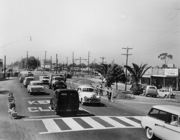
... on Nepean Highway Moorabbin before excavations for the below ground... on Nepean Highway Moorabbin before excavations for the below ground... on Nepean Highway Moorabbin before excavations for the below ground ...Copy black and white photograph of railway level crossing on Nepean Highway Moorabbin before excavations for the below ground rail crossing. The level crossing gates are closed and five cars are waiting, while other cars can be seen coming in the opposite direction. A woman with a child in a pram is walking along the road, and a number of men, probably construction workers, are standing behind a barricade on the right hand side of the road. Gilbey's Gin distillery is visible in the background. TCopy black and white photograph of railway level crossing on Nepean Highway Moorabbin before excavations for the below ground rail crossing. The level crossing gates are closed and five cars are waiting, while other cars can be seen coming in the opposite direction. A woman with a child in a pram is walking along the road, and a number of men, probably construction workers, are standing behind a barricade on the right hand side of the road. Gilbey's Gin distillery is visible in the background. Handwritten in blue ink on reverse: 57-465C Handwritten in red ink on reverse: 71% A red circle has been drawn around all handwritten text.moorabbin, railway station, railway crossing, suburbs, cars, local production -
 Robin Boyd Foundation
Slide, Robin Boyd, 1967
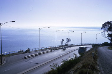
... Colour slide in a mount. View of Port Phillip Bay, Nepean... Phillip Bay, Nepean Highway, Olivers Hill, Frankston, Victoria ...Colour slide in a mount. View of Port Phillip Bay, Nepean Highway, Olivers Hill, Frankston, VictoriaMade in Australia / 20 / JUN 67M1 / Encircled 44 (Handwritten)slide, robin boyd -
Glen Eira Historical Society
Document - GARDENVALE
... Nepean Highway... gardens Nepean Highway Nepean Road North Road Kooyong Road Polo ...This file contains two items about Gardenvale, which was previously all part of Caulfield: 1/Photocopied eight page document by M. Stewart, 1961, entitled ‘The Gardenvale Story’. It describes Gardenvale Railway and surrounding roads and land. Lempriere’s Paddock, rail tracks on the main roads for the use of market gardeners’ wagons. Sale of land for O’Neill College Estate and construction of a subway through the railway embankment to Gardenvale Shopping centre, including efforts by local people and the council for work to be completed and costs. Footnote is circa 1977. 2/Map of Glen Eira printed from Council website 20/06/2014 showing Glen Eira’s share of Gardenvale.gardenvale, bent thomas, brighton, caulfield, elsternwick, railway stations, lempriere family, ‘bentville’, lempriere’s paddock, market gardens, nepean highway, nepean road, north road, kooyong road, polo, sheridan family, bluestone houses, bethlehem hospital, land subdivision, begonia street, gardenia road, gardenia street, magnolia street, lantana street, martin street, shops, ‘ben burb’, house names, padua hospital, brighton, o’neill miss, o’neill college, o’neill richard, o’neill estate, elster avenue, o’neill college estate, railway crescent, denver crescent, brentani avenue, college street, rosstown railway, brighton cemetery, ross mr, hawthorn road, ormond, gardenvale progress association, elster creek, parliamentary representatives, landscapes, gardenvale road, railway lines, subways, traders association, drainage, floods -
 City of Moorabbin Historical Society (Operating the Box Cottage Museum)
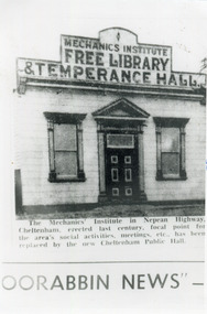
Photograph, Black & White, Cheltenham Mechanics Institute,Library, Temperance hall, c1960
... showing the Mechanics Institute, c1900 Nepean Highway Cheltenham... showing the Mechanics Institute, c1900 Nepean Highway Cheltenham ...The Mechanics Institute, built c 1890, was the focal point for the Cheltenham area's social activities, public meetings, adult education, etc. until its demolition 1960 when a new Cheltenham Hall was erectedThe early settlers erected this Mechanics Institute prior to 1900 as a public meeting place, library, temperance hall and it was used for social eventsBlack & White photograph in the Moorabbin News c 1960 showing the Mechanics Institute, c1900 Nepean Highway Cheltenhamcheltenham mechanics institute, cheltenham temperance hall, cheltenham church of christ, keys robert, lepage everet, moorabin news, leader newspapers, horse drawn carts, toll gates brighton, motor cars 1900, steam engines, early settlers, bentleigh, mckinnon, parish of moorabbin, city of moorabbin, county of bourke, moorabbin roads board, shire of moorabbin, henry dendy's special survey 1841, were j.b.; bent thomas, o'shannassy john, king richard, charman stephen, highett william, ormond francis, maynard dennis, market gardeners, vineyards, orchards -
 Chelsea & District Historical Society Inc
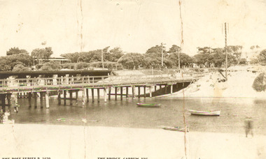
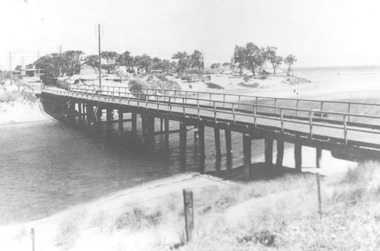
Photograph - Patterson River, Rail and Road Bridge, c 1912
... Sepia photo of the road bridge (Point Nepean / Nepean... / Nepean Highway) and rail bridge, near the mouth of the Patterson ...The first bridge over the river was built in the early 1880's, prior to this it was a pontoon bridge.Sepia photo of the road bridge (Point Nepean / Nepean Highway) and rail bridge, near the mouth of the Patterson River., Carrum patterson river, road bridge, rail bridge, chelsea, transport, patterson river bridge, carrum bridge -
 City of Moorabbin Historical Society (Operating the Box Cottage Museum)
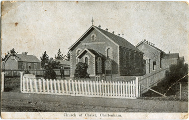
Photograph - Black & White Postcard, Cheltenham Church of Christ 40th Anniversary Invitation, c1900
... Rd and Nepean Highway Cheltenham ( ? 1900)... corner Chesterville Rd and Nepean Highway Cheltenham ( ? 1900 ...On his arrival from Scotland c 1857, James Keir commenced a communion service in his home on the Nepean Road. By 1859 the group-which included such other names as Allen, Brough, Cameron, Fairlam, Holdsworth, Le Page, Meeres, Monk, Organ, Penny, Perry, Potts, Sears and King-had built a small chapel near the corner of Wickham and Chesterville Roads. During 1858, a group had also begun meeting in the Charman family home on the corner of Charman and Balcombe Roads. Names associated with this group included Bodley, Charman, Fisher, Hayes, Hilliar, Judd, Moysey and Ruse. In 1860 they built a chapel on the corner of Charman Road and Patty Street. It was enlarged in 1866 and it became the meeting place of the two groups when they came together around 1870. They were able to buy land near the corner of Chesterville and Nepean Roads, and erected a new brick chapel on the site in 1878. This chapel, of course, continues to be an integral part of the life of the Southern Community Church and was one of the three worship venues for the 150th Anniversary celebration in 2007. The Southern Community Church was formed by the amalgamation of the Cheltenham, East Bentleigh and Hampton Street Churches of Christ in 1993, and a comprehensive new facility was designed and built to accommodate the ever-increasing activity of the amalgamated church. It was opened on 30th November 1997. ( Southern Community Church website 2019)c1878 - continuing The Church or Christ Cheltenham was one of the first places of worship established in Cheltenham by the early settlers. The settlers came together, in private homes at first, to support each other spiritually and physically and later built brick Churches for Sunday services and established social and sporting clubsBlack & White photograph as a postcard invitation to the 40th Anniversary of the Church of Christ corner Chesterville Rd and Nepean Highway Cheltenham ( ? 1900)Front Printed ; Church of Christ Cheltenham Back Printed ; POST CARD / One Penny Postage within Commonwealth / The address only to be written here/ One penny Stamp/ Sunday School Anniversary, / OCTOBER 27TH & OCTOBER 30TH / TO WHICH YOU ARE / CORDIALLY INVITED Handwritten in ink ; H.W. got the cramps in the pants. He took some pills then ran over the hills undatedearly settlers, bentleigh, mckinnon, parish of moorabbin, city of moorabbin, county of bourke, moorabbin roads board, shire of moorabbin, were j.b., o'shannassy john, king richard, charman stephen, highett william, ormond francis, maynard dennis, market gardeners, vineyards, orchards, keir james, lepage frank, lepage everest, holloway josiah, bruton henry, keys robert, judd clarence, fairlam percy, meeres william, southern community church, cheltenham, cheltenham church of christ -
 Ringwood and District Historical Society
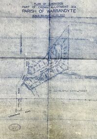
Map - Plan of Subdivision, Part of Crown Allotment 31A, Parish of Warrandyte - (Undated)
... Nepean Highway, Frankston 31736.... Nepean Highway, Frankston 31736. Facsimile blueprint copy of 24 ...Facsimile blueprint copy of 24 residential allotments with property dimensions in Bailey Crescent (later Gabriella Court) and McEwan Street (later Suzanne Court) off Park Road and Evelyn Road, Ringwood North.Rubber stamp impression - J. Horne, Licensed Surveyor, 458 Nepean Highway, Frankston 31736. -
 Chelsea & District Historical Society Inc
Photograph - Patterson River, Rail and Road Bridge, c 1910
... Nepean / Nepean Highway), over Patterson River, Carrum near... bridge (Point Nepean / Nepean Highway), over Patterson River ...The first bridge over the river was built in the early 1880's, prior to this it was a pontoon bridge.Black and white photo of the wooden road bridge (Point Nepean / Nepean Highway), over Patterson River, Carrum near the mouth of the river. patterson river, road bridge, rail bridge, chelsea, transport, patterson river bridge, carrum bridge -
Glen Eira Historical Society
Ephemera - St. Mary’s Church, Caulfield
... Nepean Highway... and Drycleaners Drycleaners Glen Huntly Road Elsternwick Nepean Highway ...Two copies from St. Mary’s Anglican Church Caulfield, orders of service to celebrate Victoria’s 150th anniversary April 28, 1985. Four copies of pamphlet from St. Mary’s Anglican Church, Caulfield for The Joys of Living in Victoria, a festival of flowers and music dated April 25-28 1985. Included is a brief history from the 1850’s to 1985 of the church. Official opening leaflet with details of events and sponsors. The Joys of Living in Victoria, a festival of flowers and music order of service. Roneoed copy dated 25/04/1985.st. mary’s anglican church, caulfield, brooks r.c. rev., glasson william, organists, glen eira road, allen s. m. and sons, furniture stores, kennington laundry and drycleaners, drycleaners, glen huntly road, elsternwick, nepean highway, gardenvale, caulfield south, t. bathursts and co., funeral directors, ricks camera shop, elsternwick furnishing co., rothels pty. ltd., the sausage factory, four corners picture framing co., taylors the discount store, eight st. georges road, reception rooms, mane event hairdressing, fiskens pharmacy, boyd w. fox chemist, elsternwick travel world, mahony denis, hairline 309, hairdressers, madge tulloch florist, florist shops, michelson and associates, estate agents, port phillips press pty. ltd., printing industry, sommers jill, caulfield city choir, choirs, the tait-smith chamber group, tudor choristers, cathedral brass ensemble, trumble joan, brookes raymond rev., porter miss, park street, stephen george sir, hood crescent, bluestone, reid mr., architects, macartney mrs., st. mary’s church, st. stephen’s, gardenvale, st. clement, elsternwick, st. agnes, glenhuntly, glen huntly, st. catherine, caulfield, langley canon, shelford, green bishop, schools, helenslea, caulfield grammar school, davis j.h. rev., house names -
Glen Eira Historical Society
Map - Orienteering
... Nepean Highway... Associations Nepean Highway Bentleigh RSL Club Orienteering Sports ...This file contains one item. A map/plan of the Bentleigh East Running Roulette for the Monday series on 21/03/2011.bayside kangaroos orienteering, bentleigh east, sedunary vic, leicester paul, sheahan jenny, clubs, sheahan john, tamblyn greg, centre road bentleigh, tucker road bentleigh, south road moorabbin, associations, nepean highway, bentleigh rsl club, orienteering, sports, recreations -
Glen Eira Historical Society
Letter - Elsternwick Congregational Church – Caulfield Union Church
... Nepean Highway... Whiteway Neon P.L. N. and D. Panagiotou Nepean Highway H.C. Sleigh ...One page of Caulfield Council’s E.S. and P. Committee agenda, item and minutes dated 14/05/1971 concerning permit application from St. John’s Uniting Church for the Victorian Music Theatre Pty Ltd to Conduct singing lessons in the church building. Typed letter dated 08/12/1987 from National Trust to St. John’s Parish noting the Trust’s classification of the church building and the accompanying citation. Typed letter dated 20/07/1988 from the historic buildings council to Caulfield Historical Society concerning the hearing to discuss inclusion of the church building on the register to be held on 24/08/1988. Copy of historic building council’s agenda item undated describing the significance of the former Union Church. Thirteen page assessment of the architectural significance of the former Union Church dated 24/08/1988 by Anne Neale. Includes sketch of the exterior and references. Handwritten notations by Jim O’Loghlin dated 24/08/1988. Photocopy of the page from the Victoria Government Gazette dated 05/10/1988 advertising the amendment of the register of historic buildings to include the former Union Church building. A twelve page document produced by the Historic Buildings Council Victoria, date unknown, which describes the council’s operations and activities.st. john’s parish of the uniting church, e.s. and p. committee, congregational church, orrong road, victorian music theatre pty ltd, king street, glen huntly road, melbourne neon ltd, balaclava road, whiteway neon p.l., n. and d. panagiotou, nepean highway, h.c. sleigh ltd., poath road, carden w. j., warren r.p., talbot avenue, new l. mrs., elsternwick, zoning, st. georges road, architectural features, caulfield union church, towers, de lacy evans george, mcmurtie mcnaughton and stewart, glen eira road, neale anne i., mcloghlin jim, architectural styles, gothic style, caulfield, caulfield historical society, gregson w. rev., st. aloysius caulfield, brick -
Glen Eira Historical Society
Article - Classic Retirement Village, Brighton
... Nepean Highway..., With Photographs, About Brighton Classic Nepean Highway Thomas Street ...Newspaper Article Dated 24/09/2009 From The Age Concerning Suburb Name Change of Bentleigh To Brighton For Brighton Classic. Newspaper Article Source And Date In 2010 Unknown, Concerning Tenth Anniversary Of Brighton Classic Residences. Brighton Classic Newsletter Dated Winter 2002 Describing The Lifestyle And Apartments For Sale Includes Photographs Undated 18 Page Brochure, With Photographs, About Brighton Classicnepean highway, thomas street, brighton classic, brighton east, bentleigh west primary school, glen eira council, bentleigh, becton corporation, loeliger sue, retirement homes and villages, aged people, flats, bentleigh woollen mills -
Glen Eira Historical Society
Plan - Nettalie
... Nepean Highway... Hotel Hotham Street Horne Street Nepean Highway North Road ...An A4 photocopy of the 'Plan of the Caulfield Road District' dated 1867. This plan shows the location of the properties owned by A Shaw and Blundell on Balaclava and Orrong Roads where Nettalie is situated. The plan includes all the landowners listed where their property was, the street names and other landmarks of 1867 including railways, hotels and reserves.caulfield, caulfield north, elsternwick, st kilda east, parish of prahran, parish of moorabbin, caulfield road district, melbourne and brighton railway, rosstown railway, elsternwick railway station, caulfield railway station, rosstown railway station, murrumbeena railway station, baptist church, paddy’s swamp reserve, cemetery reserve, leman swamp reserve, caulfield racecourse reserve, brighton cemetery, the vine caulfield hotel, the tam o’shanter hotel, melbourne hunt hotel, royal hotel, hotham street, horne street, nepean highway, north road, orrong road, dandenong road, princes highway, kooyong road, alma road, inkerman road, balaclava road, glen eira road, glen huntly road, hawthorn road, cemetery road, bambra road, redan road, kambrook road, neerim road, booran road, racecourse road, grange road, koornang road, murrumbeena road, crosbie road, kangaroo road, poath road, ford w, lempriere, cople j, riddell j c, manifold j, testar t, billing r h, semple, blundell, shaw a, butchart g, stephen j w, stephen g sir, hart j, duncan g, blackie r, stephen f, mccombie t, woollaston h, higgins j, lloyd j c, daish j, mcleod j, hughes d, wilson a, jamieson g, webb g h, renwick s, pennington h, dunn j, kirkpatrick w, ricketson w, toad a, sayce j, watts t, widgery, store, guess j, anketell j, clack j, sissen w, clayton g, dickson d, bevan j, hart t, anderson j, hart mrs, webb h, masters s, waghorn j, hemming c, hiam c, farquhar w, newing t, payne t, cooper r, snipe s, chambers j, forster w, summers r, harriman b, warrick, o’connell, long j, peck r, cochrane c, murray ross w, evans c, kennedy j, maclean n, forster, lyall w, dean j, newton h, looker w, baker c, johnston, crosbie j, kerr, jones, parr, nelson c, montgomery l, parsons w, james j c, sibon c, smith sydney w, plans, maps, land subdivisions, land use, settlements, roads and streets, hotels, churches, police stations, post offices, land surveys, railway stations, railways, schoolhouses, commerce, clergy residences, official buildings, local government, road districts -
Glen Eira Historical Society
Document - Brewer Road, 8, Bentleigh
... Nepean Highway... Nepean Highway Brick houses Furniture Furnishings Document Brewer ...A copy of a two page valuation letter, dated 18/04/1966, to McKenzie and Ross Solicitors to a valuator, regarding the estate of John H Holmes at Brewer Road, 8, Bentleigh and including a description of the land and house improvements. The file also includes two pages of handwritten working notes for the purposes of the property valuation. The file also includes a two page typed document, undated, containing an inventory and valuation of furniture and effects of the property.holmes john h, brewer road, bentleigh, thomas street, bentleigh west state school, nepean highway, brick houses, furniture, furnishings -
Glen Eira Historical Society
Map - Brady’s Stables, Elsternwick
... Nepean Highway... Nepean Highway Stables Map Brady’s Stables, Elsternwick ...Hand drawn map and plan (250mm x 200mm) of Brady’s Stables, Elsternwick, undated and unattributed. The file also includes a brief handwritten research note by Peta Darke dated 09/08/2011.brady’s stables, elsternwick, glenhuntly road, glen huntly road, brighton road, elsternwick railway station, nepean highway, stables -
 City of Moorabbin Historical Society (Operating the Box Cottage Museum)
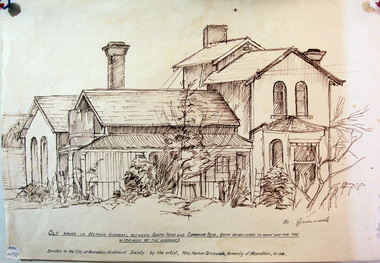
Drawing, of early house Cummins Road Moorabbin, c1950
... nepean highway... bbrighton early settlers bentleigh nepean highway arthur's seat road ...A pencil sketch of an early house on the corner of South Road and Cummins Road by Marian Grimwade. signed : M Grimwademoorabbin, bbrighton, early settlers, bentleigh, nepean highway, arthur's seat road, moorabbin district roads board, market gardeners, artists, grimwade marian, -
 City of Moorabbin Historical Society (Operating the Box Cottage Museum)
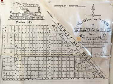
Document, photocopy of Plan of Beaumaris 1853, c1960
... road, nepean highway, morabbin district roads board... charles, arthur’s seat road, nepean highway, morabbin district ...Beaumaris includes two early estates in the parish of Moorabbin developed by Josiah Holloway from 1852. Named Beaumaris Town and Beaumaris Estate (after the pastoral run in the area and ultimately after Beaumaris in Wales), the lots comprising them were marketed by Mr Holloway's suggesting that the railway was imminent and a canal would be built. The township developed slowly, a Post Office opened on 1 March 1868, but was replaced next month by Gipsy Village office (now Sandringham) In 1862 Beaumaris was one of the early settler communities within the boundaries of the Moorabbin District Roads Board , the region’s first local government authority. Beaumaris is a suburb in Melbourne, Victoria, Australia, 19 km south-east from Melbourne's central business district. .Since the Amalgamation of Councils 1994 the local government area is the City of Bayside which includes Brighton. A Photocopy of the Plan of Beaumaris 1853 A3moorabbin, county of bourke, brighton, beaumaris, pioneers, early settlers. market gardeners, cheltenham, king. john, holloway josiah, whorral charles, arthur’s seat road, nepean highway, morabbin district roads board, sandringham, mordialloc, mentone -
Glen Eira Historical Society
Article - St. Clement’s Church of England, Elsternwick
... Nepean Highway... Anglican Church Nepean Highway Article St. Clement’s Church ...This file contains two items: 1/An article from Southern Cross, dated 15/12/1993, detailing proposed eviction of ‘Little Kids Occasional Care Centre’ if Brighton Hyundai go through with plans to enlarge their parking storage area in the current Miller Street, St. Clement’s Church Hall. 2/An article from the Port Phillip Leader, dated 03/04/2012, about the increased attendances of churches, mentioning Rev. Rowan Fairbairn of St. Clement’s Anglican Church.southern cross, leigh howard, elsternwick, kindergartens, st. clement’s church of england, st. clement’s anglican church, halls, miller st., brighton rd., glenhuntly rd., hotham st., hislop john rev., richtman shana, north caulfield, pearce sue, stephens katie, grossbard alain cr., little kids contact and occasional care centre, brighton hyundai, caulfield council, thurston richard, fairbairn rowan rev., st. clement’s anglican church, nepean highway -
Glen Eira Historical Society
Book - CAULFIELD CENTENARY 1957
... Nepean Highway... Road Orrong Road Poath Road North Road Booran Road Nepean ...This file contains four items 1/Two copies of a twenty-four page booklet titled CITY OF CAULFIELD CENTENARY 1857-1957, created by the Caulfield City Council and printed by Peter Isaacson Pty Limited, Melbourne. The booklet details important aspects of Caulfield’s history including council procedures, the Caulfield Road District Proclamation, the first election and a summary of 100 years of local government with a description of the present Caulfield in 1957. The booklet also includes several pictures of various Caulfield landmarks and people including one of Caulfield City Councillors (11 men and 1 woman). Also one photocopied version of this booklet. 2/Eleven pages of typed notes for the City of Caulfield Centenary booklet. All notes are undated and incomplete. Two pages titled NOTES on THE HISTORY and PROGRESS OF THE CITY OF CAULFIELD, author unknown. Three and a half pages titled THE STRUCTURE OF LOCAL GOVERNMENT IN VICTORIA, author unknown. Five pages titled 100 YEARS OF LOCAL GOVERNMENT – EARLY CAULFIELD, by Mrs A. P. Bell. 3/A typed letter to Miss V. Webb-Langdon from the Town Clerk H.G. Nelson, acknowledging her contribution to historical details for the Caulfield Council’s Centenary booklet, dated 24/12/1957. 4/A handwritten letter and a handwritten note regarding the acquisition of notes for the Caulfield Centenary booklet. The letter is dated 03/08/2006 and the note is dated 09/02/2007.city of caulfield centenary, caulfield road district, sinclair a.j.g., city hall, war memorials, gamble h.a., machin l.r., bunny f.c.d., caulfield park, koornang reserve, parton e.m., sims h.e., thomson w.r., gunn e.e., yorston j.s., wallace g.e. mrs, green w.c., jenner e.r., ward boundaries, dandenong road, queens avenue, normanby road, station street, bond street, glen eira road, orrong road, poath road, north road, booran road, nepean highway, glen huntly road, glenhuntly road, inkerman road, hotham street, nelson h.g., fullard w.r., mackley g.j., ellis k.i, crosbie m.r., nutting b.i., body j.h., pritchard r.j., guildford l.t.g., lund l.m., street h.c., reynolds a.w., elections , political processes, local government, springthorpe reserve, greenmeadows gardens, business and finance, roads and streets, caulfield racecourse, east caulfield reserve, mackinnon reserve, hawthorn road, balaclava road, murrumbeena road, lempriere avenue, victoria street, koornang road, lord reserve, lyons street, murrumbeena reserve, kangaroo road, ormond park, beatty crescent, foch street, packer reserve, oakleigh road, leila road, prices park, bambra road, riley reserve, playgrounds, town hall, maternal and child health centres, truganini road, grange road, senior citizens centre, barkley sir henry, moore david, handasyde gilbert, caulfield school room, harris g.w., semple john, dempsey william, brooks w.a., wilson thomas, lyall william, murrum murrumbeen lifestyle, ‘greenmeadows’ house, lempriere family, aboriginal culture, ‘rippon lea’ house, caulfield john, ‘slaney’s’ home, alma road, paddy’s swamp, racecourse hotel, caulfield technical college, bevan mr., ‘grosmont’, hart john, railways, mansions, ‘rosecraddock’, langdon h. j., caulfield cup, ‘crotonhurst’, webb judge, ‘kilwinning’, service james, ricketson henry, ‘glen eira’, house names, garden vale, ross william murray, ‘ross’s folly’, outer circle railway, caulfield grammar school, davies j. henry, lagdon william, grimwade f.s., loyd charles du plan, hope george, ‘airdrie’, kooyong hill, market gardens, dairies, lady talbot milk supply, jenner family, o’niell college, presentation sisters, glenferrie road, grimwade frederick sheppard, grimwade alice, ‘harlston’, grimwade house, ‘saint aubin’s’, ‘st. aubin’s’, ‘caulfield hall’, caulfield john p.t., st georges road, caulfield military hospital, nursing homes, health establishments, dover street, sports and recreations, rosanna street, ‘cantala’, health services, parks and reserves, community services, town planning, local government finance, local officials and employees -
Glen Eira Historical Society
Photograph - Elsternwick
... Nepean Highway... Glen Eira roads Point Ormond Glenhuntly Railway Station Nepean ...This file contains three items. Photocopied and three page retyped article, undated c.1930s and source unknown from Real Estate Agent Philippe Batters 03/09/1997. Three page document from Keith James Smith, undated, on research on Elsternwick and Glen Huntly Road shops and traders. Three articles from THE AGE 13/05/2000 and 15-16/02/2013 and MELB BAYSIDE WEEKLY 03/11/2010 giving snap shots of Elsternwick housing and facts.batters philippe, real estate agents, elsternwick, paddocks, glen huntly road, walter kelly, elsternwick park, slaughter yards, glen eira roads, point ormond, glenhuntly railway station, nepean highway, grange road, holdsworth’s jewellers, staniland grove, coles store, shops, orrong road, fosseys, hattams mensware, woolworths, dalgarnos crockery and kitchenware, chapmans gifts, garth’s shoe store, garth jack, allen’s furniture and auction rooms, elsternwick market, adam’s cakes, mr. green’s pet shop, turner mr., grocer shop, moores lendring library, hopetown gardens, gardens, jack hatheralls butchershop, butchers, chinese laundry, chinese community, laundries, mr. & mrs. darbyshires milkbar, st. johns church, kooyong road, hasseles garage, garages, royal parade, glenhuntly, camden, hawthorn road, blacksmiths, camden town, dolls hospital, caulfield state school 773, independent picture, theatres, camden theatre, southern indoor bowl centre, larch street, montessorie school, collins milk bar, milk bars, collins lin, hartrick miss, armond mr., lennie mr., rothells sausage factory, north road, red bus service transport, furlonger miss, dance studio, moran and cato grocery, cato family, newsagent, tozer brook, furniture store, green gables american style soda fountain and milk bar, hoyts renown theatre, state savings bank, riddell parade, clarence street, aileen avenue, smith keith james, camden town, sports club, peer gary, gary peer & associates, brukarz jack, ray white real estate, real estate agents, classic cinema theatres, st. george’s road, elizabeth street, allison road, gladstone park, myrtle street, victoria street, caulfield, st kilda east, lisbon house, orrong road, house names, rippon lea estate, caulfield south, carnegie, gordon street, carre street, main street, clarence street, elsternwick club, jewish holocaust museum, daily planet, brothels, wesley college, elsternwick primary, st. joseph’s primary, scholem aleichen college, liebler yavneh, hopetoun gardens, harleston park -
Glen Eira Historical Society
Book - Local Government Act First Report of the Assistant Commissioner of Roads and Bridges
... Nepean Highway... Moorabbin Road Districts Point Nepean Road Nepean Highway Dandenong ...This file contains 1 item: 1/The Local Government Act, First Report of the Assistant Commissioner of Roads and Bridges, printed by order of the Victorian Legislative Assembly on 08/03/1865. The document is the first annual report of John Steavenson, Assistant Commissioner of Roads and Bridges under s330 of the Local Government Act no. 176 (1863), and relates to transactions which took place from 02/09/1863 to 31/12/1864. The report outlines operations carried out by the Department of Roads and Bridges in this period. In the Glen Eira area this includes: separating electoral subdivisions of single districts (Moorabbin), adding detached portions of territory to road districts and shires (Caulfield), appointing of and altering in polling places, appointing of polling places for ridings of shires and subdivisions of road districts (Moorabbin), preparing and transmitting of forms of books also of pro forma accounts for guidance of local bodies in keeping their accounts, appointment of main roads, construction of a main road, ‘Dandenong’, in the Caulfield and Gardiner districts, proclaiming of Common Toll Roads, names of and security given by Managers of Common Toll Roads. The report also gives some information about the Shire of Caulfield, which contained 24 road districts and 340 rate payers in 8¼ square miles, and the Shire of Moorabbin, which contained 62 road districts and 713 rate payers in 30 square miles.local government act, assistant commissioner of roads and bridges, legislative council, caulfield historical soceity, steavenson john, sullivan j. f. the honourable, caulfield, moorabbin, road districts, point nepean road, nepean highway, dandenong road, princes highway, brown edwin, osher joseph, cosgrove john, ferres john, roads and bridges offices, caulfield roads district, moorabbin roads district, road construction and maintenance, roads and streets, acts of parliament -
Glen Eira Historical Society
Document - History of the City of Caulfield
... Nepean Highway... Rosstown Poath Road Nepean Highway Hotham Street Ormond Park ...This file contains 4 items: 1/Typewritten document titled ‘The City of Caulfield’. Author and date unknown. 1 page (back and front), 2 copies. Document covers topics such as origins of the name ‘Caulfield’, early settlement and the Caulfield Cup. 2/Typewritten document titled ‘History of Caulfield Council’. Author and date unknown. 6 pages, 3 copies. Document covers subjects such as early settlement, Aboriginal influence, Caulfield Road Board, Shire of Caulfield, Borough and town boundaries, coat of arms, and Freedom of Entry to the City. 3/Typewritten document (undated + author unknown) titled ‘The Structure of Local Government in Victoria with a history of the City of Caulfield’. 13 pages. Covers the following subjects: Powers, Planning, Public Works, Trading Undertakings, Health Services, Municipalities, Wards Electors or Ratepayers, Voters Roll, Councillors, Officers, Finance, Nature of Soil and Vegetation, Parks and Gardens and Reserves, Coat of Arms, Boundaries, How Did Caulfield get its Name, Aboriginal Influence, Caulfield Road Board, Shire of Caulfield, Borough and Town and the City of Caulfield. Also covered is early settlement. Note at the end of the document mentions that the historical content contained in the last section was based upon a thesis for the Department of Town and Regional Planning, University of Melbourne, 1968 by L. Alwis, P. Rowe, N. Wootten. Melbourne, ‘City of Caulfield: An Illustrated City Report’. 4/Typewritten document (undated) titled ‘The Structure of Local Government in Victoria with notes on the history of the City of Caulfield’. 8 pages, 2 copies. This document also includes a map/diagram of the city with boundaries and wards showing locations of railway stations and parks. Document covers the structure of local government and its functions then goes on to focus on City of Caulfield with subjects similar to those covered in item 3. Document signed off by Deputy Town Clerk.city of caulfield, caulfield john, caulfield baron, caulfield racecourse, elsternwick, ripponlea, st. mary’s church, caulfield council, kooyong road, neerim road, bambra road, greenmeadows house, caulfield park, paddy’s swamp, dandenong road, caulfield grammar school, chisholm institute of technology, murrumbeena, glen eira road, alma road, orrong road, balaclava road, inkerman road, ‘grosmont’, caulfield school room, caulfield road board, caulfield road district, crimean war, victorian amateur turf club, caulfield cup, glenhuntly road, north road, glenhuntly station, ormond station, outer circle railway, local government, gardenvale, carnegie, rosstown, poath road, nepean highway, hotham street, ormond park, princes park, ross william murray, caulfield institute of technology, ‘ross’ folly’, hawthorn road, glenhuntly, ormond, morris t. w., lloyd charles du plan, meals on wheels, shire of caulfield, caulfield railway station, caulfield rsl, bouran road, murrum murrumbeen, kooyong road, great dandenong road, neerim road, trams, prahran and malvern tramways trust, fisher andrew, mackinnon reserve, dover street, ‘glen eira’, blair max cr., insignia, third ordnance services unit, schools, street lighting, lampriere, mr. bevan, the caulfield leader, davies j. henry, curraweena road, st. georges road, o’neill college, hope george, market gardens, koornang reserve, packer reserve, murrumbeena reserve, hopetoun gardens, greenmeadows gardens, mirambeena, caulfield technical college, hart john, langdon h. j., ‘rosecraddock’, judge webb, ‘crotonhurst’, service james, ‘kilwinning’, ricketson henry, grimwade frederick sheppard, airdrie, jenner, st. aubin’s, caulfield john p. t., harlston, lempriere, lord reserve, ‘cantala’ -
Glen Eira Historical Society
Document - National Trust Register
... Nepean Highway... Tucker Road McKinnon Road Nepean Highway Wheatly Road Uniting ...This file contains two items relating to historic buildings in Glen Eira listed on the National Trust Registry: 1/A fax, sent to Gladys Vallati on 02/03/1995 from the National Trust of Australia listing buildings on the Trust’s registry in the Glen Eira area, as well as their addresses and status on the register (5 pages). (Additional photocopy taken for preservation purposes). 2/A typed list of buildings in the Glen Eira area (mainly Caulfield) which are on the National Trust list, including address, approximate date of construction and status on the register. Date of production of the list is unknown. (6 pages).neerim road, poplar grove, avoca grove, balaclava road, orrong road, bambra road, glen eira road, hood crescent, hawthorn road, glenferri street, glenhuntly road, glen huntly road, kambrook road, kooyong road, lirrewa grove, manor grove, north road, pearson avenue, seymour road, alma road, craddock avenue, dandenong road, lyndoch avenue, orrong crescent, hotham street, nagle avenue, inkerman street, iknerman road, sandham street, selwyn street, st. georges road, willow street, grange road, station place, railway parade, alexandra street, wood crescent, elizabeth street, halstead street, mavho street, tucker road, mckinnon road, nepean highway, wheatly road, uniting church carnegie, athole, st stephen's uniting church caulfield, st aloysius' catholic church, halstead, st mary's anglican church caulfield, caulfield town hall, anseln, the glen, woolamai, caulfield house, caulfield hospital, lirrewa, labassa, fairfield hall, bellecourt, bagatelle, myoora, rosecraddock, adam and eve - karl duldig, the family - karl duldig, caulfield primary school, septimus miller memorial chapel, brighton cemetery, hopetoun gardens, state savings bank elsternwick, anderson organ, hopetoun private hospital (melrose), rippon lea, ripponlea, burreel, o'neill college, lisbon house, elsternwick club, merkin-schutze organ, presentation convent, duldig mural - kadimah cultural centre, glenmoore, craigellachie, st james the great, glenfern, grimwade house, dacre, trinity congregational uniting church glenhuntly, alnwick, holmwood, new alexandra, joscelyne organ, smith organ, fincham organ, st george's bentleigh, mckinnon progress hall, wurlitzer organ, moorabbin town hall, christ anglican church, st mary's jubilee school, st stephen's presbyterian church, elsternwick congregational church, st mary's church of england, former metropolitan fire brigade station no. 31, st mary's jubilee church, belle court, trinity congregational church, heatherbrae, carnegie, caulfield, caulfield north, caulfield south, elsternwick, glen huntly, glenhuntly, murrumbeena, st kilda east, bentleigh, mckinnon, moorabbin, ormond, national trust of australia, national trust register, houses, churches, schools, organs, vallati gladys, mansions