Showing 48 items
matching north port station
-
 Port Melbourne Historical & Preservation Society
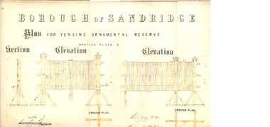
Plan - Fencing, Ornamental Reserve, Port Melbourne, 1879
Design of fensing (sic) for ornamental reserve (railway reserve) in Station Place North, 1879.Signed by Chas. Clay, Edward Wilson, E Clark, 1879.parks and gardens, engineering - fences, edward wilson, charles clay, edward clark, town clerks, railway reserve, station place -
 Port Melbourne Historical & Preservation Society
Photograph - Photograph board, Seven aerial views of J Kitchen & Sons site, Port Melbourne, J Kitchen & Sons Pty Ltd. Port Melbourne 1951, 1951
Large brown cardboard with seven (7) B&W aerial photographs pasted on it. Taken in 1951. Photo 1 - South East direction with Boundary Street in foreground, Kitchens buildings and Football Ground (cricket being played) Photo 2 - South West direction towards the Bay showing Station and Princes Piers, with ships in the distance. Photo 3 - almost directly above Kitchens Photo 4 - directly above kitchens Photo 5 - looking West including the Yarra River Photo 6 - looking North with Kitchen's storage and football ground in foreground Photo 7 - looking north east with football ground in foregrpound left and Yarra River top right.industry - manufacturing, built environment - industrial, piers and wharves - princes pier, piers and wharves - station pier, sport - australian rules football, sport - cricket, sport - recreational grounds, j kitchen & sons pty ltd, port melbourne football and cricket ground, north port oval -
 Ballarat Tramway Museum
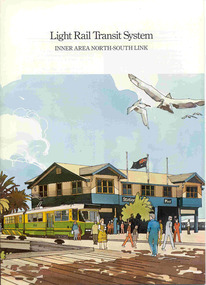
Book, Metropolitan Transit Authority (MTA), "Light Rail Transit System - Inner Area North-South Link", c1986
Sixteen page book, A4 portrait format, saddle stapled, titled "Light Rail Transit System - Inner Area North-South Link", published by the Metropolitan Transit Authority detailing the conversion of the former heavy electric suburban railway lines to St Kilda and Port Melbourne to electric trams or Light Rail. Has foreword by Tom Roper, Minister for Transport, Describes the proposed system, vehicles, development of articulated vehicles (2001, 2002), interchange with rail services, travel times and a map showing the proposed route, including a possible extension along Mitford St. and Broadway to Glenhuntly Road. Has a number of artists impressions of the vehicles at Station Pier and South Melbourne station. Includes colour photographs of the vehicles, conductors and photos of other light rail systems in Hanover and Amsterdam. Published c1986.trams, tramways, melbourne, light railways, mta, st kilda, port melbourne, articulated trams -
 Ballarat Tramway Museum
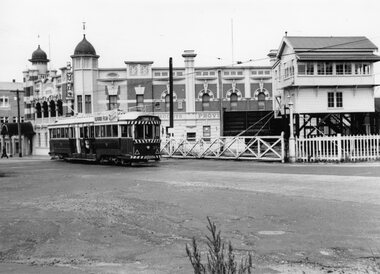
Photograph - Black & White Photograph/s, Wal Jack, 18/11/1961 12:00:00 AM
Yields information about Ballarat's trams in the late 1960'ss and the street scape in Victoria St?, Yields information about Ballarat's trams in the late 1960'ss and the street scape in Victoria St?Black and white print of Ballarat 35, northbound to Lydiard St North, crossing the Railway level crossing with Moodys Provincial Hotel and the Ballarat "B" signal box in the background. The tram has a roof advertisement for Ilford film. Note the entry canopy to the hotel. Two copies. Photo by Wal jack, 18/11/1961. Photo print courtesy of Port Dock Railway Museum, now the National Railway Museum. See worksheet 4311 for letter and details of prints sent to Bill Scott, 19/10/2001. Any photo credit to mention NRM Collection.On rear of copy 1 "SEC Ballarat / 35 / Lydiard St North / 18/11/61 2920 / Wal Jack " Copy 2 "DAC" in ink, bottom right hand corner.trams, tramways, lydiard st, ballarat railway station, level crossings, tram 35 -
 Queenscliffe Maritime Museum
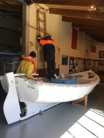
Vehicle - Workboat ex Wyuna
In 1974, this 18 foot (5.5 meter) diesel-powered workboat was one of the last boats built to operate from the pilot cutter Wyuna. These boats were used to transfer pilots from the Wyuna to the ship being serviced or vice versa. Until 1946 they were propelled by two oars then simplex two-stroke petrol engines were fitted followed by diesel engines. The Pilot Service Shipwrights built the boats in a shed which stood on the site of the present Pilot Station, Tobin Drive, North of Shortland Bluff. The design is based on a Gig and was developed by the Pilots as suitable for the severe conditions at the entrance to Port Phillip. To understand how these boats were used view the film "Through The Rip" on the video in the Exhibition Hall.Close association with QueenscliffTimber Workboat used to transfer pilots between Wyuna and ship requiring servicepilot service, wyuna, workboat, boat buiding, port phillip sea piots -
 Bayside Gallery - Bayside City Council Art & Heritage Collection
Map, Department of Crown Lands and Survey et al, Moorabbin, County of Bourke, Government Roads, 1920
The cadastral map of the Parish of Moorabbin in Victoria (L.6104) shows parish boundaries and land ownership 1920 when Sandringham was a Town. The government roads have been coloured in red pencil.moorabbin, county of bourke, map, plan, land subdivision, land titles, foreshores, hampton, beaumaris, highett, cheltenham, department of lands and survey, land owners, cartographic material, brighton, sandringham, town of sandringham, government roads -
 Bayside Gallery - Bayside City Council Art & Heritage Collection
Map, Department of Crown Lands and Survey, Moorabbin, County of Bourke, c. 1918
The cadastral map of the Parish of Moorabbin in Victoria (L.6104) shows parish boundaries and land ownership c. 1918 when Sandringham was a Borough.moorabbin, county of bourke, map, plan, land subdivision, land titles, foreshores, sndringham, hampton, beaumaris, highett, cheltenham, department of lands and survey, land owners, cartographic material, borough of sandringham, brighton -
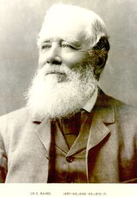 Port Fairy Historical Society Museum and Archives
Photograph, Cr S Baird 1867-68,1868-69,1870-71
Councillor Samuel Baird’s residence was the property known as ‘Warrong Station” north of Kirkstall. During the last year of his presidency he played an important part in obtaining the severance of the Shire of Minhamite from the Belfast Shire. Councillor Baird was the first president of the Minhamite Shire.Black and white portrait president, portrait, government, shire, municipal, local-government, minhamite shire, shire of belfast -
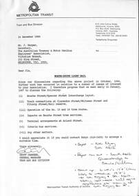 Melbourne Tram Museum
Letter, Metropolitan Transit Authority (MTA), "North - South Light Rail", 12/1986
Letter from Geoff Carkeek, MTA Tram and Bus Division General Manager to J Harper, Secretary ATMOEA dated 24/12/1986 regarding the North - South Light Rail proposal (St Kilda and Port Melbourne lines) and the conversion to light rail, and impacts on existing tram services. Includes a note on the proposed termination of route 15 and 16 trams at St Kilda Railway station. Includes two drawings - St Kilda Station - Fitzroy St using the former VR St Kilda station forecourt rather than the platforms which were actually later used, and Clarendon St - Port Junction layout.Yields information about the conversion of the St Kilda Railway project.Letter - photocoped - 6 A4 and 2 A3 folded sheets, part stapled.light rail, conversion, st kilda, port junction, atmoea, st kilda railway station -
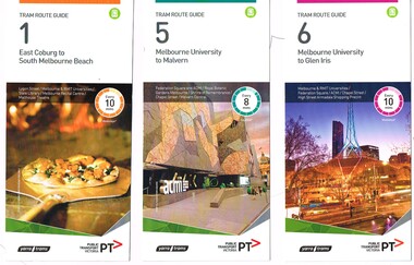 Melbourne Tram Museum
Ephemera - Tram Route Guides, Public Transport Victoria (PTV), "Tram Route Guide", Feb. 2016
Set of 18 Tram Route Guides, published during 2016. Each comprises a vertical DL folded sheet, full colour for the nominated routes, with Yarra Trams and PTV logos, listing the stops, interchanges with bus and other tram services, ticketing zones, estimated frequencies with adverts for Night tram services, TramTracker and Myki tickets. .1 - Route 1 - East Coburg to South Melbourne Beach .2 - Route 5 - Melbourne University to Malvern .3 - Route 6 - Melbourne University to Glen Iris .4 - Route 8 - Moreland to Toorak .5 -Route 57 - West Maribyrnong to Flinders St Station (2 copies) .6 - Route 70 - Wattle Park to Waterfront City Docklands .7 - Route 72 - Melbourne University to Camberwell .8 - Route 75 - Vermont South to Etihad Stadium / Bourke St Docklands .9 - Route 82 - Footscray to Moonee Ponds .10 - Route 19 - North Coburg to Flinders St Station .11 - Route 55 - West Coburg to Domain Interchange (two copies held) .12 - Route 59 - Airport West to Flinders St Station .13 - Route 30 - St Vincent's Plaza to Ethida Stadium Docklands .14 - Route 12 - Victoria Gardens to St Kilda / Fitzroy St .15 - Route 64 - Melbourne University to East Brighton .16 - Route 78 - North Richmond to Balaclava (via Prahran) .17 - Route 86 - Bundoora (RMIT) to Waterfront City Docklands .18 - Route 96 - East Brunswick to St Kilda Beach .19 - Route 11 - West Preston to Victoria Harbour Docklands ,20 - Route 16 - Melbourne University to Kew via St Kilda .21 - Route 48 - North Balwyn to Victoria Harbour Docklands .22 - Route 67 - Melbourne University to Carnegie .23 - Route 109 - Box Hill to Port Melbourne See Reg Item 2396 for 2012, 2939 for 2015 and 2940 for 2014 versions Items .13 to .18 added 2/9/18Item 11 has the "5" changed to "8" in Texta - see history of object.trams, tramways, timetables, maps, route 1, route 5, route 6, route 8, route 11, route 16, route 132, route 19, route 30, route 48, route 55, route 57, route 59, route 64, route 67, route 70, route 72, route 75, route 78, route 82, route 86, route 96, route 109, east coburg, west coburg, airport west, north coburg, south melbourne, malvern, glen iris, moreland, toorak, west maribyrnong, wattle park, docklands, camberwell, vermont south, footscray, moonee ponds, st vincent's plaza, victoria gardens, east brighton, north richmond, balaclava, bundoora, east brunswick, west preston, kew, north balwyn, carnegie, box hill -
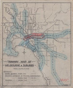 Melbourne Tram Museum
Drawing, H. S McComb, "Tramway Map of Melbourne & Suburbs", mid 1930's
Set of 19 drawings showing the development of the Melbourne tramway system between 1885 and 1921. Based on MMTB drawing "Tramway Map of Melbourne & Suburbs" P4609, 18 sheets showing year by year development of the cable and electric tram system, printed on off white paper. Mr. McComb had intended it would appear to do further work - with some 20 sheets printed on brown card paper but not used (.19 - same drawing) Each sheet has the year in red at the bottom right hand corner of the sheet. .1 - 1885 - with the Richmond line and main rail lines coloured in showing a catchment area. .2 - 1886 - shows the new cable line in Collins St and has a note that no suburban line constructed in 1886 .3 - 1887 - Bourke and northern lines and Brighton Beach to Sandringham and Hawthorn to Kew .4 - 1888 - Swanston St, Domain Road, Chapel and inner circle and towards Hurstbridge.\ .5 - 1889 - Rathdown St and Toorak Road .6 - 1890 - South and Port Melbourne, North Melbourne and Northcote. Rail lines - Ashburton and parts of the outer circle to Oakleigh. .7 - 1891 - St Kilda Esplanade and northern section of the outer circle. .8 - 1906 - NMETL .9 - 1910 - PMTT - High St and Wattletree Road .10 - 1911 - PMTT Dandenong Road .11 - 1913 - Glenferrie Road, Cotham Road, Balaclava and Glenhuntly Road .12 - 1914 - small extension in High St .13 - 1915 - Malvern Road and High St Kew .14 - 1916 - HTT and MBCTT lines and Whitehorse Road .15 - 1917 - Burke Road .16 - 1918 - Burke Road north of Camberwell station .17 - 1920 - FNPTT - St Georges Road and Plenty Road .18 - 1921 - Footscray lines .19 - base drawing only. Does not show the VR tramlines. See Reg Item 2154 for associated notes.See individual sheets.trams, tramways, times, cable trams, railways, tramways, melbourne, maps -
 Melbourne Tram Museum
Drawing, Melbourne & Metropolitan Tramways Board (MMTB), "Plan of Tramway System - showing route mileage of electric tramways", Late 1960's
Set of 9 A3 photocopy of a drawing - of a dyeline print that had been mounted onto a cloth backing and had been kept up to date with regard to extensions and closures or opening and closing - titled - "Plan of Tramway System - showing route mileage of electric tramways" - Principal Junctions and intersections shown diagrammatically. Map of system shown at 40 chains to the inch. Copy of Drawing No. P6050. Shows crossovers, signal cabins, automatic points, closed cable tram lines in the city area, Port Melbourne, roads, railways and stations. Has extensions to Mill Park up to April 1987. Shows the Port Melbourne, North Melbourne (Spencer and Abbotsford Sts) and Collingwood cable lines, the Footscray system lines and the Point Ormond lines. See also Reg Item 1561 for a late 1960's print and 3642 for a 1941 version.trams, tramways, mmtb, trackwork, tramways, junction, map -
 Melbourne Tram Museum
Album - Robert Thomson Slide Collection, AETA Convention 1970
Photo - see pdf file for further information. Number Brief Description RT091 Burke Road Camberwell south of the Junction but before Inglesby St. W7 No. 1007 Destination "Special". RT092 Riversdale Road Camberwell Junction - SW6 No. 933 - "City" - route 70 RT093 Miller Street outside the Preston Workshops - W2 No. 597 - "City - Spencer St" - route 9A RT094 West Maribyrnong Terminus SW6 No. 927 - "City via North Melb." - route 57 plus Y class No. 469 - "City" RT095 Queens Way St. Kilda. PCC No. 980 - "Special" RT096 Reserve track running alongside River St. Maribyrnong Y class No. 469 west bound - "Hawthorn Depot" RT097 Footscray Terminus Leeds Street Y class No. 469 - "Special" RT098 Brunswick Depot - various trams including W3 No. 657 - W5 No. 755 "Moreland" route 20 & W5 No. 732 "Moreland" route 15. RT099 North Fitzroy Depot AETA - buses 543, 551 & 583 All AEC Mk 3's RT100 Port Melbourne Station with four car "Harris" set. RT101 St Kilda Station with four car "Harris" set. RT102 Preston Workshops W2 No. 397 - route 01 (01 overhaul) plus another W2 and a Y1 RT104 Preston Workshops, W5 No 681 - not long after a repaint. RT105 Preston Workshops, Freight car No. 19 RT106 Preston Workshops, various cars of different classes. nearest is W5 No. 793 Route 03 (03 overhaul) Demonstrates the work of Robert Thomson in photography, collection and/or production of slidesAssembled album in a black presentation folder of 16 colour slides, collected or produced by Robert Thomson. All photographs have been scanned and placed on the Museum's G drive. A list of all photographs with details has been compiled. melbourne, tramways, trams, aeta, mmtb, preston workshops, miller st, footscray, leeds st, burke rd, west maribyrnong, camberwell junction, brunswick depot, north fitzroy depot, buses, mmtb buses, aec mk iii, w2 class, w3 class, sw6 class, w7 class, w5 class, tram 793, tram 19, tram 1007, tram 681, tram 397, tram 657, tram 469, y class, tram 980, pcc class, queens way, tram 933, riversdale road, camberwell, tram 755, tram 732, bus 543, bus 551, bus 583, port melbourne railway, railways, route 70, route 57, route 15, route 20, route 9a -
 Melbourne Tram Museum
Album - Robert Thomson Slide Collection, "Melbourne 14/9/91 to 21/9/91 16.11.1997 to 23.11.1997"
Photo - see pdf file for further information. Number Brief Description RT229 1997, Carlisle St, tram 129 - "Kew - Cotham Rd" - route 69 & tram 905 - "St Kilda Beach" - route 16 RT230 1997, Dandenong Rd, tram 86 - "Melbourne" - route 69 RT231 1997, Victoria Pde, tram 856 - "City Circle" - route 00 RT232 1997, Spring St, tram 909 - "City Circle" - route 00 RT233 1997, Swanston St, tram 982 - "University" - route 72 RT234 1997, Swanston St, tram 949 - "Glen Iris" - route 6 & tram 852 - "St Kilda Beach" - route 16 RT235 1997, Swanston St, tram 845 - "University" - route 16 RT236 1997, Swanston St, tram 951 - "?" - route 8 RT237 1997, Flinders St, tram 925 - "City Circle" - route 00 7 tram 2034 - "City La Trobe St" RT238 1997, Tram Defect, tram 98 RT239 1997, Flinders St Station, tram 785 - "?" - route 8 RT240 1997, Flinders St Station, tram 211 - "Moreland" - route ? RT241 Bourke St, tram 2059 - "City Spencer St"- route 87 RT242 St Georges Rd Preston, tram 1003 - "Preston" via St Georges Rd"- route 9 RT243 West Preston Terminus - tram 943 - "St Kilda Beach" - route 10 RT244 Princes Bridge , tram 950 - "City" - route 72 RT245 1997 Port Melb Ter, tram 265 - "Mont Albert" - route 109 RT246 1997 Port Melb Terminus RT247 1997 Port Melb Terminus, tram 285 - "Mont Albert" - route 109 RT248 North Balwyn Terminus, tram 244 - "City Lonsdale St" - route 48 RT249 1997 Bourke St mall, tram 2127 - "Bundoora RMIT" - route 86 RT250 1997 Bourke St mall, tram 2028 - "St Kilda Beach" - route 96 RT251 1997 Batman Ave, tram 239 - "Princes Bridge" - route 70 RT252 1997 Batman Ave Ter, tram 233 - "Wattle Park" - route 70 RT253 Princes Bridge , tram 960 - "City" - route 64 RT254 Swanston St at Flinders St, tram 776 - "Glen Iris" - route 6 & tram 809 - "Toorak" - route 8 RT255 Swanston St at Bourke St, tram 978 - "City" - route 64 RT256 Bourke St at Swanston St, tram 112 - "City" - route 86 RT257 South Melbourne Beach terminus, tram 818, - "East Coburg" - route 1 RT258 Carlisle St, tram 925 - "Kew Cotham Rd" - route 69 RT259 Acland St Terminus, tram 2018 - "East Brunswick" - route 98 RT260 St Kilda Rd Princes Bridge, "St Kilda Beach" - route 15 RT261 Batman Avenue Terminus, tram 24 "Special" & tram 22 - "Wattle park Elgar Rd" - route 70 RT262 Acland St Terminus, tram 646 - "City" - route 16 RT263 Bundoora Terminus - tram 2023 - "Bundoora" - route 86 Demonstrates the work of Robert Thomson in photography, collection and/or production of slidesAssembled album in a black presentation folder of 35 colour slides, collected or produced by Robert Thomson. All photographs have been scanned and placed on the Museum's G drive. A list of all photographs with details has been compiled. melbourne, tramways, trams -
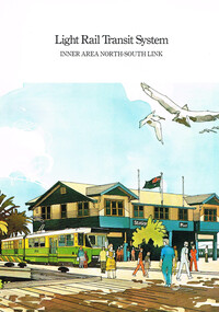 Melbourne Tram Museum
Pamphlet, Metropolitan Transit Authority (MTA), "Light Rail Transit System - Inner Area North - South Link", early 1987
Sixteen page, A4, full colour, printed on gloss paper, centre stapled pamphlet, titled "Light Rail Transit System - Inner Area North - South Link"", describing the proposal for the conversion of the St Kilda and Port Melbourne rail lines to light rail. Undated, Appears to be earlier than May 1987 (See Reg Item 457). Has a foreword by the Minister, Tom Roper, explains the system, shows high platform stops using the Hanover example, development of the project, journey times, costs and saving and two page map of the system, showing a possible extension to Glenhuntly Road. Has the Met contact and logo on the rear. Covers have a perspective view at Port Melbourne Station Pier. See Also Reg Item 457 for a similar pamphlet. 2nd copy added 23-10-2016trams, tramways, minister for transport, metropolitan transit authority, st kilda, port melbourne, light rail -
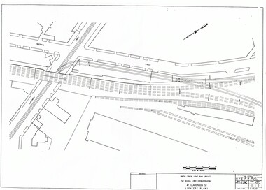 Melbourne Tram Museum
Drawing, Metropolitan Transit Authority (MTA), "North South Light Rail Project - St Kilda and Port Melbourne conversion - concept plans", Sep. 1986
Set of 20 A3 sheets titled "North South Light Rail Project - St Kilda and Port Melbourne conversion - concept plans", giving drawings for the conversion to Fitzroy St and Port Melbourne station. Prepared by the Metropolitan Transport Authority, Sept 1986, drawing numbers P15803 to P15822.trams, tramways, light rail, conversion, mta, construction -
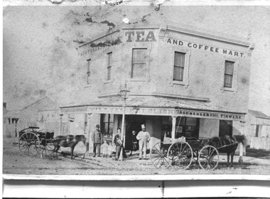 Port Melbourne Historical & Preservation Society
Photograph - William Dalglish shop, corner Station and Ingles Streets, Port Melbourne, 1874
Donated by the granddaughter of William DALGLISH.Faded black and white photo of the William DALGLISH shop at the corner of Station and Ingles Streets. Signage shows "North Sandridge Tea and Coffee Mart" and also Kitchenware, Ironmongery and Tinware. The photo taken in 1874 shows several people at the doorway of the shop and two horsedrawn wagons.william dalglish, business & traders - general stores, built environment - commercial -
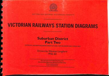 Victorian Railway History Library
Book, Langford, Weston, Victorian Railway Station Diagrams 1956-1960 - Suburban District Part Two, 1956-1960
Railway diagrams of the stations on the Clifton Hill, North Melbourne Port Melbourne & St Kilda group of lines in the Suburban district of Melbourne Victoria in 1956 to 1960.maps, p.52.non-fictionRailway diagrams of the stations on the Clifton Hill, North Melbourne Port Melbourne & St Kilda group of lines in the Suburban district of Melbourne Victoria in 1956 to 1960.railroad infrastructure - victoria, railroads - victoria