Showing 217 items matching "outbuildings"
-
 Glenelg Shire Council Cultural Collection
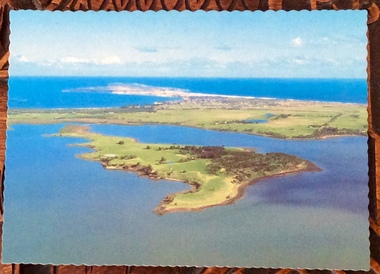
Postcard - Postcard - Maretimo Portland, Victoria, n.d
Coloured photo postcard, wavy edge. Aerial view of 'Maretimo' historic home, Portland. view shows main house and outbuilding plus gardensFront: 'Maretimo', PORTLAND, VICTORIA' printed in bright pink, top right Back: 'Short history of Maretimo' printed in brown, top left -
Stawell Historical Society Inc
Photograph, North Woodlands Outbuilding. Photographic Committee National Trust Photographs of Stawell
7006 National Trust Photographs North Woodlands OutbuildingSeries of Colour Photographs of buildings of interest to National TrustJune 1993buildings, heritage buildings -
 Phillip Island and District Historical Society Inc.
Photographs, Victoria Conservation Trust, Churchill Island, 1980s
3 coloured postcards and 8 coloured photographs of scenes on Churchill Island including an aerial view, homestead, outbuildings, vegetation, views, cairn and coastal scenes.Postcards say Churchill Island, Victoria. Victoria Conservation Trustchurchill island, churchill island heritage farm, churchill island - homestead, samuel amess -
 Whitehorse Historical Society Inc.
Photograph, Schwerkolt House, 1/11/1999 12:00:00 AM
Weatherboard Home, painted cream and green, built for Francesca Schwerkolt, C.1960's, Deep Creek Road, Mitcham. North elevation showing outbuilding.schwerkolt, francesca, deep creek road, mitcham -
 Lakes Entrance Historical Society
Photograph - Club Hotel, Holding M, 1999c
Colour photograph showing rear of the Club Hotel. White weatherboard building and corrugated iron roof. Random additions indicated by the form of the outbuildings. Lakes Entrance Victoriahotels, local history -
 Dutch Australian Heritage Centre Victoria
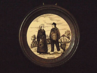
Round framed souvenir tile
Cream background with, in foreground, couple in dark brown regional Brabant costume; farmhouse with outbuildings and trees in background. Spring frame at rear for hanging. Brown imitation wood frame.Brabant at base of tile. -
 Whitehorse Historical Society Inc.
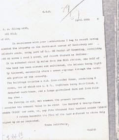
Legal record - Correspondence, Land valuation, 28/04/1988 12:00:00 AM
Valuation of land, North East corner of Canterbury and Middleborough Roads, part of C.A. Parish of Nunawading,Valuation of land, North East corner of Canterbury and Middleborough Roads, part of C.A. Parish of Nunawading, 44 acres, weatherboard house on property and outbuildings. Value 5,400 pounds.Valuation of land, North East corner of Canterbury and Middleborough Roads, part of C.A. Parish of Nunawading, land values, ellingworth, john roger, middleborough road, blackburn, canterbury road -
 Mt Dandenong & District Historical Society Inc.
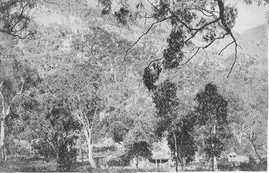
Photograph, View of Kalorama Gap 1905
Kalorama Gap viewed from the South West in 1908. Ellis Jeeves' 'Mountjoy' is in the centre with the stables to the left. The raspberry patch belongs to Harry Walker and the building centre right to Edward Joseph Price. John Lundy-Clarke grew up in the Kalorama/Mt Dandenong area and later in life (1972-74) began to write a comprehensive history of the area working from an original settlement map in an effort to cover all areas.Black and white photograph showing an extensive raspberry crop in the foreground with a house and outbuilding in the centre and another dwelling centre right. Handwritten description on reverse by John Lundy-Clarke. 1908 view of Kalorama Gap taken from corner of Village Settlement LOTS 2 and 3 on Ridge (then Main Road) which crosses centre of picture with Walker’s driveway dropping left. Walker’s raspberry patch in foreground. “Mountjoy” in centre of picture with coaching stables on left. Price’s house and shop on right showing large cross room used by the Village Settlers for dancing. Mrs Hand’s “Beulah Tearooms” later Mt Dandenong North Post Office is above Price’s roof.kalorama gap, kalorama, harry walker, walker, edward joseph price, raspberry, mountjoy -
 Lakes Entrance Historical Society
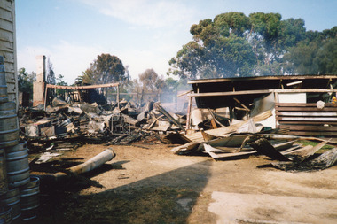
Photograph - Club Hotel, 2000
Date made December 2000Colour photograph showing remains of the Club Hotel, after the fire December 2000. Hotel building and outbuildings were destroyed. Background trees untouched. Lakes Entrance Victoriahotels, disasters -
 Greensborough Historical Society
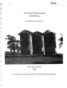
Booklet, Sera Jane Peters, Viewbank Homestead, Heidelberg: an historical survey, by Sera Jane Peters for Heritage Victoria, Department of Planning and Development, 1996
History of the Viewbank Homestead, originally a 90 acre site with homestead and outbuildings, now demolished.Black and white photocopy of typescript, with photographs, plans, reproductions of documents. 25 p plus 17 p of Appendices, unboundviewbank homestead, heritage victoria -
 Halls Gap & Grampians Historical Society
Photograph - B/W, C 1876
This cottage is said to have belonged to the Foulkes family. It was situated below Mackey's peak in the Fyans Valley. For further information see p. 77 of "Victoria's Wonderland".The photo shows a timber house and outbuilding set among bush below a line of cliffs. There is a spoked wheeled cart standing to the right of the house. The buildings are in the foreground at the lower edge of the photo.buildings, houses -
 Kew Historical Society Inc
Photograph - Former Kew Court House : Outbuildings, 1996
A civic campaign for new public offices developed in Kew in the 1880s. After much deliberation, the location chosen was the junction of Bulleen and Cotham Roads. The buildings were designed by George Watson and John Henry Harvey, architects within the Department of Public Works (Victoria). Building was commenced in 1887, and after one year, the buildings were opened. The Post Office was transferred to the new Commonwealth Government in 1901. The Police Station and Court House, sold by the Victorian Government to the City of Boroondara in 2007, are now a community cultural centre and performing arts venue.The buildings were listed on the Victorian Heritage Register Register (HO885) in 1991. They are historically and architecturally significant to the State of Victoria because Watson and Harvey's designs exhibit diversity in integrating civil offices, they accommodate the apex of road junctions, and they demonstrate a departure from the contemporaneously favoured High Victorian Classical to the Queen Anne style in the design of civic buildings.View of old weatherboard outbuildings, including a toilet, constructed in the formerly open area behind the Post Office, Court House and Police Station. In the distance is a wall of the former Post Office.kew court house, public offices -- kew (vic), kew police station, kew post office -
 Greensborough Historical Society
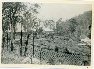
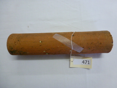
Pipe, Terracotta drain pipe (section), 1930c
Circa 1920-1940, this length of pipe was found in a Greensborough property near the site of a former outbuilding.An example of pipes no longer in use. Note small Internal diameter (4.5 cm).30 cm length of drain pipe. Terracotta. Orange colour with fragments of white rock. terracotta, pipe, greensborough, drains -
 Ringwood and District Historical Society
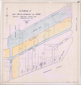
Map, Development of Right of Way Stage 2, Ringwood, Victoria - 1950
Borough Engineer's technical drawing for Development of Right of Way between Adelaide Street and Warrandyte Road, Ringwood, showing existing retail establishments and outbuildings, and area available for lock-up shops.Scale 20' = 1". ACR 11.7.50. (Alan Charles Robertson - Borough Engineer) -
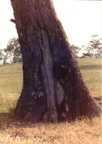 Hume City Civic Collection
Photograph, early 1990's
The set of 20 photographs were taken of a number of archaeological sites in Sunbury of sacred sites and aboriginal rings. The photographs were included in a study of these sites which was published by the Shire of Bulla in the early 1990's.A coloured photograph of a scarred tree trunk at Rupertswood estate. It is a close-up photograph of the lower section of the tree. There is a gentle rise behind the tree and two outbuildings along the hill top on the RHS.aboriginal ring sites, scarred trees, rupertswood estate, george evans collection -
 Surrey Hills Historical Society Collection
Photograph, 6a Thistle Street, Surrey Hills, 1924
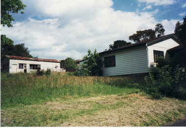
One of the oldest homes in Surrey Hills. The photo was taken in 1924 when the property was purchased by Mr John Francis Evans, father of Mrs Lillian Austin. The Evans family came from Gembrook. John Evans was born in Wales; he and his wife Mary had 3 children, 2 daughters and one son. Mary Evans pre-deceased her husband, who died on 23 October 1924 at Hillsborough, 6A Thistle Street. The first owner of the property was Mrs Rachel Sweetnam (nee Lewis) who married Thomas Edward Sweetnam on 24 September 1884 at St John's Church, Camberwell. REF: THE ARGUS 4 Oct 1884 Thomas second eldest surviving son of Matthew Sweetnam married to Rachel (Ray) third eldest daughter of Captain T.D. Lewis, Culm Haven, Camberwell. Thomas was active in land sales and variously described as a land agent, real estate agent and auctioneer. The property - Hillsboro or Hillsborough - was originally a house on a farm of 10 acres owned by her. It became 6A Thistle Street. According to the Alan Holt property register Rachel Sweetnam owned the property prior to 1890 and a family tree on Ancestry.com has that it was owned by her in c1886. It is likely that at this stage the property was an investment rather than the Sweetnam's family residence. Other property owners or residents are: 1890 Selina Gaylor 1900 Stephen Pullen 1910 William Murray (draftsman) 1920 George C Hughes 1930 Arthur Leslie Austin (tram driver) 1980 Mrs Lillian Evelyn Austin Lillian Austin died on 19 August 1983 and the property was sold that year for $87,000. The house is still extant (January 2025). Note that we also have material / photos regarding George Hughes and family.Black and white photo of a timber home with brick chimneys and a (?) corrugated iron roof. There are sheds and outbuildings attached to the house. The garden looks untended. In the background a mature eucalypt tree can be seen.houses, hillsboro, timber houses, mrs lillian austin, hillsborough, selina gaylor, stephen pullen, william murray, george hughes, arthur austin, john francis evans, thistle street -
 Kew Historical Society Inc
Photograph - Former Kew Court House : Outbuildings, 1996
A civic campaign for new public offices developed in Kew in the 1880s. After much deliberation, the location chosen was the junction of Bulleen and Cotham Roads. The buildings were designed by George Watson and John Henry Harvey, architects within the Department of Public Works (Victoria). Building was commenced in 1887, and after one year, the buildings were opened. The Post Office was transferred to the new Commonwealth Government in 1901. The Police Station and Court House, sold by the Victorian Government to the City of Boroondara in 2007, are now a community cultural centre and performing arts venue.The buildings were listed on the Victorian Heritage Register Register (HO885) in 1991. They are historically and architecturally significant to the State of Victoria because Watson and Harvey's designs exhibit diversity in integrating civil offices, they accommodate the apex of road junctions, and they demonstrate a departure from the contemporaneously favoured High Victorian Classical to the Queen Anne style in the design of civic buildings.Photograph of the rear of the former Kew Post Office, Court House, and Police Station showing outbuildings constructed within the formerly open court yard. These were service buildings for the workers in the Police Station.kew court house, public offices -- kew (vic), kew police station, kew post office -
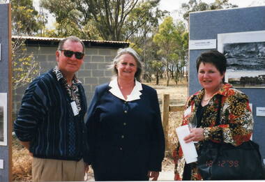 Sunbury Family History and Heritage Society Inc.
Photograph, Veronica Burgess, Alister Clark Rose Garden, 12th December 1999
Trevor and Margaret Dunn and Sue Barnett are the three people who were invited to attend the official opening of the Alister Clark Rose Garden in Bulla on the 12th December 1999. At the time Sue Barnett was the curator at the George Evans Museum in Sunbury and Margaret and Trevor worked there as volunteers.A non-digital photograph of two ladies and a man standing in a garden at an official function. A display board with photographs is behind one of the ladiesehind one of the ladies and a small grey cement brick outbuilding is in the background.alister clark memorial rose garden, bulla, trevor dunn, margaret dunn, sue barnett -
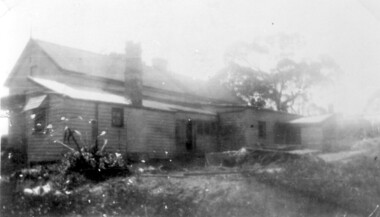
 Sunbury Family History and Heritage Society Inc.
Photograph, Rosa McCall, Wooden Outhouse, 25th February 1998
... Outbuildings ...The wooden outhouse was erected in the former Sunbury Asylum grounds and was a popular outdoor building where the patients and staff relaxed while walking around the grounds.Patients were encouraged to spend time outdoors and the extensive and elevated grounds provided plenty of space. The photograph was included in a collection that was put together for a photograph competition organised by the former Sunbury & District Heritage Association in March 2001.A non-digital coloured photograph of a wooden and corrugated iron outhouse with a trellis covering half of a wall. Two large cypress trees are behind the building.sunbury asylum, outbuildings, sunbury -
 Tarnagulla History Archive
Photograph of police buildings in Tarnagulla, Police buildings in Tarnagulla, 31st January 1924
Murray Comrie Collection. The buildings in this image are (from left to right) the lockup, stable and office of the Tarnagulla Police complex. At far left a small part of the rear of the policeman's residence is visible. This residence is clearly depicted in THA-2019.0030. Behind the residence and outbuildings (in background of this photo) was an adjoining paddock for the police horses. This town block was the base for policing in Tarnagulla from 1878 until the 1990s. At the time of this photo (1924), Angus Comrie Snr was the constable for Tarnagulla, living at the police residence with his family. The residence was sold for removal in in the 1960s and replaced with a prefabricated residence and small office from Bealiba which were used until the 1990s. These as well as the lockup are still in place (as of 2019) on the corner of Victoria and Gladstone Streets. There are now private residences built on the former police horse paddock. For over 100 years the Comrie name has been involved with the Victoria Police. Angus Comrie Snr, joined the force in 1899 and served as constable in Kaniva and Avoca and then in Tarnagulla from late 1909 until 1927. His son Murray Comrie, born in Tarnagulla in 1912 also became a policeman and later a Chief Superintendent, retiring in 1972 and passing away in 1983 after a long illness. Murray Comrie's son Murray Jnr., to avoid confusion became known by his middle name, Neil. Neil Comrie also joined Victoria Police and and rose through the ranks to become Chief Commissioner of Victoria Police from 1993 to 2001. The Murray Comrie Collection held by Tarnagulla History Archive was collated in the 1970s by Murray Comrie (1912-1983).Sepia photographic postcard, image depicting members of the Angus Comrie family standing among police outbuildings in Tarnagulla. Based on the note on reverse of THA-2019.0030, the subjects are probably (left to right): Hilda Comrie (b.1904, married in1907 to Alf Clarke), Roy Comrie (b.1921), Keith Comrie (b.1911, d.1934) and either Angus Comrie Jr. (b.1909) or Murray Comrie (b. circa 1912). See second image for handwritten notes on reverse.tarnagulla, police, policing, comrie -
 Greensborough Historical Society
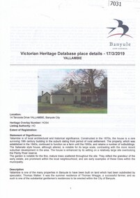
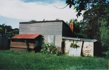
Article, Banyule City Council, Victorian Heritage database place details: Yallambie, 17/03/2019
Victorian Heritage Database entry (Banyule Heritage Study 1985) giving a detailed description of Yallambie house, outbuildings and remnant trees.Black & white text with col. photograph, printed both sides.yallambie homestead -
Glenelg Shire Council Cultural Collection
Photograph - Photograph - Portland, Victoria, 1940s
Black and white photo . Group of old buildings, back view, bluestone, pitched roof, skylights, small outbuildings, inside wooden fence, another building with verandah, outside fence. Car on right of photo.historic buildings, portland street scene -
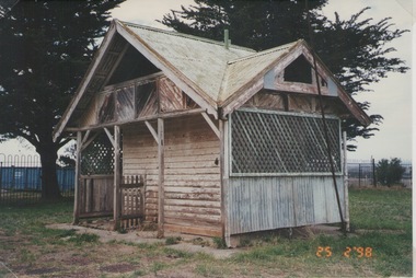
 Halls Gap & Grampians Historical Society
Photograph - Coloured, C 2000s
This is the building that was used as a bakery in the 1940s.A galvanised iron structure with a lower stone outbuilding at the side and a rusting galvanised iron lean-to at the front. The building has a brick chimney and an old, white window is leaning against the front of the stone portion of the building.buildings, bakery -
 Halls Gap & Grampians Historical Society
Photograph - B/W, c 1844
This property was known as Mokepilly Station ( name on back of photo is spelt 'Mokepilli'.For further reference see p.2,p.92,116,119,121, Victoria's Wonderland.Photo shows a body of water in foreground with a collection of buildings on opposite bank. there are a number of large gum trees on both sides of water. The buildings appear to be a farmhouse and outbuildings that have thatched roofs. There is extensive fencing.buildings, houses -
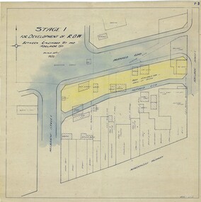 Ringwood and District Historical Society
Map, Development of Right of Way Stage 1, Ringwood, Victoria - 1950
Borough Engineer's technical drawing for Development of Right of Way between Ringwood Street and Adelaide Street, Ringwood, showing existing recreation reserve, retail establishments, outbuildings, and area available for lock-up shops.Scale 20' = 1". ACR 10.7.50. (Alan Charles Robertson - Borough Engineer) -
 Lakes Entrance Historical Society
Photograph - Club Hotel Fire, LERHS, 2000
Date made December 2000Colour photograph showing smouldering debris that was the Club Hotel. Photograph taken from rear, partially destroyed outbuildings. Fire truck in taped off area. Mown lawns in foreground. Lakes Entrance Victoriahotels, fire brigade, disasters -
University of Melbourne, Burnley Campus Archives
Plan - Photocopy, County [of Bourke], c.1930
Given to Archives by Emma Ferguson and Jo van Berkel who used it in preparation of their 1994 thesis on the history of the Burnley Gardens. Photocopy of a plan depicting Burnley College as it was in the 1930's. It shows the Pavilion and surrounding gardens, coops and yards, various small outbuildings. Shows the contours of the land in the northern section of the property bordering Swan St. Some additions and comments have been added to original document, mainly to do with sewerage and water supplyburnley college, pavilion, emma ferguson, jo van berkel, orchard, water supply -
Glenelg Shire Council Cultural Collection
Map - Map - Paper Survey, n.d
Paper survey map, ink and watercolour, framed under glass. Painted black gloss. Shows Fawthrop lagoon and surrounds including Fawthrop's home 'Windsor Cottage', outbuildings and garden, Cairncross and Howard holdings and othersBack: 'Town of Portland' -
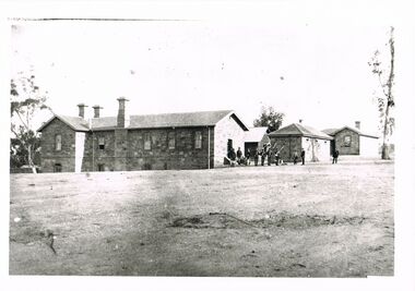 Bendigo Historical Society Inc.
Photograph - WES HARRY COLLECTION: POLICE BARRACKS
black and white image/copy Police Barracks, Rosalind Park. Two storey stone building, three chimneys and three outbuildings. Group of policemen with rifles on the right hand side of image. Early photo - possibly c1860's.place, bendigo, police barracks, bendigo, police barracks, sandhurst -
Warrnambool and District Historical Society Inc.
Functional object - Battery-operated lantern, c. 1950
This small portable lantern would have been used when camping or in a room or outbuildings to provide a small amount of light, perhaps similar to the light provided by a torch today.This item is retained for display purposes. This is a lantern with a metal base, a funnel-shaped column and a white perspex top covering a light. The column and base have a metal handle attached by a screw. Under the base is a metal covering which opens to a space that held a battery (now missing). The bottom metal lid is now detached. The base and column have been painted red but they are now quite rustedvintage lighting, warrnambool history