Showing 65 items
matching peak hill
-
 Flagstaff Hill Maritime Museum and Village
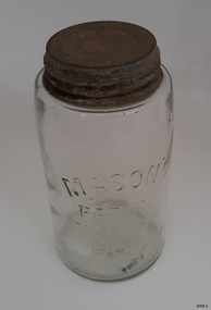
Container - Fruit Preserving Jar, John Landis Mason, 1858-1910
The Masons patent of Nov 30th, 1858 phrase was originally embossed on countless glass fruit jars and canning jars, most ranging in age from circa 1858 to the mid-1910s. John Landis Mason was awarded patent No 22186, issued on November 30, 1858, by the U.S. Patent & Trademark Office it was termed an "Improvement in screw-neck bottles", for his invention concerning the process of creating a threaded screw-type closure on bottles and jars. Similar screw-threading had been done before on some bottles, but the process of forming the upper lip area of the container so that it was smooth, even, and sturdy enough for a lid of standard size to be screwed thereon was difficult and expensive to do properly, often with unsatisfactory results. His improvement revolutionized home canning in the United States and many other countries. In any case, throughout the next 60-odd years, production of jars with the Nov. 30, 1858 embossing continued at a high rate, with untold tens of millions being produced. The phrase was soon considered an important marketing device, adding to the perception of quality and reliability of the container to the average consumer. This perception continued to at least 1879 21 years after the patent was issued, nearly every glass bottle factory was likely producing their version. The 1880s and 1890s likely saw the peak of popularity of these jars. A considerable percentage have a mold number or letter on the base, a means of identifying the particular mold in use at the factory.An early item used in most kitchens by women who preserved fruit and vegetables before the arrival of refrigeration giving a snapshot into the domestic lives of families during the late 19th to early 20th century's and how they preserved food for later use without refrigeration. Preserving jar, glass, with metal screw top lid. Glass has side seams, impurities and slightly concave base. It has been hand blown into a mould. Inscription is moulded into glass. Moulded into glass: MASON'S / PATENT / NOV 30TH / 1838"warrnambool, flagstaff-hill, flagstaff-hill-maritime-museum, maritime-museum, shipwreck-coast, flagstaff-hill-maritime-village, food preserving, mason jar, john landis mason, domestic container, glass jar, fruit & vegetable jar, domestic jar, food preparation, handmade glass, blown glass -
 Flagstaff Hill Maritime Museum and Village
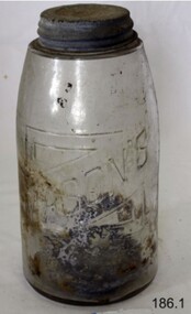
Container - Fruit Preserving Jar, John Landis Mason, 1858-1910
The Masons patent of Nov 30th, 1858 phrase was originally embossed on countless glass fruit jars and canning jars, most ranging in age from circa 1858 to the mid-1910s. John Landis Mason was awarded patent No 22186, issued on November 30, 1858, by the U.S. Patent & Trademark Office it was termed an "Improvement in screw-neck bottles", for his invention concerning the process of creating a threaded screw-type closure on bottles and jars. Similar screw-threading had been done before on some bottles, but the process of forming the upper lip area of the container so that it was smooth, even, and sturdy enough for a lid of standard size to be screwed thereon was difficult and expensive to do properly, often with unsatisfactory results. His improvement revolutionized home canning in the United States and many other countries. In any case, throughout the next 60-odd years, production of jars with the Nov. 30, 1858 embossing continued at a high rate, with untold tens of millions being produced. The phrase was soon considered an important marketing device, adding to the perception of quality and reliability of the container to the average consumer. This perception continued to at least 1879 21 years after the patent was issued, nearly every glass bottle factory was likely producing their version. The 1880s and 1890s likely saw the peak of popularity of these jars. A considerable percentage have a mold number or letter on the base, a means of identifying the particular mold in use at the factory.An early item used in most kitchens by women who preserved fruit and vegetables before the arrival of refrigeration giving a snapshot into the domestic lives of families during the late 19th to early 20th century's and how they preserved food for later use without refrigeration. Preserving glass jar. Glass lip with metal screw top lid. Inscription pressed into glass."Mason's Patent Nov 30th 1858"warrnambool, flagstaff-hill, flagstaff-hill-maritime-museum, maritime-museum, shipwreck-coast, flagstaff-hill-maritime-village, food preserving, mason jar, john landis mason, domestic container, glass jar, fruit & vegetable jar, food storage, preserving jar -
 Williamstown High School
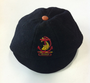
School cap, J.T. Lynch
Black felted wool peaked cap with green wool under peak. Red button (faded to tan) on top. Logo with fish and anchor and 'Hold fast' in red and yellow.Inside hat: Made specially for Williamstown High School by J.T. Lynch, Moonee Ponds Name: Ray Hill IIIB Size: 7williamstown high school, cap, school uniform -
 Whitehorse Historical Society Inc.
Article, Beatrice or Valley, 1967
Article in Nunawading Gazette re objections to the name Beatrice Court. Objectors would like the name changed to Valley Court, Forest Hill.[actually in Blackburn]Article in Nunawading Gazette re objections to the name Beatrice Court. Objectors would like the name changed to Valley Court, Forest Hill.[actually in Blackburn]Article in Nunawading Gazette re objections to the name Beatrice Court. Objectors would like the name changed to Valley Court, Forest Hill.[actually in Blackburn]street names, city of nunawading, beatrice court, blackburn, peak court, blackburn -
 Ballarat Heritage Services
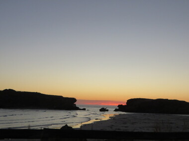
Photograph - Colour, Clare Gervasoni, Sunset Looking Towards Middle Island, Warrnambool, 2016, 24/12/2016
The Middle Island Maremma Project began in 2006 when there was a sharp decline in the colony size of Little Penguins on Middle Island due to fox predation. Maremma Guardian dogs were trained and placed on Middle Island to protect the penguins from foxes during the breeding season. The Project has been a huge success, with no evidence of fox attacks since the beginning of the Project and a steady increase in penguin colony size from fewer than 10 birds in 2005 to an estimated peak number of 180 penguins in 2013.Colour photographs looking towards Middle Island, Warrnambool.middle island, warrnambool, beach, sunset, maremma, little pengion -
 Ballarat Heritage Services
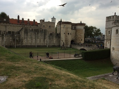
Digital photograph, Dorothy Wickham, Tower of London, 2016
The Tower of London, officially Her Majesty's Royal Palace and Fortress of the Tower of London, is a historic castle located on the north bank of the River Thames in central London. It lies within the London Borough of Tower Hamlets, separated from the eastern edge of the square mile of the City of London by the open space known as Tower Hill. It was founded towards the end of 1066 as part of the Norman Conquest of England. The White Tower, which gives the entire castle its name, was built by William the Conqueror in 1078, and was a resented symbol of oppression, inflicted upon London by the new ruling elite. The castle was used as a prison from 1100 (Ranulf Flambard) until 1952 (Kray twins),[3] although that was not its primary purpose. A grand palace early in its history, it served as a royal residence. As a whole, the Tower is a complex of several buildings set within two concentric rings of defensive walls and a moat. There were several phases of expansion, mainly under Kings Richard the Lionheart, Henry III, and Edward I in the 12th and 13th centuries. The general layout established by the late 13th century remains despite later activity on the site. The Tower of London has played a prominent role in English history. It was besieged several times, and controlling it has been important to controlling the country. The Tower has served variously as an armoury, a treasury, a menagerie, the home of the Royal Mint, a public record office, and the home of the Crown Jewels of England. From the early 14th century until the reign of Charles II, a procession would be led from the Tower to Westminster Abbey on the coronation of a monarch. In the absence of the monarch, the Constable of the Tower is in charge of the castle. This was a powerful and trusted position in the medieval period. In the late 15th century the castle was the prison of the Princes in the Tower. Under the Tudors, the Tower became used less as a royal residence, and despite attempts to refortify and repair the castle its defences lagged behind developments to deal with artillery. The peak period of the castle's use as a prison was the 16th and 17th centuries, when many figures who had fallen into disgrace, such as Elizabeth I before she became queen, Sir Walter Raleigh, and Elizabeth Throckmorton were held within its walls. This use has led to the phrase "sent to the Tower". Despite its enduring reputation as a place of torture and death, popularised by 16th-century religious propagandists and 19th-century writers, only seven people were executed within the Tower before the World Wars of the 20th century. Executions were more commonly held on the notorious Tower Hill to the north of the castle, with 112 occurring there over a 400-year period. In the latter half of the 19th century, institutions such as the Royal Mint moved out of the castle to other locations, leaving many buildings empty. Anthony Salvin and John Taylor took the opportunity to restore the Tower to what was felt to be its medieval appearance, clearing out many of the vacant post-medieval structures. In the First and Second World Wars, the Tower was again used as a prison, and witnessed the executions of 12 men for espionage. After the Second World War, damage caused during the Blitz was repaired, and the castle reopened to the public. Today the Tower of London is one of the country's most popular tourist attractions. Under the ceremonial charge of the Constable of the Tower, it is cared for by the charity Historic Royal Palaces and is protected as a World Heritage Site.(Wikipedia) A World Heritage Site is a landmark which has been officially recognized by the United Nations, specifically by UNESCO. Sites are selected on the basis of having cultural, historical, scientific or some other form of significance, and they are legally protected by international treaties. UNESCO regards these sites as being important to the collective interests of humanity. More specifically, a World Heritage Site is an already classified landmark on the earth, which by way of being unique in some respect as a geographically and historically identifiable piece is of special cultural or physical significance (such as either due to hosting an ancient ruins or some historical structure, building, city, complex, desert, forest, island, lake, monument, or mountain) and symbolizes a remarkable footprint of extreme human endeavour often coupled with some act of indisputable accomplishment of humanity which then serves as a surviving evidence of its intellectual existence on the planet. And with an ignoble intent of its practical conservation for posterity, but which otherwise could be subject to inherent risk of endangerment from human or animal trespassing, owing to unmonitored/uncontrolled/unrestricted nature of access or threat by natural or accelerated extinction owing to local administrative negligence, hence it would have been listed and demarcated by the United Nations Educational, Scientific and Cultural Organization (UNESCO) to have been identified or recognised and officially christened and internationally elevated through multilateral declaration by UNESCO as a universally protected zone. [1] The list is maintained by the international World Heritage Programme administered by the UNESCO World Heritage Committee, composed of 21 UNESCO member states which are elected by the General Assembly. (Wikipedia)The Tower of London is a UNESCO world heritage site.tower of london -
 Ballarat Tramway Museum
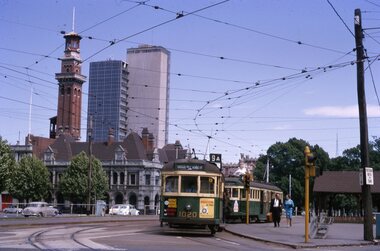
Slide - 35mm slide/s - set of 11, Noel Simons, 23/10/1965 12:00:00 AM
Set of 11 Kodachrome transparencies taken on 23/10/1965 in Melbourne. 1178.1 - W7 1020 (on route 9A, Northcote via St Georges Road) with a W2 536 (Deepdene) behind at the corner of Victoria Parade and Brunswick St. East Melbourne or Fitzroy. Has Eastern Hill fire station and ICI building in background. 1020 has front dash panel ads for Queens Bridge Motors and Bridgestone tyres. 1178.2 - W5 759 (route 19, North Coburg) and W5 807 in Elizabeth St. Melbourne at the intersection of Bourke St. with the State Savings Bank building in the background. 759 has side ads, one of which is for CASTROL. 1178.3 -SW6 903 crossing Brunswick St. in Victoria Parade, Fitzroy bound for Deepdene, route 45. Photo taken after tram has passed photographer. 1178.4 - W7 1019 (route 96, East Brunswick Blyth St.) and W7 1010 (route 88 East Preston) in Nicholson St at intersection with Victoria Parade. A Herald newspaper truck is alongside 1019. 1178.5 - W7 1040 (route 96, East Brunswick Blyth St.) in Nicholson St at intersection with Albert St. Has Princess Theatre in the background. (High res scan added 26/10/2008 - copy to FOHTD) .1178.6 - W6 974 (route 89 East Preston Bell St.) in Bourke St. about to turn into Spring St. Has buildings on the south side of Bourke St in background, including Southern Cross Hotel. Note trees in tubs and red phone box by Windsor Hotel. 1178.7 - as for same location as 1178.6 - SW6 967 (route 96) and W6 971 (inbound - route 90 - City Spencer St.) 967 has Lucas ad on front dash. 1178.8 - W7 1013 (route 88 East Preston) photographed from W6 991 in Bourke St at corner of Russell St. Has Normans corner store, Treadways and Foys in background. 1178.9 - W2 553 (route 1 East Coburg) at the corner of Elizabeth St and Bourke St. Has the Leviathan, Roger David and Ezywalkin shops in the background. 1178.10 - W6 991 (route 88) and W7 (route 96) in Bourke St. at corner with Elizabeth St. Photo taken from the GPO steps. 991 has ads for BIC pens and CASTROL. In background are the State Savings Bank, Halls Books and McEwans shops. 1178.11 - Line up of north bound trams (3 +) lead by W2 449and southbound in Elizabeth St at corner of Collins St. Has Flinders St. station building in the background. Hi -res image of .10 added 22-12-2018All have date stamp of "23 Oct 1965" in purple ink. All black ink unless otherwise noted. 1178.1 - "W7 1020 turning into Brunswick St. from Victoria parade, East Melbourne (followed by W2 536) 1178.2 - "W5 799 and 807 in Elizabeth St. Melbourne at cnr. of Bourke St." 1178.3 - "SW6 903 entering reserved track in Victoria Parade, East Melbourne" 1178.4 - "W7 1019 and 1010 in Nicholson St. East Melbourne at Victoria Pde intersection" 1178.5 - "W7 1040 Melbourne's last tram (to date) in Nicholson St. at Albert St. intersection." 1178.6 - "W6 974 in Bourke St. Melbourne, about to turn into Spring St." 1178.7 - "W6 971 entering Bourke St. from Spring St. Melbourne, passes SW6 967 outward bound for East Brunswick" 1178.8 - "W7 1013 (seen from W6 991) in Bourke St. Melbourne crossing Russell St." 1178. 9 -"W2 553 in Elizabeth St. Melbourne at cnr of Bourke St." 1178.10 - "W6 991 and W7 1005 in Bourke St. Melbourne at cnr of Elizabeth St." 1178.11 - "W2 449 leads a line of Peak hour cars along Elizabeth St. Melbourne (at Collins St. corner)"tramways, trams, melbourne, victoria parade, nicholson st., brunswick st., bourke st, elizabeth st, tram 1020, tram 536, tram 799, tram 807, tram 903, tram 1019, tram 1010, tram 1040, tram 974, tram 967, tram 971, tram 1013, tram 553, tram 991, tram 1005, tram 449 -
 Ballarat Tramway Museum
Ephemera - Tour Notes, Victorian Railways et al, ARE/ARHS/AREA (Vintage Train) Tour to Ballarat, Sep. 1971
Set of three foolscap size sheets, for ARE/ARHS/AREA (Vintage Train) Tour to Ballarat, on Sunday 5 September 1971, the last day of the Mount Pleasant, Gardens Via St. West Lines. 1. - Welcome Aboard circular - printed both sides on pink paper - which involved the running of two trains, special bus and tram arrangements at Ballarat, for the visit to Sovereign Hill. Gives details of the tram timetables, for the afternoon, train departure times, lunch arrangements and notes on bus and tram running if peak loads encountered. 2nd copy ex Peter Winspur, added 11/1/2007. 2. Victorian Railways S Circular, or special train notice, S2188/71, three pages giving list of special trains, altered platform arrangements at Flinders St., train schedules, alterations to goods trains, light engine movements, loads, motive power and tickets. Signed by J.C. Crute as Chief Traffic Manager. Dated 27/8/1971. See Reg Item 3442 for the booking circular and form. Images of document added 27-08-12.Notes on page 2 by W.Doubleday of trams operating and some notes.arhs, are, area, ballarat, special trains -
 Otway Districts Historical Society
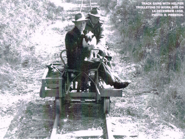
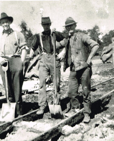
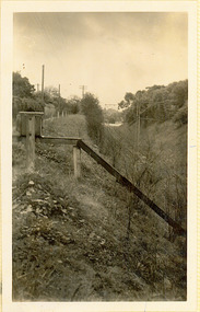
Photograph, R. Preston, Trolleying to work site, 1955, 14 December 1955
At its peak the Beech Forest railway employed more than 21 staff between Colac and Crowes. Gangers (men in charge of the track gangs) tended to be promoted into the Otways but many of their subordinate repairers were local recruits. A few of the men who worked in the original construction gangs of 1900-1902 remained and obtained positions in the track gangs along the line. The track was maintained by seven three-man gangs based at Colac, Barongarook, Gellibrand, Banool, Beech Forest (2), and Lavers Hill. However, track gangs lessened as the line shortened. After 1954, the sole surviving track gang, in charge of Paddy Balcombe, stayed until the line closed.A railway track gang, with helper, trolleying to a work site, on 14 December, 1955.beech forest; railways; track gang; -
 Otway Districts Historical Society
Photograph, Barongarook track gang, c.1925, c.1925
At its peak the Beech Forest railway employed more than 21 people between Colac and Crowes tending the line the trains ran over. The gangers (the men in charge of the track gangs) tended to be promoted into the Otways but many of their subordinate repairers were local recruits. A few of the men who worked on the original construction gangs of 1900-1902 remained and obtained positions in the track gangs along the line. The track was maintained by seven three-man gangs based at Colac, Barongarook, Gellibrand, Banool, Beech Forest (2), and Lavers Hill. The ganger for Beech Forest 2 gang resided at Wyelangta. However, the track gangs lessened as the line shortened. Three men with spades on the line, thought to be at Barongarook, c.1925. B/W.barongarook; railways; track gangs; -
 Tennis Australia
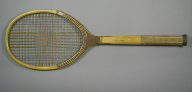
Racquet, Circa 1932
A wooden racquet with blue, red, green, and yellow whipping, green end wrap and butt cover ,twine stringing with distinct sweet-spot, and a grooved handle. Inscription across throat of obverse: BEVERLY HILLS. Decal trademark featured across throat on reverse, comprising of an encircled racquet presented behind two ribbon devices. Inscription: C.L.GODFREY/THE PEAK/OF QUALITY/TRADE MARK/PAWTUCKET,/R.I. Materials: Wood, Twine, String, Ink, Leather, Cloth, Metal, Glue, Lacquertennis -
 Tennis Australia
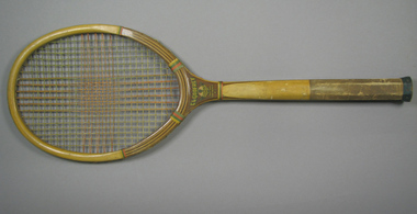
Racquet, Circa 1932
A wooden racquet with blue, red, green, and yellow whipping, green end wrap and butt cover, twine stringing with distinct sweet-spot, and a grooved handle. Inscription across throat of obverse: BEVERLY HILLS. Decal trademark featured across throat on reverse, comprising of an encircled racquet presented behind two ribbon devices. Inscription: C.L.GODFREY/THE PEAK/OF QUALITY/TRADE MARK/PAWTUCKET,/R.I. Materials: Wood, Twine, String, Ink, Leather, Cloth, Metal, Glue, Lacquertennis -
 Kew Historical Society Inc
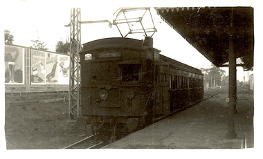
Photograph - The last train at Barker Station, 1952
The Kew railway was opened in 1887, and diverged from the main (Box Hill–Lilydale) line about half-way between Hawthorn and Glenferrie. From the point of divergence the line was slightly less than one mile long, and it had only one intermediate station — Barker. There were four road over-bridges and two level crossings, including one over the busy Barkers Road. The line supported a passenger and goods service, and was electrified in December 1922, at the same time as the main line to Box Hill. There were a number of peak hour services which ran from Flinders Street station (Melbourne) to Kew, but in 1938 all but one of these were diverted to the Ashburton line, where traffic was growing. This had an adverse effect on Kew traffic, as passengers from Kew needed to cross over a footbridge at Hawthorn to change trains, and the main line trains were usually already crowded by the time they reached Hawthorn. At about the same time the off-peak trains were replaced by road buses. In 1952 all passenger trains were withdrawn, but the road bus service continued for many years. Goods trains were finally withdrawn in 1957, and the railway was dismantled in 1958-59. (Source: Frank Stamford, 'The Hawthorn - Kew Railway')Small black and white snapshot of the last passenger train at Barker Railway Station in 1952. The photograph, one of 12, is part of a larger album of newspaper clippings, timetables, tickets and photos relating to the Kew Railway Line, taken and compiled by Lachlan Richardson, while a resident of Kew. The album dates from the 1950s. The album is part of a larger subject file on the Kew Line, compiled over time by members of the Kew Historical Society."Last train at Barker Station / 1 August 1952"kew railway line, transport -- railways -- kew (vic.), barker railway station, kew branch line -
 Kew Historical Society Inc
Photograph - Barker Station, August 1952
The Kew railway was opened in 1887, and diverged from the main (Box Hill–Lilydale) line about half-way between Hawthorn and Glenferrie. From the point of divergence the line was slightly less than one mile long, and it had only one intermediate station — Barker. There were four road over-bridges and two level crossings, including one over the busy Barkers Road. The line supported a passenger and goods service, and was electrified in December 1922, at the same time as the main line to Box Hill. There were a number of peak hour services which ran from Flinders Street station (Melbourne) to Kew, but in 1938 all but one of these were diverted to the Ashburton line, where traffic was growing. This had an adverse effect on Kew traffic, as passengers from Kew needed to cross over a footbridge at Hawthorn to change trains, and the main line trains were usually already crowded by the time they reached Hawthorn. At about the same time the off-peak trains were replaced by road buses. In 1952 all passenger trains were withdrawn, but the road bus service continued for many years. Goods trains were finally withdrawn in 1957, and the railway was dismantled in 1958-59. (Source: Frank Stamford, 'The Hawthorn - Kew Railway')Small black and white snapshot of the last passenger train at Barker Railway Station in 1952. The photograph, one of 12, is part of a larger album of newspaper clippings, timetables, tickets and photos relating to the Kew Railway Line, taken and compiled by Lachlan Richardson, while a resident of Kew. The album dates from the 1950s. The album is part of a larger subject file on the Kew Line, compiled over time by members of the Kew Historical Society."Barker Station / August 1952"kew railway line, transport -- railways -- kew (vic.), barker railway station, kew branch line -
 Kew Historical Society Inc
Photograph - Kew Railway Station: Denmark Street entrance, 1952
The Kew railway was opened in 1887, and diverged from the main (Box Hill–Lilydale) line about half-way between Hawthorn and Glenferrie. From the point of divergence the line was slightly less than one mile long, and it had only one intermediate station — Barker. There were four road over-bridges and two level crossings, including one over the busy Barkers Road. The line supported a passenger and goods service, and was electrified in December 1922, at the same time as the main line to Box Hill. There were a number of peak hour services which ran from Flinders Street station (Melbourne) to Kew, but in 1938 all but one of these were diverted to the Ashburton line, where traffic was growing. This had an adverse effect on Kew traffic, as passengers from Kew needed to cross over a footbridge at Hawthorn to change trains, and the main line trains were usually already crowded by the time they reached Hawthorn. At about the same time the off-peak trains were replaced by road buses. In 1952 all passenger trains were withdrawn, but the road bus service continued for many years. Goods trains were finally withdrawn in 1957, and the railway was dismantled in 1958-59. (Source: Frank Stamford, 'The Hawthorn - Kew Railway')Small black and white snapshot of the entrance to Kew Station from Denmark Street in 1952. The photograph, one of 12, is part of a larger album of newspaper clippings, timetables, tickets and photos relating to the Kew Railway Line, taken and compiled by Lachlan Richardson, while a resident of Kew. The album dates from the 1950s. The album is part of a larger subject file on the Kew Line, compiled over time by members of the Kew Historical Society.kew railway line, transport -- railways -- kew (vic.), kew branch line, kew railway station -
 Kew Historical Society Inc
Photograph - Kew Station 22/4/51, F3
The Kew railway was opened in 1887, and diverged from the main (Box Hill–Lilydale) line about half-way between Hawthorn and Glenferrie. From the point of divergence the line was slightly less than one mile long, and it had only one intermediate station — Barker. There were four road over-bridges and two level crossings, including one over the busy Barkers Road. The line supported a passenger and goods service, and was electrified in December 1922, at the same time as the main line to Box Hill. There were a number of peak hour services which ran from Flinders Street station (Melbourne) to Kew, but in 1938 all but one of these were diverted to the Ashburton line, where traffic was growing. This had an adverse effect on Kew traffic, as passengers from Kew needed to cross over a footbridge at Hawthorn to change trains, and the main line trains were usually already crowded by the time they reached Hawthorn. At about the same time the off-peak trains were replaced by road buses. In 1952 all passenger trains were withdrawn, but the road bus service continued for many years. Goods trains were finally withdrawn in 1957, and the railway was dismantled in 1958-59. (Source: Frank Stamford, 'The Hawthorn - Kew Railway')Small black and white snapshot of Kew Railway Station, looking south to Barker Station. The photograph, one of 12, is part of a larger album of newspaper clippings, timetables, tickets and photos relating to the Kew Railway Line, taken and compiled by Lachlan Richardson, while a resident of Kew. The album dates from the 1950s. The album is part of a larger subject file on the Kew Line, compiled over time by members of the Kew Historical Society.kew railway line, transport -- railways -- kew (vic.), kew branch line, kew railway station -
 Kew Historical Society Inc
Photograph - Kew Branch Line : The Hawthorn Grove crossing, August 1952
The Kew railway was opened in 1887, and diverged from the main (Box Hill–Lilydale) line about half-way between Hawthorn and Glenferrie. From the point of divergence the line was slightly less than one mile long, and it had only one intermediate station — Barker. There were four road over-bridges and two level crossings, including one over the busy Barkers Road. The line supported a passenger and goods service, and was electrified in December 1922, at the same time as the main line to Box Hill. There were a number of peak hour services which ran from Flinders Street station (Melbourne) to Kew, but in 1938 all but one of these were diverted to the Ashburton line, where traffic was growing. This had an adverse effect on Kew traffic, as passengers from Kew needed to cross over a footbridge at Hawthorn to change trains, and the main line trains were usually already crowded by the time they reached Hawthorn. At about the same time the off-peak trains were replaced by road buses. In 1952 all passenger trains were withdrawn, but the road bus service continued for many years. Goods trains were finally withdrawn in 1957, and the railway was dismantled in 1958-59. (Source: Frank Stamford, 'The Hawthorn - Kew Railway')Small black and white snapshot of the Hawthorn Grove crossing, August 1952. The photograph, one of 12, is part of a larger album of newspaper clippings, timetables, tickets and photos relating to the Kew Railway Line, taken and compiled by Lachlan Richardson, while a resident of Kew. The album dates from the 1950s. The album is part of a larger subject file on the Kew Line, compiled over time by members of the Kew Historical Society.kew railway line, transport -- railways -- kew (vic.), kew branch line, hawthorn grove -- hawthorn (vic.), railway crossings -
 Kew Historical Society Inc
Photograph - Seven Carriage Train at Barker Station
The Kew railway was opened in 1887, and diverged from the main (Box Hill–Lilydale) line about half-way between Hawthorn and Glenferrie. From the point of divergence the line was slightly less than one mile long, and it had only one intermediate station — Barker. There were four road over-bridges and two level crossings, including one over the busy Barkers Road. The line supported a passenger and goods service, and was electrified in December 1922, at the same time as the main line to Box Hill. There were a number of peak hour services which ran from Flinders Street station (Melbourne) to Kew, but in 1938 all but one of these were diverted to the Ashburton line, where traffic was growing. This had an adverse effect on Kew traffic, as passengers from Kew needed to cross over a footbridge at Hawthorn to change trains, and the main line trains were usually already crowded by the time they reached Hawthorn. At about the same time the off-peak trains were replaced by road buses. In 1952 all passenger trains were withdrawn, but the road bus service continued for many years. Goods trains were finally withdrawn in 1957, and the railway was dismantled in 1958-59. (Source: Frank Stamford, 'The Hawthorn - Kew Railway')Small black and white snapshot of a seven carriage train approaching Barker Railway Station. The photograph, one of 12, is part of a larger album of newspaper clippings, timetables, tickets and photos relating to the Kew Railway Line, taken and compiled by Lachlan Richardson, while a resident of Kew. The album dates from the 1950s. The album is part of a larger subject file on the Kew Line, compiled over time by members of the Kew Historical Society."Seven Carriage Train at Barker Station"kew railway line, transport -- railways -- kew (vic.), barker railway station, kew branch line -
 Kew Historical Society Inc
Photograph - Farewell to 'Our Lady of Fatima'. Xavier College 22/4/51
The Kew railway was opened in 1887, and diverged from the main (Box Hill–Lilydale) line about half-way between Hawthorn and Glenferrie. From the point of divergence the line was slightly less than one mile long, and it had only one intermediate station — Barker. There were four road over-bridges and two level crossings, including one over the busy Barkers Road. The line supported a passenger and goods service, and was electrified in December 1922, at the same time as the main line to Box Hill. There were a number of peak hour services which ran from Flinders Street station (Melbourne) to Kew, but in 1938 all but one of these were diverted to the Ashburton line, where traffic was growing. This had an adverse effect on Kew traffic, as passengers from Kew needed to cross over a footbridge at Hawthorn to change trains, and the main line trains were usually already crowded by the time they reached Hawthorn. At about the same time the off-peak trains were replaced by road buses. In 1952 all passenger trains were withdrawn, but the road bus service continued for many years. Goods trains were finally withdrawn in 1957, and the railway was dismantled in 1958-59. (Source: Frank Stamford, 'The Hawthorn - Kew Railway')Small black and white snapshot of a train leaving Kew Station with the Xavier Chapel on the hill in the background, hence the ironic title provided by the photographer. The photograph, one of 12, is part of a larger album of newspaper clippings, timetables, tickets and photos relating to the Kew Railway Line, taken and compiled by Lachlan Richardson, while a resident of Kew. The album dates from the 1950s. The album is part of a larger subject file on the Kew Line, compiled over time by members of the Kew Historical Society."Farewell to 'Our Lady of Fatima'. Xavier College 22/4/51"kew railway line, transport -- railways -- kew (vic.), kew branch line, xavier college, kew railway station -
 Kew Historical Society Inc
Photograph - Kew Branch Line: Looking along cutting towards Barker Station 22/4/51
The Kew railway was opened in 1887, and diverged from the main (Box Hill–Lilydale) line about half-way between Hawthorn and Glenferrie. From the point of divergence the line was slightly less than one mile long, and it had only one intermediate station — Barker. There were four road over-bridges and two level crossings, including one over the busy Barkers Road. The line supported a passenger and goods service, and was electrified in December 1922, at the same time as the main line to Box Hill. There were a number of peak hour services which ran from Flinders Street station (Melbourne) to Kew, but in 1938 all but one of these were diverted to the Ashburton line, where traffic was growing. This had an adverse effect on Kew traffic, as passengers from Kew needed to cross over a footbridge at Hawthorn to change trains, and the main line trains were usually already crowded by the time they reached Hawthorn. At about the same time the off-peak trains were replaced by road buses. In 1952 all passenger trains were withdrawn, but the road bus service continued for many years. Goods trains were finally withdrawn in 1957, and the railway was dismantled in 1958-59. (Source: Frank Stamford, 'The Hawthorn - Kew Railway')Small black and white snapshot looking along cutting towards Barker Station 22/4/51. The photograph, one of 12, is part of a larger album of newspaper clippings, timetables, tickets and photos relating to the Kew Railway Line, taken and compiled by Lachlan Richardson, while a resident of Kew. The album dates from the 1950s. The album is part of a larger subject file on the Kew Line, compiled over time by members of the Kew Historical Society."Looking along cutting towards Barker Station 22/4/51"kew railway line, transport -- railways -- kew (vic.), barker railway station, kew branch line -
 Kew Historical Society Inc
Photograph - The last train at Kew Station, August 1952
The Kew railway was opened in 1887, and diverged from the main (Box Hill–Lilydale) line about half-way between Hawthorn and Glenferrie. From the point of divergence the line was slightly less than one mile long, and it had only one intermediate station — Barker. There were four road over-bridges and two level crossings, including one over the busy Barkers Road. The line supported a passenger and goods service, and was electrified in December 1922, at the same time as the main line to Box Hill. There were a number of peak hour services which ran from Flinders Street station (Melbourne) to Kew, but in 1938 all but one of these were diverted to the Ashburton line, where traffic was growing. This had an adverse effect on Kew traffic, as passengers from Kew needed to cross over a footbridge at Hawthorn to change trains, and the main line trains were usually already crowded by the time they reached Hawthorn. At about the same time the off-peak trains were replaced by road buses. In 1952 all passenger trains were withdrawn, but the road bus service continued for many years. Goods trains were finally withdrawn in 1957, and the railway was dismantled in 1958-59. (Source: Frank Stamford, 'The Hawthorn - Kew Railway')Small black and white snapshot of the last passenger train at Kew Railway Station in 1952. The photograph, one of 12, is part of a larger album of newspaper clippings, timetables, tickets and photos relating to the Kew Railway Line, taken and compiled by Lachlan Richardson, while a resident of Kew. The album dates from the 1950s. The album is part of a larger subject file on the Kew Line, compiled over time by members of the Kew Historical Society."The last train at Kew Station, August 1952"kew railway line, transport -- railways -- kew (vic.), kew branch line, kew railway station -
 Kew Historical Society Inc
Photograph - Kew Branch Line: Weeds at Kew Station 14/51
The Kew railway was opened in 1887, and diverged from the main (Box Hill–Lilydale) line about half-way between Hawthorn and Glenferrie. From the point of divergence the line was slightly less than one mile long, and it had only one intermediate station — Barker. There were four road over-bridges and two level crossings, including one over the busy Barkers Road. The line supported a passenger and goods service, and was electrified in December 1922, at the same time as the main line to Box Hill. There were a number of peak hour services which ran from Flinders Street station (Melbourne) to Kew, but in 1938 all but one of these were diverted to the Ashburton line, where traffic was growing. This had an adverse effect on Kew traffic, as passengers from Kew needed to cross over a footbridge at Hawthorn to change trains, and the main line trains were usually already crowded by the time they reached Hawthorn. At about the same time the off-peak trains were replaced by road buses. In 1952 all passenger trains were withdrawn, but the road bus service continued for many years. Goods trains were finally withdrawn in 1957, and the railway was dismantled in 1958-59. (Source: Frank Stamford, 'The Hawthorn - Kew Railway')Small black and white snapshot of how the Kew Branch Line was allowed to run down. The photograph, one of 12, is part of a larger album of newspaper clippings, timetables, tickets and photos relating to the Kew Railway Line, taken and compiled by Lachlan Richardson, while a resident of Kew. The album dates from the 1950s. The album is part of a larger subject file on the Kew Line, compiled over time by members of the Kew Historical Society.kew railway line, transport -- railways -- kew (vic.), barker railway station, kew branch line -
 Kew Historical Society Inc
Photograph - Kew Railway Station, May 1950
The Kew railway was opened in 1887, and diverged from the main (Box Hill–Lilydale) line about half-way between Hawthorn and Glenferrie. From the point of divergence the line was slightly less than one mile long, and it had only one intermediate station — Barker. There were four road over-bridges and two level crossings, including one over the busy Barkers Road. The line supported a passenger and goods service, and was electrified in December 1922, at the same time as the main line to Box Hill. There were a number of peak hour services which ran from Flinders Street station (Melbourne) to Kew, but in 1938 all but one of these were diverted to the Ashburton line, where traffic was growing. This had an adverse effect on Kew traffic, as passengers from Kew needed to cross over a footbridge at Hawthorn to change trains, and the main line trains were usually already crowded by the time they reached Hawthorn. At about the same time the off-peak trains were replaced by road buses. In 1952 all passenger trains were withdrawn, but the road bus service continued for many years. Goods trains were finally withdrawn in 1957, and the railway was dismantled in 1958-59. (Source: Frank Stamford, 'The Hawthorn - Kew Railway')Small black and white snapshot of Kew Railway Station inMay 1950. The photograph, one of 12, is part of a larger album of newspaper clippings, timetables, tickets and photos relating to the Kew Railway Line, taken and compiled by Lachlan Richardson, while a resident of Kew. The album dates from the 1950s. The album is part of a larger subject file on the Kew Line, compiled over time by members of the Kew Historical Society."Kew Railway Station, May 1950"kew railway line, transport -- railways -- kew (vic.), kew branch line, kew railway station -
 Kew Historical Society Inc
Photograph - Kew Railway Station, 1951
The Kew railway was opened in 1887, and diverged from the main (Box Hill–Lilydale) line about half-way between Hawthorn and Glenferrie. From the point of divergence the line was slightly less than one mile long, and it had only one intermediate station — Barker. There were four road over-bridges and two level crossings, including one over the busy Barkers Road. The line supported a passenger and goods service, and was electrified in December 1922, at the same time as the main line to Box Hill. There were a number of peak hour services which ran from Flinders Street station (Melbourne) to Kew, but in 1938 all but one of these were diverted to the Ashburton line, where traffic was growing. This had an adverse effect on Kew traffic, as passengers from Kew needed to cross over a footbridge at Hawthorn to change trains, and the main line trains were usually already crowded by the time they reached Hawthorn. At about the same time the off-peak trains were replaced by road buses. In 1952 all passenger trains were withdrawn, but the road bus service continued for many years. Goods trains were finally withdrawn in 1957, and the railway was dismantled in 1958-59. (Source: Frank Stamford, 'The Hawthorn - Kew Railway')Small black and white snapshot of Kew Railway Station in 1950. The photograph, one of 12, is part of a larger album of newspaper clippings, timetables, tickets and photos relating to the Kew Railway Line, taken and compiled by Lachlan Richardson, while a resident of Kew. The album dates from the 1950s. The album is part of a larger subject file on the Kew Line, compiled over time by members of the Kew Historical Society."Kew Station / 14/51 / 22/4/51 F5"kew railway line, transport -- railways -- kew (vic.), kew branch line, kew railway station -
 Surrey Hills Historical Society Collection
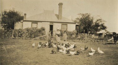
Photograph, Mair family visiting the Jarmans at Derrinallum, c1927 (2), c1927
David Miller (Dave) Mair (1879-1938) married Lily Vipond Deakin (1890-1945) in 1910. They had 5 children: Geoffrey David (1913-1970), Beryl (1916-1976), Gwynneth (1917-1997), Isabel Lillian (1921-1997) and Shirley Inez (1928-1968). Personal communication from Laurie Newton, Beryl's daughter: Dave and Beryl initially lived in East Melbourne after they married. Dave walked across the gardens to work at the MCG. He never drove or owned a car. Geoffrey, Beryl and Gwynneth were born in East Melbourne. They subsequently moved to Louise Avenue, Mont Albert and Isabel may have been born while they were there. Later they purchased 20 Barton Street, Mont Albert. Shirley was born after they moved to Barton Street. Electoral roll details: 1919 1922 24 Louise Avenue, Mont Albert 1924 20 Barton Street, Mont Albert Dave Mair was a very keen sportsman. This is part of a large donation of material from the Deakin, Mair and Young families. The Deakin, Mair and Young families had many connections with Mont Albert and Surrey Hills.A sepia photo of a woman and 2 girls standing behind about 30 fowls. The woman is holding a dish. In the background is an Edwardian (?) timber house with 2 brick chimneys and a corrugated iron roof, the ridge of which has a narrow peak with simple finials and ridge tiles. There is a centrally positioned (?) rear door with windows either side. There is a tank to the left of the house and a veranda to the RHS. The house is enclosed within a post and wire fence with a wire gate in line with the door. The fence appears to be lined with large rocks and behind the fence is garden plants of which cannot be identified. A few cows are to the right off-side.On the rear in black ink: "Feeding the fowls at / Derrinallum / Beryl Mair / 20 Barton Street / Surrey Hills / E10." Writing may be that of Lily Mair. In blue biro: " Gwen Beryl Mrs Jarman / Beauty (Jersey cow)" Thought to be Beryl Mair's handwriting. "KODAK PRINT" in black. beryl mair, gwen mair, farms, derrinallum, mrs jarman -
 Surrey Hills Historical Society Collection
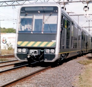
Photograph, Double deck (4D) train through Surrey Hills
These were introduced in 1992 on the Lilydale-Belgrave lines only (not on the Alamein or Waverley lines). They were a prototype. Many station platforms had to have the coping reduced or replaced in order to provide clearance. The trial was a failure because, while the carriages carried more passengers, they also took longer to load and unload, negating any benefits from carriage of extra passengers. They were used as off-peak trains only on the Surrey Hills line. The 4D carriages were based on the Tangara carriage being built by A Goninan & Co for CityRail in Sydney, however they were similar only in terms of interior and exterior bodywork. They were manufactured from stainless steel and were fitted with air-conditioning, tinted windows, and inter-car doors, allowing passengers to access all carriages of the train. A coloured photograph of a double decker train - silver in colour with a yellow and green strip across the front of the train.Double Decker train / through Surrey Hillssurrey hills, trains, tangarra carriage, a goninan & co, 4d train, belgrave lilydale lines -
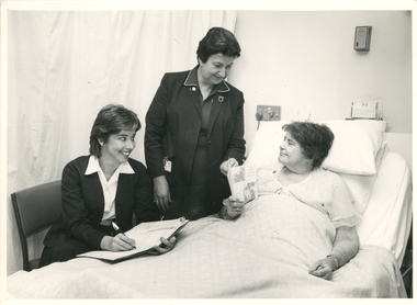 Royal District Nursing Service (now known as Bolton Clarke)
Photograph - Photograph, black and white, Barry Sutton, c.1970
This photograph shows Royal District Nursing Service (RDNS) Sister (Sr.) Moira Coates doing Liaison work at St. Vincent's Hospital in Melbourne. Miss C. Healy is St. Vincent's Home Care Supervisor and she and Sr. Coates are discussing plans with Miss E. Monks for the future care she requires following her discharge from hospital. Sr. Coates is wearing the RDNS uniform of a royal blue dress with white piping around the peaks of the collar. An RDNS logo is on its upper left. She is wearing a darker blue jacket.Liaison had occurred between Doctors and the the Trained nurses (Nurses) of the Melbourne District Nursing Society (MDNS), from its inception in 1885. This increased when Midwifery was introduced in August 1893 with close liaising with the Women’s Hospital. As District nursing grew it was recognized that closer liaising between many Public Hospitals would be beneficial, for not only the MDNS, later called Royal District Nursing Service (RDNS), Trained nurses (Sisters), but also for the patients and the hospitals. In August 1964 a Liaison Officer commenced at the Alfred Hospital. This soon increased to Liaison Officers working full time at several Public Hospitals. They facilitated the smooth transition from hospital to home for many patients who required ongoing nursing care. Liaison Sisters regularly attended discharge planning meetings, interviewed prospective patients, co-ordinated discharge and booked the first visit by the visiting RDNS Sister. At the time of a patient’s discharge, the Liaison Sister forwarded information on their diagnosis and instructions regarding the care required at home to the appropriate RDNS Centre, and in turn the attending District Sister wrote a report of progress and any queries to the Hospital Doctor, via the Liaison Sister, at the time the patient was attending outpatients. Any new instructions were then sent back to the District Sister. Liaising also occurred between District Sisters and Doctors when patients were referred by General Practitioners and did not attend a hospital.In the left foreground of this black and white photograph is Miss C. Healy who has collar length dark hair and is wearing a hospital uniform dark cardigan over a white blouse and dark skirt. She is sitting on a kitchen style chair and has an open folder; a pen in her right hand is poised over a white sheet of paper. She is smiling and looking to her left at Miss E. Monks who is resting in a bed in front of her. Standing to her right, and at the head of the bed, is RDNS Sister Moira Coates who has short dark hair. and is wearing a dark jacket over a dark colour dress with white piping on the collar peaks. Her identity card is clipped on the right hand pocket. She is smiling at Miss Monks and has her left hand on an RDNS leaflet which Miss Monks is holding. To her right is Miss Monk who has short dark hair and wearing a light coloured nightdress. She sitting up supported against pillows on a hospital bed which has the top section raised. She is looking at the RDNS folded leaflet; two photographs and writing can be seen on the front cover. White bedclothes cover most of Miss Monks body. Drawn curtains are seen in the left rear of the photograph and some switches and a name card are seen behind the bed. Barry Sutton. LJ93 and namesrdns, royal district nursing service, rdns liaison, rdns uniform, sister moira coates, miss c. healy, miss e. monks -
Clunes Museum
Photograph - PHOTOGRAPHS
23 X COLOURED PHOTOGRAPHS OF THE 2010 FLOODING OF CRESWICK CREEK IN CLUNES .1QUEENS PARK .2 BLACKMORE ROAD .3 BOWLING GREEN .4 LIGAR STREET .5 QUEENS PARK .6 TOWARDS BOWLING GREEN .7 QUEENS PARK .8 BOWLING GREEN .9 SENIOR CITIZENS .10 THE OVAL .11 33 ANGUS STREET .12 WATER CURRENTS .13 LOOKING TOWARDS FORMER TONY BAILEY'S HOUSE .14 ANGUS STREET .15 LOWER FRASER STREET .16 CORNER CAMERON STREETS - FLOOD PEAK AT 5PM .17 AT GOVERNMENT BRIDGE .18 LOOKING DOWN CAMP HILL .19 FORD .20 BUTTER FACTORY BRIDGE .21 BESIDE BOWLING GREEN .22 BUTTER FACTORY BRIDGE .23 DAMAGE AT FORD clunes floods 2010, creswick creek flood -
 Eltham District Historical Society Inc
Photograph - Digital Photograph, Alan King, Wellers Restaurant, 150 Eltham-Yarra Glen Road, Kangaroo Ground, 23 January 2008
Originally Wellers Hotel, it was constructed by Edward Weller in 1872. Following his death in 1883 it was taken over by his widow, Mary Weller. The hotel was delicensed in 1909 and converted to a private residence. Around 1920 William Pitman bought the property, succeeded by his son Vernon who coined the term Pittman's Corner. Vernon and Isabel Pitman owned the house form 1945-1973. Following Vernon's death, Isabel remained there till her death in 1983. The property was converted to a restaurant in 1984 by owners Robert and Kath Hendry who undertook extensive renovations in 1988. Shawn and Stephanie Wolfe purchased the property from the Hendrys in 2003 and introduced live entertainment with many famous bands and entertainers from the 1960s, 1970s and 1980s performing there, including James Reyne, Daryl Barithwaite, Brian Cadd and Billy Thorpe. In 2014 the Wolfe's sold the property and the entire contents were sold at auction. New (local ) owners Gregory Anderson, Craig Jones and Steve Gist refurbished the property and relaunched it as Fondata 1872 in 2017. Covered under Heritage Overlay, Nillumbik Planning Scheme. Published: Nillumbik Now and Then / Marguerite Marshall 2008; photographs Alan King with Marguerite Marshall.; p87 A low-lying brick building at a turn on the main road, on the way to Kangaroo Ground, was once a welcome resting place for travellers. In the late 19th century Weller’s Pub, as it was called then, provided a store and an overnight stopping place and changing post for Cobb & Co coaches. The coaches were bound for the Caledonia Goldfields, near Queenstown (now St Andrews) and the Woods Point gold mines.1 Builder Edward Weller constructed the hotel and store on three acres (1.2 ha) in 1872 and after he died in 1883, his widow, Mary, continued to run the hotel, which was delicensed in 1909. This was not the first enterprise Weller ran in the district. In about 1866, he came to Kangaroo Ground and rented a general store and nine acres (3.6 ha) of land. The store, opposite the present school, was on the site of the present store and Weller also acted as the postmaster there. Mrs Weller was born in Scotland in 1841 and came to Victoria with her parents in about 1852. After two years in Melbourne the family moved to the Caledonia Goldfields where they remained for several years during which time she married Weller. The couple subsequently had five sons and five daughters. Weller’s Pub was made of handmade bricks fired from clay dug on the property. The pub must have been a haven on hot days with its 40cm thick walls throughout. One quaint reminder of its early use is that every room except the dining room has an outside door. Inside, the pub was converted to a home with extra doors connecting the inside rooms. There is no trace of the original bar room in the present dining room, where the steps leading to the cellar were bricked in. An unusual feature is the pressed metal which lines the ceilings, yet with moulding and white paint, looks like plaster. The main road once passed the back of the building and wound up to the top of the hill through a cutting. This steep hill was known to the bullock drivers in the early days, as Salvation Hill, because they were always very glad to reach its peak. After the hotel was delicensed it was converted to a private residence and extensive renovations were made, changing much of its design from a Victorian to an Edwardian style.2 Between 1912 and 1915, Gordon Cameron, a Cobb & Co coach driver and his wife rented the former hotel. Mr Cameron was related to the parliamentarian Ewen Cameron of Pigeon Bank, Kangaroo Ground, and his wife was related to Albert Pepper who owned Pigeon Bank from 1916 to 1919, when Gordon Cameron bought it. About 1920 William Pitman bought the property, which in turn was owned by his son, Vernon, who coined the name Pitman’s Corner. He and his wife Isabel owned the house from 1945 to 1973. Then as a widow Isabel Pitman lived there until her death in 1983.3 In 1984 the property was converted to a restaurant by owners P A Tribe, a barrister, his wife Sharon, and Robert and Kath Hendry. Extensive renovations maximised the splendid views of the Dandenong Ranges and the Yarra Valley.This collection of almost 130 photos about places and people within the Shire of Nillumbik, an urban and rural municipality in Melbourne's north, contributes to an understanding of the history of the Shire. Published in 2008 immediately prior to the Black Saturday bushfires of February 7, 2009, it documents sites that were impacted, and in some cases destroyed by the fires. It includes photographs taken especially for the publication, creating a unique time capsule representing the Shire in the early 21st century. It remains the most recent comprehenesive publication devoted to the Shire's history connecting local residents to the past. nillumbik now and then (marshall-king) collection, eltham-yarra glen road, fondata 1872, kangaroo ground, wellers restaurant, billy thorpe, brian cadd, craig jones, daryl barithwaite, edward weller, gregory anderson, hotels, james reyne, kath hendry, mary weller, restaurants, robert hendry, shawn wolfe, stephanie wolfe, steve gist -
 Bendigo Historical Society Inc.
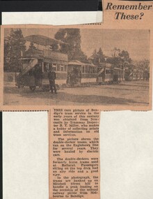
Document - BASIL MILLER COLLECTION: REMEMBER THESE, c1970s?
... Street hill to handle a peak loading on the occasion... on Mitchell Street hill to handle a peak loading on the occasion ...Newspaper article. Remember These? Includes a rare picture of Bendigo's tram service in the early years of this century (20th) . B T Miller's hobby is collecting prints and information on old tram services. Picture includes Double Decker Tram, hauled by electric cars. Double Deckers were formally used in Ballarat with horses. In the photograph the trams are banked up on Mitchell Street hill to handle a peak loading on the occasion of the annual railway picnic from Melbourne to Bendigo. Article possibly post 1972.cottage, miners