Showing 74 items matching "railway crescent"
-
 Glen Eira Historical Society
Book - CAULFIELD CENTENARY 1957
This file contains four items 1/Two copies of a twenty-four page booklet titled CITY OF CAULFIELD CENTENARY 1857-1957, created by the Caulfield City Council and printed by Peter Isaacson Pty Limited, Melbourne. The booklet details important aspects of Caulfield’s history including council procedures, the Caulfield Road District Proclamation, the first election and a summary of 100 years of local government with a description of the present Caulfield in 1957. The booklet also includes several pictures of various Caulfield landmarks and people including one of Caulfield City Councillors (11 men and 1 woman). Also one photocopied version of this booklet. 2/Eleven pages of typed notes for the City of Caulfield Centenary booklet. All notes are undated and incomplete. Two pages titled NOTES on THE HISTORY and PROGRESS OF THE CITY OF CAULFIELD, author unknown. Three and a half pages titled THE STRUCTURE OF LOCAL GOVERNMENT IN VICTORIA, author unknown. Five pages titled 100 YEARS OF LOCAL GOVERNMENT – EARLY CAULFIELD, by Mrs A. P. Bell. 3/A typed letter to Miss V. Webb-Langdon from the Town Clerk H.G. Nelson, acknowledging her contribution to historical details for the Caulfield Council’s Centenary booklet, dated 24/12/1957. 4/A handwritten letter and a handwritten note regarding the acquisition of notes for the Caulfield Centenary booklet. The letter is dated 03/08/2006 and the note is dated 09/02/2007.city of caulfield centenary, caulfield road district, sinclair a.j.g., city hall, war memorials, gamble h.a., machin l.r., bunny f.c.d., caulfield park, koornang reserve, parton e.m., sims h.e., thomson w.r., gunn e.e., yorston j.s., wallace g.e. mrs, green w.c., jenner e.r., ward boundaries, dandenong road, queens avenue, normanby road, station street, bond street, glen eira road, orrong road, poath road, north road, booran road, nepean highway, glen huntly road, glenhuntly road, inkerman road, hotham street, nelson h.g., fullard w.r., mackley g.j., ellis k.i, crosbie m.r., nutting b.i., body j.h., pritchard r.j., guildford l.t.g., lund l.m., street h.c., reynolds a.w., elections , political processes, local government, springthorpe reserve, greenmeadows gardens, business and finance, roads and streets, caulfield racecourse, east caulfield reserve, mackinnon reserve, hawthorn road, balaclava road, murrumbeena road, lempriere avenue, victoria street, koornang road, lord reserve, lyons street, murrumbeena reserve, kangaroo road, ormond park, beatty crescent, foch street, packer reserve, oakleigh road, leila road, prices park, bambra road, riley reserve, playgrounds, town hall, maternal and child health centres, truganini road, grange road, senior citizens centre, barkley sir henry, moore david, handasyde gilbert, caulfield school room, harris g.w., semple john, dempsey william, brooks w.a., wilson thomas, lyall william, murrum murrumbeen lifestyle, ‘greenmeadows’ house, lempriere family, aboriginal culture, ‘rippon lea’ house, caulfield john, ‘slaney’s’ home, alma road, paddy’s swamp, racecourse hotel, caulfield technical college, bevan mr., ‘grosmont’, hart john, railways, mansions, ‘rosecraddock’, langdon h. j., caulfield cup, ‘crotonhurst’, webb judge, ‘kilwinning’, service james, ricketson henry, ‘glen eira’, house names, garden vale, ross william murray, ‘ross’s folly’, outer circle railway, caulfield grammar school, davies j. henry, lagdon william, grimwade f.s., loyd charles du plan, hope george, ‘airdrie’, kooyong hill, market gardens, dairies, lady talbot milk supply, jenner family, o’niell college, presentation sisters, glenferrie road, grimwade frederick sheppard, grimwade alice, ‘harlston’, grimwade house, ‘saint aubin’s’, ‘st. aubin’s’, ‘caulfield hall’, caulfield john p.t., st georges road, caulfield military hospital, nursing homes, health establishments, dover street, sports and recreations, rosanna street, ‘cantala’, health services, parks and reserves, community services, town planning, local government finance, local officials and employees -
Glen Eira Historical Society
Document - GLEN HUNTLY
This file contains 3 items about land subdivision and development in Glen Huntly: 1/1 colour real estate advertisement (undated) for the auction of lots of land in Glen Huntly Park Estate, Glen Huntly to be held 06/12/1930. The poster includes1 black and white photograph (85mm x 201mm) of the Shopping Centre on Glen Huntly Road and a colour map (95mm x 107mm) of the Estate and surrounding locality. Also included on the poster is 1 black and white photograph of the Glen Huntly Park Estate and Cypress Plantation of the Glen Huntly Park. 2/1 undated advertisement for an auction of land in Glen Huntly Park to be held 19/03/1938 pursuant to an order to an order for sale made by the Supreme Court of Victoria. It includes 1 black and white photograph (52mm x 375mm) of shops along Koornang Road and 1 black and white photograph (52mm x 375mm) of shops along Glen Huntly Road. 3/1 black and white aerial photograph (undated and unattributed) (164mm x 272mm) of Glen Huntly Park Estate and surrounding area, with street names added, which indicates the second section of the Estate for sale.glen huntly, grange road, glen huntly road, watson crescent, garden avenue, wattle avenue, park avenue, mckay avenue, neville street, miller street, morgan street, truganini road, koornang road, glen huntly park and recreation reserve, glen huntly park estate, royal avenue, glen huntly railway station, tram depots, lyons street, moira avenue, katandra road, ormond, mimosa road, glen huntly park pty ltd, city of caulfield, lord h, land sales, auctions, parks and reserves, shops, elsternwick, caulfield -
Glen Eira Historical Society
Document - GLEN HUNTLY (HISTORY OF)
... Carlisle Crescent Railways Trains Parks and Reserves Caulfield ...This file contains one item: 1/A loose-leaf, 23-page document titled ‘The History of Glen Huntly’, by Alfred R. Jones, dated 20/06/1991, describing the history of the suburb. The author has drawn heavily from the 4 sources noted in the bibliography. Subjects covered include the ship the suburb is named after, the suburb’s State School, the suburb’s churches, the Rosstown Railway and Sugar Mill, the origin of the name of Carnegie, the suburb’s aerodrome, and the beautification of the Glen Huntly Shopping Centre. The final 12 pages consist of 9 appendices relating to the aforementioned subjects. Appendix A is a typewritten letter from Ron McLeod, secretary of the Place Names Committee, to Mr. D. R. Aylen, CEO of the City of Caulfield, notifying the latter of the alteration of the name ‘Glenhuntly’ to ‘Glen Huntly’. Appendix B is a list of the ministers of St. David’s Uniting Church from its formation in 1916 to the present. Appendix C identifies the persons portrayed in St. David’s stained glass windows. Appendix D is a poster announcing the auction of 41 blocks of land between Hawthorn and Bambra Road formerly owned by William Ross, plus a map identifying said land blocks and anither fir locality. Appendix E is an A4 plan of the Rosstown Railway. Appendix F is a drawing of the Rosstown Sugar Mill. Appendix G is a poem titled ‘The Swagman’s Retreat’, by Herb Arnott, about the failure of the Mill. Appendix H is a map of Caulfield’s horse tramways plus a list of opening and closing dates. Appendix J is a list of streets explaining the meanings of their names.glen huntly, glenhuntly, local history, ‘glen huntly’ (ship), ‘glen huntlely’ (ship), quarantine stations, glen huntly road, lake street, mernda avenue, glen huntly state school no. 3703, ormond francis, ormond, garden avenue, grange road, churches, congregational church, glen huntly presbyterian church, st. david’s, st. david’s uniting church, anglican church, jenkin william ‘boss’, methodist church, wattle avenue, smith a. w. mr., glen huntly post office, glen huntly road, king f. l. mr., uniting church, child care centre, presbyterian church of eastern australia, glen huntly methodist church, sun aria, miller mary, stained glass, phrenologists, trinity congregational church, primitive methodists, ‘the victorian independent’, mercy mr., greek orthodox original old calendar church, wanalta road, salvation army, halls, myrtle street, catholic church, st. anthony’s roman catholic church, foundation stones, neerim road, mannix archbishop, st. agnes’ anglican church, booran road, sunday schools, clergy residences, ‘see’ anglican news magazine, lees archbishop, booth archbishop, glen huntly presbyterian church, el nido grove, tennis courts, bollard v. w. right rev., waratah avenue, royal avenue, munster avenue, james street, rothschild street, peace memorial organ, singers, bremner marie, scotland betty, carden joan, rosstown railway, south caulfield, plants, marata road, curraweena road, bambra road, ross william murray, ross leila, ross constance, vautin constance, ‘the grange’, north road, leila road, wild cherry road, caulfield roads board, elsternwick, land sales, sugar mills, koornang road, woornack road, elsternwick railway station, riddell parade, clarence street, dover street, oakleigh road, murrumbeena crescent, carlisle crescent, railways, trains, parks and reserves, caulfield council, sussex street, caulfield city council, swamps, rosstown sugar mill, rosstown estate, ‘the swagman’s retreat’, arnott herb, rosstown, carnegie, ‘ross’s folly’, carnegie andrew, rosstown hotel, dandenong road, rosstown road, rosstown plate horse race, caulfield racecourses, ames avenue, rosstown court, hostels, murrumbeena, cinemas, innovations (cabinetry film), films, music, pianos, manchester grove, safeway store, squash courts, airports, lord reserve, aeroplanes, air navigation act 1921, neville street, larkin sopwith aviation company of australasia, lyons street, morgan street, bookmakers, nightsoil, poultry, weatherboard buildings, glen huntly railway station, rosedale avenue, rifle clubs, scout groups, 1st glen huntly troop, ana, dowding jack mr., glen huntly infant welfare and family planning clinic, vermador private hospital, watson grove, rowlands (drapers), bones plant nursery, caulfield railway station, bridges, trams, horse tramways, glen eira road, elsternwick railway station, kooyong road, aboriginal peoples, truganini road, hannan lyn mrs. (urban planning officer), glen huntly shopping centre, sculptures, street beautification scheme, “flying the yellow flag”, moore olive, “return to rosstown”, jowett d. f., weickhardt i. s., “from sand swamp and health”, murray peter r., wells john c., caulfield historical society, newsletters, place names committee, mcleod ron, aylen d. r. mr., jones hugh rev., king joseph, scarfe james, vertigan sidney, vertigan earle, rance victor, flavell cameron, denholm robin, moorhead ken, taliai siupeli, eccles james leslie, little agnes, hutchins william r., dickie may a., gordon ivey agnes, theobald a. a. mrs., brownbill lloyd norman, ash georgette, land sales, auctions, messrs. crews & arkle, street names -
Glen Eira Historical Society
Document - National Trust Register
This file contains two items relating to historic buildings in Glen Eira listed on the National Trust Registry: 1/A fax, sent to Gladys Vallati on 02/03/1995 from the National Trust of Australia listing buildings on the Trust’s registry in the Glen Eira area, as well as their addresses and status on the register (5 pages). (Additional photocopy taken for preservation purposes). 2/A typed list of buildings in the Glen Eira area (mainly Caulfield) which are on the National Trust list, including address, approximate date of construction and status on the register. Date of production of the list is unknown. (6 pages).neerim road, poplar grove, avoca grove, balaclava road, orrong road, bambra road, glen eira road, hood crescent, hawthorn road, glenferri street, glenhuntly road, glen huntly road, kambrook road, kooyong road, lirrewa grove, manor grove, north road, pearson avenue, seymour road, alma road, craddock avenue, dandenong road, lyndoch avenue, orrong crescent, hotham street, nagle avenue, inkerman street, iknerman road, sandham street, selwyn street, st. georges road, willow street, grange road, station place, railway parade, alexandra street, wood crescent, elizabeth street, halstead street, mavho street, tucker road, mckinnon road, nepean highway, wheatly road, uniting church carnegie, athole, st stephen's uniting church caulfield, st aloysius' catholic church, halstead, st mary's anglican church caulfield, caulfield town hall, anseln, the glen, woolamai, caulfield house, caulfield hospital, lirrewa, labassa, fairfield hall, bellecourt, bagatelle, myoora, rosecraddock, adam and eve - karl duldig, the family - karl duldig, caulfield primary school, septimus miller memorial chapel, brighton cemetery, hopetoun gardens, state savings bank elsternwick, anderson organ, hopetoun private hospital (melrose), rippon lea, ripponlea, burreel, o'neill college, lisbon house, elsternwick club, merkin-schutze organ, presentation convent, duldig mural - kadimah cultural centre, glenmoore, craigellachie, st james the great, glenfern, grimwade house, dacre, trinity congregational uniting church glenhuntly, alnwick, holmwood, new alexandra, joscelyne organ, smith organ, fincham organ, st george's bentleigh, mckinnon progress hall, wurlitzer organ, moorabbin town hall, christ anglican church, st mary's jubilee school, st stephen's presbyterian church, elsternwick congregational church, st mary's church of england, former metropolitan fire brigade station no. 31, st mary's jubilee church, belle court, trinity congregational church, heatherbrae, carnegie, caulfield, caulfield north, caulfield south, elsternwick, glen huntly, glenhuntly, murrumbeena, st kilda east, bentleigh, mckinnon, moorabbin, ormond, national trust of australia, national trust register, houses, churches, schools, organs, vallati gladys, mansions -
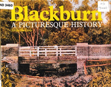 Whitehorse Historical Society Inc.
Book - Chronicle, Blackburn, A Picturesque History, 1978
... Post Office Blue Moon Fruit Co-operative Ltd Blackburn Railway ...A chronicle of Blackburn with photographs, diagrams and maps from the 1850's onwards.A chronicle of Blackburn with photographs, diagrams and maps from the 1850's onwards.non-fictionA chronicle of Blackburn with photographs, diagrams and maps from the 1850's onwards.open air school blackburn no3850, blackburn., morton park, traveller's rest hotel, blackburn lake sanctuary, blackburn creek hotel, blackburn road blackburn, blackburn post office, blue moon fruit co-operative ltd, blackburn railway station, pioneers, gordon crescent blackburn, lake road blackburn, goodwin george augustus, morton thomas richards burrowes, st johns anglican church blackburn, blackburn methodist church, blackburn church of christ, blackburn primary school no 2923, blackburn scout group 1st, blackburn and district tree preservation society, g.f. fankhauser -
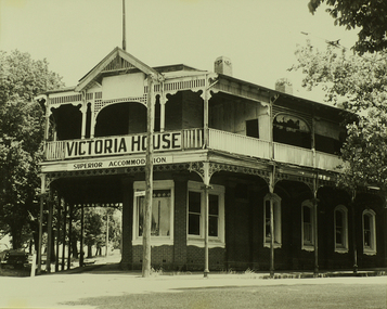 City of Ballarat Libraries
Photograph, Victoria House, Lydiard Street North, Ballarat
... and Doveton Crescent, diagonally opposite the railway station. ... and Doveton Crescent, diagonally opposite the railway station ...An image from the Herbert Richmond collection, gifted in 1982 to the Ballarat Library. The collection contains approximately 200 photographs of Ballarat and district in the 1940s, 50s and 60s, as well as photo albums, glass negatives and other memorabilia. Herb Richmond was a keen photographer, a foundation member and a life member of the Ballarat Camera Club, and a photographer with the Ballarat Courier during the 1940s. The Ballarat Camera Club named an annual award after him. Mr Richmond died in 1981 aged 79. These images were digitally re-photographed by members of the Ballarat Camera Club in September 2006. This building once stood on the angled corner of Lydiard Street North and Doveton Crescent, diagonally opposite the railway station. victoria house, lydiard street north -
 Kew Historical Society Inc
Photograph - Filling in the Outer Circle Railway cutting at East Kew, 1939
W.D. Vaughan (Kew's Civic Century, 1960, pp.195-6) quotes Council Minutes of 1938 and 1939 to record that: "After protracted negotiations between the Council, the Railways Department and the Tramways Board agreement was reached in June, 1938, for the filling of the railway cutting at the Harp Junction and shifting tram tracks to the High Street alignment ... The Outer Circle railway land from Princess Street to Park Crescent was purchased by the Kew Council in October, 1939, for 2,750 [pounds]. The land from Park Crescent to High Street was leased for 1 [pound] per annum. Considerable work was done in levelling the embankments to the original surface level."Important and rare photograph of the period, showing major works by Kew Council in Kew East working on a significant piece of urban infrastructure.Small, original black and white positive (photograph) showing workers and vehicles filling in the tracks of the former Outer Circle railway at East Kew. In the background is the metal bridge with brick piers, adjacent to the Harp Junction. The bridge crossed the cutting, linking the two parts of High Street. Behind the tip truck, painted on the side with the name 'Fowler Quarries' [located Keilor Road, North Essendon], one can see shops [including T.G. Garroway, Cash Grocer] in High Street. What appears to be the City of Kew Steamroller is immediately in front of the bridge. A group of passers-by watch from the bridge and from the road. Annotation in pencil on verso: "Filling in Outer Circle line at High St East Kew prior to straightening High St. (c. Feb 1930?)outer circle railway, railway cuttings, harp junction, high street -- kew east -
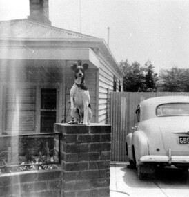 Surrey Hills Historical Society Collection
Photograph, 55 Sunbury Crescent, Surrey Hills - Home of Fred Lyons and his family
This was the home of Fred Lyons and family from c1920. Previously they had lived in Lorne Parade. Fred had a hansom cab at the rank at the Surrey Hills station from c1919 and stabled his horse in a paddock to the rear of this house. His son Arthur Lyons remained living here until 1990. The fox terrier was Fred's constant companion. This is one of a series of photos donated by Arthur Lyons. From 1907 a cab service operated from near the railway gates in Union Road. It was established and maintained by Mr C Fraser until c1916. George Rea either took over then or set up in opposition. Fred Lyons initially worked for George until he set up his own business. In time he changed over to a motor vehicle and continued his service until 1960. Frederick Adolphus Lyons (1891-1980) was born in Surrey Hills, son of Thomas and Catherine Lyons. He married Elizabeth Ruby Hall in 1918. They lived in Lorne Parade before moving to 55 Sunbury Crescent. The Lyons’ home in Sunbury Crescent was called ‘Knopshambury’ - this was probably a misspelling of Knockshanbally in Co Kilkenny, the birth place of Fred’s father, Thomas Edmund Josias Lyons (1846-1915). Arthur Lyons was born in Surrey Hills on 12 Jun 1920. He became a motor mechanic / welder and lived his whole life at 55 Sunbury Crescent. The donation was made while he was in hospital. He died shortly afterwards (23 Sep 1990). Donation was finalised by a neighbour, Mrs Florence Ann Armitstead, wife of Glen Victor Armitstead. Glen was a local hairdresser. They moved to 11 Sunbury Crescent after their marriage in 1939. Arthur had no relatives to distribute the material to.Black and white photo of the home of Fred Lyons and his family. It is a simple timber cottage with a corrugated iron roof and a low brick fence with wrought iron decorative infill between the brick pillars. A fox terrier sits on the brick pillar next to the driveway. On the RHS of the house a high slatted timber fence divides the front from the rear of the property. An early model Holden is parked in the driveway, the number plate beginning with GBEOn the back in pencil "copied 1996" . In black pen "Lyons, Sunbury Cres" timber cottages, arthur lyons, arthur frederick lyons, fred lyons, frederick adolphus lyons, elizabeth ruby hall (miss), elizabeth ruby lyons (mrs) -
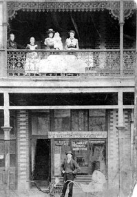 Surrey Hills Historical Society Collection
Photograph, Fred Ambler and Family
... , on the corner of Sunbury Crescent, opposite the Railway Station. Photo..., builder, at 122 Union Road, on the corner of Sunbury Crescent ...Fred Ambler and family at Albert Mills Premier Land Agency building on the corner of Union and Sunbury Roads, c.1910. Fred had his carpenter and upholstery business on the ground level and his home above. (No.1) Premier Land Agency Building, was built in 1886-7 by Albert Mills, builder, at 122 Union Road, on the corner of Sunbury Crescent, opposite the Railway Station. Photo shows his wife and family. Alfred died in 1890 and the family moved. The Boroondara Standard in 1888 reported: "Splendid block of brick buildings reaching completion in Union Road adjacent to railway line – 2 storey. Frontage 120 feet for Premier Land Agency. Shops at Ground Level." A sepia coloured photograph of a two storey terrace building with 3 ladies and 2 children standing on the balcony. Downstairs, a gentleman stands outside the shopfront beside two prams. There is a child in one pram.albert mills premier land agency building, (mr) fred ambler, union road, carpenter, upholsterer, sunbury crescent -
 Surrey Hills Historical Society Collection
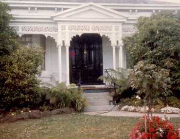
Photograph, 101 Guildford Road, Surrey Hills
The house was built in 1883, possibly to encourage development of housing on the first urban land subdivision in Surrey Hills, the Windsor Park Estate (in the Windsor Crescent area). This coincided with the opening of the Surrey Hills Railway station. The first occupant was John Brown Nicholson, police magistrate. In 1884 the foundation meeting of the Wyclif Congregational Church was held in the house.Colour photo of the front door and verandah of 101 Guildford Road taken from the street. The house is Victorian in style with ornate lacework along the verandah. It is painted white and has a slate roof. There is a well-maintained garden with flower beds and shrubs, which partially obscure the house.victorian style, wyclif church, houses, guildford road, john brown nicholson -
 Surrey Hills Historical Society Collection
Photograph, Surrey Hills looking south-east from the steeple of Holy Trinity Church, 1921, 1921
The property in the foreground is 'Edgeware' at 171 Union Road, a house built by the Zeplin family. It became the home / residence of Dr Percy Liddle and later Dr James Landells Blakie. By the time this photo was taken Dr Blakie had moved across the road to 174 Union Road. In the background behind the 2 houses in the foreground is the Surrey Hills Stationmaster's house, sitting behind a picket fence. The Alan Holt register gives a build date of c1915 for this house, which fits stylistically. The first stationmaster was probably Michael Ginnane, who stayed in the area after he retired, moving to 1 Russell Street. This property was listed as 8 Bedford Avenue, the only house on the south side of the road. It was demolished in c1972 to make way for widening of the rail track with a third line. The photographer Norman Carter took many photos of Surrey Hills and Mont Albert from the 1920s, in particular of events and activities associated with the Church of England.Black and white photo taken from the steeple of Holy Trinity Church looking across housing towards the railway line and Albany / Windsor Crescents and on towards Canterbury Road. Surrey Hills Primary School and St Stephens Presbyterian Church feature prominently on the horizon. The stationmaster's cottage is centre left adjacent to a large conifer-like tree, with a white fence delineating the railway yards.On back of original: "6-11-21" and in a different hand in biro: "from tower of Holy Trinity Church"albany crescent, windsor crescent, st stephens presbyterian church, surrey hills primary school, railways, stationmasters' houses, bedford avenue, norman carter, edgeware, dr percy liddle, dr james blakie -
 Surrey Hills Historical Society Collection
Photograph, Stirling Crescent, Surrey Hills in 1930s, 1930s
Paddy Slavin had a bakery at 118 Union Road, which had a rear exit onto Stirling Crescent. On the left is part of Paddy Slavin’s Bakery at 118 Union Road. The house with the hedge was that of Ada McBeath, organist for many years at the St Stephens Presbyterian and the Wyclif Churches, who lived at No.16 from 1900-1943. Phillip and Winifred Slavin are still listed in electoral roll in 1963 but by 1968 had moved to Gipps Street Collingwood, where he was still employed as a pastrycook. A black and white photograph of a street with some houses and cars on the left and electricity poles and the railway line on the right hand side.stirling crescent, surrey hills, bakery, streetscape, (ms) ada mcbeath, churches, organist, (mr) phillip slavin, (mrs) winifred slavin, streetscape, pastrycook, wyclif congregational church, (mr) paddy slavin, st stephens presbyterian church -
 Surrey Hills Historical Society Collection
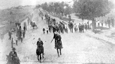
Photograph, Parade in celebration of King Edward VII's birthday, 1902, 1902
The parade was held in celebration of King Edward VII's birthday on 4 July 1902. This was the first public appearance of the German Band formed on 30 May 1902. The leading horseman is Mr Rowland Coe. He is followed by Mr George Robinson, a butcher of Canterbury Road. The man in the white hat is Mr Sam Kellett, businessman of Erasmus Street. Behind him on foot and partly obscured is Mr Alexander McNeill of the Surrey Family Hotel. Band master is Harry Pollard, painter and paper-hanger, and next to him is Constable Hill. The small boy in the sailor suit is Perc Venman of Essex Road and in the buggy near the footpath is Mr and Mrs William Maling. Information came from David Staig senior. Further research: William Saunders Maling, a son of John Butler Maling, was a builder who lived at 17 Balwyn Road, Canterbury. Rowland Coe, a butcher and son of James and Elizabeth Coe of Sunbury Crescent enlisted in AIF in WW1. He later lived at 233 Elgar Road, Box Hill. William Percival Reginald (Perc) Venman was born in Surrey Hills in 1894; he died in Surrey Hills in 1951 and lived at 27 Essex Street for much of his life. He and his wife are buried in Box Hill Cemetery. The identity of Sam Kellett of Erasmus Street is questioned. Edward Kellett built 'Yielma' in Erasmus Street but was deceased by 1902. He had 3 sons: Edward Allan (1854-1932); George Henry (1858-1921) and William John (1865-1945).Black and white photo of a number of men on horses leading a parade down Station Street (Windsor Crescent) to Union Road. Street trees on the RHS are mature whilst the ones on the LHS look to be newly planted. They have wooden guards around them. The area to the left is blurry but would be the railway line and station surrounds. Roads are well formed with bluestone channels.parades and processions, bands, german band, windsor crescent, william saunders maling, mrs hannah maling, miss hannah miller, constable hill, perc venman, george robinson, sam kellett, alexander mcneill, rowland coe, harry pollard, william percival reginald venman -
 Surrey Hills Historical Society Collection
Photograph, Fred Lyons' cab
This is one of a series of photos donated by Fred Lyons. From 1907 a cab service operated from near the railway gates in Union Road. It was established and maintained by Mr C Fraser until c1916. George Rea either took over then or set up in opposition. Fred Lyons initially worked for George until he set up his own business. In time he changed over to a motor vehicle and continued his service until 1960. Frederick Adolphus Lyons (1891-1980) was born in Surrey Hills, son of Thomas and Catherine Lyons. He married Elizabeth Ruby Hall in 1918. They lived just around the corner at 55 Sunbury Crescent. The Lyons’ home in Sunbury Crescent was called ‘Knopshambury’ - this was probably a misspelling of Knockshanbally in Co Kilkenny, the birth place of Fred’s father, Thomas Edmund Josias Lyons (1846-1915). Arthur Lyons was born in Surrey Hills on 12 Jun 1920. He became a motor mechanic / welder and lived at 55 Sunbury Crescent. This is one in a series from the Lyons' photo collection. This was gifted to the SHNCHC by Arthur Frederick Lyons, son of Frederick Alphonsus (Fred) Lyons and Elizabeth Ruby Hall, who married in 1918. Fred Lyons died 4/10/1980. The Lyons’ home in Sunbury Crecent was called ‘Knopshambury’ - this was probably a misspelling of Knockshanbally in Co Kilkenny, the birth place of Fred’s father, Thomas Edmund Josias Lyons (1846-1915). Arthur was born in Surrey Hills on 12 Jun 1920. He became a motor mechanic / welder and lived at 55 Sunbury Crescent. The donation was made while he was in hospital. He died shortly afterwards (23 Sep 1990). Donation was finalised by a neighbour, Mrs Florence Ann Armitstead, wife of Glen Victor Armitstead. Glen was a local hairdresser. They moved to 11 Sunbury Crescent after their marriage in 1939. Arthur had no relatives to distribute the material to. Perhaps this is the Buick Tourer mentioned on his business card.Black and white photo of Fred Lyons in one of his cabs. He is dressed in a white jacket. Behind the cab is a picket fence and part of a Victorian cottage. transport, businesses, fred lyons, frederick adolphus lyons, taxis -
 Surrey Hills Historical Society Collection
Photograph, Fred Lyons' hansom cab, c1916, 1916
This is one of a series of photos donated by Arthur Lyons. From 1907 a cab service operated from near the railway gates in Union Road. It was established and maintained by Mr C Fraser until c1916. George Rea either took over then or set up in opposition; he retired in 1945. Fred Lyons initially worked for George until he set up his own business. In time he changed over to a motor vehicle and continued his service until 1960. Frederick Adolphus Lyons (1891-1980) was born in Surrey Hills, son of Thomas and Catherine Lyons. He married Elizabeth Ruby Hall in 1918. They lived just around the corner at 55 Sunbury Crescent. The Lyons’ home in Sunbury Crescent was called ‘Knopshambury’ - this was probably a misspelling of Knockshanbally in Co Kilkenny, the birth place of Fred’s father, Thomas Edmund Josias Lyons (1846-1915). Arthur Lyons was born in Surrey Hills on 12 Jun 1920. He became a motor mechanic / welder and lived at 55 Sunbury Crescent. W T Nisbe... is probably William Thomson Nisbet, traveller of 'Maroona', Brenbeal Street, Balwyn listed in 1903, 1914, 1919 electoral rolls. His wife was Mary Grace Nisbet, son was William Thomson Nisbet Jnr (clerk) and daughter was Olive Thomson Nisbet (dressmaker). The donation was made while he was in hospital. He died shortly afterwards (23 Sep 1990). Donation was finalised by a neighbour, Mrs Florence Ann Armitstead, wife of Glen Victor Armitstead. Glen was a local hairdresser. They moved to 11 Sunbury Crescent after their marriage in 1939. Arthur had no relatives to distribute the material to.Black and white photo of Fred Lyons in one of his hansom cabs with his horse 'Barney' taken near Surrey Hills railway station. Another hansom cab is to the right of the photo and there is another man standing on the footpath. In the background are shops and the partial hoarding of W T Nisbe... is visible. The photo was taken between 1916-1927. On rear of the duplicate print in pencil in Jocelyn Hall's handwriting : "NO 59 / and 89 / Spare ? / perhaps better than enlargement"transport, horse drawn vehicles, businesses, fred lyons, frederick adolphus lyons, william thomas nisbet -
 Surrey Hills Historical Society Collection
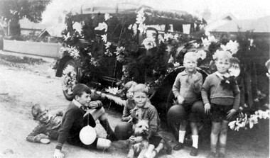
Photograph, Fred Lyons taxi decorated for Empire Day, 1930s
Lyons family history: From 1907 a cab service operated from near the railway gates in Union Road. It was established and maintained by Mr C Fraser until c1916. George Rea either took over then or set up in opposition. Fred Lyons initially worked for George until he set up his own business. In time he changed over to a motor vehicle and continued his service until 1960. Frederick Adolphus Lyons (1891-1980) was born in Surrey Hills, son of Thomas and Catherine Lyons. He married Elizabeth Ruby Hall in 1918. They lived just around the corner at 55 Sunbury Crescent. The Lyons’ home in Sunbury Crescent was called ‘Knopshambury’ - this was probably a misspelling of Knockshanbally in Co Kilkenny, the birth place of Fred’s father, Thomas Edmund Josias Lyons (1846-1915). Arthur Lyons was born in Surrey Hills on 12 Jun 1920. He became a motor mechanic / welder and lived at 55 Sunbury Crescent. Empire Day celebrations were held in Surrey Hills from 1906-1911 and revitalised from 1933-1938 by the Surrey Hills Progress Association. Street parades featuring decorated business vehicles and bonfires were a feature. The children are identified as (L to R) Julian Ethinney, Geoff Ethinney - from Sydney, Joyce Harris, Ken Moritz, Scoppy (the dog), Keith Harris, Ivan Moritz. This is one of a series of photos donated by Arthur Lyons.The donation was made while he was in hospital. He died shortly afterwards (23 Sep 1990). Donation was finalised by a neighbour, Mrs Florence Ann Armitstead, wife of Glen Victor Armitstead. Glen was a local hairdresser. They moved to 11 Sunbury Crescent after their marriage in 1939. Arthur had no relatives to distribute the material to.Black and white photo of Fred Lyons taxi decorated for Empire Day celebrations in the 1930s with paper flowers. Beside it are 6 children - 5 boys and 1 girl with a dog. transport, empire day celebrations, children, fred lyons, (mr) frederick alphonsus lyons, julian ethinney, geoff ethinney, joyce harris, ken moritz, keith harris, ivan moritz -
 Surrey Hills Historical Society Collection
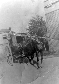
Photograph, Fred Lyons and his hansom cab
This is one of a series of photos donated by Arthur Lyons. From 1907 a cab service operated from near the railway gates in Union Road. It was established and maintained by Mr C Fraser until c1916. George Rea either took over then or set up in opposition. Fred Lyons initially worked for George until he set up his own business. In time he changed over to a motor vehicle and continued his service until 1960. Frederick Adolphus Lyons (1891-1980) was born in Surrey Hills, son of Thomas and Catherine Lyons. He married Elizabeth Ruby Hall in 1918. They lived just around the corner at 55 Sunbury Crescent. The Lyons’ home in Sunbury Crescent was called ‘Knopshambury’ - this was probably a misspelling of Knockshanbally in Co Kilkenny, the birth place of Fred’s father, Thomas Edmund Josias Lyons (1846-1915). Arthur Lyons was born in Surrey Hills on 12 Jun 1920. He became a motor mechanic / welder and lived at 55 Sunbury Crescent. The donation was made while he was in hospital. He died shortly afterwards (23 Sep 1990). Donation was finalised by a neighbour, Mrs Florence Ann Armitstead, wife of Glen Victor Armitstead. Glen was a local hairdresser. They moved to 11 Sunbury Crescent after their marriage in 1939. Arthur had no relatives to distribute the material to.Black and white photo of Fred Lyons with his hansom cab, taken between 1916-1920. It shows a horse harnessed to the cab, the door of which is open so that the buttoned seat is visible. The cab has large lamps on each side. Mr Lyons, in hat, is standing on the back of the cab. There is a large brick wall of a building to the right of the cab with a mature tree beside it and houses can be seen behind the cab. horse-drawn vehicles, carriages and coaches, fred lyons, george rea, frederick adolphus lyons -
 Surrey Hills Historical Society Collection
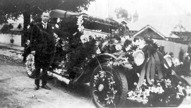
Photograph, Fred Lyons' taxi decorated for celebrations for Empire Day in 1930s, 1933-1938
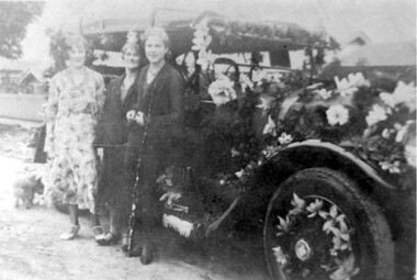
This is one of a series of photos donated by Arthur Lyons. From 1907 a cab service operated from near the railway gates in Union Road. It was established and maintained by Mr C Fraser until c1916. George Rea either took over then or set up in opposition. Fred Lyons initially worked for George until he set up his own business. In time he changed over to a motor vehicle and continued his service until 1960. Frederick Adolphus Lyons (1891-1980) was born in Surrey Hills, son of Thomas and Catherine Lyons. He married Elizabeth Ruby Hall in 1918. They lived just around the corner at 55 Sunbury Crescent. The Lyons’ home in Sunbury Crescent was called ‘Knopshambury’ - this was probably a misspelling of Knockshanbally in Co Kilkenny, the birth place of Fred’s father, Thomas Edmund Josias Lyons (1846-1915). Arthur Lyons was born in Surrey Hills on 12 Jun 1920. He became a motor mechanic / welder and lived at 55 Sunbury Crescent. The donation was made while he was in hospital. He died shortly afterwards (23 Sep 1990). Donation was finalised by a neighbour, Mrs Florence Ann Armitstead, wife of Glen Victor Armitstead. Glen was a local hairdresser. They moved to 11 Sunbury Crescent after their marriage in 1939. Arthur had no relatives to distribute the material to. Empire Day celebrations were held in Surrey Hills from 1906-1911; they were revived between 1933-1938 by the Surrey Hills Progress Association. They featured street parades with highly decorated vehicles provided by local businesses and bonfires, including the one in Beckett Park.Black and white photo of Mr Fred Lyons with his taxi decorated for Empire Day. The tourer car is parked in the street and is festooned with flowers and ribbons on the hood, bonnet radiator, running board and in the tyre spokes. Mr Lyons stands by the driver's side door. He is wearing a suit with a winged collar and tie. A small child is watching from the footpath on the left just behind a mature tree. There are houses in the background. empire day, motor vehicles, festivals and celebrations, taxis, fred lyons, frederick adolphus lyons -
 Surrey Hills Historical Society Collection
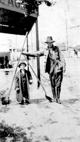
Photograph, Fred Lyons and his son Arthur after a hail storm, 1924, 1924
Lyons family history: Frederick Adolphus (Fred) Lyons operated a cab / taxi service in Union Road for several decades. Arthur was the only son of Frederick Adolphus Lyons (1891-1980) who was born in Surrey Hills, son of Thomas and Catherine Lyons. He married Elizabeth Ruby Hall in 1918. They lived at 55 Sunbury Crescent. The Lyons’ home was called ‘Knopshambury’ - this was probably a misspelling of Knockshanbally in Co Kilkenny, the birth place of Fred’s father, Thomas Edmund Josias Lyons (1846-1915).Arthur Lyons was born in Surrey Hills on 12 Jun 1920. He became a motor mechanic / welder and lived his whole life at 55 Sunbury Crescent. This is one of a series of photos donated by Arthur Lyons. The donation was made while he was in hospital. He died shortly afterwards (23 Sep 1990). Donation was finalised by a neighbour, Mrs Florence Ann Armitstead, wife of Glen Victor Armitstead. Glen was a local hairdresser. They moved to 11 Sunbury Crescent after their marriage in 1939. Arthur had no relatives to distribute the material to. The hail storm occurred on 2 December 1924.Despite the poor condition, this is significant because of the clear detail of the Union Road buildings and railway crossing in the background in 1924.Black and white photo of cab driver Fred Lyons with his son Arthur taken at the cab rank near the Surrey Hills station, clearing up after a hail storm in 1924. Fred balances 2 large shovels; Arthur has an over-sized jacket on. The railway gates and overhead lines can be clearly seen in the background. Despite the poor condition, it is a relatively significant photo as it details Union Road buildings and the railway crossing clearly behind it.On back of photo is written in pencil "copied 1996" and in blue pen "2/12/24"railway crossings, hail storms, frederick adolphus lyons, fred lyons, arthur frederick lyons, arthur lyons -
 Surrey Hills Historical Society Collection
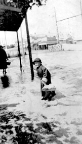
Photograph, Arthur Lyons in Union Road after a hail storm, 1924, 1924
The hail storm occurred on 2 December 1924. This is one in a series from the Lyons' photo collection. This was gifted to the SHNCHC by Arthur Frederick Lyons, son of Frederick Alphonsus (Fred) Lyons and Elizabeth Ruby Hall, who married in 1918. Fred Lyons died 4/10/1980. The Lyons’ home in Sunbury Crecent was called ‘Knopshambury’ - this was probably a misspelling of Knockshanbally in Co Kilkenny, the birth place of Fred’s father, Thomas Edmund Josias Lyons (1846-1915). Arthur was born in Surrey Hills on 12 Jun 1920. He became a motor mechanic / welder and lived at 55 Sunbury Crescent. The donation was made while he was in hospital. He died shortly afterwards (23 Sep 1990). Donation was finalised by a neighbour, Mrs Florence Ann Armitstead, wife of Glen Victor Armitstead. Glen was a local hairdresser. They moved to 11 Sunbury Crescent after their marriage in 1939. Arthur had no relatives to distribute the material to.Historically significant as it shows clearly the buildings and railway crossing in Union Road.Black and white photo of Arthur Lyons as a child with a shovel in hand taken at the cab rank near the Surrey Hills station, clearing up after a hail storm in 1924. The railway gates and overhead lines can be seen in the background. On back in pencil was "Copied 1996" and also "2/12/1924"railway crossings, hail storms, arthur lyons -
 Surrey Hills Historical Society Collection
Photograph, Fred and Arthur Lyons, c 1926, 1926
The date of 1926 is approximate and the location is almost certainly outside the Lyons' home in Sunbury Crescent. Arthur Lyons was known as 'Tiger'. This is one of a series of photos donated by Arthur Lyons. From 1907 a cab service operated from near the railway gates in Union Road. It was established and maintained by Mr C Fraser until c1916. George Rea either took over then or set up in opposition. Fred Lyons initially worked for George until he set up his own business. In time he changed over to a motor vehicle and continued his service until 1960. Frederick Adolphus Lyons (1891-1980) was born in Surrey Hills, son of Thomas and Catherine Lyons. He married Elizabeth Ruby Hall in 1918. They lived just around the corner at 55 Sunbury Crescent. The Lyons’ home in Sunbury Crescent was called ‘Knopshambury’ - this was probably a misspelling of Knockshanbally in Co Kilkenny, the birth place of Fred’s father, Thomas Edmund Josias Lyons (1846-1915). Arthur Lyons was born in Surrey Hills on 12 Jun 1920. He became a motor mechanic / welder and lived at 55 Sunbury Crescent. The donation was made while he was in hospital. He died shortly afterwards (23 Sep 1990). Donation was finalised by a neighbour, Mrs Florence Ann Armitstead, wife of Glen Victor Armitstead. Glen was a local hairdresser. They moved to 11 Sunbury Crescent after their marriage in 1939. Arthur had no relatives to distribute the material to.Black and white photo of Fred Lyons with his son, Arthur sitting on the pavement in front of a wooden picket fence. Fred is dressed in a white coat and a cap.Pencilled on the back "copied 1996" Printed in black 'VELOX KODAK PRINT'fred lyons, frederick adolphus lyons, arthur lyons, arthur frederick lyons, sunbury crescent -
 Surrey Hills Historical Society Collection
Photograph, Fred Lyons with son Arthur of Surrey Hills
This is one of a series of photos donated by Arthur Lyons. From 1907 a cab service operated from near the railway gates in Union Road. It was established and maintained by Mr C Fraser until c1916. George Rea either took over then or set up in opposition. Fred Lyons initially worked for George until he set up his own business. In time he changed over to a motor vehicle and continued his service until 1960. Frederick Adolphus Lyons (1891-1980) was born in Surrey Hills, son of Thomas and Catherine Lyons. He married Elizabeth Ruby Hall in 1918. They lived just around the corner at 55 Sunbury Crescent. The Lyons’ home in Sunbury Crescent was called ‘Knopshambury’ - this was probably a misspelling of Knockshanbally in Co Kilkenny, the birth place of Fred’s father, Thomas Edmund Josias Lyons (1846-1915). Arthur Lyons was born in Surrey Hills on 12 Jun 1920. He became a motor mechanic / welder and lived at 55 Sunbury Crescent. The donation was made while he was in hospital. He died shortly afterwards (23 Sep 1990). Donation was finalised by a neighbour, Mrs Florence Ann Armitstead, wife of Glen Victor Armitstead. Glen was a local hairdresser. They moved to 11 Sunbury Crescent after their marriage in 1939. Arthur had no relatives to distribute the material to.A black and white photograph of Arthur Lyons standing by his father who is seated with a fox terrier on his lap. They are in front of a paling fence which in turn is in front of a brick building with a veranda. On the back in black pen " Lyons/Sunbury Cres" and in pencil "copied 1996"taxis, drivers, sunbury crescent, surrey hills, fred lyons, frederick adolphus lyons, arthur lyons, arthur frederick lyons -
 Surrey Hills Historical Society Collection
Photograph, Fred Lyons' taxi decorated for celebrations for Empire Day in 1930s, 1933-1938
Lyons family history: From 1907 a cab service operated from near the railway gates in Union Road. It was established and maintained by Mr C Fraser until c1916. George Rea either took over then or set up in opposition. Fred Lyons initially worked for George until he set up his own business. In time he changed over to a motor vehicle and continued his service until 1960. Frederick Adolphus Lyons (1891-1980) was born in Surrey Hills, son of Thomas and Catherine Lyons. He married Elizabeth Ruby Hall in 1918. They lived just around the corner at 55 Sunbury Crescent. The Lyons’ home in Sunbury Crescent was called ‘Knopshambury’ - this was probably a misspelling of Knockshanbally in Co Kilkenny, the birth place of Fred’s father, Thomas Edmund Josias Lyons (1846-1915). Arthur Lyons was born in Surrey Hills on 12 Jun 1920. He became a motor mechanic / welder and lived at 55 Sunbury Crescent. Empire Day celebrations were held in Surrey Hills from 1906-1911 and revitalised from 1933-1938 by the Surrey Hills Progress Association. Street parades featuring decorated business vehicles and bonfires were a feature. This is one of a series of photos donated by Arthur Lyons.The donation was made while he was in hospital. He died shortly afterwards (23 Sep 1990). Donation was finalised by a neighbour, Mrs Florence Ann Armitstead, wife of Glen Victor Armitstead. Glen was a local hairdresser. They moved to 11 Sunbury Crescent after their marriage in 1939. Arthur had no relatives to distribute the material to. Empire Day celebrations were held in Surrey Hills from 1906-1911 and revitalised by the Surrey Hills Progress Association from 1933-1938. The evening parade of floats, and vehicles both horse-drawn and motorised, proceeded along Union Road to the Surrey Gardens beneath festoons of candlelit lanterns, bunting and flags. The paper flowers used extensively on trade and business vehicles were the result of hours of work by families and friends. The Empire Day Celebrations were a great community event, in some years augmented by bonfires, including the ones in Beckett Park.Black and white photo of Fred Lyons' taxi decorated for Empire Day. The cab is parked in the street and is festooned with flowers and ribbons on the hood, bonnet radiator, running board and in the tyre spokes. Three women stand beside the cab. There are houses in the background. motor vehicles, festivals and celebrations, taxis, empire day, fred lyons, frederick adolphus lyons -
 Surrey Hills Historical Society Collection
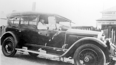
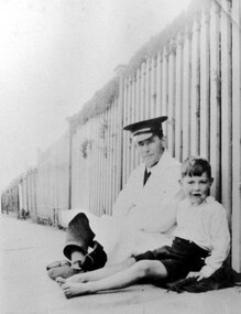
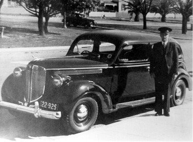
Photograph, Fred Lyons, taxi driver of Surrey Hills
This is one of a series of photos donated by Arthur Lyons. From 1907 a cab service operated from near the railway gates in Union Road. It was established and maintained by Mr C Fraser until c1916. George Rea either took over then or set up in opposition; he retired in 1945. Fred Lyons initially worked for George until he set up his own business. In time he changed over to a motor vehicle and continued his service until 1960. Frederick Adolphus Lyons (1891-1980) was born in Surrey Hills, son of Thomas and Catherine Lyons. He married Elizabeth Ruby Hall in 1918. They lived just around the corner at 55 Sunbury Crescent. The Lyons’ home in Sunbury Crescent was called ‘Knopshambury’ - this was probably a misspelling of Knockshanbally in Co Kilkenny, the birth place of Fred’s father, Thomas Edmund Josias Lyons (1846-1915). Arthur Lyons was born in Surrey Hills on 12 Jun 1920. He became a motor mechanic / welder and lived at 55 Sunbury Crescent. The donation was made while he was in hospital. He died shortly afterwards (23 Sep 1990). Donation was finalised by a neighbour, Mrs Florence Ann Armitstead, wife of Glen Victor Armitstead. Glen was a local hairdresser. They moved to 11 Sunbury Crescent after their marriage in 1939. Arthur had no relatives to distribute the material to.Black and white photo of Fred Lyons dressed in suit and cap standing on the footpath beside his taxi. Behind the taxi is another car approaching from a street at right angles. There are wide stretches of grass planted with trees including palm trees. In the background are houses with picket fences; the most visible house is clearly Victorian in style. transport, businesses, taxis, fred lyons, frederick adolphus lyons, uniforms -
 Surrey Hills Historical Society Collection
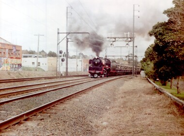
Photograph, A Yarra Glen Special approaching Surrey Hills, 1986
A Yarra Glen Special in 1986 at Surrey HillsA coloured photograph of a steam train bellowing lots of smoke approaching Surrey Hills station. On the LHS is Stirling Crescent; on the RHS is Sunbury Crescent. There is graffiti on the buildings adjacent to the railway line on the LHS.On rear of photo : "A Yarra Glen Special / 1986/ at Surrey Hills"graffiti, surrey hills, steam train, trains, 1986, harris carriages -
 Surrey Hills Historical Society Collection
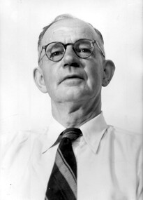
Photograph, Fred Lyons, cab and taxi proprietor, Surrey Hills
This is one of a series of photos donated by Arthur Lyons. From 1907 a cab service operated from near the railway gates in Union Road. It was established and maintained by Mr C Fraser until c1916. George Rea either took over then or set up in opposition. Fred Lyons initially worked for George until he set up his own business. In time he changed over to a motor vehicle and continued his service until 1960. Frederick Adolphus Lyons (1891-1980) was born in Surrey Hills, son of Thomas and Catherine Lyons. He married Elizabeth Ruby Hall in 1918. They lived just around the corner at 55 Sunbury Crescent. The Lyons’ home in Sunbury Crescent was called ‘Knopshambury’ - this was probably a misspelling of Knockshanbally in Co Kilkenny, the birth place of Fred’s father, Thomas Edmund Josias Lyons (1846-1915). Arthur Lyons was born in Surrey Hills on 12 Jun 1920. He became a motor mechanic / welder and lived at 55 Sunbury Crescent. The donation was made while he was in hospital. He died shortly afterwards (23 Sep 1990). Donation was finalised by a neighbour, Mrs Florence Ann Armitstead, wife of Glen Victor Armitstead. Glen was a local hairdresser. They moved to 11 Sunbury Crescent after their marriage in 1939. Arthur had no relatives to distribute the material to.A black and white studio portrait of a man wearing round eye glasses, a white shirt and dark coloured striped tie.George Lyonssunbury crescent, surrey hills, union street, taxi proprietor, fred lyons, frederick adolphus lyons -
 Surrey Hills Historical Society Collection
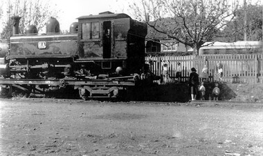
Photograph, Narrow Gauge Loco 6A on transporter wagon in goods yard at Surrey Hills, 12/05/1950
The engine was being transported because it had broken a coupling in transit. Windsor Crescent is in the background. We have an original copy donated by Ian Barkla and a larger one copied by Ken Hall. The Barkla original has a sticker with his reference details on the back.A black and white photocopy of a steam engine. There are some local kinder children and an adult inspecting the train and climbing on the picket fence. The house in the background is in Windsor Crescent.surrey hills railway station, goods yard, steam train, transporter wagon, 1950, children, clothing and dress -
 Surrey Hills Historical Society Collection
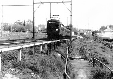
Photograph, At Surrey Hills - Railfan tour to Belgrave for the South Pacific Electric Railway Group, 1 October 1966
We have an original copy donated by Iam Barkla and a larger one copied by Ken Hall. The Barkla original has a sticker with his reference details on the back. The occasion was a Railfan tour for the South Pacific Electric Railway Group to Belgrave. Photo taken on 1 October 1966. A black and white photo of an electric train near the Surrey Hills railway station. The shops in Union Road, the pedestrian overpass at the station and houses in Windsor Crescent can be seen in the background.surrey hills railway station, railfan tour, south pacific electric railway group, 1966, union road shops, windsor crescent -
 Surrey Hills Historical Society Collection
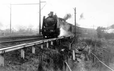
Photograph, Loco N 468 at Surrey Hills on Railfan Tour to Healesville for the Australia Railway Enthusiasts Group, 1 October 1966
We have an original copy donated by Iam Barkla and a larger one copied by Ken Hall. The Barkla original has a sticker with his reference details on the back. The occasion was a Railfan tour to Healesville for the Australian Railway Enthusiasts Group. Photo taken on 1 October 1966. A black and white photo of steam train. Some of the houses in WIndsor Crescent can be seen on the left hand side of the photograph; also some of the Union Road shops and the pedestrian overpass at the Surrey Hills station.surrey hills railway station, 1966, railfan tour, australia railway enthusiasts group, union road shops, windsor crescent -
 Surrey Hills Historical Society Collection
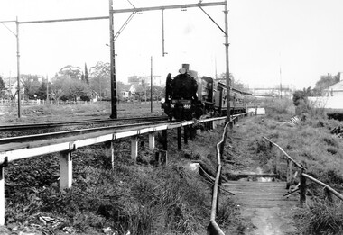
Photograph, Loco K176 at Surrey Hills on a vintage tour train to Healesville, 1 October 1966, 1 October 1966
We have an original B&W copy donated by Ian Barkla and a larger one copied by Ken Hall. The Barkla original has a sticker with his reference details on the back. The photo records a Vintage Train tour to Healesville on 1 October 1966. The Lilydale to Healesville line opened on 1 March 1889. The last steam train on the line ran in 1957 and the last passenger service was in 1980. The line reopened as a tourist railway in 2010. Although the photo was taken on a misty day, houses in Windsor Crescent can just be seen in the background. It is possibly Lorne Parade in the background with preparatory works for the 3rd rail line underway.A black and white photocopy of a steam train. One person is looking on from the left hand side of the photo. It's a misty day but houses in Windsor Crescent and the pedestrian overpass at Surrey Hills railway station can be seen.surrey hills railway station, windsor cresent, 1966, railfan tour, steam trains, vintage tour train