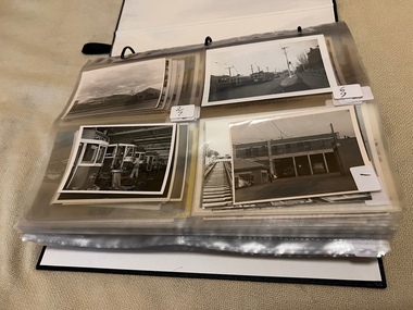
Showing 632 items
matching river st
-
 Whitehorse Historical Society Inc.
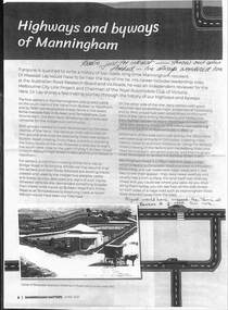
Article - Manningham Matters, Dr Richard Lay, Highways and Byways of Manningham, June 2021
... at Northcote and Mitcham and probably crossed the Yarra River... and probably crossed the Yarra River at the Banksia St bridge and took ...August Schwerkolt walked between his properties at Northcote and Mitcham and probably crossed the Yarra River at the Banksia St bridge and took the ridge route which is now the Manningham, Doncaster and Mitcham Roads.August Schwerkolt walked between his properties at Northcote and Mitcham and probably crossed the Yarra River at the Banksia St bridge and took the ridge route which is now the Manningham, Doncaster and Mitcham Roads.non-fictionAugust Schwerkolt walked between his properties at Northcote and Mitcham and probably crossed the Yarra River at the Banksia St bridge and took the ridge route which is now the Manningham, Doncaster and Mitcham Roads.schwerkolt august, mitcham, doncaster road, mitcham road -
 Warrnambool and District Historical Society Inc.
Postcard - Views of Warrnambool
... pictures are, The Beach. Hopkins River. Thunder Point. Liebig St... are, The Beach. Hopkins River. Thunder Point. Liebig St. Botanical ...Pictures depicting scenes of Warrnambool & District. 9 pictures are, The Beach. Hopkins River. Thunder Point. Liebig St. Botanical Gardens. Breakwater and pier. Hopkins River. Soldiers Memorial. Hopkins Falls.A typical souvenir postcard from the 1930'sOblong postcard with flip down views of Warrnambool from a purse with two kittensValentine's Mail Novelty Post Card; Good Luck And a Bagful of Views from WARRNAMBOOLwarrnambool, hopkins river, warrnambool breakwater, warrnambool postcards, postcards, hopkins falls, thunder point, soldiers memorial -
 Melbourne Legacy
Slide - Slides, Comradeship songs
... Swannee River Bell's of St Mary's Nursie Little brown jug... River Bell's of St Mary's Nursie Little brown jug A record ...The subject of these slides is not known until they are looked at again, their titles could give clues to the contents. Some titles that can be seen are; Tavern in the Town, I love you truly, The old spinning wheel The good old summer time Swannee River Bell's of St Mary's Nursie Little brown jugA record of the types of songs sung by Legatees at Comradeship gatherings. Comradeship meetings were very important to the Legatees. Legatees supported each other by coming together for various events throughout the year. Coloured 35mm slides, coloured photo surrounded by cardboard border.Various titles of songs on individual slides.comradeship, songs -
 Ballarat Tramway Museum
Photograph - Black & White Photograph/s, mid to Late 1965
... paper. 1420.1 - Bridge Road looking east at River St. crossover... paper. 1420.1 - Bridge Road looking east at River St. crossover ...Set of seven Black and white photographs of the arrangements and work for the track reconstruction at the intersection of Hoddle St/Punt Rd and Bridge Road Richmond late 1965. On Kodak paper. 1420.1 - Bridge Road looking east at River St. crossover (Hawthorn bridge in distant background). Tram-bus connection at a weekend. Note driver's uniform. Conductor walking to bus with passengers. Conductors often worked through on the bus and next tram at this time to save crews. 1420.2 - Bridge Road at Punt Rd and Hoddle St. intersection looking north west. Reconstruction of curves. Would probably be a Sunday given that new rails are in situ. 1420.3 - Ditto - looking south east 1420.4 - looking south east 1420.5 - looking east - replacement bus service passing with old cable winding house in the background. Concrete being placed. 1420.6 - Wellington Parade at Simpson St. crossover looking east. Bus-tram connection. Bus 542 and tram 966 (Kew Depot) 1420.7 - ditto - bus 570 and tram 850 (Camberwell). See P.Winspur note - see data sheet for Reg. item 1418.trams, tramways, bridge road, tram - bus connections, trackwork, mmtb, tram 939, tram 966, tram 850 -
 Melbourne Tram Museum
Photograph - Illustration, c1916
... of the river Yarra, Flinders St railway yard, the viaduct, the swing... reproduced in a magazine of the river Yarra, Flinders St railway yard ...Illustration from a photograph reproduced in a magazine of the river Yarra, Flinders St railway yard, the viaduct, the swing basin, the wharves and Queens Bridge. Has a number of cable cars and trains in the view. Taken prior to the construction of the second or duplicate viaduct which was completed during 1915. Construction of the second viaduct on the south side of the original can be seen.in ink in bottom right hand comer "By 1916"trams, tramways, flinders st, railways, shipping, cable trams -
 Lorne Historical Society
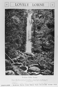
Pamphlet - Tourist Brochure, Lovely Lorne
... fold are 6 black and white photographs, Cumberland River, Mt St... River towards the main beach. , on the back is a black and white ...The Victorian Railways promoted tourist destinations around Victoria. A folded paper tourist brochure about Lorne The front cover is a coloured painting of Lorne from above the Erskine River towards the main beach. , on the back is a black and white sketch tourist map of the roads, tracks and beauty spots. Inside the first fold are 6 black and white photographs, Cumberland River, Mt St George, Phantom Falls, Cumberland Cliffs, Teddy’s Lookout, leafy walk towards the pier. Inside contains written descriptions of the highlights of Lorne and six black and white photographs, four general views of Lorne, Lover’s Walk, Erskine Falls . souvenirs, victorian railways, publicity -
 Melbourne Tram Museum
Postcard, Traveller's Notes, 4 panel full colour - by Traveller's Notes, 1997
... , of the Yarra River, Cook's Cottage, Flinders St Station main entrance... Trams tramways Flinders St Station Yarra River SW6 class Route 5 ...Postcard - 4 panel full colour - by Traveller's Notes, of the Yarra River, Cook's Cottage, Flinders St Station main entrance, and SW6 852, University, route 5. Divided back, published by Traveller's Notes, photos by Neil J Leed, 1997.trams, tramways, flinders st station, yarra river, sw6 class, route 5, tram 852 -
 Melbourne Tram Museum
Photograph - Digital Image, Kevin O'Reilly, series of three images of the Hawthorn Bridge over the Yarra, c1930, c1930's
... south along River St towards Bridge Road, with the Yarra River... south along River St towards Bridge Road, with the Yarra River ...Image from CD (Compact Diskette for use in computers) - see Reg Item 135. A series of three images of the Hawthorn Bridge over the Yarra, c1930, during the era with problems with the bridge. See separate article for more details. Richmond 6, Richmond, Richmond 3 on the CD as original files. .1 - Looking from the south west, at the Hawthorn bridge with the temporary wooden bridge being constructed on the south side. Has the cable tram depot in the photo and part of the Burnley racing course. Temporary track on the north side of the steel bridge and crossings can be seen. .2 - Looking along Bridge Road to the east with Hawthorn Bridge in the middle of the photograph. Shows the industrial and residential areas, Hawthorn Railway Station and part of the Burnley Race course, the cable tram depot building. W class tram in Church St Hawthorn and W class tram crossing the bridge on the north side temporary track. Note the cable tram used as a shelter on the north east corner of the bridge. .3 - Looking south along River St towards Bridge Road, with the Yarra River and Hawthorn Bridge on the left side of the photograph. Shows the industry in the area at the time, wool and skin Merchants, north side of the cable depot, housing and the outlook to the river!trams, tramways, hawthorn, yarra river, burnley, richmond, hawthorn bridge -
 Melbourne Tram Museum
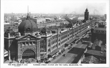
Postcard, Rose Stereograph Co, "Flinders Street Station and the Yarra, Melbourne", late 1920s
... the Yarra river. The St Kilda/Port Melbourne and Queens bridge... of Melbourne late 1920s tramways trams Flinders St Station Yarra River ...Rose Series postcard No. P 1666, titled "Flinders Street Station and the Yarra, Melbourne". This photo is looking southwest from St Paul's Cathedral over the station building along the Yarra river. The St Kilda/Port Melbourne and Queens bridge are in view, but not the Spencer St bridge which was built during the late 1920s. The AW Allen's Limited Confectionary Factory constructed in 1923-24 on Riverside Avenue dominates the landscape on the south side of the river directly behind the dome of the Flinders Street railways station. One very long set of horse-drawn carts can be seen alongside the center entrance to the railway station building in Flinders Street.Yields information about an aerial view of Melbourne late 1920sPostcard - printed real photograph with Rose Stereograph Co. name on the rear.tramways, trams, flinders st station, yarra river, bridges, railways, flinders st -
 Melbourne Tram Museum
Album - Robert Thomson Slide Collection, AETA Convention 1970
... - "Special" RT096 Reserve track running alongside River St... - "Special" RT096 Reserve track running alongside River St ...Photo - see pdf file for further information. Number Brief Description RT091 Burke Road Camberwell south of the Junction but before Inglesby St. W7 No. 1007 Destination "Special". RT092 Riversdale Road Camberwell Junction - SW6 No. 933 - "City" - route 70 RT093 Miller Street outside the Preston Workshops - W2 No. 597 - "City - Spencer St" - route 9A RT094 West Maribyrnong Terminus SW6 No. 927 - "City via North Melb." - route 57 plus Y class No. 469 - "City" RT095 Queens Way St. Kilda. PCC No. 980 - "Special" RT096 Reserve track running alongside River St. Maribyrnong Y class No. 469 west bound - "Hawthorn Depot" RT097 Footscray Terminus Leeds Street Y class No. 469 - "Special" RT098 Brunswick Depot - various trams including W3 No. 657 - W5 No. 755 "Moreland" route 20 & W5 No. 732 "Moreland" route 15. RT099 North Fitzroy Depot AETA - buses 543, 551 & 583 All AEC Mk 3's RT100 Port Melbourne Station with four car "Harris" set. RT101 St Kilda Station with four car "Harris" set. RT102 Preston Workshops W2 No. 397 - route 01 (01 overhaul) plus another W2 and a Y1 RT104 Preston Workshops, W5 No 681 - not long after a repaint. RT105 Preston Workshops, Freight car No. 19 RT106 Preston Workshops, various cars of different classes. nearest is W5 No. 793 Route 03 (03 overhaul) Demonstrates the work of Robert Thomson in photography, collection and/or production of slidesAssembled album in a black presentation folder of 16 colour slides, collected or produced by Robert Thomson. All photographs have been scanned and placed on the Museum's G drive. A list of all photographs with details has been compiled. melbourne, tramways, trams, aeta, mmtb, preston workshops, miller st, footscray, leeds st, burke rd, west maribyrnong, camberwell junction, brunswick depot, north fitzroy depot, buses, mmtb buses, aec mk iii, w2 class, w3 class, sw6 class, w7 class, w5 class, tram 793, tram 19, tram 1007, tram 681, tram 397, tram 657, tram 469, y class, tram 980, pcc class, queens way, tram 933, riversdale road, camberwell, tram 755, tram 732, bus 543, bus 551, bus 583, port melbourne railway, railways, route 70, route 57, route 15, route 20, route 9a -
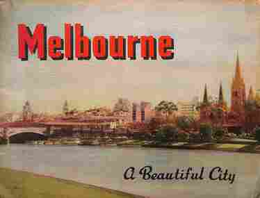 Melbourne Tram Museum
Book, Nucolorvue Publishing, "Melbourne - a Beautiful City", c1953
... Beach, Yarra River, and Elizabeth St.... River, and Elizabeth St. Demonstrates a Nucolorvue production ...Published by Nucolorvue Productions of Mentone Melbourne, c1953 featuring colour photos of many locations in Melbourne, including an introduction. Has photos of Melburne landmarks, Collins St, Flinders St, Bourke St (with cable tram track), Flinders St Station, trams in streets, (W2 389, W5 777) St Kilda Road, the various parks, Royal Melbourne Hospital, St Kilda Beach, Yarra River, and Elizabeth St.Demonstrates a Nucolorvue production about Melbourne in the early 1950s.Book - 36 pages, colour printed, centre stapled. Printed on stippled paper.Has the stamp of "Queensland Book Depot, 61 Adelaide St Brisbane" on the inside front cover and pencil notes.mmtb, trams, tramways, souvenirs, melbourne, travel books -
 Federation University Historical Collection
Plan, R. Underwood, Shire of Winchelsea, 1952, 10/10/1952
... , barwon downs, kaanglang, st george river, cumberland creek, stony..., Barwon River, Thompson's Creek, Bass Straight. Mt Defiance, Mt St..., kaanglang, st george river, cumberland creek, stony creek, bambra ...Copy of a plan of the Shire of Winchelsea including Lake Wollard, Wormbete, angahook, boonah, Barwon Downs, Kaanglang, St Gerge River, Cumberland Creek, Stony Creek, Bambra, Wensleydale, yan Yan Gurt, Tutegong, Mirnee, Karngun, whoorel, Birregurra, Barwon River, Thompson's Creek, Bass Straight. Mt Defiance, Mt St George, Loutit Bay, Airey's Inlet, Salt Creek, Mathew's Creek.winchelsea, lake wollard, wormbete, angahook, boonah, barwon downs, kaanglang, st george river, cumberland creek, stony creek, bambra, wensleydale, yan yan gurt, tutegong, mirnee, karngun, whoorel, birregurra, barwon river, thompson's creek, bass straight. mt defiance, mt st george, loutit bay, airey's inlet, salt creek, mathew's creek, r. underwood, why river, point sturt, barwon downs, forest -
 Melbourne Tram Museum
Photograph - Digital Image, Kevin O'Reilly, Richmond looking east along the Yarra River, c1930's
... east along the Yarra River where the Church St Bridge Richmond... Trams tramways Richmond Chapel St Church St Yarra River Image ...Image from CD (Compact Diskette for use in computers) - see Reg Item 135. Image titled "Richmond 7" on CD, of looking east along the Yarra River where the Church St Bridge Richmond crosses the River, Alexandra Ave. Has an ex HTT Maximum Traction tram crossing the bridge. Shows now Herring Island after the Yarra River was cut through to form the island.trams, tramways, richmond, chapel st, church st, yarra river -
 Bendigo Historical Society Inc.
Administrative record - Abbott Collection: Jan to Jun 1893: records and receipts for purchases by J.H. Abbott & Co
... , Curriers & Leather Merchants; Tannery, River St., near Hawthorn..., Curriers & Leather Merchants; Tannery, River St., near Hawthorn ...various 1893 company letterhead receipts2403.86 (A to G) Abbott Collection: Jan to Jun 1893: records and receipts for purchases by J.H. Abbott & Co. from a wide range of generally Melbourne based companies 2043.86A 40 records held by J.H. Abbott & Co. Jan to Jun 1893: for purchases (or sales) 2403.86B 10 receipts for purchases by J.H. Abbott & Co. from Thomas P. Power, Saddlers, Ironmongers & Manufacturers398-400 Little Bourke St Melbourne 2403.86C 10 receipts for purchases by J.H. Abbott from The India Rubber, Gutta Percha & Telegraph Works Co. 106 Cannon St London 2403.86D 4 receipts for purchases by J.H. Abbott & Co. from Cashel, Baxter & Co., 508 Collins Str Melbourne 2403.86E 7 receipts for purchases by J.H. Abbott from Ullathorne & Co., 269 Lonsdale St Melbourne 2403.86F 5 receipts for purchases by J.H. Abbott from Michaelis, Hallenstein & Co, Tanners, Curriers & Leather Merchants, Importers of Grindery, 382-384 Lonsdale St Melbourne 2403.86G 14 receipts for purchases by J.H. Abbott from a variety of companies: Nobel's Hamburg Dynamite Co. Ltd. - gelignite Thomas Mitchell, Paint & General Brush Manufacturers357 Lonsdale St Melbourne R.M. Watson & Co. 345 Flinders Lane Melbourne; Paper Makers, Agents, Stationers and Importers (two receipts) Wm Dodgshun & Sons, 258 &260 Flinders Lane, East Melbourne; Importers & Warehousemen (two receipts) The New Zealand Loan & Mercantile Agency Company Limited, Collins Street West, Melbourne; Melbourne Wool & Grain Warehouses Walter H. Carwardine, Bendigo Soap, Soda Crystal & candle Works, near the Municipal Cattle Yards J. Kitchen & Sons & Apollo Company; 326 Flinders Lane, Melbourne J. Kennon & Sons, Tanners, Curriers & Leather Merchants; Tannery, River St., near Hawthorn Bridge Innes - Noad V. Halfden (!!!), Tea Merchants & Importers; 201 1to 205 William Street, Melbourne The Indian Company, Lubricating Oil Merchants; Normanby Road, South Melbourne; 375 Flinders Lane, corner Queen Street, Melbourne A. Spooner Manufacturer of Improved Harness Composition, Improved Black Oil, Harness Liquid, Waterproof Harness Blacking, saddle Soap, Boot Top Powder (all colours), Polishing Cream, Breeches Paste, Universal Cream and Embrocations. Australian Asbestos Mfg Co. 266 Flinders St Easttrade company purchases 1893 -
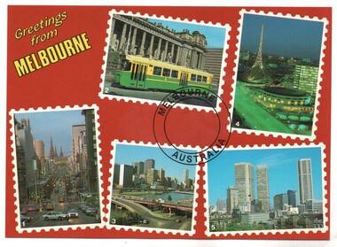 Melbourne Tram Museum
Postcard, Biscay Greetings, Set of five photos of Melbourne trams, mid 1980's
... along Bourke St, the Yarra River overlooking the King St bridge..., the Yarra River overlooking the King St bridge and the city ...Colour postcard divided back - Biscay Greetings, series of 5 photographs of Melbourne, with the words "Greetings from Melbourne" in the top right hand corner. Features Z3 223 class tram outside Parliament, the Arts Centre, a view looking east along Bourke St, the Yarra River overlooking the King St bridge and the city and a general city photo. For the photo of Z3 223, see Reg item 2642. Back has space for name and address, stamp and a message and details of the postcard. Produced by Biscay Greetings, possibly mid 1980's. Card No. BG 178.trams, tramways, postcards, yarra river, z class, melbourne, tram 223 -
 University of Melbourne, Burnley Campus Archives
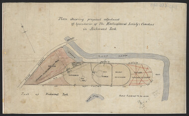
Plan, John S. Jenkins, Plan showing proposed adjustment of boundaries of the Horticultural Society's Gardens in Richmond Park, c.1880-1884
... by Swan St., Yarra River and part of Richmond Park, coloured areas... by Swan St., Yarra River and part of Richmond Park, coloured areas ...Plan on linen fibre cloth. Shows layout of Burnley bound by Swan St., Yarra River and part of Richmond Park, coloured areas showing proposed area to be added to Park, the old road, shrubbery, new hall, old garden, recent extension and proposed further extension (crossed out in red ink). Scale 4 chains:1 inch. Probably drawn by John S. Jenkins, Town Surveyor, Richmond. Has been photographed so that additional copies can be made. On a CD plus 3 negatives, plus small coloured print. (Also copy glazed and framed for Centenary Exhibition - B92.0540.)john s. jenkins, gardens, richmond, hoticultural society of victoria -
 Ballarat Tramway Museum
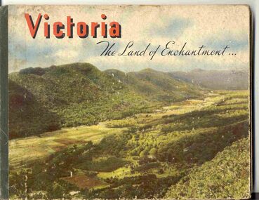
Book, Nu-color-vue or Nucolorvue Productions, "Victoria The Land of Enchantment", c1950
... , Mornington Beach, Yarra River, Flinders St. station from the Yarra..., Yarra River, Flinders St. station from the Yarra, Collins ...Book with hardcovers, 48 pages titled "Victoria The Land of Enchantment". Sewn in three sections, with a green strip of cloth and self end papers and printed outer paper, sides glued onto board covers. Consists of 43 colour photographs (full and half page) with captions, detailed text, and two black and white photos printed in blue on end covers. Photos of Mt Buffalo, Gippsland lakes, Mornington Beach, Yarra River, Flinders St. station from the Yarra, Collins and Spring St (with two W2's - see image No. 2), Parliament House, Kiewa Hydro scheme, Eildon Weir, Swan Hill Murray River Bridge, Bendigo Post Office, Melbourne Botanical Gardens, Ballarat - Grenville and Sturt St (No. 22 - see image No. 3), Lorne, Yallourn Power Station, Hume Weir, Maroondah Weir, Great Ocean Road, Warrnambool, Portland Beach, A timber train (see image No. 4), Mildura, flax mills, Eastern Geelong and the Prime Ministers Ave, Ballarat. Produced by Nucolorvue Productions, c1950. See also Reg Item 2925 for the same photo of No. 22 and Reg Item 5354 for a postcard. Purchased via eBay site - see attached sheets and packing slip. Purchased 10/2/2005 for A$12.50 including postage, from Virginia Georgopoulos of West Brunswick. eBay sheets and envelope with worksheet file. Has Swains 123 Pitt St, Sydney sticker on bottom left hand corner page 2trams, tramways, ballarat, sturt st, grenville st, bogie trams, geelong, bendigo, melbourne -
 National Wool Museum
Album - Photo Album, 2 of 3, J W Allen, 1928-1929
... St Lawrence River...-Pocatière and St Lawrence River. Properties depicted include Kenton..., Sainte-Anne-de-la-Pocatière and St Lawrence River. Properties ...This album is one of three albums compiled and owned by J W Allen, Secretary of New South Wales Grazier's, and is associated with the New South Wales Graziers Association world tour of sheep 1928-1929. This album contains photographs of travel, sheep, farms, stations, people and landscapes from around the world. Locations include Kenya, Kinangop, Naivasha, Elementeita, Lake Nakuru, Njoro, Namibia, Otjihavera, Mt Kenya, Isiolo, Yemen, Aden, Suez, River Jordan, Jerusalem, Hebron, Bethlehem, Beersheba, Galilee, Lake Tiberias, Mt Hermon, Canada, Mt Robson, Fraser River Canyon, British Columbia, Merrit, Canford, Alberta, Cardston, Pekisko Creek, Turner Valley, Calgary, Saskatoon, Manitoba, Winnipeg, Portage la Prairie, Niagara Falls, Quebec, Sainte-Anne-de-la-Pocatière and St Lawrence River. Properties depicted include Kenton Estates, Kekopey Ranch, Soysambu Ranch, Larmudiac, SX Ranch, Neilson's Ranch, EP Ranch and CX Ranch. The album was found in a clean out at the Great Southern Agricultural Research Institute and donated to the National Wool Museum, along with other related material such as photographs, glass lantern slides and ephemera.Photo album with card cover and silk string binding. Inside are twenty four pages of brown carded paper with black and white photos and hand written black text. A white piece of paper with hand written text has been added to the inside front page.new south wales graziers association, world tour, sheep, farm, rural, agriculture, ranch, travel, kenton estates, kekopey ranch, soysambu ranch, larmudiac, sx ranch, neilson's ranch, ep ranch, cx ranch, kenya, kinangop, naivasha, elementeita, lake nakuru, njoro, namibia, otjihavera, mt kenya, isiolo, yemen, aden, suez, river jordan, jerusalem, hebron, bethlehem, beersheba, galilee, lake tiberias, mt hermon, canada, mt robson, fraser river canyon, british columbia, merrit, canford, alberta, cardston, turner valley, pekisko creek, calgary, saskatoon, manitoba, winnipeg, portage la prairie, niagara falls, quebec, sainte-anne-de-la-pocatiere, st lawrence river -
 National Wool Museum
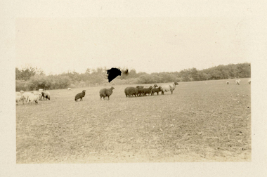
Photograph - Karakul Sheep, J W Allen, 1928-1929
... , Quebec, Sainte-Anne-de-la-Pocatière and St Lawrence River...-Pocatière and St Lawrence River. Properties depicted include Kenton ...This photograph was found loose in the second of three albums compiled and owned by J W Allen, Secretary of New South Wales Grazier's, and is associated with the New South Wales Graziers Association world tour of sheep 1928-1929. The album contains photographs of travel, sheep, farms, stations, people and landscapes from around the world. Locations include Kenya, Kinangop, Naivasha, Elementeita, Lake Nakuru, Njoro, Namibia, Otjihavera, Mt Kenya, Isiolo, Yemen, Aden, Suez, River Jordan, Jerusalem, Hebron, Bethlehem, Beersheba, Galilee, Lake Tiberias, Mt Hermon, Canada, Mt Robson, Fraser River Canyon, British Columbia, Merrit, Canford, Alberta, Cardston, Pekisko Creek, Turner Valley, Calgary, Saskatoon, Manitoba, Winnipeg, Portage la Prairie, Niagara Falls, Quebec, Sainte-Anne-de-la-Pocatière and St Lawrence River. Properties depicted include Kenton Estates, Kekopey Ranch, Soysambu Ranch, Larmudiac, SX Ranch, Neilson's Ranch, EP Ranch and CX Ranch. The album was found in a clean out at the Great Southern Agricultural Research Institute and donated to the National Wool Museum, along with other related material such as photographs, glass lantern slides and ephemera.Black and white image showing sheep in a paddock.world tour, sheep, graziers, photograph, karakul, winnipeg, canada, manitoba, agriculture -
 National Wool Museum
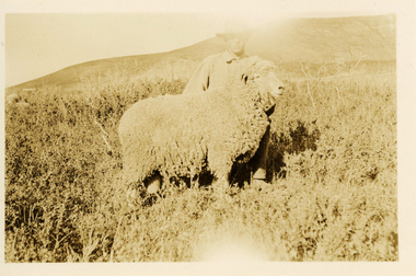
Photograph - 'Harvey' Ram at Neilson's Ranch, J W Allen, 1928-1929
... , Quebec, Sainte-Anne-de-la-Pocatière and St Lawrence River...-Pocatière and St Lawrence River. Properties depicted include Kenton ...This photograph was found loose in the second of three albums compiled and owned by J W Allen, Secretary of New South Wales Grazier's, and is associated with the New South Wales Graziers Association world tour of sheep 1928-1929. The album contains photographs of travel, sheep, farms, stations, people and landscapes from around the world. Locations include Kenya, Kinangop, Naivasha, Elementeita, Lake Nakuru, Njoro, Namibia, Otjihavera, Mt Kenya, Isiolo, Yemen, Aden, Suez, River Jordan, Jerusalem, Hebron, Bethlehem, Beersheba, Galilee, Lake Tiberias, Mt Hermon, Canada, Mt Robson, Fraser River Canyon, British Columbia, Merrit, Canford, Alberta, Cardston, Pekisko Creek, Turner Valley, Calgary, Saskatoon, Manitoba, Winnipeg, Portage la Prairie, Niagara Falls, Quebec, Sainte-Anne-de-la-Pocatière and St Lawrence River. Properties depicted include Kenton Estates, Kekopey Ranch, Soysambu Ranch, Larmudiac, SX Ranch, Neilson's Ranch, EP Ranch and CX Ranch. The album was found in a clean out at the Great Southern Agricultural Research Institute and donated to the National Wool Museum, along with other related material such as photographs, glass lantern slides and ephemera.Black and white image showing a man and a sheep in the foreground with mountains in the background.Back: [handwritten] Harvey ram / at Neilson’s / Harvey / Neilson’s ranch [printed] A 40world tour, sheep, graziers, photograph, canada, agriculture, cardtson, alberta -
 National Wool Museum
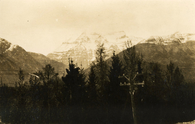
Photograph - Mount Robson, J W Allen, 1928-1929
... , Quebec, Sainte-Anne-de-la-Pocatière and St Lawrence River...-Pocatière and St Lawrence River. Properties depicted include Kenton ...This photograph was found loose in the second of three albums compiled and owned by J W Allen, Secretary of New South Wales Grazier's, and is associated with the New South Wales Graziers Association world tour of sheep 1928-1929. The album contains photographs of travel, sheep, farms, stations, people and landscapes from around the world. Locations include Kenya, Kinangop, Naivasha, Elementeita, Lake Nakuru, Njoro, Namibia, Otjihavera, Mt Kenya, Isiolo, Yemen, Aden, Suez, River Jordan, Jerusalem, Hebron, Bethlehem, Beersheba, Galilee, Lake Tiberias, Mt Hermon, Canada, Mt Robson, Fraser River Canyon, British Columbia, Merrit, Canford, Alberta, Cardston, Pekisko Creek, Turner Valley, Calgary, Saskatoon, Manitoba, Winnipeg, Portage la Prairie, Niagara Falls, Quebec, Sainte-Anne-de-la-Pocatière and St Lawrence River. Properties depicted include Kenton Estates, Kekopey Ranch, Soysambu Ranch, Larmudiac, SX Ranch, Neilson's Ranch, EP Ranch and CX Ranch. The album was found in a clean out at the Great Southern Agricultural Research Institute and donated to the National Wool Museum, along with other related material such as photographs, glass lantern slides and ephemera.Black and white image showing trees, power pole and power lines in the foreground and snow covered mountains in the background. world tour, sheep, graziers, photograph, canada, agriculture, british columbia, mount robson, mt robson -
 Flagstaff Hill Maritime Museum and Village
Craft - Scrimshaw, Hero 1870, Late 20th Century
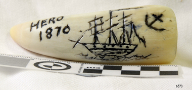
... . By the second week of August, the HMS Hero had sailed up the St... week of August, the HMS Hero had sailed up the St. Lawrence ...Scrimshaw is regarded as early folk art and is associated primarily with whaling that was opened up in the Pacific at the end of the eighteenth century by sailors mainly from American, English and French vessels. As a result, some of the best scrimshaw from Pacific whales can be found in collections in these countries. Even though sailors must have had plenty of spare time between periods of whaling scrimshaw on whale teeth seems a rarity before the 1830s. One reason may have been the high price paid for whale teeth ivory in this period making scrimshaw on teeth popular only after the market was saturated and the price dropped. The earliest identified engraver of whale teeth is the English whaling master Captain J. S. King who was active between 1817 and 1823. There have been six ships called the Hero in the Royal Navy and this ship was the fourth named Hero, it was a screw-propelled 91-gun and second-rate. In the rating system of the British Royal Navy, this term is used to categorise sailing warships, a second-rate was a ship of the line which by the start of the 18th century mounted 90 to 98 guns on three gun decks. Earlier 17th-century second rates had fewer guns and were originally two-deckers or had only partially armed third gun decks. The Hero was launched in 1858 and sold in 1971. On July 1860 the Prince of Wales embarked onboard HMS Hero, Albert Edward Prince of Wales, was the eldest son of Queen Victoria, and the future King Edward VII, at the time he was then nineteen years of age, and on route to Newfoundland, Canada and the United States on his first state tour. He was the first member of the British royal family to visit North America. In 1860 the Queen had intended to pay a visit to Canada however stress prevented her from travelling. The then Prime Minister Lord Palmerston suggested that “Bertie” the prince of Wales could represent the Queen and on July 10th 1860, Bertie boarded HMS Hero for a tour of Canada and the USA. On July 23rd the ship arrived at Terranova. By the second week of August, the HMS Hero had sailed up the St. Lawrence River and anchored at Quebec. The Prince was successful with Canadian society visiting Quebec and Montreal during his stay. He went on to visit the United States following an invitation by President James Buchanan. His American journey was regarded as a great success. President Buchanan wrote to Queen Victoria: "He “Bertie” has faced a very difficult task for a person his age and his behaviour in all this has been that of his age and position. He has shown himself honourable, Frank and affable and he won the respect of the sensible and wise people". The scrimshaw is believed to be a modern reproduction of a typical scrimshaw scene and engraved very crudely onto a synthetic substance. Scrimshaw art carved into non-natural material in the shape of a whale tooth. The line artwork images of a three-masted, fully rigged ship and an anchor are coloured black. Inscription is engraved into tooth.Engraved "Hero 1870"warrnambool, flagstaff-hill, flagstaff-hill-maritime-museum, maritime-museum, shipwreck-coast, flagstaff-hill-maritime-village, scrimshaw, plastic, resin, replica, prince of wales, british navy vessel, whaling, hms hero, reproduction, carving, engraving -
 Melbourne Tram Museum
Book, Victorian Government Information Bureau?, "The Garden City of Australia / Twenty-four views of Melbourne", c1950
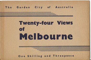
... Victorian Railways 2 Collins St from Spring St (with trams... Bridge, River Yarra ditto 4 St Kilda Rd from Flinders St Station ...Book, brown cover patterned (Deer skin?), titled "The Garden City of Australia / Twenty-four views of Melbourne" with 24 pages (smaller than cover) printed pages stapled inside. Inside front cover is a map of Melbourne, with specific buildings marked, inside rear cover - Where to go in Melbourne, General Information and Sight seeing tours. On rear cover is printer details. Page Photo details by 1 Skyline of the City of Melbourne from Yarra Bank Victorian Railways 2 Collins St from Spring St (with trams) ditto 3 Princes Bridge, River Yarra ditto 4 St Kilda Rd from Flinders St Station ditto 5 St Pauls Cathedral ditto 6 Bourke St Shopping Centre - with double deck buses no details of photographer 7 Elizabeth St - with trams and buses Victorian Railways 8 Swanston St with modern skyscrapers (Collins) ditto 9 Aerial view, city of Melbourne ditto 10 Parliament House ditto 11 Public Library, Museum and Art Gallery ditto 12 St Kilda Rd, Looking towards the City trams 772 and W2 ditto 13 Kings Domain - Pioneer Monument ditto 14 Royal Melbourne Hospital - with back view inset ditto 15 Alexandra Gardens and the Shrine of Remembrance ditto 16 Alexandra Gardens and Government House ditto 17 Captain Cook's House - Fitzroy Gardens ditto 18 Albert Park Lake no details of photographer 19 Melbourne Boys School, MacRobertson's Girls High School and Melbourne Uni - no details of photographer 20 Scene in the Botanical Gardens Victorian Railways 21 Aerial view of St Kilda with Brighton in background Victorian Railways 22 Melbourne Cricket ground, taken during the testimonial match to Sir Donald Bradman - no details 23 Queen Victoria Memorial Hospital and Exhibition Buildings and Aquarium - Victorian Railways 24 Dandenong - Showing Silvan Dam Victorian Railways The testimonial match took place in Melbourne during December 1948 (Reference Sir Donald Bradman Museum). Possibly arranged by the Victorian Government Information Bureau given the number of Victorian Railways photographs.trams, tramways, melbourne, st kilda rd, swanston st, bourke st, victorian railways, flinders st station, gardens -
 Melbourne Tram Museum
Album - Charles Craig - part 1 of 2, 1950s to 1970s
... St CC18 T181 on Maribyrnong Bridge CC19 Ditto at River St... St CC18 T181 on Maribyrnong Bridge CC19 Ditto at River St ...Photo - see pdf file for further information. Number Brief Description CC1 S178 at Elsternwick level crossing track works CC2 Building East Preston Depot 1955 CC3 Camberwell depot – post WW2 – lots of trams and a black cat CC4 W2 584 and SW6 958 northbound – Chapel St and Brighton Road CC5 W2 357 – southbound, Chapel St Brighton Road CC6 Pascoe Vale Road, Raceday working – note the signal CC7 The Preston Workshops - The Argus, post WW2, 223, 647 et al CC8 923 or is it 922 being built at Preston – The Argus photo - CC8A 832 being positioned onto trucks at Preston after an overhaul – Argus Photo – see also CC306 CC9 Footscray depot` CC10 W5 797 in St Kilda Road during track works – 1950s CC11 W2 457 at Kew Post Office CC12 Wellington Parade – W2 432, 492 and 337 – special event CC13 Swan St line up of trams – football? Or other special event – Sinclair’s bus on the right side. CC14 W2 630 being washed at a depot – The Argus photo CC15 Royal Park line at Flemington Road – W2 355 and W5 786 CC16 Nicholson St track construction from a tram cab CC17 T181 on tour at Gordon St CC18 T181 on Maribyrnong Bridge CC19 Ditto at River St just off bridge CC20 As for CC18 CC21 At Raleigh Rd CC22 T181 at Footscray depot CC23 Track construction, Nicholson, just north of Gertrude CC24 Commissioning overhead Bourke St tram 988 CC25 Queens Parade – 997 and 994 CC26 Swapping trolley wheel to skid – commissioning CC27 Track construction in Gertrude St CC28 985 in Queens Parade running special CC29 997 in Queens Parade CC30 1033 at North Fitzroy – AETA Special CC31 Bourke St at Elizabeth St – has passengers on board CC32 W6 985, 996 Queens Parade, Mk 3 bus 333 CC33 As above CC34 Showing construction at Nicholson & Gertrude – Bourke St CC35 W2 223 on Burnley temporary bridge – VR track expansion CC36 W5 823 – ditto CC37 Tram on old bridge prior to removal CC38 W2 433 on temporary bridge with new bridge beams and old track CC39 Looking down showing temporary single track – Swan St CC40 Tait train passing under tram bridge CC41 SW6 on single line – off loading CC42 W2 547 at City Road Junction CC43 City Road Jtn – 1969 – 596 and 771 CC44 City Road Jtn – 1969 – 596 and 771 (same as CC45 438 in Flinders St CC46 355 somewhere CC47 552 somewhere CC47A 364 at Preston Workshops? CC48 W2 334 on Traverser – Preston Workshops CC49 Wellington pade – large line up of trams, c1950 925, and 611 CC50 W2 493 Franklin st – advertising for Savings Certificates CC51 Possibly 551 with advertising for fund raising for Blind institute CC52 249 at Hawthorn – Riversdale Junction – with a Tally Ho and Village Fair Aux. board CC53 MMTB Postcard of 511 CC54 Wattle Park terminus with Single line warning sign CC55 Wattle Park Duplication CC56 36 at Domain Junction – 833 CC57 36 at Domain Junction CC58 36 at Domain Junction with 810 and 833 CC59 36 in Swanston by Flinders St Station CC60 36 in Spencer St at A’Beckett CC61 36 crossing Collins St CC62 36 crossing Collins St CC63 36 northbound in St Kilda Road with Shrine in background CC64 36 northbound in Swanston St at Flinders St CC65 Postcard – Ballarat 36 in Domain Road CC66 Postcard - Stampshow – Hawthorn Horse tram CC67 Postcard - Stampshow – Peace cable tram CC68 Postcard - 1041 and cable car set 1 at Preston CC69 Postcard - Colins & Elizabeth – greetings from old Melbourne CC70 Postcard - Cable car set at Preston CC71 Postcard - Twentyman’s cable cars CC72 Postcard - Nu-color-vue – horse tram 256 CC73 Cable car set – Market & Flinders CC74 Cable trams at Twentymans’ in their shed CC75 Cable tram track at Bourke & Spencer prior to removal CC76 Cable tram bogie at Preston Workshops – used as a dolly CC77 Cable trams at Twentymans’ CC78 Postcard - Valentines – Bourke looking west from Swanston CC79 Postcard - Rose 3938 – Bourke at Swanston – the Leviathan building CC80 Postcard - Valentines – Elizabeth St looking south from Collins – No. 19 CC81 Postcard - Rose P4765 – Bourke St Melbourne CC82 Postcard - Rose 4090 – cable tram passing Parliament house CC83 Postcard - Valentines – GPO Elizabeth St CC84 Interior of cable trailer with clothing on a set CC85 Elizabeth St looking north CC86 Cigarette card - Collins St No. 41- WD HO Wills CC87 Postcard - Rialto building with cable set CC88 Postcard - Valentines - Swanston at Flinders looking north CC89 CC90 Q 150 Hanna St – dated on rear CC91 176 turning – photo ex Alan Jungworth CC92 161 on Princes Bridge – minimum fare 4d sign and Inspector CC93 459 at Point Ormond CC94 158 at Gordon St – side on view CC95 X 217 in Swanston St CC96 X 217 in Swanston St with an East Brighton destination CC97 T177 CC98 T177 Peel St – no destination roll – being transferred? CC99 X1 462 in Glenhuntly Road to Point Ormond CC100 X1 462 in Glenhuntly Road to Elsternwick Rly Station CC101 X1 462 in Glenhuntly Road to Point Ormond CC102 Q 150 Hanna St CC103 190 at Camberwell Depot CC104 T182 at Footscray CC105 X1 466 and W2 at Footscray CC106 190 at Camberwell Depot CC107 X1 467 Barkly St Footscray CC108 X2 679 turning into William St from La Trobe St CC109 X2 677 Glenhuntly Road with Point Ormond Destination CC110 Postcard T180 CC111 Postcard format – X1 467 on a truck – see also CC178 CC112 Postcard format – X1 467 at Wantirna South CC113 Q200 and SW6 896 at Thornbury – has labels on rear CC114 T177, Ballarat Road – has labels on rear CC115 T178 at Point Ormond CC116 Postcard X1 465 and 466 CC117 Postcard – X2 676 CC118 Postcard – TMSV X2 217 CC119 810 on temporary bridging – 24-12-67 CC120 W2 575 – Queens Parade junction in, still temporary bridging, substation under construction CC121 Forming Queens Parade Junction base slab CC122 W2 596 prior to tramway works – all tracks still in position CC123 It’s a mass of reinforcing – bridging being formed CC124 Looking north with substation being built CC125 Looking east with some rather tight curves, Wellington St still in use CC126 SW6 958 ex Wellington St with all tracks and signal box and buildings. CC127 Victoria Pde at Gisborne looking east – at least 4 cars CC128 SW6 893? With dash canopy lights and SW6 862 and a man with a newspaper CC129 SW6 894 on the S curves, with tram in Wellington St CC130 Similar photo CC131 W2 564 turning into Wellington St – the concrete tracks are not that old CC132 W2 552 running out of Wellington St CC133 W5 732 from Fitzroy St into St Kilda Road with next iteration in position – very wonky CC134 W5 764 turning into Fitzroy St CC135 SW6 947 turning from Wellington St CC136 W2 586 running out of High St CC137 W2 500 turning into Wellington St CC138 W2 543 in Wellington St inbound CC139 L103 with St Kilda Junction destination, and a tower truck on right CC140 Workmen – new track in Queensway in use CC141 Ditto CC142 L103 in Queensway, and another car in bound CC143 Looking east along Wellington St which has been taken out of use. Also a MMTB Roller CC144 W5 824 and a W2 and all types of wobbly temporary track CC145 W2 354 to High St CC146 Sw6 947 on the S bends CC147 W2 500 looking north – tram on the S bends CC148 SW6 896 leaving the S bend CC149 W2 357 and a MMTB City bus with trees/gardens on the side CC150 W5 817 Elliot Ave – see also CC302 CC151 W2 552 – note the large trolley bridge CC152 W2 550 at depot or workshops CC153 1B truck CC154 SW2 432 CC155 W2 155 at Glenhuntly CC156 SW6 937 on AETA tour? CC157 X2 677 on Footscray service – Ballarat Rd? CC158 W2 641 – High St Kew? CC159 SW6 847 – Power St Hawthorn CC160 Simpson St – big line up CC161 W2 546 truck No. 1? CC162 W2s at Glenhuntly depot CC163 No. 15 truck under 899 CC164 206 and other junk at Preston Workshops CC165 W in Swanston St Melbourne – Rose series card CC166 Y1 613 Batman Ave?? or William St at Collins CC167 Tram plans CC168 X 217 Swanston St – see also 95 and 96 CC169 217 in Swanston St – same as 95 CC169A 192 in St Kilda Road at Princes bridge CC170 192 in St Kilda Road at Princes bridge CC171 Bendigo 3 arriving Malvern depot – being unloaded CC172 Ditto CC173 T180 at a depot CC174 X1 463 wheel set CC175 C30 – dog car side view – close up CC176 C30 dog car CC177 206 and 30 at Preston Workshops CC178 X1 467 on a truck – see CC111 also CC179 42 CC180 42 at a depot, no destination box CC181 W2 556 1A type truck CC182 Flinders St Station – Rose Series CC183 W7 1035 Spring – Nicholson St CC184 W7 1022 MMTB Post Card CC185 Adelaide 178 – has on rear – R. Lilburn 4/82 CC186 Adelaide 175 – has on rear – R. Lilburn 4/82 CC187 Y1 610 on AETA tour CC188 Y1 610 on AETA tour with large group – Point Ormond CC189 AETA display – has GH55-32 in pencil on rear CC190 AETA display – has GH55-29 in pencil on rear CC191 Y1 610 on AETA tour with large group – Point Ormond CC192 VR 53 at Footscray CC193 VR cars 40 and 34 at Elwood wash dock CC194 W7 1024 as the 1970 Christmas tram CC195 Geelong – loading a set of 22E trucks CC196 Geelong 10 and 23 running an AETA special CC197 Geelong – AETA special CC198 Geelong 7 at Junction CC199 Geelong 10, in the city CC200 Geelong 33 with Belmont destination CC201 Geelong 15 Eastern Park destination 29-3-1948 CC202 Geelong 23 at Railway Station – 29-3-1948 CC203 Geelong 23 at Railway Station – 29-3-1948 CC204 Geelong – loading a bogie tram CC205 Geelong – loading a bogie tram CC206 Geelong 40 – loaded on truck CC207 Geelong 40 – on jacks CC208 Geelong 40 on jacks – 19 behind CC209 Geelong 38 with two workers on either side CC210 – 214 Australian Historic Tramways stamp folder and set CC215 Bendigo 17 at depot – has dup JBS on rear CC216 Bendigo 20, 29 bogie and straight sill car at Charing Cross CC217 Bendigo one man bogie Pall Mall CC218 Bendigo – Bogie 23, other cars and welding truck at depot CC219 Bendigo 7 with Quarry Hill destination CC220 Bendigo 21 with Lake Weerona destination CC221 ESCo 18 Ballarat CC222 Ballarat bogie 22 on AETA special CC223 Ditto CC224 Ballarat 34 at Stones Corner – R Lilburn CC225 Ballarat 15 in Bridge St – R Lilburn CC226 Ballarat 40 at Gardens – R Lilburn CC227 Ballarat 37 running out of depot – R Lilburn CC228 Postcard – Valentines – Sturt St with loaded horse tram trailer CC229 AETA Geelong tram tour ticket – 29-3-1948 CC230 Postcard – Geelong – Valentine 2114 – T&G building CC231 Postcard – PMTT ! – High St Malvern CC232 Postcard – Empire – Glenferrie Road, Malvern at Wattletree Rd CC233 Postcard Y469, MMTB CC234 Postcard Z2 Spring St CC235 Postcard – Z1 MMTB CC236 Postcard – Stamp Show W1 431 CC237 Postcard – Stamp show B2005 CC238 Postcard – Stamp show W6 982 CC239 Postcard – Valentines 1264 – Johnstone Park with tram in distance CC240 Postcard – Rose 10711 – Swanston and Lonsdale – Hospital and W232 CC241 Postcard – Rose 4827 – Fitzroy St St Kilda W2 362 and 548 CC242 Postcard – Valentines – 939 – St Kilda War Memorial, W and a R? CC243 Postcard – Valentines – 572 – St Kilda War Memorial, W 413 and 140? CC244 Postcard – Valentines – 938 – Uper and Lower Esplanade – L 104 CC245 Postcard – St Kilda Rd at Princes Bridge Y1 and W CC246 Postcard – Biscay BG82 – W5 814 - CC247 Postcard – Biscay 796112 – Bourke St looking west CC248 Postcard – Biscay 796109 – Bourke St looking east CC249 Postcard – Biscay 2AUS58 – Z5 Bourke St CC250 Postcard – Biscay BG 249 – Swanston St CC251 Postcard – National View – St Kilda Rd – shrine and Prince Henrys W2 405 CC252 Postcard – Nu color vue – 11 ML 156 – St Kilda Rd CC253 Postcard – Nu color vue – 11 ML 153 – Swanston St CC254 Postcard – Nu Color vue – Collins St 442 CC255 Postcard – Pitt card – Adelaide – H 364 at Victoria St CC256 Postcard – SPER L/P 154 CC257 Postcard – BTMS – 550 CC258 Postcard – SPER – Brisbane 295 CC259 Adelaide 131 at Burnside – has R Lilburn on card, c1911 CC260 Adelaide 194 CC261 Adelaide 235, with two crew, The News photo CC262 Rockhampton, outside post office – has source of photo details CC263 Sydney – 2086 and 2062 arriving Circular Quay CC264 Sydney – P class – Pitt St? CC265 Sydney – 1610 at Circular Quay CC266 Brisbane 99 and 468 CC267 Sydney with bridge behind CC268 Steam tram Paramatta Park – 103 CC269 Sydney – Museum Station =- Elizabeth St CC270 Sydney – weed burner 137S at a loop Demonstrates the work of Charles Craig in photography and collection of prints.Assembled album in a black presentation folder of 270 photographs from the Charles Craig Collection - 86 sleeves - part 1 of 2. All photographs have been scanned and placed on the Museum's G drive. A list of all photographs with details where possible has been compiled. Victorian Provincial, Launceston, Hobart and Sydney tram photos have been transferred to other Museums, image files retained.melbourne, tramways, tramcars, trams, charles craig, st kilda junction, trackworks -
 Camperdown & District Historical Society
Photograph - James Dawson, Thomas Rodger, c1881
James Dawson (1806-1900), pastoralist, friend to First Nations people, environmentalist, patron of the Arts and author of "Australian Aborigines" (1881). Dawson came from Bonnytoun, near Linlithgow, Scotland and arrived in Melbourne with his wife, Joan Alexander Park, on 2 May 1840. They made their first home in the colony farming in Port Phillip, near Anderson's Creek on the Yarra River, where their daughter, Isabella was born in 1842, then from 1844, moved to 'Kangatong' station on the Moyne River, east of Macarthur. In 1866 the Dawsons left the Port Fairy district and lived in various residences in Melbourne. By 1868 the family had settled in Camperdown at 'Wuurong', on the banks of Lake Bullen Merri. Unlike most people at the time, Dawson and his daughter shared a deep interest in, and respect for First Nations people. In 1876 James Dawson was appointed local Guardian of the Aborigines in the Camperdown district. He was a prolific letter writer and an early advocate for indigenous rights and was dedicated to exposing injustice and the maltreatment of First Nations people. He had befriended Wombeetch Puyuun (Camperdown George) who was the last of the local Djargurd Wurrung living on Country when he died in February 1883. In 1885 James Dawson erected the Wombeetch Puyuun Monument at Camperdown Cemetery in his memory. His friend's remains were reburied at the foot of the obelisk and the two dates, 1840-1883, mark the 43 years it took for European settlement to displace the Djargurd Wurrung from the Camperdown District.Sepia photograph of an elderly James Dawson taken in Scotland. Front: T. Rodger St. ANDREWS N.B. Back: THOMAS RODGER Photographer ST. ANDREWS ETABLISHED 1849cdhs, isabella dawson, camperdown cemetery, djargurdwurrung, cdhsfirstnations -
 Camperdown & District Historical Society
Book - The James Dawson Scrapbook, c1881
James Dawson (1806-1900), pastoralist, friend to First Nations people, environmentalist, patron of the Arts and author of "Australian Aborigines" (1881). Dawson came from Bonnytoun, near Linlithgow, Scotland and arrived in Melbourne with his wife, Joan Alexander Park, on 2 May 1840. They made their first home in the colony farming in Port Phillip, near Anderson's Creek on the Yarra River, where their daughter, Isabella was born in 1842, then from 1844, moved to 'Kangatong' station on the Moyne River, east of Macarthur. In 1866 the Dawsons left the Port Fairy district and lived in various residences in Melbourne. By 1868 the family had settled in Camperdown at 'Wuurong', on the banks of Lake Bullen Merri. Unlike most people at the time, Dawson and his daughter shared a deep interest in, and respect for First Nations people. In 1876 James Dawson was appointed local Guardian of the Aborigines in the Camperdown district. He was a prolific letter writer and an early advocate for indigenous rights and was dedicated to exposing injustice and the maltreatment of First Nations people. He had befriended Wombeetch Puyuun (Camperdown George) who was the last of the local Djargurd Wurrung living on Country when he died in February 1883. In 1885 James Dawson erected the Wombeetch Puyuun Monument at Camperdown Cemetery in his memory. His friend's remains were reburied at the foot of the obelisk and the two dates, 1840-1883, mark the 43 years it took for European settlement to displace the Djargurd Wurrung from the Camperdown District.The James Dawson Scrapbookcdhs, isabella dawson, camperdown cemetery, djargurdwurrung, cdhsfirstnations -
 Camperdown & District Historical Society
Photograph - James and Joan Dawson, studio photograph, c1878
James Dawson (1806-1900), pastoralist, friend to First Nations people, environmentalist, patron of the Arts and author of "Australian Aborigines" (1881). He married Joan Alexander Park in 1877. Joan was the niece of the famous African explorer, Mungo Park. James Dawson came from Bonnytoun, near Linlithgow, Scotland and arrived in Melbourne with his wife on 2 May 1840. They made their first home in the colony farming in Port Phillip, near Anderson's Creek on the Yarra River, where their daughter, Isabella was born in 1842, then from 1844, moved to 'Kangatong' station on the Moyne River, east of Macarthur. In 1866 the Dawsons left the Port Fairy district and lived in various residences in Melbourne. By 1868 the family had settled in Camperdown at 'Wuurong', on the banks of Lake Bullen Merri. Unlike most people at the time, the Dawson's shared a deep interest in, and respect for First Nations people. In 1876 James Dawson was appointed local Guardian of the Aborigines in the Camperdown district. He was a prolific letter writer and an early advocate for indigenous rights and was dedicated to exposing injustice and the maltreatment of First Nations people. He had befriended Wombeetch Puyuun (Camperdown George) who was the last of the local Djargurd Wurrung living on Country when he died in February 1883. In 1885 James Dawson erected the Wombeetch Puyuun Monument at Camperdown Cemetery in his memory. His friend's remains were reburied at the foot of the obelisk and the two dates, 1840-1883, mark the 43 years it took for European settlement to displace the Djargurd Wurrung from the Camperdown District.Studio portrait of James and Joan Dawson taken in Australia. cdhs, isabella dawson, camperdown cemetery, djargurdwurrung, cdhsfirstnations -
 Camperdown & District Historical Society
Photograph - James Dawson, c1878
James Dawson (1806-1900), pastoralist, friend to First Nations people, environmentalist, patron of the Arts and author of "Australian Aborigines" (1881). Dawson came from Bonnytoun, near Linlithgow, Scotland and arrived in Melbourne with his wife, Joan Alexander Park, on 2 May 1840. They made their first home in the colony farming in Port Phillip, near Anderson's Creek on the Yarra River, where their daughter, Isabella was born in 1842, then from 1844, moved to 'Kangatong' station on the Moyne River, east of Macarthur. In 1866 the Dawsons left the Port Fairy district and lived in various residences in Melbourne. By 1868 the family had settled in Camperdown at 'Wuurong', on the banks of Lake Bullen Merri. Unlike most people at the time, Dawson and his daughter shared a deep interest in, and respect for First Nations people. In 1876 James Dawson was appointed local Guardian of the Aborigines in the Camperdown district. He was a prolific letter writer and an early advocate for indigenous rights and was dedicated to exposing injustice and the maltreatment of First Nations people. He had befriended Wombeetch Puyuun (Camperdown George) who was the last of the local Djargurd Wurrung living on Country when he died in February 1883. In 1885 James Dawson erected the Wombeetch Puyuun Monument at Camperdown Cemetery in his memory. His friend's remains were reburied at the foot of the obelisk and the two dates, 1840-1883, mark the 43 years it took for European settlement to displace the Djargurd Wurrung from the Camperdown District.Side portrait of an elderly James Dawson. cdhs, isabella dawson, camperdown cemetery, djargurdwurrung, cdhsfirstnations -
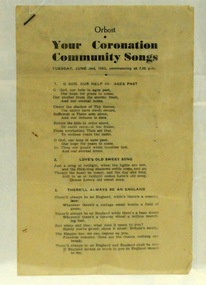 Orbost & District Historical Society
booklet, Your Coronation Community Songs, 1953
This booklet was printed by the Snowy River Mail newspaper to be used at a community event celebrating the Coronation of Her Majesty Queen Elizabeth II in the Abbey Church of St. Peter, Westminster, on Tuesday, the second day of June, 1953. The coronation of Queen Elizabeth 11 was a significant event in 1953. This booklet is representative of a community event.A booklet containing word of songs for a community celebration of the coronation of Queen Elizabeth 11. It is titled "Your Coronation Community Songs". For Tuesday June 2 1953 at 7.45pm.coronation booklet-songs souvenir -
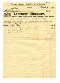 Orbost & District Historical Society
account, March 31st 1911
Lancelot Herbert came to Orbost in 1886, taking up a partnership with local store-owner George Temple. After Mr Temple’s death in 1891, Lancelot took over the store and progressively developed Herberts Snowy River Stores which grew into a department store of several shops along Nicholson St. He also had small shops at Cann River, Noorinbee and Genoa which were run by members of his family, as well as a carrying business and fuel outlets. Lancelot died on 2/6/1911 and his wife Martha [died 1945] are buried in a joint grave in Orbost Cemetery. (info. Noreen and Lindsay Thomson) Robert Pullar Cameron was a Shire Councillor for many years. He married Penuel Hossack and had a family of James, Flora, Penuel and Alex.This item is associated with a well-known Orbost business which started in 1888 and finally closed in c.1970. it is an example of book-keeping in the early 20th century and is a useful research tool.A white paper account with black print and red lines. Hand-written from Lancelot Herbert of Snowy River Stores to R.P. Cameron.herbert-lancelot snowy-river-stores cameron-robert-pullar