Showing 920 items matching "road guide"
-
 Bendigo Historical Society Inc.
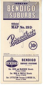
Map - Three Road Maps of Bendigo, 1962
... of a continuous publishing programme by Broadbent's Official Road Guides... publishing programme by Broadbent's Official Road Guides Co. history ...George Robert Broadbent (1863-1947), cyclist and map publisher, was born on 3 November 1863 at Ashby near Geelong, Victoria, son of George Adam Broadbent, Lancashire-born draper, and his wife Elizabeth, née Ruffhead. When the family moved to North Melbourne Broadbent attended the Errol Street school, followed his father's trade, and became an early cycling and cycle-racing enthusiast. At various times Broadbent held most Victorian and Australian road records, and two of his performances on solid tyres—203 miles (327 km) in 24 hours on a penny farthing, and 100 miles (161 km) in 6 hours 20 minutes on a 'safety' bicycle—were never bettered. He established records for all distances between 130 and 220 miles (209 and 354 km), and for all times between 8 and 12 hours, at the Exhibition Grounds track in May 1894, and road records for 50 and 100 miles (80 and 161 km) in October 1896. The Australian Cyclist acknowledged him 'the finest road rider that Australia has ever produced'. A foundation councillor of the League of Victorian Wheelmen in October 1893, Broadbent contested the first Warrnambool-Melbourne race in 1895, and was active in the Good Roads Movement. Next year he issued a road map of Victoria, 'prepared … after some sixteen years riding and touring in all parts of the Colony', which indicated general topography, distances, and roads classified as 'good', 'fair' or 'ridden with difficulty'. It was to become Victoria's standard map, and the basis of a continuous publishing programme by Broadbent's Official Road Guides Co.Three Road Maps of Bendigo, Bendigo and Suburbs, Bendigo and Eaglehawk. Two fold out maps printed in colour and produced by Broadbent's Road Maps Pty. Ltd. 475 Collins Street Melbourne. One map printed by Bolton's Bendigo.history, bolton's, bendio broadbent maps -
 Warrnambool and District Historical Society Inc.
Booklet - Warrnambool Visitor's Handbooks 1979-2024, Collett, Bain and Gaspar, Printers, 1979-2014
... Ocean Road Official Visitor Guide; It's a wonderful Warrnambool... Handbook [.8] Warrnambool Great Ocean Road Official Visitor Guide ...This is a collection of eight Warrnambool Visitor handbooks produced between 1979 and 2014 by the City of Warrnambool Tourist Information Centre. They contain maps of Warrnambool, lists of services, accommodation and tourist attractions as well as many advertisements for local businesses.These handbooks give a useful snapshot of businesses and tourist attractions in Warrnambool for each of the years covered. (1979, 1980, 1986, 1990, 1993, 1994, 1995, 2014)[.1a] A 48 page booklet with white pages and blue printing. The front cover has a coloured photograph of Flagstaff Hill with boats on a man made lake in the foreground looking across Lake Pertobe toward South Warrnambool. [.1b] A coloured bifold brochure. The front cover has a fisherman on a cray-boat holding a crayfish in the lower section. The top quarter has a blue back ground with white printing. The rear cover is red and has small photos of the Hopkins River and the Framlingham Forest. [.2] A 48 page booklet with white pages and black printing. The front cover is white with black writing on the left hand side and a colour photograph of the Loch Ard peacock. The Warrnambool Premier Town stylised logo of seven Norfollk pines above blue waves is in the top right hand corner. There is a blank ink Warrnambool Library stamp underneath the logo. The rear cover has photographs of The Twelve Apostles and the Hopkins Falls and the Premier Town Logo [.3] A 40 page booklet with mainly black printing on white paper. There are three fold out maps of Warrnambool and the surrounding district. The glossy cover has a black background with a colour photograph of the Twelve Apostles taken at sunset. The rear cover has three small of Proudfoot's boathouse on the Hopkins River, Flagstaff Hill, and the main beach area. The front cover has black writing inside to peach coloured rectangles. The inside rear cover has a fold out coloured tour map of Western Victoria. [.4] A 40 page booklet printed on glossy white paper with coloured photographs and black and red printing. The front cover has a photograph of The Twelve Apostles surrounded by a white border. There is red writing in the upper border. There is a sandy coloured writing superimposed across the bottom of the photograph and a Victoria's Shipwreck Coast logo in the bottom right hand corner. [.5] A 44 page booklet printed on white paper with black printing. The cream coloured cover has a pale red rectangle with blue writing on the right hand facing edge and includes two stylised Norfolk pines and with waves underneath. There is is an intersecting blue rectangle with cream printing. [.6] A 48 page booklet printed on white paper with black printing. The cover is brown with a cream vertical strip containing black writing on the right hand side. There is a stylised map from Geelong to Mount Gambier showing the Great Ocean Road across the cover. [.7] A 48 page booklet printed on white paper with black print. The glossy colour cover has a photograph of a Southern Right whale fluke. There is white printing on a the blue background of the sky and sea. The bottom left hand side of the front cover has a Tourism Victoria logo made of jigsaw puzzle pieces. The back cover has a stylised coloured map of The Great Ocean Road located in a white rectangle at the top of the page. Within the rectangle is a small map of Australia locating Victoria and the part of Victoria covered by the map. [.8] A 64 page A5 coloured booklet printed on white pages with black print. The white front cover has black and grey print with a colour photograph of two people holding coffee cups watching four race horses being exercised on the beach and in the water of Lady Bay in the early morning. The bottom right hand corner has a Tourism Victoria logo. The rear cover has a mainly blue back ground with a pink orange and green colour splats contains words advertising the 2015 Fun 4 Kids Festival [.1a] Warrnambool The Heart of Victoria's Great Southwest Visitor's Handbook [.1b] Warrnambool City for all seasons; The Heart of Victoria's Great Southwest [.2] Warrnambool visitor's handbook Warrnambool Premier Town 1979-1982 [.3] Warrnambool Handbook Victoria [.4] Warrnambool The Shipwreck Coast [.5] Welcome to Warrnambool Warrnambool Visitors Handbook 1993-1994 [.6] Welcome to Warrnambool Visitors Handbook 1994-95 Rear cover: Warrnambool Centre of Victoria's Shipwreck Coast on Australia's Great Ocean Road [.7] Warrnambool Shipwreck Coast - Great Ocean Road; You'll love every piece of Victoria; Visitors Handbook [.8] Warrnambool Great Ocean Road Official Visitor Guide; It's a wonderful Warrnambool; You'll love every piece of Victoria visitvictoria.com. Rear Cover Live entertainment.Workshops.Creativity.Action 28 June - 5 July 2015 Australia's Best Children's Festival F4K The ultimate winter school holiday adventure Fun 4 kids festival Warrnambool For more information visit Fun4kids.com.au Warrnambool great Ocean Road Victoriawarrnambool, visitor handbooks, tourist information guides, warrnambool maps -
 Orbost & District Historical Society
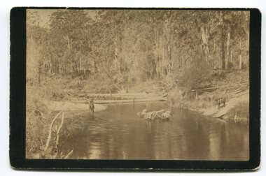
black and white photograph, late 19th - early 20th century
In the late 1800's early 1900's transporting goods by road was difficult and at times impossible because roads as thoroughfares did not exist.The means of travelling along the roads in the 1800's was by bullock wagon, horse pulled dray, pack horse or simply by foot. This is a pictorial record of transport in the mid 18th - early 19th century. Pack horses were vital for the delivery of goods, responding to emergencies as they could travel in country inaccessible to larger horse - drawn carts or wagons.A black / white photograph on a black buff card. It is of a group of pack horses being guided across a waterway with a man on horseback on either side of the river.transport pack-horses -
 Flagstaff Hill Maritime Museum and Village
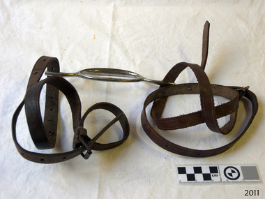
Equipment - Bridle Bit and Headstall, Early 1900s
The leather headstall is connected to the metal bit are used in conjunction with a set of leather reins to guide and steer a horse or other similar animal. Made in Melbourne in 1900.The horse bridle and headstall were used in Warrnambool in the early 20th century. Bridle bit and headstall; horizontal metal oval shaped bit with a narrow rod each end that finishes in a narrow loop. Adjustable leather straps with holes are threaded through the narrow metal loops.flagstaff hill, flagstaff hill maritime museum and village, warrnambool, maritime museum, maritime village, great ocean road, shipwreck coast, horse husbandry, horse equipment, horse riding, 1900, melbourne, headstall, bridle, horse headgear, riding gear, horsemanship, equestrian equipment, headgear -
 Flagstaff Hill Maritime Museum and Village
Book, The New Guide to Carpentry General Framing and Joinery
The New Guide to Carpentry General Framing and Joinery by Robert Scott ed Burn Publisher John G Murdoch flagstaff hill, warrnambool, shipwrecked-coast, flagstaff-hill, flagstaff-hill-maritime-museum, maritime-museum, shipwreck-coast, flagstaff-hill-maritime-village, book, the new guide to carpentry general framing and joinery -
 Flagstaff Hill Maritime Museum and Village
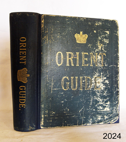
Book, Orient Guide
Orient Guide Editor - W J Loftie Publisher Sampson Low, Marston, Searle & Rivington flagstaff hill, warrnambool, shipwrecked-coast, flagstaff-hill, flagstaff-hill-maritime-museum, maritime-museum, shipwreck-coast, flagstaff-hill-maritime-village, book, orient guide -
 Flagstaff Hill Maritime Museum and Village
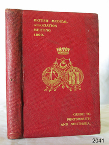
Book, Guide to Portsmouth Southsea and Neighbourhood
Guide to Portsmouth Southsea and Neighbourhood by H T Lilley Publisher Charpentier & Co Date 1899 flagstaff hill, warrnambool, shipwrecked-coast, flagstaff-hill, flagstaff-hill-maritime-museum, maritime-museum, shipwreck-coast, flagstaff-hill-maritime-village, guide to portsmouth southsea and neighbourhood, book, h t lilley -
 Ringwood and District Historical Society
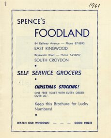
Programme, Ringwood East Giant Community Fair in 1961
Giant Community Fair organised by the Ringwood East Chamber of Commerce to be held in the Drill Hall Grounds Dublin Road Ringwood East on Saturday December 2nd 1961. All proceeds to aid Local Charities which include: Ringwood East Red Cross Company, Ringwood East Pre-school, Warrawong Holiday Kindergarten, Boy Scouts, Girl Guides, Maroondah Pre-School Centre, Eastwood Mothers Club, Ringwood East Mothers Club, St. Francis School Mothers Club, Ringwood East Tennis Club, Legacy, Yarra Valley, Police & Citizens Youth Club, Ladies Guilds of District Churches. Events include Dog Competition, Marching Girls, Boxing and Judo Display, Police Exhibition, Cake Stalls and a visit from Father Christmas. Advertising including Spences Foodland, Harry Wiltshire's East Ringwood Hardware, Whytes, Buchanan's Newsagency, Ian E Russell, Barry Hall Chemist, Orleans' Florist - Pet Shop, Sunrise Secretarial Service, Eastwood Cycle & Sports Store, Jenny & John Gift Shop, J.W.F. Sloan Butcher, Bill Patterson Motors, Shir-Vonne Beauty Salon, Eastwood Cake Shop, H.E. & M.D. Burridge, Kellettskornor and Joan's Handy Bar. -
 Phillip Island and District Historical Society Inc.
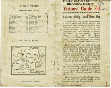
Booklet, Authentic Phillip Island Road Map, Pre 1960
... Visitors' Guide 6d Authentic Phillip Island Road Map Small cream ...Tourist brochure printed by the Phillip Island Printers pre 1960HistoricalSmall cream coloured brochure with details of accommodation, transport and animals. Inside is a map of the Island with numbered points of interest. There is also a plan of Cowes and drawings of animals.Visitors' Guide 6d Authentic Phillip Island Road Maptourist brochure, road map -
 Ringwood and District Historical Society
Directories, Scout Association, Ringwood and Heathmont Scouts and Guides directory 1978-9, 1978-1979
Directory 1978-1979. Copies 2. Typed listing of Ringwood and Heathmont scouts and guides. pp.6. Buff coloured paper. -
Ringwood and District Historical Society
Booklets, Gratton Lilydale, Ringwood Cricket Club: collection of booklets with grades from 1924-25 season to 1966-67, c. 1924 - 1967
Annual guides with supporting clubs and office bearers named.Small booklets giving Ringwood Cricket Club grades from 1924-25 season to 1966-67 season. Some years with 2 copies. Various colours. Qty 24. -
Ringwood and District Historical Society
Badge, Girl Guides badge North Ringwood District 1961
owner unknownCircular metal badge, black background, Guide trefoil and printing in gold.North Ringwood District Girl Guides 1961 -
 Ringwood and District Historical Society
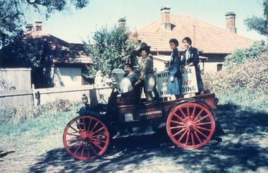
Photographs, Ringwood Scout Fete at the Old Ringwood Oval 14-Mar-1958 including lolly shop, floats and pipe band, 14-Mar-58
3224_001 - Scout Fete on Ringwood Oval 4March1953 - Norm Pavey milk cart 3224_002 - Scout Fete on Ringwood Oval 4March1953 - International Harvester float arriving 3224_003 - Scout Fete on Ringwood Oval 4March1953 - a stall 3224_004 - Scout Fete on Ringwood Oval 4March1953 - Scout float 3224_005 - Scout Fete on Ringwood Oval 4March1953 - Girl Guide's float 3224_006 - Scout Fete on Ringwood Oval 4March1953 - Ringwood Banjo Club's float 3224_007 - Scout Fete on Ringwood Oval 4March1953 - Scout stall 3224_008 - Scout Fete on Ringwood Oval 4March1953 - Merry Go Round 3224_009 - Scout Fete on Ringwood Oval 4March1953 - Norm Pavey milk cart 3224_010 - Scout Fete on Ringwood Oval 4March1953 - Margaret McCall at lolly stall 3224_011 - Scout Fete on Ringwood Oval 4March1953 - Box Hill Ladies Pipe Band 3224_012 - Scout Fete on Ringwood Oval 4March1953 - Jack Gray, Hugh McCall, Charles Miller selling fruit 3224_014 - Scout Fete on Ringwood Oval 4March1953 - Ellie Pullin selling lollies +Additional Keywords: Pullen, Ellie / Pavey, Norm -
Ringwood and District Historical Society
Documents, City of Ringwood, Demographic profile of the City of Ringwood August 1989, 1960/1989/1991
During refurbishment of office in Civic Centre sent to VRDHS by Miranda de Giorgio, Community Liaison Officer 8-Dec-1993.Collection of documents about the City of Ringwood - civic centre.; 1. Demographic profile of the City of Ringwood August 1989.; 2. City of Ringwood - An Information Guide for Students- Nov 1991.; 3. Councillors names and addresses 5-Aug-1991; 4. Civic Centre - New Telephone Numbers; 5. City of Ringwood - Boundary Map; 6. City of Ringwood - 3 folders (2 coloured) 1960 +Additional Keywords: de Giorgio, Miranda -
 Ringwood and District Historical Society
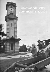
Book, Ringwood City Community Guide (1976-77), 1976
Ringwood Community Guide containing Council editorial, brief history of Ringwood, local Community Services and Business Listings. Also includes a street directory map of Ringwood Municipality, and a 1976-1977 Calendar."First Edition". "Front cover photograph: Memorial Clock Tower erected in 1928."rinx -
 Ringwood and District Historical Society
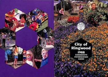
Booklet, City of Ringwood 1988 Community Information Guide, 1988
Community information booklet issued by City of Ringwood for 1988 - covering the facilities and activities of the Ringwood Council and other local organisations and associations. Cover photographs: Front - Floral displays at Clock Tower and a scene at Council nursery; Back - Activities at Ringwood Festival held at Ringwood Lake in April each year.CONTENTS: (page no.) After School Activities Programme 23 Aged Services 21 Bicentennial 15 Building Information 29 By-Laws and Traffic Regulations 31 Caravans/Mobile Homes 31 Chief Executive's Message 10 Children's Services 22 Churches 40 Civic Centre 4 Committees of Council 5 Community Plan 15 Community Services 35 Corporate Management Structure 11 Council Meeting Dates 4 Council Representatives 8 Councillors 6 & 7 Disabled Persons Facilities 42 Dogs 31 Domiciliary Care 24, 25 & 26 Elderly Day Care 44 Elderly Persons Units 29 Emergency Telephone Numbers 53 Employment Opportunities in Ringwood 26 European Wasps 28 Family Day Care 22 Finances 17 Fire Hazards 31 Future Leaders 16 Golf Course 34 Home Handyman Services 25 Home Help 26 Immunisation Programme 27 Incinerators 32 Knaith Road Child Care Centre 22 & 23 Library 30&31 Maternal & Child Health Centre 30 Mayoral Message – Cr. John R. Caffyn 3 Meals on Wheels 24 Members of Parliament 9 Playgroups 33 Pre-Schools 53 Primary Arterial Road Network in Ringwood 13 Rates—New Collection Service 18 & 19 Ringwood Aquatic Centre 14 & 15 Ringwood Bypass Road 12 Ringwood Convention & Performing Arts Centre 33 Ringwood District Centre Structure Plan 12 Rubbish Collection Service 35 & 36 Schools 56 Youth Outreach Worker 20 rinx -
 Ringwood and District Historical Society
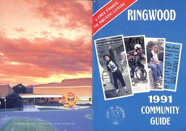
Booklet, City of Ringwood 1991 Community Guide, 1991
Community information booklet issued by City of Ringwood for 1991 - covering the facilities and activities of the Ringwood Council and other local organisations and associations. Includes 2 free passes to Ringwood Aquatic Centre.CONTENTS: (page no.) After School Programme 20 Aged Services 17 Aquatic Centre 12 Aquatic Centre Bonus Vouchers 14 Biological Wasp Control 35 Budget 10 Building Information 28 By-Laws 25 Chief Executive's Message 8 Children's Services 20 Citizenship 24 Civic Centre (i) Committees of Council 6 Common Questions 39 Council Meeting Dates 6 Council Representatives 7 Councillors 4 Dogs 25 Emergency Telephone Numbers 67 Family Day Care 44 Fire Hazards 31 Garbage 32 Golf Course 14 Health and Environmental Services 35 Home Help 52 Home Maintenance Services 17 Incinerators 31 Knaith Road Child Care Centre 21 Library 24 Library Services Senior Citizens 18 Maternal and Child Health 21 Mayoral Message – Cr. Betty Milton 1 Meals on Wheels 17 Members of Parliament 40 Parks and Gardens 26 Rates 10 Ringwood Convention Centre & Performing Arts Centre 15 Ringwood District Centre 10 Ringwood Festival 23 Shopping Bus 48 Town Planning 27 Works Depot 29 Youth Worker 19 rinx -
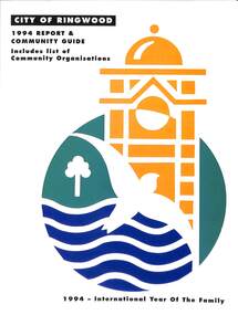 Ringwood and District Historical Society
Book, City of Ringwood, City of Ringwood 1994 Report & Community Guide, 1994
The City of Ringwood and the City of Croydon merged in December 1994 and became the City of Maroondah.Community information book issued by City of Ringwood for 1994 - covering the facilities and activities of the Ringwood Council and other local organisations and associations. Includes Ringwood Public Golf Course discount vouchers and two Ringwood Aquatic Centre bonus entry vouchers.CONTENTS: (page no.) Contents A Message from the Mayor - Cr. Margaret Cheevers 3 Your Council 4 Local State and Federal MPs 5 Council Meetings and Elections 6 History of Ringwood 7 City Manager's Report 8 Organisational structure 9 Human Services 10-19 Environmental Health 20-21 Ringwood Library 22 Parks and Gardens 23 Ringwood's Parks and Reserves 24 Building 25 Engineering Planning Services 26-28 Waste Management 29 Town Planning 30 Traffic and Local Laws 31-33 Roads, Drainage and Major Works 38-39 Halls and Facilities 40-41 Aquatic Centre 42 Convention Centre/Karralika Theatre 43 Golf Course 44 Free Swim & Golf Discount Vouchers 45 Community Organisations 46-64 Finance 65-66 Administration 67 Community Liaison 68 Information Systems 69 Personnel 70-71 Risk Management 71 Rates and Valuations 72 rinx -
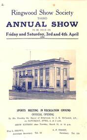 Ringwood and District Historical Society
Booklet, Ringwood Show Society Third Annual Show, 1936
Programme guide for Ringwood's third annual show to be held on Friday and Saturday, 3rd and 4th April, 1936.Includes programme of show events, exhibit categories and judging criteria, sporting actiities, and local advertising. -
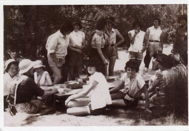 Ringwood and District Historical Society
Photograph, Heathmont Guides - Guide camp -Clifford Park,Wonga Park
Black and white photograph showing guides sitting and standing around low table outdoors."Written on back of photo" Guide camp-Clifford Park,Wonga Park. Heathmont Guides -
 Ringwood and District Historical Society
Photograph, Heathmont Guides at Clifford Park
Black and white photograph showing guides assembled outside"Written on back of photo" Heathmont guides at Clifford Park -
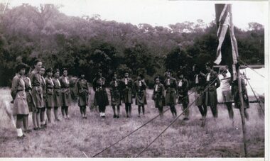
 Ringwood and District Historical Society
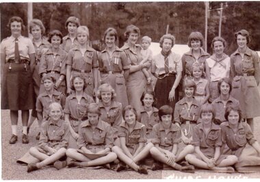
Photograph, Guide House, Yarra Junction- 1962
Photograph showing 1st Heathmont Guides at Guide House, Yarra Junction -1962"Written on back of photo" 1st Heathmont Guides -Guide House, Yarra Junction, 24/01/1962. Back Row: ?, ?, Jill Frame, ?, Kerry Fulton, Hazel Lauder, ?, Lorna Hamer, Avis Frame, Pam Crawford. Middle Row -all unknown. Front Row: ?, ?, ?, ?, Suzanne Cattermole, Marion McRae -
 Ringwood and District Historical Society
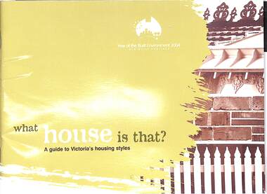
Book, What house is that?, 2007
A guide to Victoria's housing styles and eras (first and second editions)First edition - 2004, The Year of the Built Environment. Foreword by Mary Delahunty, MP, Minister for Planning. Second edition, Foreword by Hon. Justin Madden, MLC, Minister for Planning. -
 Ringwood and District Historical Society
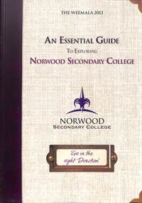
Magazine - Yearbook for Norwood High School/Secondary College, North Ringwood, Victoria, Weemala 2013 An Essential Guide To Exploring Norwood Secondary College
Soft cover school magazinenon-fiction -
 Bendigo Military Museum
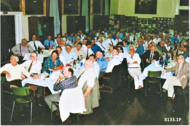
Photograph - BENDIGO RSL ANNUAL DINNERS, C.1998 - 2000
The photos are of one of the last Annual Bendigo RSL Dinners held in the SMI, this is most likely 1998/2000. The Dinners moved to the Bendigo District RSL Sub Branch Inc at Havilah Road about 2001. There are a number of easily identifiable members in the photos. .1) Centre Table, Fred Addlem, Kevin Purdon, Kell Howard, Peter Ball. .2) LH table, Joe Boulton, Ernie Jackman, Jack Fay. Fred Addlem, Refer Cat No 8128P for Committee history, he was also a dedicated Museum guide from 1998 to 2003. Kevin Purdon, has been a Museum Guide since 2009 to current, Appeals for many years and delivery to and pick up from schools. Laurie schilling committee member 1992 to 2000, museum guide from 1998 tp 2015. Kell Howard committee member 1976 to 1981, 1985 to 1990. Peter Ball, refer Cat No 8071.3 Joe Boulton, committee member 1999 to 2000, Appeals Officer with his wife Lyn from 2004 to 2012. Ernie Jackman, committee member 1961 to 1962, 1973, Welfare Sub Committee 15 years, Welfare Officer 1997 to 1978, Appeals Officer 1960 to 1994, organised the distribution of parcels to homes and hospitals at Xmas, made a Life Member 1986. Jack Fay, refer Cat No 8129PTwo Colour photographs re Bendigo RSL Annual Dinners taken from different angles showing 3 lines of tables set up. These photos are one of the last Annual Dinners held in the Soldiers Memorial Institute. The photos show the Museum memorabilia around the walls.brsl, smirsl, annual dinner -
 Warrnambool and District Historical Society Inc.
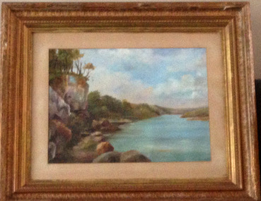
Painting, Hopkins River - Mary Norman - Clifton Banks
Clifton Banks is the name given to a bank on the Hopkins River Estuary, about one kilometre upstream from Proudfoots Boathouse. It is at the foot of the property, Clifton, which dates from 1850s. There are several works of art and photographs of Clifton Banks dating from the late 19th and early 20th centuries. Mary Norman (later known as Mary Norman=Bail) came to Warrnambool in 1901, residing with Canon and Mrs McGeorge. She studied art with Samuel Pearce Fuller and later taught art at Fuller's studio and at a local private school. She produced several seascapes and landscapes while she was in Warrnambool, leaving the town in 1905. She devoted the rest of her life to art as an artist and teacher. In 1922 she married Jess Bail. This art work of Clifton Banks won first prize at the 1902 Annual Ararat Art competitions. It was reported at the time that the work was not a copy but had been drawn from nature. The Warrnambool and District Historical Society has five of Mary Norman-Bail's art work.This is a most significant item as it is one of Mary Norman's art works and she was known in the early 20th century as a competent artist and a member of the Victorian Artists' Society. This art work also has historical significance as one of a number of Clifton Banks representations still surviving. Mary Norman also had an impact on the cultural life of Warrnambool during her short stay in the town. She also returned to teach in the town several times for short periods during the summer vacation times.This is a water colour mounted on art board and with a gilt framed and three outer layers of wooden gilded ornamental frames. The sides of the frames are broken in places and the guided material is somewhat discoloured. There are Les O'Callaghan handwritten notes and some typed material on the back giving information on Mary Norman and the art work. The back is sealed with pasted paper and there are both string and wire attached for hanging the pictureBack of art work: 'Diamond Bros, Photo Enlargers, Importers of Mouldings, Mounting Boards, Albums, Mirrors etc, Picture Framers. Mount Cutters and Plush Workers, Studio - 27 Bridge Road, Melbourne, Factory- 45 and 47 Duke Street, Richmond, Armstrong Street, Ballarat, Pirie Street, Adelaide, Brisbane, & Freemantle W.A.'mary norman, clifton banks, warrnambool -
 Warrnambool and District Historical Society Inc.
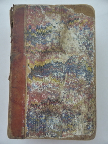
Book, The Child’s Guide to Knowledge, Early 20th century (50th edition)
This book contains information for children on a great variety of topics and is in the form of a catechism with questions and answers. Pearl Davidson would be a member of one of the pioneer Davidson families. The brothers, James, John and William Davidson were early settlers in the Warrnambool district. This book is of antiquarian interest as an early instructional guide for children. It is also of interest because it belonged to a member of the Davidson family, important early settlers in the Warrnambool area. This is a hard cover book of 474 pages. The cover is a mottled brown with gold lettering on the spine. The binding is much worn and partly torn away. The inscription is handwritten in black ink. ‘Pearl Davidson’pearl davidson, the child's guide to knowledge -
 Warrnambool and District Historical Society Inc.
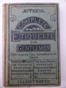
Book, The Complete Etiquette for Gentleman, c.1890
This book has the sub-title: ‘A Complete Guide to the Table, the Toilette and the Ball Room with hints on Courtship, Music and Manners’. It was sold in Warrnambool at the book shop of C. & R. Lavery. They were early Warrnambool settlers and opened their bookselling and newsagent business in 1877. The shop was in the Oddfellows Hall in Koroit Street. This book is of interest as an example of the type of book produced in the late 19th century as an instructional manual for men in the area of manners and etiquette. It is also of interest because it was sold by a local bookstore in Warrnambool. This is a hard cover book of 184 pages. The cover is green with black lines on the cover edges and the titles printed in black lettering. The book has several pages at the front and the back giving information on other books produced by the same publisher (Ward, Lock, Bowden & Co.). These advertisements are accompanied by black and white illustrations. The book has an introduction and 24 sections on etiquette for men for various places and occasions. Each section starts with an ornamental first letter in black and white. The book cover has partly come apart from the pages and the cover is somewhat stained and very faded on the spine. Several of the pages at the back are torn and stained with some of the text missing. There is a label with the sellers’ information pasted on to the back of the front cover. ‘C. & R. Lavery Booksellers Koroit Street Warrnambool’ lavery family, warrnambool, history of warrnambool -
 Warrnambool and District Historical Society Inc.
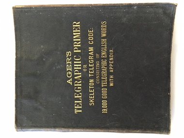
Book, R C Hearson, Telegraph Primer Cramond & Dickson Code book, 1886
This Agers Telegraphic Primer or skeleton telegram guide contains a list of 19000 words which could be used by a business firm to send telegrams overseas in code form. The book once belonged to the Warrnambool firm Cramond and Dickson on the corner of Liebig and Timor Streets which opened a branch of their drapery business in London in 1868. By an agreement with the Reuters Telegram Company in 1899, the code word “sferalcea “ was used for the transmission of telegrams between the two shops. Messages of a general kind were set out at the back of the book: eg: the code word septicity stood for the message, “answer must be here not later than today twelve noon.” The selected words which were used by Cramond and Dickson’s have hand written entries beside the code word. These code books were used to save money and also to improve security.This book has significance on a number of levels. It has local historical significance, is well provenanced. It belonged to one of Warrnambool’s earliest and longest running businesses. The book itself, belonged to the era of early telegraphic communication and as such has wider historical significance.Black soft leather cover with gold lettering, pink inside front and back covers. 312 pages. Up to page 200 the book has words with spaces beside each word to make entries. The back section contains lists of words. Some loose pages and notes contained within the book. Typed page inside front cover from Reuters Telegram Company Limited. Ager’s Telegraphic Primer or skeleton telegram code: consisting of 19000 good telegraphic English words with appendix. Purple stamp inside front cover: Dr Ager 1 Foulden Road Stoke Newingtonwarrnambool, warrnambool history, cramond & dickson, agers telegraphic primer, agers telegraphic primer, reuters telegram company -
 Warrnambool and District Historical Society Inc.
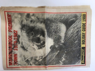
News Sheet, Standard, 1980
... Street (south of Merri St) Warrnambool great-ocean-road ...This Holiday Guide was produced by the Warrnambool Standard with several articles contributed to the supplement by Sally Clark, the Warrnambool Tourist Promotion Officer. Holiday Guides were produced each year to assist and promote tourism in the area. The fact that Warrnambool had won the Premier Town Award for the years 1979-1982 was an added reason for tourists to come to the region and this fact was used as an advertising tool. Warrnambool won the Premier Town Award in 1988 for the third time. This Holiday Guide is of some interest as it shows what was considered the best places for tourists to visit in the Warrnambool region in 1980. The advertisements are also of some value for recording the business life of the city in 1980. This is a 40 page Holiday Guide published by the Warrnambool Standard newspaper in 1980 featuring tourist spots of Warrnambool and district. It includes black and white photographs, maps and advertisements. ‘Warrnambool Premier Town,1979-1982, The Standard, Warrnambool, Holiday Guide 1980’premier town awards, victoria, warrnambool