Showing 55 items
matching road reserve housing
-
 Eltham District Historical Society Inc
Photograph, Pound Bend tunnel, Warrandyte, Warrandyte Mystery Tour, 29 May 1994, 29/05/1994
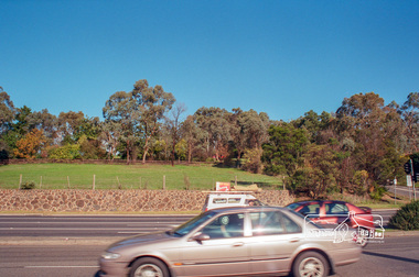
[article by Bettina Woodburn in EDHS Newsletter No. 97, July 1994:] THE WARRANDYTE MYSTERY TOUR MAY 29TH 1994 - Members of the Eltham Historical Society met at the Old Post Office, now converted into the Warrandyte Historical Museum, for a picnic lunch on the sunny back verandah overlooking the shimmering Yarra River. Interesting photographs and artefacts filled various rooms outlining the history of this area, and told tales of Aboriginal and more recent neighbours of the Eltham Shire. The weather was calm, cloudy mostly with only occasional sunny patches, but it wasn't cold, although the autumnal leaf colours had changed to wintry brown. "All Aboard" and we set off in the Warrandyte Community Bus (with the School Bus sign displayed at the rear) to learn about local places of "Pride and Joy” from Bruce our guide and Tom the driver. Almost directly opposite we entered Whipstick Gully to explore the first of the district's hidden treasures - the Victory, one of the largest of the six or so major mines, past the old quarry now used for abseiling practice. By torchlight we entered the rocky hillside and saw the seams of quartz the miners had followed in their search for gold. Stamping batteries, and there was one in this gully, converted discarded rock into 'road metal'. Warrandyte is proud to be the first declared Goldfield in 1851, and one of the longest surviving, into the 1920s. A pleasant drive across the Bridge and along Bradley's Lane to Norman's Reserve brought us to see another Tunnel at Pound Bend through which the Yarra was diverted to allow about three miles of river-bed to be used for prospecting for alluvial gold. Still on this side of the river we visited the Old Slab Hut in Castles Road. This remnant of miners' housing is preserved because it had been incorporated into a weatherboard house, and saved from the bulldozers - a last minute reprieve, for preservation, by the National Trust. Devastating bush fires have destroyed other old cottages built of wattle and daub, with bark roofs and stone fire-places. The Cairn commemorating the disclosure of Gold Discovery at Warrandyte on June 30th 1851 beside Anderson's Creek Road was our next point of historical interest. We drove on to South Warrandyte and circled back to above the ford on Anderson's Creek to the entrance of the 4th Hill Mine. Again we crept along with our torches, careful of the low roof-rock, and side shafts. At a junction in a large cavity we were able to stand, look up a long air-vent which some 'cavers' climb down, and marvel at, and experience an aspect of a miner's life. Outside we heard the same bird songs, the trills and bell-pealing, saw the same straggly eucalypts, and a silver leafed wattle in flower, native grasses and ferns, and the neat present day houses, often of Warrandyte stone, perhaps veneered only. The day ended pleasantly, seeing more of the Yarra from Everard Drive, and the water rushing out of the Tunnel at Pound Bend, before returning to afternoon tea or coffee at the Museum. A great day for all concerned - many thanks to the Organisers.Two colour photographswarrandyte, activities, pound bend -
 Eltham District Historical Society Inc
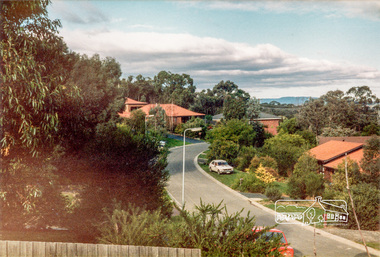
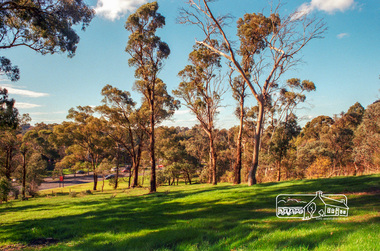
Photograph, Fitzsimons Lane Reserve bounded by Main Road, Bolton Street and Fitzsimons Lane, Eltham, c.May 2001
Viewed from Main Road just east of Bolton Street, approaching Fitzsimons Lane roundabout. Now partially developed as the Monarch Ridge housing estateRoll of 35mm colour negative film, 7 stripsAgfa HDC 200 plus-2eltham, streets, main road, fitzsimons lane reserve, houses, monarch ridge estate -
 Eltham District Historical Society Inc
Photograph, Stokes Place, Eltham, June1986; looking southeast from linear park reserve near no. 10, 1980
14 Stokes Place was the home of Peter and Carla Vermey who had migrated to Australia from Holland. The land was purchased in May 1979 and the home built by Peter and Carla Vermey after the developer, Macquarie Builders went bankrupt. Sold October 2017 by Morrison and Kleeman Real Estate. Stokes Place was part of the Stokes Orchard Estate which was developed from the break-up of the the orchard owned by Frank Stokes who lived on the northeast corner of Nyora Road and Eucalyptus Road. His daughter Beryl advised that the Shire had levied a rate assessment on individual parcels of land within the orchard which became unaffordable resulting in its sub-division and sell off. The Stokes Orchard Estate was developed by Macquarie Builders in two stages starting with stage 1 in 1976. Stokes Place was part of Stage 2 in 1979. The Estate was bounded between Nyora Road, Eucalyptus Road, Diosma Road and Stokes Place. The original orchard only just reached the left most portions of Stokes Place and did not go fully up to Diosma, rather to just beyond the extant of Stokes Place. Stokes Place was known within the family as "The Oats" as that is where they grew oats. Frank Stokes moved to Eltham c.1945 after visiting Harold Bird to view his orchard, located diagonally opposite Stokes Orchard from the intersection of Eucalyptus Road, Pitt Street and Nyora Road. It was on Harold Bird's recommendation that Frank purchased the land.The Stokes Orchard Estate collection is typical of housing developments of the late 1970s and 1980s. It was one of the earliest estates in Eltham following the nearby Woodridge Estate development.Digital fileScanned from a print contained in owner's photo album (81 prints in total digitised)stokes place, eltham, stokes orchard, stokes orchard estate, streets, houses, peter and carla vermey -
 Eltham District Historical Society Inc
Photograph, Fitzsimons Lane Reserve bounded by Main Road, Bolton Street and Fitzsimons Lane, Eltham, c.May 2001
Now partially developed as the Monarch Ridge housing estateRoll of 35mm colour negative film, 7 stripsAgfa HDC 200 plus-2eltham, streets, main road, fitzsimons lane reserve, houses, monarch ridge estate -
 Eltham District Historical Society Inc
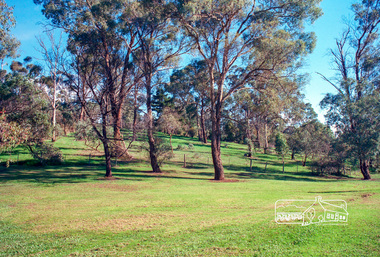
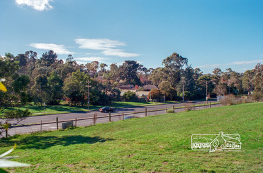
Photograph, Reserve bounded by Main Road, Bolton Street and Fitzsimons Lane, Eltham, c.May 2001
Now developed as the Monarch Ridge housing estateRoll of 35mm colour negative film, 7 stripsAgfa HDC 200 plus-2eltham, streets, main road, fitzsimons lane reserve, monarch ridge estate -
 Eltham District Historical Society Inc
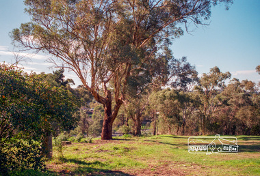
Photograph, Fitzsimons Lane Reserve bounded by Main Road, Bolton Street and Fitzsimons Lane, Eltham, c.May 2001
Now partially developed as the Monarch Ridge housing estateRoll of 35mm colour negative film, 7 stripsAgfa HDC 200 plus-2eltham, streets, main road, fitzsimons lane reserve, monarch ridge estate -
 Eltham District Historical Society Inc
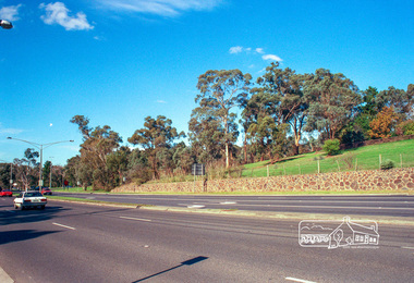
Photograph, Fitzsimons Lane Reserve bounded by Main Road, Bolton Street and Fitzsimons Lane, Eltham, c.May 2001
Viewed from Main Road just east of Bolton Street, approaching Fitzsimons Lane roundabout. Now partially developed as the Monarch Ridge housing estateRoll of 35mm colour negative film, 7 stripsAgfa HDC 200 plus-2eltham, streets, main road, fitzsimons lane reserve, houses, monarch ridge estate -
 Eltham District Historical Society Inc
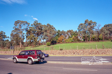
Photograph, Fitzsimons Lane Reserve bounded by Main Road, Bolton Street and Fitzsimons Lane, Eltham, c.May 2001
Viewed from Main Road just east of Bolton Street, approaching Fitzsimons Lane roundabout. Now partially developed as the Monarch Ridge housing estateRoll of 35mm colour negative film, 7 stripsAgfa HDC 200 plus-2eltham, streets, main road, fitzsimons lane reserve, houses, monarch ridge estate -
 Glen Eira Historical Society
Photograph, Dalny Road, 5-17 Rear, Murrumbeena, 2001
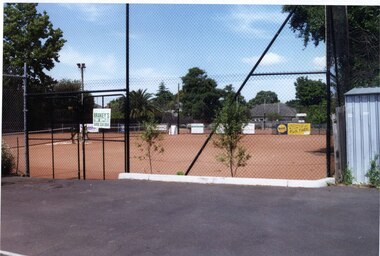
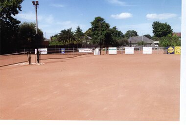
Originally labelled "Beauville Estate, Established 1936, Still Thriving 65 years on, 10th March 2001", the Beauville Estate Album contains colour photographs of houses in the Estate. They were taken around the time of the Beauville Estate’s 65th Heritage Celebration held on 10/03/2001 and donated to the Caulfield Historical Society shortly afterwards. Photographer unknown. From Glen Eira’s Heritage Management Plan by Andrew Ward (1996) Vol 2 p78: "Beauville Avenue is unusual in that it is terminated in a cul-de-sac (see Section 3.9.2) whilst the design of the estate may well be unique for its time in that the houses back onto 6 tennis courts for public use. St. Patrick's Church, which adjoins the estate is a comparatively recent structure whilst the school has one building erected in 1930 and prior to the release of the Beauville lots." It also notes that St.Patrick's Church and School now run the tennis courts.City of Glen Eira’s Heritage Management Plan Vol 2 p79 (this is p84 of the pdf version) – HO12 Beauville Estate and environs, Murrumbeena: The Beauville Historic Area is important at the State level as the first large housing estate undertaken by the AV Jennings Construction Co, later Jennings Group Limited, Victoria’s largest home builder. It is important also as a very early estate development incorporating a range of features other than houses and including made roads, shops and recreation facilities. In this respect it was the forerunner of the comprehensively planned housing estate of the post war era. The estate is distinguished by its aesthetic values, as is the earlier and comparable Hillcrest Estate, which are formed by a combination of restrained diversity in house styles, with the exception of no. 30 in the emerging International style, and by a landscaped garden environment. Colour photograph of a tennis club house and a park on the Beauville Estate. murrumbeena, houses, 1930's, a.v. jennings, av jennings, jennings, beauville estate, jennings albert victor, parks and reserves, sports and recreations establishments, clubhouses, tennis clubs, beauville tennis courts, st patrick's tennis club, sir albert victor jennings, a v jennings construction co, beauville estate heritage area, glen eira city council, architectural features, jennings group limited, land subdivision, gardens, beauville historic area, dalny road -
 Glen Eira Historical Society
Photograph, Dalny Road, 5-17 Rear, Murrumbeena, 2001
Originally labelled "Beauville Estate, Established 1936, Still Thriving 65 years on, 10th March 2001", the Beauville Estate Album contains colour photographs of houses in the Estate. They were taken around the time of the Beauville Estate’s 65th Heritage Celebration held on 10/03/2001 and donated to the Caulfield Historical Society shortly afterwards. Photographer unknown. From Glen Eira’s Heritage Management Plan by Andrew Ward (1996) Vol 2 p78: "Beauville Avenue is unusual in that it is terminated in a cul-de-sac (see Section 3.9.2) whilst the design of the estate may well be unique for its time in that the houses back onto 6 tennis courts for public use. St. Patrick's Church, which adjoins the estate is a comparatively recent structure whilst the school has one building erected in 1930 and prior to the release of the Beauville lots." It also notes that St.Patrick's Church and School now run the tennis courts.City of Glen Eira’s Heritage Management Plan Vol 2 p79 (this is p84 of the pdf version) – HO12 Beauville Estate and environs, Murrumbeena: The Beauville Historic Area is important at the State level as the first large housing estate undertaken by the AV Jennings Construction Co, later Jennings Group Limited, Victoria’s largest home builder. It is important also as a very early estate development incorporating a range of features other than houses and including made roads, shops and recreation facilities. In this respect it was the forerunner of the comprehensively planned housing estate of the post war era. The estate is distinguished by its aesthetic values, as is the earlier and comparable Hillcrest Estate, which are formed by a combination of restrained diversity in house styles, with the exception of no. 30 in the emerging International style, and by a landscaped garden environment. Colour photograph of tennis courts and surrounding mesh fencing on the Beauville Estate. murrumbeena, houses, 1930's, a.v. jennings, av jennings, jennings, beauville estate, parks and reserves, sports and recreations establishments, tennis courts, sportsgrounds, sir albert victor jennings, a v jennings construction co, beauville estate heritage area, glen eira city council, architectural features, jennings group limited, land subdivision, gardens, beauville historic area, tennis clubs, beauville tennis courts, st patrick's tennis club, dalny road -
 Glen Eira Historical Society
Photograph, Dalny Road, 5-17 Rear, Murrumbeena, 2001
Originally labelled "Beauville Estate, Established 1936, Still Thriving 65 years on, 10th March 2001", the Beauville Estate Album contains colour photographs of houses in the Estate. They were taken around the time of the Beauville Estate’s 65th Heritage Celebration held on 10/03/2001 and donated to the Caulfield Historical Society shortly afterwards. Photographer unknown. From Glen Eira’s Heritage Management Plan by Andrew Ward (1996) Vol 2 p78: "Beauville Avenue is unusual in that it is terminated in a cul-de-sac (see Section 3.9.2) whilst the design of the estate may well be unique for its time in that the houses back onto 6 tennis courts for public use. St. Patrick's Church, which adjoins the estate is a comparatively recent structure whilst the school has one building erected in 1930 and prior to the release of the Beauville lots." It also notes that St.Patrick's Church and School now run the tennis courts. City of Glen Eira’s Heritage Management Plan Vol 2 p79 (this is p84 of the pdf version) – HO12 Beauville Estate and environs, Murrumbeena: The Beauville Historic Area is important at the State level as the first large housing estate undertaken by the AV Jennings Construction Co, later Jennings Group Limited, Victoria’s largest home builder. It is important also as a very early estate development incorporating a range of features other than houses and including made roads, shops and recreation facilities. In this respect it was the forerunner of the comprehensively planned housing estate of the post war era. The estate is distinguished by its aesthetic values, as is the earlier and comparable Hillcrest Estate, which are formed by a combination of restrained diversity in house styles, with the exception of no. 30 in the emerging International style, and by a landscaped garden environment. Colour photograph of tennis courts with lights on the Beauville Estate. murrumbeena, houses, 1930's, a.v. jennings, av jennings, jennings, beauville estate, parks and reserves, sports and recreations establishments, tennis courts, sportsgrounds, sir albert victor jennings, a v jennings construction co, beauville estate heritage area, glen eira city council, architectural features, jennings group limited, land subdivision, gardens, beauville historic area, tennis clubs, beauville tennis courts, st patrick's tennis club, dalny road -
 City of Moorabbin Historical Society (Operating the Box Cottage Museum)
Flyer - Smith's Estate, Highett
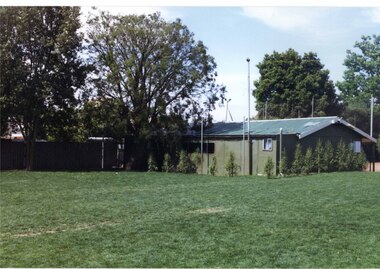
The train line from the city to Mordialloc was built which opened up the land for housing development. The section bounded by Peterson Street Telford Street and Highett Road is now Peterson Street Reserve.Example of the progress of the Municipality of MoorabbinAdvertising flyer for auction of real estate sales - plan of building blocks for saleSmith's Estate, Highett - J. F. Bradyhighett, real estate, highett road, hillside street (no longer exists), peterson st, frederico st, tolhurst st (no longer exists), wickham road, danson street, peterson street reserve -
 Whitehorse Historical Society Inc.
Article, Farm digs in against closure, 2013
Land reserved for Healesville Freeway is at risk of being broken up for housing.Land reserved for Healesville Freeway is at risk of being broken up for housing. Some of the area is used at present for a farm run by NADRASCA, and other land is the nature reserve, Bellbird Dell. More than 1500 protested against the closure to local MP Shaun Leane.Land reserved for Healesville Freeway is at risk of being broken up for housing. healesville freeway reservation, bellbird dell, nadrasca, leane, shaun, vermont, koedyk, gus, turner, raeoni, kayne, rodney, basic, peter, vicroads -
Whitehorse Historical Society Inc.
Article, Housing plan for reserve, 2012
VicRoads has earmarked large parts of the Healesville Freeway Reservation for housing under concept plans for the land's future.VicRoads has earmarked large parts of the Healesville Freeway Reservation for housing under concept plans for the land's future. Some community groups and Whitehorse Council are calling for the entirety of the reserve to be preserved as open space.VicRoads has earmarked large parts of the Healesville Freeway Reservation for housing under concept plans for the land's future. healesville freeway reservation, whitehorse -
Whitehorse Historical Society Inc.
Article, Housing plan for reserve, 2014
Housing on the Healesville Freeway Reserve .Housing on the Healesville Freeway Reserve could help meet increasing demand for properties according to Noel Jones Real Estate.Housing on the Healesville Freeway Reserve .healesville freeway reserve, noel jones -
Whitehorse Historical Society Inc.
Article, Reserve balance is right: residents, 2014
Open space and housing balance proposed by the Whitehorse Council.Open space and housing balance proposed by the Whitehorse Council has been approved by many residents and Friends of Healesville Freeway Reserve. The Nunawading Community Gardens will be retained.Open space and housing balance proposed by the Whitehorse Council. nunawading community gardens, friends of healesville freeway reserve, makhijani, anne, healesville freeway reserve, vicroads, city of whitehorse -
Kew Historical Society Inc
Journal, Kewriosity : November 1985
Our window [Alan Sumner, The Four Seasons] / p1. Linear Park will not affect E6 [Outer Circle railway reserve] / p1&5. Dates for November / p2&8. [Community] Notices / p2. Update: Notes from Council - [Council] Budget Go-ahead / Cr Phyllis Hore [Mayor of Kew] / p3. Traffic management / p3. In Brief [Recycling transfer; Walmer Street Appeal quashed; Deregulation of shared housing; Review sought on full day care decision; Whither Willsmere?; Cable tram centenary exhibition; Election possible; Community Assistance Grants] / p4. Death of Councillor Murray Wood / p4. 40 years of home-help in Kew / p5. Three year old Kinder [Argyle Road; Davis Street] / p5. Youth Page - New publications for youth [Streetwise comics; Making unemployment work] / p6. How we passed our time - 2 [social history] / Bill Stent p7. A Group Apprenticeship Scheme for Eastern Suburbs / p7. Kew Community House / p8. Room for one more [student hosting] / p8. North Kew Tennis Club / p8. Kew Young Liberals / p8. Kew Band in concert / p8.Kewriosity was a local newsletter combining Kew Council and community news. It was published between November 1983 and June 1994, replacing an earlier Kewriosity [broad] Sheet (1979-84). In producing Kewriosity, Council aimed to provide a range of interesting and informative articles covering its deliberations and decision making, together with items of general interest and importance to the Kew community and information not generally available through daily media outlets.non-fictionOur window [Alan Sumner, The Four Seasons] / p1. Linear Park will not affect E6 [Outer Circle railway reserve] / p1&5. Dates for November / p2&8. [Community] Notices / p2. Update: Notes from Council - [Council] Budget Go-ahead / Cr Phyllis Hore [Mayor of Kew] / p3. Traffic management / p3. In Brief [Recycling transfer; Walmer Street Appeal quashed; Deregulation of shared housing; Review sought on full day care decision; Whither Willsmere?; Cable tram centenary exhibition; Election possible; Community Assistance Grants] / p4. Death of Councillor Murray Wood / p4. 40 years of home-help in Kew / p5. Three year old Kinder [Argyle Road; Davis Street] / p5. Youth Page - New publications for youth [Streetwise comics; Making unemployment work] / p6. How we passed our time - 2 [social history] / Bill Stent p7. A Group Apprenticeship Scheme for Eastern Suburbs / p7. Kew Community House / p8. Room for one more [student hosting] / p8. North Kew Tennis Club / p8. Kew Young Liberals / p8. Kew Band in concert / p8. publications -- city of kew (vic.), kewriosity, council newsletters, community newsletters -
 Kew Historical Society Inc
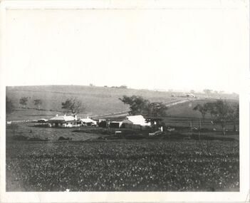
Photograph, Kilby Farm, Kew East, Before 1920
Kilby Lodge (c.1845-c.1922). William Oswin purchased Crown Land Lots 52 & 53 in 1845. These lots ran north from an old bullock track [later Kilby Road] to the Yarra, and east to Burke Road. Oswin purchased a neighbouring Lot in 1851, separated by the bullock track from the rest of the farm. Oswin built ‘Kilby Lodge’ and, with his brother, farmed dairy cattle on the site. Oswin’s descendants owned the farm into the 1890s. New subdivisions of Kilby and neighbouring farms in the 1920s changed the rural nature of north Kew. Housing and large recreation reserves replaced dairy farms and market gardens. This work forms part of the collection assembled by the historian Dorothy Rogers, that was donated to the Kew Historical Society by her son John Rogers in 2015. The manuscripts, photographs, maps, and documents were sourced by her from both family and local collections or produced as references for her print publications. Many were directly used by Rogers in writing ‘Lovely Old Homes of Kew’ (1961) and 'A History of Kew' (1973), or the numerous articles on local history that she produced for suburban newspapers. Most of the photographs in the collection include detailed annotations in her hand. The Rogers Collection provides a comprehensive insight into the working habits of a historian in the 1960s and 1970s. Together it forms the largest privately-donated collection within the archives of the Kew Historical Society.A panoramic photograph of Kilby (or Oswin's) Farm in East Kew."Kilby Farm when Oswins owned it. Commenced 1845."kilby farm, kilby lodge, william oswin, dorothy rogers, kew east -
 Melton City Libraries
Photograph, Western Highway, 1983
Construction of service road in front of the former Ann Dowling (Miers) 1866 Crown Grant, Title dated October 1870. She married Henri Miers in 1867.Their house was located on the site near the Myers Gully part of Ryans Creek. Built in 1867 and later named “Burnbank” by Martha Myers after the Street in Ballarat were she lived before arriving in Melton in 1907. She married Frederick Myers in 1908. He died in 1963, and Martha moved to a new home at 5 McKenzie Street Melton in 1968. Attempts made by the family to retain the historic cottage were unsuccessful. A demolition order imposed by the Housing Commission and it was pulled down by the family. It was the home of the family and stood for over 100 years.East of Reserve Road towards Ferris Roadlandscapes of significance, misc. -
 Harcourt Valley Heritage & Tourist Centre
concrete blocks, 1914
Charles Seelenmeyer conducted Concrete Utilities Limited (Harcourt Cement Pipe Factory). Operated in Harcourt circa 1914 to 1930 in premises situated opposite the ANA Hall on what is now the road reserve. Principal raw material was sand from the adjacent waterway ( Barkers Creek.) Principal output was concrete drainage tiles for use in district orchards but concrete blocks were also produced for construction of homes and commercial buildings. At a time of rapid expansion of the orchards this industry provided a vital piece of orchard infrastructure, mostly buried and not now visible but nevertheless a very important feature of the valley’s horticultural industry.. Homes built with these concrete blocks are a distinct part of Harcourt’s housing stock. Harcourt Cement Pipe Co was an example of local initiative to solve a local problem using local materials. A collection of 4 concrete building blocks -
City of Kingston
Photograph - Colour, c. 1993
Patterson Lakes is a suburb in the City of Kingston that is built one kilometre upstream of the mouth of the Patterson River. The area is bordered by the Patterson River and Eel Race Drain which enters the Kananook Creek. The suburb consists predominantly of newer housing developments and the tidal canal system of the development joins Port Phillip Bay.Patterson Lakes and the Kananook Creek were previously part of the extensive Carrum Carrum Swamp. The area was once a source of fish and eels for the Mayone-Bulluk clan of the Bunurong people. Over time the area was drained and in 1973 investigations commenced into the development of a unique residential area that would be built adjacent to canals and waterways. It was originally proposed to be known as "Gladesville". The development would give the suburb's homeowners access to Port Phillip Bay "from their back door". Circa 1974, the area was rezoned from rural to residential and named Patterson Lakes. Development has been continuous since the 1970s with construction of residential housing, schools, shopping centres, marinas, a hotel and library.Laminated colour aerial photograph of the Carrum and Patterson Lakes region within City of Kingston. This 1993 image includes Patterson River Secondary College, Roy Dore Reserve, Kananook Creek and Nepean Highway. The railway line can be seen as it veers inland from Eel Race Road, Seaford. The section of Palm Beach Drive, Curlew Point Drive, Snapper Point Drive, Clipper Island and Myola Street in Patterson Lakes appears to be a recent development with many spare blocks and new houses under construction.patterson lakes, seaford, kananook creek, carrum carrum swamp, canals and waterways -
 City of Kingston
Photograph - Black and white, 20 December 1945
This aerial photograph depicts the changing landscape of Cheltenham and Highett since WWII. Photographed in 1945, there is a mix of urban dwellings and industrial development and precedes the major transformation of Cheltenham with the development of the Southland shopping centre in the 1960s and expansion in the 1990s.A large part of Cheltenham was originally established as a rural market gardening community. The railway line and station brought urban development to the area and in the north, the Highett area was dominated by the Highett Gas Works. Cheltenham became a major destination for shopping in the 1960s with the opening of Southland.Aerial photograph taken in 1945 of Cheltenham and Highett within the City of Kingston. The image includes the Highett Reserve, (top right), the Methodist Children Homes (now Southland), Nepean Highway and Jamieson Street. Highett Gas Works is visible in the top left and the land now named William Fry Reserve at the intersection of Bay Road and Nepean Highway. A visible large parcel of land on the corner of Bay Road and Nepean Highway was developed in the 1990s as the west side addition to Southland. The densely vegetated area in the upper right sector of the image is now dense with housing. Tulip Grove, Heather Grove and Gilford Street are visible bottom left. This image is possibly from the collection of aerial photographs commissioned by the Department of Crown Lands and Survey and taken by Adastra Airways.Black ink: 57252 White lettering: VIC-10 57252 20.12.45 [lens information indecipherable] PROJ. No.5 MELB. METROP AREA Black pencil: 80highett, cheltenham, highett gas works, urbanisation -
 City of Kingston
Photograph - Black and white, 20 December 1945
This aerial photograph depicts the changing landscape of Cheltenham and Highett since WWII. Photographed in 1945, there is a mix of urban dwellings and industrial development and precedes the major transformation of Cheltenham with the development of the Southland shopping centre in the 1960s and expansion in the 1990s.A large part of Cheltenham was originally established as a rural market gardening community. The railway line and station brought urban development to the area and in the north, the Highett area was dominated by the Highett Gas Works. Cheltenham became a major destination for shopping in the 1960s with the opening of Southland.Aerial photograph taken in 1945 of Cheltenham and Highett within the City of Kingston. The image includes the Highett Reserve, (top right), the Methodist Children Homes (now Southland), Nepean Highway and Jamieson Street. Highett Gas Works is visible in the top left and the land now named William Fry Reserve at the intersection of Bay Road and Nepean Highway. A visible large parcel of land on the corner of Bay Road and Nepean Highway was developed in the 1990s as the west side addition to Southland. The densely vegetated area in the upper right sector of the image is now dense with housing. Tulip Grove, Heather Grove and Gilford Street are visible bottom left. This image is possibly from the collection of aerial photographs commissioned by the Department of Crown Lands and Survey and taken by Adastra Airways.Black type: Reverse lettering VIC-10 57252 20.12.45 [lens information indecipherable] PROJ. No.5 MELB. METROP AREA White lettering: Reverse writing 57252cheltenham, highett, highett gas works, urbanisation -
City of Kingston
Photograph - Black and white, 5 January 1984
Moorabbin, Cheltenham and Highett are suburbs in the City of Kingston with a diverse mix of development and zoning. The market gardens, farms and paddocks have gradually been sub-divided into housing and industrial estates and associated infrastructure such as schools and shopping facilities. The area includes many parks, reserves and golf courses.This aerial image covers a diverse section of the City of Kingston, taking in the suburbs of Cheltenham, Moorabbin, Beaumaris and Highett. By 1984, the market gardens of the district have been replaced by housing and factories. The Gas and Fuel state-of-the-art Scientific Services Department is visible on Nepean Highway Highett. The CSIRO Highett site can also be seen. Both sites have now been demolished and have undergone remediation. The Southland site is visible and yet to be redeveloped by Westfield. This image portrays the diversity of development in the City of Kingston with a mixture of green spaces, housing and commercial and industrial features.Aerial photograph of Cheltenham, Beaumaris, Moorabbin and Highett within the City of Kingston. The area depicted in the 1984 aerial view includes Eden Street and Edward Street, Cheltenham (top left), Weatherall Road and Reserve Road, Cheltenham/Beaumaris (top right), Turner Road and Chesterville Road, Moorabbin (bottom left), Nepean Highway (left section), Graham Road and Middleton Street, Highett (bottom right). A large section of this image includes Cheltenham Park and Victoria Golf Club.White text: 3831-219 Lens information [indecipherable] RINGWOOD M/S 7922-3 RUN 15 Clockface image 5,300' ASL VIC DLS© 5-1-84cheltenham, highett, industrialisation, urbanisation, moorabbin, beaumaris