Showing 288 items
matching settlement house
-
 Phillip Island and District Historical Society Inc.
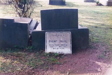
Photograph Album, Kodak, Phillip Island Cemetery, c 1990
The Album was compiled by Nancy McHaffie late 1990's, with the assistance of Edith Jeffery's, with her book "Garden of Memories" and extensive knowledge of Phillip Island. The Cemetery lies back from the road and is surrounded by Manna Gums, rare Peppermint Gums, Blackwoods and other native trees. In all 25 acres of land were set aside as Crown Land in the land settlement of 1868. There are 6.2 acres of wetlands near the cemetery entrance.FANNY LAGAL (nee THOMPSON): Fanny arrived in Australia in the early 1920s. After her husband died she arrived on Phillip Island. She worked at "Summerland House" and later at the "Isle of Wight Hotel". She took great pride in keeping the altar linen and generally looking after the Anglican Church. Those who knew her said she was a gracious lady with a great sense of humour. Fanny went to a nursing home at Frankston where she resided until she died in February 1980, aged 90. Friends arranged for her to be buried at the Cemetery.phillip island cemetery, fanny lagal nee thompson, nancy mchaffie, edith jeffery -
 Phillip Island and District Historical Society Inc.
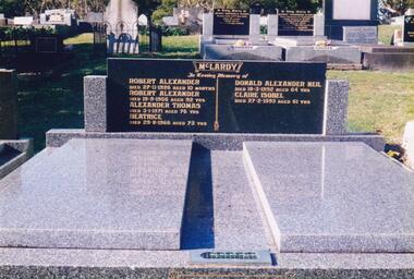
Photograph Album, Kodak, Phillip Island Cemetery, c 1990
The Album was compiled by Nancy McHaffie late 1990's, with the assistance of Edith Jeffery's, with her book "Garden of Memories" and extensive knowledge of Phillip Island. The Cemetery lies back from the road and is surrounded by Manna Gums, rare Peppermint Gums, Blackwoods and other native trees. In all 25 acres of land were set aside as Crown Land in the land settlement of 1868. There are 6.2 acres of wetlands near the cemetery entrance.466-56: Alexander McLardy Sr. The descendants of Alex McLardy came to Phillip Island in the year 1886. A builder by trade, he built a great number of houses and buildings on the Island. He was also the founder of the Guesthouse "Glencoe". At 90 years of age he could still read well without the aid of glasses. He died in 1956 aged 95. Others buried in the double graves are: Robert Alexander died 1926 aged 10 months, Alexander Thomas died 1971 aged 76, Beatrice died 1966 aged 73, Donald Alexander died 1992 aged 64 and Claire Isobel died 1993 aged 61. 466-57: Walter Findlay. Walter's parents George and Mary, came to Australia in 1852. Walter was born in Sale circa 1883. He married Henrieta Kennon and they lived and farmed in Settlement Road, Cowes prior to their shop and residence being built in Warley Avenue, Cowes. The shop carried general merchandise and confectionery. The property was absorbed by Bass Coast Family Medicine on the west side of Warley Avenue. Henrieta died September 1965 aged 84. Walter died July 1965 aged 82.phillip island cemetery, alexander mclardy, walter findlay, nancy mchaffie, edith jeffery -
 Phillip Island and District Historical Society Inc.
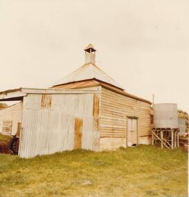
Photograph, 1978/79
Chicory Kiln alongside the house of Mr T Woods in Settlement Road, East Cowes, was built in approx. 1870. It had 18" thick mud brick walls at the core.Photograph of Chicory Kiln on Settlement Road, East Cowes, on land owned by Mr. T. Woods.local history, photographs, buildings - historical, housing, rural industry, coloured photograph, john cook, phillip island, t woods -
 Phillip Island and District Historical Society Inc.
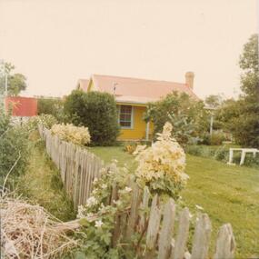
Photograph, 1978/79
House built by Henry Jenner, Senior - about 1870 for Mr T Woods. Possibly originally built of mud and sticks.Photograph of the home of Mr T Woods which was in Settlement Road, East Cowes. Taken looking towards the back of the house with garden in foreground. Note twin roof line. Water tank on left of picture.local history, photographs, buildings - historical, coloured photograph, john cook, phillip island, t woods home -
 Glenelg Shire Council Cultural Collection
Book, People of the Lake - the story of Lake Condah Mission, n.d
27,000 years ago molten lava pouring from the eruption of Budjbim (Mt. Eccles) formed Lake Condah and the unique landscape that surrounds it. Over time this area known as "The Stony Rises" or "The Stones" became an important geological area for Koories and, later, Europeans.12 page A4 size booklet, cream with brown print.27,000 years ago molten lava pouring from the eruption of Budjbim (Mt. Eccles) formed Lake Condah and the unique landscape that surrounds it. Over time this area known as "The Stony Rises" or "The Stones" became an important geological area for Koories and, later, Europeans.aboriginal history, gunditjmara, lake condah, mission history, budj bim -
Glenelg Shire Council Cultural Collection
Newspaper - Newspaper - Portland Observer 150th Celebration Supplement, n.d
Printed supplement promoting events of Portland's 150th Celebrations, November 17 - Dececember 1, 1984, also lists history of Portland settlement and other facts. -
Glenelg Shire Council Cultural Collection
Book - Book Publication - 1984 150th Anniversary of Portland, 1984
A4 size publication 'Portland', made for 1984 150th Anniversary of Portland as Victoria's first permanent settlement. Covers cardboard, content, coloured photographs with black text. Front cover has photographs with black text. Front cover has photographs of Kingsley, historic painting, harbour at sunset, lifesavers, oil rig and yachts Henty Beach; with red border. Back Cover: Glenelg river -
Glenelg Shire Council Cultural Collection
Booklet, A Homely Chat About Dairying, 09/1888
A booklet, containing a lecture on model dairies, 'A Homely Chat About Dairying'; delivered by Mr. D. Wilson, at the Centennial International Exhibition, 8th September 1888.centennial exhibition, melbourne exhibition building, 1888, dairy, rural industry -
Glenelg Shire Council Cultural Collection
Medal, Centenary of Melbourne 1835 Commemorative Medallion, 1834
White metal medal issued to commemorate Melbourne's centenary 1934-35. This medal was given out to Victorian school children; 325,600 white metal medals were struck. There were also a few VIP pieces in other metals, including two in gold. The medal references Portland, the location of Victoria's first settlement. The Henty brothers, entrepreneur farmers and whalers, established the state's first permanent European settlement in Portland in 1834. Melbourne was established the following year by a party of settlers led by John Batman.White metal medal. Medal, silver. with hole and ring at the top. Obverse: Sailing Ship, Coast, Boat on shore, 3 men. Reverse Colonial man on grass, river, city buildings on other river bank Medal commemorates the centenary of Victoria and Portland 1834 and Melbourne 1835. Obverse:Scene of landing at Portland Bay; in ground below, PORTLAND / 1834; above, centenary of victoria / 1934 Reverse: Pioneer on south bank of Yarra looking across to Melbourne, below 1835 above, CENTENARY / OF / MELBOURNE / 1935Front: Inverse: Centenary of Melbourne 1835 (Top) 1835 (Bottom) Back: Obverse: Centenary of Victoria 1934 (Round Top) Portland 1834 (Bottom)medal, numismatics, celebration, 1834, 1934, 1935, melbourne, portland -
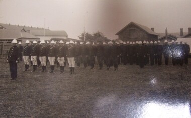 Glenelg Shire Council Cultural Collection
Postcard - Postcard - Police escort for Duke of Gloucester, Portland, 1934, 1934
HRH Prince Henry Duke of Gloucester came to Australia in late 1934, and to Victoria in time for the Centenary Celebrations (of pastoral settlement of the Port Phillip District, beginning with the Hentys settlement at Portland Bay on 19 November 1834). From Trove - 20 November 1934 Historic Portland was the scene yesterday of unprecedented celebrations when the Duke of Gloucester arrived from Tasmania to join in festivities marking the beginning of Victoria's second century. A great crowd estimated at more than 60,000 people watched the re-enactment of the landing of Edward Henty, Victoria's first permanent settler, on November 19, 1834.Black and white photograph rows of men in formal dress with white jodhpurs, dark coats and white hats. Five rows in all, with one man at the front. Buildings in the background. Police escort for Duke of Gloucester, Portland, 1934Front: (no inscriptions) Back: Police escort for Duke of Gloucester Portland 1934royal visit, 1934, duke of gloucester -
Glenelg Shire Council Cultural Collection
Certificate - Certificate - Historic Buildings, Portland Town Hall, 1974
From the Victorian Heritage Register: The foundation stone of the original Portland Town Hall was laid by William Learmonth on 21st September, 1863 following a competition and subsequent public controversy over the permitted entry of architect John Barrow. The conservative classical design of municipal surveyor Alexander Ross was preferred and this axially planned design with central council chamber and side offices fronted by a fine axed pedimented gable entablature of basalt and Tuscan Doric pilasters was completed by 24th may 1864. The old Town Hall is one of a distinguished group of public buildings in Portland and an interesting example of conservative classical architecture of the first years of settlement in western Victoria. The basalt structure was partially erected of stone from the Portland stockade and has significant historical associations with local Government administration in the district. The Town Hall is the most impressive work of Alexander Ross, a surveyor architect whose career remains largely undocumented. The old Town Hall at Portland has been discreetly extended at the rear to provide additional meeting room accommodation. The premises are no longer used for local government administration.A4 sized certificate demonstrating Portland Town Hall's special significance to the state of Victoria & inclusion on the Historic Building Register. Singed by Robert Maclellan, Minister for planning & Historic Buildings Council Chairperson. Red seal attached, bottom right.portland town hall, history house, heritage register, historic buildings, certificate -
Glenelg Shire Council Cultural Collection
Functional object - Sticker, PORTLAND 150th, n.d
Portland celebrated the 150th anniversary of its formation as a town in 1984. A number of commemorative items were produced.Oblong-shaped promotional sticker, promoting Portland's 150th celebrations in 1984. Black text printed on white background, plus logo of whale in triangle with blue green wave designs.Front: Portland's 150th Anniversary 1934-1984 Victoria's First Permanent Settlement150th, 1984, 1934, sticker, commemorative, celebration -
 Glenelg Shire Council Cultural Collection
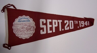
Souvenir - Pennant - Centenary, Portland, Connecticut, September 20th, 1941, 1941
Red felt pennant with painted lettering and a roundel depicting an early settlement by edge of a harbour with a sailing ship in it. Left edge is bound with white felt, and two red felt tags and sewn at top and bottom of white edging.Front: "CENTENARY / PORTLAND. CONN/ FIRST HOUSE IN PORTLAND, 1690" (in roundel). SEPT. 20TH, 1941 (white paint on centre of pennant). -
Glenelg Shire Council Cultural Collection
Banner - Banner - Civic Mementoes, 1984
Souvenir of Portland's 150th. White taffeta. Town Crest (blue/red/yellow) Red lettering - Town of Portland First Permanent Settlement of Victoria Blue Fringe. Gold cord hanger.Front: n/a -
Glenelg Shire Council Cultural Collection
Souvenir - Sticker - Portland 150th, 1984
Glenelg Shire Council Records dept.Oblong-shaped promotional sticker, promoting Portland's 150th celebrations in 1984. Black text printed on white background, plus logo of whale in triangle with blue green wave design.Front: Portland's 150th Anniversary 1934-1984 Victoria's First Permanent Settlementsticker, souvenir, 150th, celebration -
Glenelg Shire Council Cultural Collection
Newspaper - Newspaper - The Portland Observer, The Portland Observer, 19/11/1934
Two page Centenary Souvenir Supplement, to the Portland Observer, 19th Nov. 1934 Articles on Henty family, Captain William Dutton, story of Portland's settlement, whaling, list of chairmen, Portland municipality; black and white photos -
Glenelg Shire Council Cultural Collection
Photograph - Photograph - Portland's 150th Anniversary Celebrations 1984, 19/11/1984
In November 1984 Portland marked the 150th anniversary of European settlement and the foundation of the City of Portland. Various events happened in and around Portland, many community led. Syd Cuffe was the Portland Town Crier from 1983 to 2013. The role of Town Crier was created for Syd Cuffe in 1983 in the lead up to Portland’s 150th anniversary celebrations held in 1984-85. 200 items from Mr. Cuffe’s estate were donated to the Glenelg Shire Cultural Collection. The items relate to his town crying activities and community work across the Shire and further afield.Coloured photo. Two people sitting on cannon at Memorial Triangle, section of Cliff St. Portland's 150th Anniversary celebrationsportlands 150th anniversary celebrations 1984 -
Glenelg Shire Council Cultural Collection
Pamphlet, Historic Portland Buildings Open Day, 1970s
Camperdown and District Heritage Society, Collection.Two copies of black and white pamphlet to commemorate the first permanent settlement in Victoria, Historic Portland Buildings Open Day.Front: Black and white image of Gardens cottage Back: Black and white map of Historic Portland buildingshistoric buildings, buildings of portland, tourism, local history -
Glenelg Shire Council Cultural Collection
Souvenir - Medal, 1934
Circular copper medal with loop at top. Centenary of Portland on one side bust of Edward Henty in relief and the text 'To commemorate the 100th anniversay of the first settlement 1934-1934'. On the other side image of Lt. Grant on the 'Lady Nelson' and the text "Lieut. James Grant discovering and naming Portland Bay 1800'. -
Glenelg Shire Council Cultural Collection
Booklet, 'Portland Victoria's oldest European settlement is now .... Australia's newest cruise destination, 2011
12 Page promotional booklet to attract cruise ships to Portland. Includes information on attractions in and around Portland, history, Great Ocean Road and specifications of S.L. Patterson Berth where potential cruise ships would berth. Booklet made from light card; full colour; front has image of cruise ship superimposed on old view of Portland Harbour. -
 Glenelg Shire Council Cultural Collection
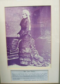
Photograph, Mrs. Jane Henty, 1984
Displayed at History House. Original presented by Edward Henty Smallpage to Stokesley in around 1934Black and white photograph of a standing woman in 19th century dress. Her dress is a dark colour and she is wearing a white cap with trailing lace/fabric back. She is posed in a room with floral wallpaper, standing behind a chair with her hands clasped in front of her. At bottom of frame are the details of the donation of this item. Framed under glass in wooden frame.Front: PRESENTED TO THE TOWN OF PORTLAND BY THE PARISH COUNCIL OF STOKESLEY, ENGLAND 1984 (typed, upper case). Mrs. Jane Henty, wife of the Hon. Stephen George henty, M.L.C. The first white woman in Portland, the earliest permanent settlement in the State of Cictoria, Australia. Born at Stokesley, 8th February 1817, daughter of Captain Walter Pace. Landed at Portland, June 1836. Died at Hamilton, Victoria, 3rd February 1906. This portrait is presented on the Centenary Anniversary of the foundation of Victoria, 19th November 1934, by her Great Grandson, EDWARD HENTY SMALLPAGE, M.B., Ch.M. (Syd), F.R.C.S. (Eng).henty, jane henty, portrait photography -
Glenelg Shire Council Cultural Collection
Photograph - Photograph - Portland High School Staff, 1984, c. 1984
In November 1984 Portland marked the 150th anniversary of European settlement and the foundation of the City of Portland. Various events happened in and around Portland, many community led.Staff of Portland High School, Portland's 150th Anniversary celebrations in 1984. Photo taken outside science wing, staff in period dressportland high school, education, secondary school, portland 150th anniversary -
Glenelg Shire Council Cultural Collection
Photograph - Photograph - Portland 150th Ball, c. 1984
In November 1984 Portland marked the 150th anniversary of European settlement and the foundation of the City of Portland. Various events happened in and around Portland, many community led.Portland 150th Celebrations, 1984. Photograph of a ball held in transit shed at the K.S. Anderson Wharf; table of guests from left to right: Stella Cugley, Julie Morrow, David Cugley, Mick Morrow, Roy and Di Jennings (obscured), Earl Ross, Marg Ross. All in period costumeportland 150th anniversary, ball, portland harbour, k s anderson wharf -
Glenelg Shire Council Cultural Collection
Clothing - Skirt - Portland 150th Anniversary, c. 1984
In November 1984 Portland marked the 150th anniversary of European settlement and the foundation of the City of Portland. Various events happened in and around Portland, many community led.Skirt, steel blue in colour, with black vertical stripes, 'shiny' fabric. Long, gathered waist, deep frill at bottom, decorated with black lace. Made for Portland's 150th celebrations in a period styleportland 150th anniversary, costume, womens dress -
Glenelg Shire Council Cultural Collection
Photograph - Photograph - Portland 150th Anniversary Ball, c. 1984
In November 1984 Portland marked the 150th anniversary of European settlement and the foundation of the City of Portland. Various events happened in and around Portland, many community led.Portland 150th celebrations ball which was held in transit shed at K.S. Anderson Wharf. Table of guests from left to right: Stella Cugley, Julie Morrow, David Cugley, Mick Morrow, Roy Jennings, Di Jennings, Earl Ross, Marg Ross, all dressed in period costumeportland 150th anniversary, k s anderson wharf, ball, celebration -
Glenelg Shire Council Cultural Collection
Photograph - Photograph - Syd Cuffe, Town Crier Portland 150th Celebrations 1984, 19/11/1984
Syd Cuffe was the Portland Town Crier from 1983 to 2013. The role of Town Crier was created for Syd Cuffe in 1983 in the lead up to Portland’s 150th anniversary celebrations held in 1984-85. 200 items from Mr. Cuffe’s estate were donated to the Glenelg Shire Cultural Collection. The items relate to his town crying activities and community work across the Shire and further afield. In November 1984 Portland marked the 150th anniversary of European settlement and the foundation of the City of Portland. Various events happened in and around Portland, many community ledColoured photo. Group of people, vintage car, steam engine and carriages. Portland's 150th Anniversary celebrations 1984.portland 150th celebrations -
Glenelg Shire Council Cultural Collection
Photograph - Photograph- Syd Cuffe, Town Crier Portland's 150th Anniversary Celebrations 1984, 19/11/1984
In November 1984 Portland marked the 150th anniversary of European settlement and the foundation of the City of Portland. Various events happened in and around Portland, many community led. Syd Cuffe was the Portland Town Crier from 1983 to 2013. The role of Town Crier was created for Syd Cuffe in 1983 in the lead up to Portland’s 150th anniversary celebrations held in 1984-85. 200 items from Mr. Cuffe’s estate were donated to the Glenelg Shire Cultural Collection. The items relate to his town crying activities and community work across the Shire and further afield.Coloured photo. Transit shed, K.S. Anderson wharf set up for Portland's 150th Anniversary celebrations ball.portlands 150th anniversary celebrations 1984 -
Glenelg Shire Council Cultural Collection
Photograph - Photograph - Syd Cuffe, Town Crier, 19/11/1984
Syd Cuffe was the Portland Town Crier from 1983 to 2013. The role of Town Crier was created for Syd Cuffe in 1983 in the lead up to Portland’s 150th anniversary celebrations held in 1984-85. 200 items from Mr. Cuffe’s estate were donated to the Glenelg Shire Cultural Collection. The items relate to his town crying activities and community work across the Shire and further afield. In November 1984 Portland marked the 150th anniversary of European settlement and the foundation of the City of Portland. Various events happened in and around Portland, many community led.Coloured photo. Pipe band marching down Julia St. Portland's 150th Anniversary celebrations.portlands 150th anniversary celebrations 1984 -
Glenelg Shire Council Cultural Collection
Photograph - Photograph- Syd Cuffe, Town Crier Portland's 150th Anniversary celebrations, parade 1984, n.d
In November 1984 Portland marked the 150th anniversary of European settlement and the foundation of the City of Portland. Various events happened in and around Portland, many community led. Syd Cuffe was the Portland Town Crier from 1983 to 2013. The role of Town Crier was created for Syd Cuffe in 1983 in the lead up to Portland’s 150th anniversary celebrations held in 1984-85. 200 items from Mr. Cuffe’s estate were donated to the Glenelg Shire Cultural Collection. The items relate to his town crying activities and community work across the Shire and further afield.Coloured photo. Syd Cuffe and others on float, Portland's 150th Anniversary celebrations, parade 19 NOV 1984. -
Glenelg Shire Council Cultural Collection
Souvenir - Souvenir Medallion - Portland 150th Anniversary 1984, Brim Medallions, Melbourne, c. 1984
In November 1984 Portland marked the 150th anniversary of European settlement and the foundation of the City of Portland. Various events happened in and around Portland, many community led. Syd Cuffe was the Portland Town Crier from 1983 to 2013. The role of Town Crier was created for Syd Cuffe in 1983 in the lead up to Portland’s 150th anniversary celebrations held in 1984-85. 200 items from Mr. Cuffe’s estate were donated to the Glenelg Shire Cultural Collection. The items relate to his town crying activities and community work across the Shire and further afield.Medallion, silver, Portland 150th Anniversary 1984, whale and triangle logo, reverse, Victoria 150th, Growing Together 1984 -1985, with logo. In clear plastic pocket. Medallion measures 5 cm diameter x 0.4 cm deepportlands 150th anniversary celebrations 1984