Showing 65 items
matching south crescent
-
 Eltham District Historical Society Inc
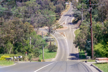
Negative - Photograph, Looking south along Ryans Road towards intersection with Kerrie Crescent, Eltham North, c.1998
Taken from opposite intersection with Elm CrescentRoll of 35mm colour negative film, 8 strips and associated 10 x 15 cm colour printKodak Gold 100-5elm crescent, eltham north, kerrie crescent, ryans road, streets -
 Glen Eira Historical Society
Document - CUMBERNAULD
This file contains nine pages about people related to this property: 1/Copy and pasted eight pages taken from Census Records and Trove items. Articles include the death of Thomas Livingstone Cleland during WWI. Various social notes regarding his family up to 1953. There are articles on the W.J. Mathieson family, who also resided there, as well as residing in Benalla. 2/Print from Trove of an article from the 23/11/1934 edition of The North Eastern Ensign (Benalla, Vic) about the wedding anniversary of Mr and Mrs W.J. Mathieson, held at Cumbernauld on 27/10/1934.cumbernauld, thornleigh grange, house names, cleland thomas livingstone, cleland annie, gardeners market, clayton road, ‘hillside’, caulfield, anderson street, cleland sydney, cleland margaret, cleland james, cleland adelaide, cleland robert, cleland bessie adelaide, cleland agnes, cleland lily, cleland alick douglas milkman, cleland aggie, cleland tom h.s. draftsman, cleland kenneth malcolm, cleland ethel, cleland hector, cleland edna may, mathieson w.j., mathieson isabel, burrows f.a. lieut., east st. kilda, hawthorn road, ‘thornleigh grange’, south caulfield progress association, south caulfield junction, caulfield court, jenkins harry, giles alfred, grafton street, elsternwick, dawes john, chloris crescent, st. john’s presbyterian church, mathieson evelyn mary, marks theodore leslie, mathieson kitty, masonic hall, st. george’s road, haverfield frank, haverfield mrs, haverfield robert ross, rynn mary buckley, cyclists, cycling, donald alexander, martin lottie, whitelaw joan, trinity hall, brighton road, gilmore patricia phyllis, brooklyn ave., point nepean road, north road, brighton court, cleland nora, seaview drive, cleland john stuart, mathieson isabella cristina, kalymna grove, mathieson catherine m., tailor, mathieson william james, councillors, social events and activities, births deaths and marriages, anniversaries, world war 1914-18, soldiers -
Glen Eira Historical Society
Ephemera - SHELFORD GIRLS’ SCHOOL AND KINDERGARTEN
This file contains 7 items relating to advertising for the school and its events: 1/1 2 page advertisement for Shelford, dated February 2010, from an unknown publication. 2/1 1 page advertisement for Shelford Scholarships from ‘DUX 2010’, South Edition, published by Leader News. 3/1 advertisement for Shelford tours and the opening of the Performing Arts Precinct 03/04/2011, published in the ‘Melbourne Weekly Bayside’ 23/03/2011. 4/1 advertisement for Shelford tours and the opening of the Performing Arts Precinct 03/04/2011 published in the ‘Caulfield/Port Phillip Leader’ 29/03/2011. 5/1 advertisement advertising Shelford school and its upcoming events, published in the ‘Melbourne Weekly Bayside’, 11/05/2011. 6/1 advertisement advertising Shelford school and its upcoming events, published in the ‘Caulfield/Port Phillip Leader’, 17/05/2011 7/1 advertisement for Shelford school from ‘DUX 2011’, South Edition, published by Leader News.education, schools, shelford, music, sport, shelford girls’ school and kindergarten, art, anglican church, hood crescent, caulfield, ciolli judy, theatres, dillon paul, walker kathy, drama, tertiary education, secondary education, secondary schools, primary education, preschool education, advertisements, advertising -
Glen Eira Historical Society
Document - Racing Stables In Caulfield
This file contains 3 items. 1/ Document provided by Veterinarian Dr G. G. Heslop about racing stables in the Caulfield area adjacent to the Caulfield Race Course, in both typed and handwritten form. 2/ A letter of request from a Sydney based sports writer Geoff Armstrong for information about the attempted shooting for Phar Lap. 3/ A letter to the Editor in the Glen Eira/Port Phillip Leader dated 02/04/2013 about the proposal to ban horse training from the Caulfield Racecourse.clubs and associations, victorian amateur turf club, racecourses, caulfield race course, racecourse trainers, stables, racehorses, schools, secondary school, caulfield high school, hotels, caulfield club hotel, wattle tree hotel, petrol stations, veterinarian clinic, norman myers veterinarian hospital, baker norma, bence j., bird j., cadby lou, conaghan basil, cameron ron, couseng harry, cox cecil, creighton norman, delaney g., eules darce, farmer h. (dick), fraser mick, foulsham fred, fryer j., gatell harry, garton a. (rod), garland f., godby cecil, godby frank, goodfellow claude, guinane p., hayes t. j., hilton h., hodgkinson george, james jack, jenkins e. j., jennings reg, judd des, jury jack, king frank, mcgregor j. n., mcnamara dave, mcphee sonny, mclaughlin, mulcahy j., murphy geoff, muskett j., parkinson j., phillipson mr., quinlan pat, ralph stan, reid stanley, robinson f., rolfe w. j., sanderson chris, telford w., tie jerry, torr harry, bernborough, black caviar, garryowen, phar lap, purser, revenue, spearfelt, surround, arthur jr., murrel violet, farmer violet, kemball w. r., mcdonald leslie, brockhoff mr., carslake mr., gullifer h., heywood j. g., llord mr., davies mr., palfreman mr., caulfield, caulfield north, caulfield south, carnegie, glen huntly, glenhuntly, eskdale road, balaclava road, bambra road, glen eira road, heywood street, hudson street, hawthorn road, kambrook road, kooyong road, tudor court, lloyds paddock, payne street, park crescent, service street, slaney’s paddock, station street, booran road, ‘moidart’, cadby court, glen huntly road, glenhuntly road, neerim road, ‘cintra’, stephen street, uranda line grove, willgra road, epsom street, lloyds street, lord street, queens avenue, st vincents street, roseberry grove, manchester grove, safeway supermarket, hesop g. g. dr veterinary surgeon -
Glen Eira Historical Society
Article - Rosstown Railway
This file contains three items: 1/A review of the ROSSTOWN RAIL TRAIL from LIVING IN GLEN EIRA, vol. 11, 2004, Issue 4, no. 25, date and author unknown. The review explains the purpose of the Rail Trail with a brief narrative of the history behind Rosstown Sugar Mill Railway line. Concluding with information on the location of the Trail and the expected time required to walk the entire track included in the review is a map of the Rail Trail, which marks significant sites along the trail with historic pictures. 2/A newspaper article from THE AGE, dated Tuesday 21/10/1980 and written by Iola Matthews, reporting on the circumstances that led to the publication of the book RETURN TO ROSSTOWN written by Des Jowett and Ian Weickhardt. The article begins with a brief biography of the authors before moving into details of the book’s content, providing a further biography of W. Murray Ross which includes information on his financial ventures – particularly the Rosstown Rail – his marriage and children. The article includes a black and white photograph of Weickhardt and Jowett walking along the route of the railway line, an illustration of the Rosstown sugar works and a map of the area surrounding the site of the mill. 3/Three photocopies of a black and white illustration of the Rosstown sugar works from the east, undated and artist unknown.rosstown rail trail, rosstown, ross william, ross w. murray, ross murray, sugar beet mills, mills, elsternwick, land transport, railways, railway lines, railway routes, carnegie neville street, carnegie miller street, factories, market gardens, horticulture, peat, soils, land forms, topography, geology, civic issues, cone sugar industry, elsternwick plaza, elsternwick, glenhuntly road, parks and reserves, ee gunn reserve, caulfield racecourse, sportsgrounds, caulfield, carnegie, riddell parade, clarence street, aileen avenue, princes park, dover street, marara road, oakleigh road, rosanna street, murrumbeena crescent, north road, kooyong road, hawthorn road, booran road, koornang road, poath road, warragul road, railway platforms, railway buildings, bambra road, swamps, landforms, landfill, council landfill, railway bridges, bridges, railway underpasses, sporting clubs, tennis clubs, bowls clubs, rosstown railway, rosanna street reserve, maps, railway maps, living in glen eira, weickhardt ian, jowett des, caulfield south, curraweena road, oakleigh, caulfield technical school, return to rosstown, beet sugar industry, crops, land booms, land development and subdivisions, bent thomas, fink benjamin, sugar works, rosstown hotel, oamdenong road, rosstown dry cleaners, shops, rosstown road, rosstown plate, people by circumstance, migrants, accountants, occupations, professionals, the grange, real estate, grange road, financial agents, judges, rosstown estate, financial trouble, rabbit preserving, breweries, political debates, political issues, political electorates, politics, political science, debt, financial loans, court procedures, court cases, legal events and activities, malleson and riggall, widowers, seabeach railway, economics, economic deadline, depression 1890s, economic crash, mortgages, divorce, social problems, poverty, ross claude, ross roderick, world war 1914-1918, wars, military history, servicemen, australian flying corps, engineers, caulfield council, swagmen, homelessness, glenhuntly road, glenhuntly road tram, woornack road, leila road, wild cherry road, melten avenue, illustrations, steam trains, trains, horse and cart, horse-drawn transport, railway stations -
 Glen Eira Historical Society
Document - Dairies
This file contains six items: 1/Handwritten information from 1874 Sands & McDougalls sent to Mr. P Murray in 26/05/1977 from Miss IV Anderson/ 2/Typed pages from Sands & McDougalls, 1911, 1913, 1942 editions dairy entries. 3/Four separate receipts, one photocopied of local dairies, various dates. 4/Two black-and-white photographs of Archibald Short, proprietor of Shorts Dairy in Carlingford Street, and resided in College Street, Elsternwick. 5/Printed document taken from Purchase Agreement between Clara Benzley and Thomas Jenner, on the purchase of a dairy at 43 Woornack Road. Carnegie 13/08/1926. Gives the items included in contract of sale, including 2 horses. 6/Caulfield Glen Eira Leader newspaper article dated is May, 2014, showing upcoming sale of 43 Woornack Road, Carnegie. The property was Clara Benzley’s (granddaughter Claire Barton) dairy in 1926.burlington model dairy, glen huntly road, caulfield, hall mr., carinya dairy, orrong crescent, bradin, rice l. i., dairyman, green r., queens ave., carnegie, neerim road, parton’s dairy, hawthorn road, short archibald, carlingford street, south caulfield, college street, elsternwick, milk cart, dairying, dairies, land sales, real estate, architectural, woornack road, auctions -
Glen Eira Historical Society
Document - GLEN HUNTLY (HISTORY OF)
This file contains one item: 1/A loose-leaf, 23-page document titled ‘The History of Glen Huntly’, by Alfred R. Jones, dated 20/06/1991, describing the history of the suburb. The author has drawn heavily from the 4 sources noted in the bibliography. Subjects covered include the ship the suburb is named after, the suburb’s State School, the suburb’s churches, the Rosstown Railway and Sugar Mill, the origin of the name of Carnegie, the suburb’s aerodrome, and the beautification of the Glen Huntly Shopping Centre. The final 12 pages consist of 9 appendices relating to the aforementioned subjects. Appendix A is a typewritten letter from Ron McLeod, secretary of the Place Names Committee, to Mr. D. R. Aylen, CEO of the City of Caulfield, notifying the latter of the alteration of the name ‘Glenhuntly’ to ‘Glen Huntly’. Appendix B is a list of the ministers of St. David’s Uniting Church from its formation in 1916 to the present. Appendix C identifies the persons portrayed in St. David’s stained glass windows. Appendix D is a poster announcing the auction of 41 blocks of land between Hawthorn and Bambra Road formerly owned by William Ross, plus a map identifying said land blocks and anither fir locality. Appendix E is an A4 plan of the Rosstown Railway. Appendix F is a drawing of the Rosstown Sugar Mill. Appendix G is a poem titled ‘The Swagman’s Retreat’, by Herb Arnott, about the failure of the Mill. Appendix H is a map of Caulfield’s horse tramways plus a list of opening and closing dates. Appendix J is a list of streets explaining the meanings of their names.glen huntly, glenhuntly, local history, ‘glen huntly’ (ship), ‘glen huntlely’ (ship), quarantine stations, glen huntly road, lake street, mernda avenue, glen huntly state school no. 3703, ormond francis, ormond, garden avenue, grange road, churches, congregational church, glen huntly presbyterian church, st. david’s, st. david’s uniting church, anglican church, jenkin william ‘boss’, methodist church, wattle avenue, smith a. w. mr., glen huntly post office, glen huntly road, king f. l. mr., uniting church, child care centre, presbyterian church of eastern australia, glen huntly methodist church, sun aria, miller mary, stained glass, phrenologists, trinity congregational church, primitive methodists, ‘the victorian independent’, mercy mr., greek orthodox original old calendar church, wanalta road, salvation army, halls, myrtle street, catholic church, st. anthony’s roman catholic church, foundation stones, neerim road, mannix archbishop, st. agnes’ anglican church, booran road, sunday schools, clergy residences, ‘see’ anglican news magazine, lees archbishop, booth archbishop, glen huntly presbyterian church, el nido grove, tennis courts, bollard v. w. right rev., waratah avenue, royal avenue, munster avenue, james street, rothschild street, peace memorial organ, singers, bremner marie, scotland betty, carden joan, rosstown railway, south caulfield, plants, marata road, curraweena road, bambra road, ross william murray, ross leila, ross constance, vautin constance, ‘the grange’, north road, leila road, wild cherry road, caulfield roads board, elsternwick, land sales, sugar mills, koornang road, woornack road, elsternwick railway station, riddell parade, clarence street, dover street, oakleigh road, murrumbeena crescent, carlisle crescent, railways, trains, parks and reserves, caulfield council, sussex street, caulfield city council, swamps, rosstown sugar mill, rosstown estate, ‘the swagman’s retreat’, arnott herb, rosstown, carnegie, ‘ross’s folly’, carnegie andrew, rosstown hotel, dandenong road, rosstown road, rosstown plate horse race, caulfield racecourses, ames avenue, rosstown court, hostels, murrumbeena, cinemas, innovations (cabinetry film), films, music, pianos, manchester grove, safeway store, squash courts, airports, lord reserve, aeroplanes, air navigation act 1921, neville street, larkin sopwith aviation company of australasia, lyons street, morgan street, bookmakers, nightsoil, poultry, weatherboard buildings, glen huntly railway station, rosedale avenue, rifle clubs, scout groups, 1st glen huntly troop, ana, dowding jack mr., glen huntly infant welfare and family planning clinic, vermador private hospital, watson grove, rowlands (drapers), bones plant nursery, caulfield railway station, bridges, trams, horse tramways, glen eira road, elsternwick railway station, kooyong road, aboriginal peoples, truganini road, hannan lyn mrs. (urban planning officer), glen huntly shopping centre, sculptures, street beautification scheme, “flying the yellow flag”, moore olive, “return to rosstown”, jowett d. f., weickhardt i. s., “from sand swamp and health”, murray peter r., wells john c., caulfield historical society, newsletters, place names committee, mcleod ron, aylen d. r. mr., jones hugh rev., king joseph, scarfe james, vertigan sidney, vertigan earle, rance victor, flavell cameron, denholm robin, moorhead ken, taliai siupeli, eccles james leslie, little agnes, hutchins william r., dickie may a., gordon ivey agnes, theobald a. a. mrs., brownbill lloyd norman, ash georgette, land sales, auctions, messrs. crews & arkle, street names -
Glen Eira Historical Society
Letter - HISTORIC BUILDINGS REGISTER
This file contains 3 items: 1/A register of historic buildings in Caulfield dated 29/06/1978 2/A copy of the Historic Buildings Register from the Historic Buildings Council Victoria (current as at 22/10/1982. The copy has a business card attached with a handwritten note to ‘Dick/thought you might find this of use. Bernie’, from Bernard C. Carroll, the Senior Records Officer at Caulfield City Council. The accompanying letter is dated 17/01/1983 and stamped Caulfield Historical Society. 3/Two letters of correspondence to and from the Historic Buildings Council dated 26/10/1983 and 14/12/1983. It regards the application for Rippon Lea to be added to the Register of Historic Buildings.rippon lea, hotham street, elsternwick, caulfield, caulfield south, caulfield north, city of caulfield, caulfield city council, bernard c. carroll, bernie carroll, halstead street, halstead, poplar grove, athole, caulfield historical society, glenfern, inkerman street, craigellachie, orrong road, elsternwick club, sandham street, bambra road, balaclava road, glenferrie street, labassa, manor grove, lirrewa, lirrewa grove, lisbon house, myoora, alma road, hopetoun gardens, st. mary’s jubilee school, glen eira road, hood crescent, st. stephen’s presbyterian church, st. stephen’s pres. church, trinity congregational church, trinity congreg. church, grange road, bellecourt, seymour road, elsternwick congregational church, elst. congreg. church, st. georges road, glenmoore, grimwade house, orrong crescent, glenhuntly road, glen huntly road, state school no. 773, st. mary’s church of england, sandham street, selwyn street, former met. fire brigade station no. 31, presentation convent, o’neill college, nagle avenue, methodist church, neerim road, heatherbrae, elizabeth street, craddock avenue, rosecraddock, stables, tram shelter, city hall, civic establishments, local history, clubs and associations, historic buildings, registers, official buildings, local officials and employees -
Glen Eira Historical Society
Document - Glen Eira Residents Association
Six items pertaining to Glen Eira Residents Asssociation Inc. 1/Two copies of the minutes of a Committee Meeting of Glen Eira Residents Association Inc., held on 04/12/2001. The minutes cover a range of routine meeting items, as well as the postponed release of the Princes Park Master Plans and the proposed construction of car parks at Caulfield Racecourse. 2/A copy of Glen Eira Residents’ Association Inc.’s 30/05/2003 newsletter, notifying members of matters presently before Glen Eira City Council for purposes of evaluation. Matters include an admonishment to the Council to sort out anomalies between the C25 Amendment (80/20 Plan) and the Melbourne 2030 Plan, the success at convincing the Ministerial panel to adopt GERA’s views regarding the C14 Council Plan for the Caulfield Racecourse, a request for information from the Council regarding the previous year’s rate increase, a request for information from the Council regarding spending on planning for improvements to Princes Park, a call for the Council to improve its consultative procedures, a recommendation that the purpose of Glen Eira News be expanded to the making of suggestions for city improvement, and a notification of the measures implemented to improve the visibility of Caulfield Racecourse’s usability by the public. Includes a black-and-white photograph of Orrong Road, Elsternwick, illustrating what Glen Eira’s roads would look like if lined with trees, which was excluded from Glen Eira News on account of a current prohibition on the making of suggestions for city improvements. 3/Four copies of a booklet entitled ‘A Short Guide to Planning Procedures’, composed 08/2006, which endeavours to explain, as concisely as possible, the methodology by which Glen Eira City Council approves real estate developments and issues planning permits. 4/A booklet containing the minutes of the 05/10/2009 Annual General Meeting of Glen Eira Residents’ Association Inc. Details both routine items and more specific matters of discussion, such as inappropriate charges on the part of the Glen Eira City Council and the proposed inception of a questionnaire to evaluate local residents’ opinion of the Council. 5/A booklet announcing the 07/10/2010 Annual General Meeting of Glen Eira Residents’ Association Inc. at St. John’s Uniting Church, Elsternwick. Front cover details agenda and contains four colour photographs pertaining to public transport (buses, trams, trains) within the city. Interior features president Don Dunstan reflecting on issues relevant to GERA occurring over the preceding twelve months, with an emphasis on the dubious behaviour of the City Council, as well as two colour photographs: one of Dunstan himself and one of traffic at Elsternwick Junction. The rear cover contains the Financial Statement presented to the Meeting. 6Two copies of a printout of an article from the website of Glen Eira Residents’ Association Inc., accessed 19/06/2012, explaining the affects wrought as a result of the implementation of Planning Scheme Amendment C87. Said amendment changes the Planning Scheme protecting neighbourhood character by replacing the previous Significant Character Area (SCA) designation with the new designations of Neighbourhood Character Overlay (NCO) and Design and Development Overlay (DDO). In developing the Amendment, Glen Eira City Council commissioned Planisphere to procure the Planisphere Final Report, in which recommendations regarding the expansion, creation and deletion of SCAs were offered. The article contains a summary of said recommendations.glen eira residents’ association inc., clubs and associations, glen eira, meetings, minutes, campbell jack, dunstan don, marwick geoff, pleydell max, teseriero dominic, robins kevin, princes park, south caulfield, glen eira city council, local government, councillors, brennan martin, victorian local government association (vlga), erlich mayor, project manikato, caulfield racecourse, caulfield racecourse flat, racecourses, parks, car parks, kennedy cr., kennedy norman mr., crown land, glen eira road, rippon lea, c25 plan (80/20), melbourne 2030 plan, c14 council plan, rates, orrong road, elsternwick, trees, station street, caulfield north, neerim road, glenhuntly, glenhuntly park, orrong ward, grossbard cr., martens cr., building permits, delegated planning committee (dpc), steward joy, brohier peter, campbell fliss, scutt alex, ray darren, hannah brian, st. john’s uniting church, mees paul dr., elsternwick club, sandham street, melbourne weekly bayside, glen eira debates, walsh investigation, whelen investigation, forge cheryl cr., whiteside helen mayor, save our suburbs (sos), walsh mary, walsh kevin, french christine, elsternwick junction, planning scheme, planning scheme amendment c87, significant character areas (scas), planisphere final report, oakdene crescent, carnegie, blackwood street, housing diversity areas, urandaline grove, caulfield, normanby road/park crescent, kambrook road, balaclava road, hawthorn road tramway estate, caulfield south, ulupna road, ormond, murray street, prentice street, kambea grove, chestnut street, mcpherson avenue, queens avenue, caulfield east, derby crescent, clarinda street, st. james parade/downshire road, exhibition street, mckinnon, field street, boyd park, murrumbeena, lindsay avenue, lydson street -
Glen Eira Historical Society
Newsletter - GARY PEER AND ASSOCIATES 2005
This file contains one item. The Autumn 2010 newsletter (six pages) of Gary Peer and Associates a real estate business based in Caulfield North. The newsletter, as well as containing information about Gary Peer and Associates and its staff also features fifteen small colour photographs of properties sold or rented including nine properties in the Glen Eira area. Under some of the photographs are a brief comment on the circumstances of sale, such as the number of bidders. Also included is a feature on the business ‘Texas Flower Rangers’ based in William Street, Balaclava, with a colour photograph of owners Linda and Rob Kras.gary peer and associates, krongold hayley, william street, peer gary, zelman sally, balaclava, kingston phillip, texas flower rangers, inkerman road, caughey jenny, kras linda, caulfield north, krongold darren, kras rob, raynes street, caulfield south, wild cherry road, ormond, balaclava road, clee street, mckinnon, muntz street, rose craddock place, wilks street, turner avenue, glen huntly, orrong road, orrong crescent, real estate agencies, real estate agents, property developers, auctions, leases, newsletters, florists -
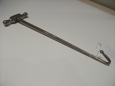
 Flagstaff Hill Maritime Museum and Village
Tool - Brace & Bit, John S Fray, 1883 - 1906
Context: A brace is a hand tool used with a bit (drill bit or auger) to drill holes, usually in wood. The pressure is applied to the top and the tool is rotated with a U-shaped grip. Bits used to come in a variety of types but today the more commonly used Ridgeway and Irwin pattern bits also rely on a snail point (called the snail), which is a tapered screw point shaped the same as a wood screw thread, which helps to pull the bit into the wood as the user turns the brace handle and applies pressure. The designs used today come from an original idea and pattern invented by John S Fray. Company History: John S. Fray (1833 ) immigrated to Bridgeport Connecticut USA from England in the 1850s and established a working relationship with Nelson Spofford, who held an 1858 patent for a bit brace (the tool could be augured in a continuous circular motion by hand). He established the John S. Fray Co. around the same time and immediately began producing the Spofford bit brace. Fray himself held at least two patents: one awarded in 1869 for a boring brace attachment, and another awarded in 1883 for a tool handle. By 1889, the firm was located at the industrial complex that sits between the former International Silver Company and the former Bridgeport Chain Company on Crescent Avenue and is identified on the Sanborn Insurance Atlas as a manufacturer of Spofford bit braces, hollow handle awl, and toolsets. The company was in competition with Peck Stow and Wilcox Co. of Southington, and in 1898 was enjoined from making a ratchet bit brace for which the latter company held a patent. By the 1920s, the factory had been purchased by the Stanley Company of New Britain and leased to the American Tube and Stamping Company, a manufacturer of brass, copper, seamless, and bicycle tubing, which also ran a rolling mill to the south on Stafford Avenue (now demolished). The Stanley Company bought both mills in 1926, perhaps as a strategic move to be located along the Bridgeport Harbour, through which much of the raw material used in its operations throughout the state came. By the 1950s, the Crescent Avenue operations had been moved to other sites in Connecticut, and Stanley again leased the building to a company called Cornwall and Patterson, a manufacturer of piano hardware. Today the building appears to be vacant. An early carpenters tool made by a well known early manufacturer from America who instigated many innovations to the making of tools. His early pattern for the improvement of a tool that could be used for the boring of holes in wood was a significant step forward. His design for a boring brace attachment and later a specific handle is still in use today and his original brace and bit is now sought after by collectors of antique tools. Spofford Carpenter's Bit Brace metal has bit attached. Wing nut holds bit in place but nut missing. holds bit in place. 285mm long x 160mm Noneflagstaff hill, warrnambool, shipwrecked-coast, flagstaff-hill, flagstaff-hill-maritime-museum, maritime-museum, shipwreck-coast, flagstaff-hill-maritime-village -
 Yarra Glen & District Historical Society
Black and white photographs, House and post office owned by John Hicks Petty 1866
Built in 1861 on the south side of Symonds Street opposite Irvine Crescent this building was the home of John Hicks Petty. He operated the first Post Office in Yarra Flats from here. Mr Petty, holding a baby, is standing alongside his wife Maria Louisa Petty. The cottage is built of sawn timber, placed vertically, and a shingle roof. There is an established garden surrounding the house with creeper climbing the walls.post office, original post office, john hicks petty, maria louisa petty, symonds street, irvine crescent, shingle roof, timber house, cottage garden, baby, yarra flats post office, yarra flats -
 Federation University Historical Collection
Book, The Old Pioneers' Memorial History of Melbourne From the Discovery of Port Phillip to the World War, 1924
Blue hard covered book of 494 pages. Images, and a large plan of prominent burials in the Melbourne Old Cemetery, and a Map of Melbourne. melbourne, melbourne cemetery, melbourne old cemetery, john batman, edmund hobson, batman's map, st francis' church, james balfour, mrs hornbrook, paddy's market, wilson hall, working men's college, henry kendall, le souef's cottage, world war one, westernport, melbourne cup, hoddle, collingwood, south melbourne, prahran, richmond, kew, brunswick, coburg, preston, hawthorn, camberwell, nunawading, doncaster, st kilda, brighton, sandringham, cheltenham, caulfield, oalkleigh, footscray, sunshine, north melbourne, carlton, ballarat school of art library, ballarat technical art school, book plate, library plate, hume and hovell's overland journey 1824-5, major mtichell's overland journey, australia felix, booplate, aborigine, aboriginal, captain cook, arthur phillip, isaac smith, george bass, matthew flinders, john murray, catain baudain, captain collins, edward henty, portalnd, map od melbourne in 1938, john pascoe fawkner, the "enterprise: and fawkner's first home, old colonists' homes, rushall crescent north fitszroy, richard bourke, the old melbourne post offfice, old governmnt house, toorak, latrobe's house at jolimont, first melbourne land sale, melbourne water supply, peter henry smith, victorian legislative council opening, map of melbourne and collingwood, prince's bridge, crossing the rivers by punt, f.a> rucker, canvas city emerald hill, arrival of the gold escort in melbourne, the yarra, queen's wharf, tall ships, old st james, mary e. budd, st francis church, michael carr, meolbourne city mission, state library of victoria, melbourne public library, bourke street, angus mcmilan, methodist ladies college, ormond college, armistance celebrations, robert russell, mia mia, theatre royal bouke st, melbourne from flaggstaff hill, federal coffee palace collins st, lord melbourne, melbourne mint, old melbourne town hall, robert russell's melbourne and yarra falls, mandevalle hall, point lansdale lighthouse, wilson's promontory, margaret m. ward cole, williamstown, flinders st melbourne, queenscliff battery, broadmeadows soldiers' camp, embarkation of first troops on the 'ceramic', general monsash, ian hamilton, general bridges, victorian war memorial, national war memorial, st kilda pier, first melbourne cup, hoddle's grid, albert park, melbourne mechanic's institute, st kilda toll gate, munted policeman, springthorpe memorial, james bonwick, mornane's paddock, victorian railways melbourne and surburban lines, carlton gardens, thomas napier, wiliam westgarth, george augustus robinson, william lonsdale, elizabeth mary batman, peomena frances darling batman, dig tree, exhibition of 1854, exhibition of 1866, exhibition buildings, geelong harbour, jubilee lake, port campbell, warrnambool, queenscliff lightboat, batman's first house -
 Ringwood and District Historical Society
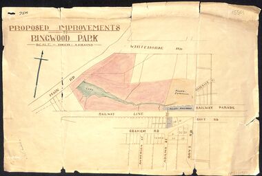
Map, Proposed Improvements to Ringwood Park (Ringwood Lake) dated 14 January 1927
Proposed Improvements to Ringwood Park (Ringwood Lake) dated 14 January 1927, signed Cr McCaskill. Main Road is Whitehorse Road (Maroondah Highway), and Mt Dandenong Road is incorrectly labelled Whitehorse Road. The map shows Rosedale Crescent and Railway Parade, both of which exist in 2024. On the bottom of the map, south of the railway line, showing proposed streets - Graham Road, Anderson Street and Adams Street - in preparation for the sale of the Theo Anderson property. That area is now Bedford Park. -
 Royal Australian and New Zealand College of Obstetricians & Gynaecologists (RANZCOG)
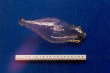
'Liptight' infant feeding bottle, National, U.K
Purchased from an Antique shop in Willunga, South Australia by Dr Malcolm Barnett, who then donated it to the collection.Glass feeding bottle. Bottle is loosely banana shaped, with a wider section in the middle narrowing to a neck at either end. The bottle has a flat base and is embossed with the word "Liptight" at top."LIPTIGHT"infant feeding, infant care -
 Royal Australian and New Zealand College of Obstetricians & Gynaecologists (RANZCOG)
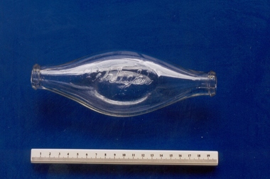
'The Sitar Feeder' infant feeding bottle, c. 1940
Purchased from an antique shop in Willunga, South Australia by Dr Malcolm Barnett, who then donated it to the collection.Glass feeding bottle. Bulbous glass bottle with openings at either end. The upper surface is rounded, and the bottom surface is angled to allow the bottle to sit on a flat surface. The upper end has a wider neck suitable for a rubber teat, whilst the lower end is narrower and may have had a valve attachment. Graduated measurement markings for tablespoons and ounces run along each side of the bottle. Embossed writing on underside of bottle reads "REG NO/47457", and on upper side reads "THE/SITAR/FEEDER/8 OZ/OR/225 ML".'THE/SITAR/FEEDER"infant feeding, infant care -
 Royal Australian and New Zealand College of Obstetricians & Gynaecologists (RANZCOG)
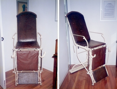
Examination chair associated with the Faculty of Anaesthetists, Royal Australian College of Surgeons, c1900
Likely to be a German designed operating chair. Very similar to operating chair shown in [Aesculap] Aktiengesellschaft fur Feinmechanik vormals Jetter & Sheerer, "Illustriertes Musterbuch", 1904, Tuttlingen, South Germany, p. 720, no. 34, 412 Fig 1 & 2. Early twentieth century examination chair constructed of metal and leather. The structure is metal and painted with cream enamel. The seat and seat extension are covered in brown leather. It has two folding sections with metal leg rests, and a base on castors. There are three holes in each arm rest, possibly indicating missing attachments. The chair is adjustable to horizontal.examination, furniture, royal australian college of surgeons -
 Royal Australian and New Zealand College of Obstetricians & Gynaecologists (RANZCOG)
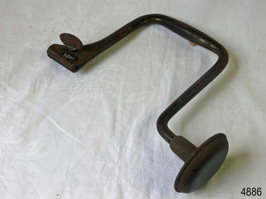
Decapitating hook, Braun's
Most likely collected and donated by Dr Frank Forster.Decapitating hook, Braun's with one detachable handle (to interchange with crochet?) . Stamped near handle, "Lusztig Jeno Budapest" and "1" Also stamped with Aesculapius symbol of serpent, dagger and crown, the Jetter & Scheerer Co, Tuttlinen, South Germany.obstetric delivery, destructive instrument, decapitating hook -
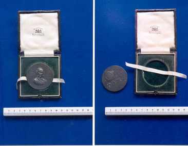 Royal Australian and New Zealand College of Obstetricians & Gynaecologists (RANZCOG)
Commemorative Lister Memorial Oration medal presented to Dr George Rothwell Adam, 1922, Spink & Son Ltd, 1922 (approximate)
This medal was awarded to Dr George Rothwell Adam, who was a lecturer in Obstetrics at the University of Melbourne from 1899 to 1913. As part of receiving this award, Adam delivered a Listerian Oration entitled ' The influence Listerism exercises on obstetrics' at a meeting of the South Australian Branch of the British Medical Association on May 25, 1922. "This Oration and Medal was established by the South Australian Branch of the British Medical Association in 1914. The first Oration was delivered on Thursday, June 25th of that year. On that day, the new premises of the Branch was opened. Subsequently, this annual Oration became recognized as the most important scientific event in the calendar of branch Scientific Meetings. In 1948 it was delivered by one of South Australia’s famous sons, Sir Hugh Cairns. There has been no Lister Oration since 1979. The obverse of the Lister Medal shows a portrait of Lord Lister 1827-1912, and on the reverse is inscribed ‘British Medical Association, South Australian Branch, Lister Oration’. Wood Jones’ Lister Oration 1926 ‘Before a large attendance of members of the South Australian branch of the British Medical Association at Lister Hall, Hindmarsh Square [Adelaide] on Thursday evening [May 27thl Professor F. Wood-Jones, F.R.S. of the Adelaide University, was heard with close attention during his lecture on “Disease and Individuality ’ ’. ’" from Frederic Wood Jones - his academic medals and those they honoured by B. E. Christophers, Aust. N.Z. J. Surg. (1995) 65, 122-134 Bronze coloured metal medallion with presentation box. Front of medal carries a bust image of Joseph Lister, and is inscribed "LISTER 1827-/1912". Back of medal carries an image of some foliage, topped by a shield motif. The shield carries a wreath and the text "LISTER/ORATION". Back of medal also carries the text "BRITISH/MEDICAL/ASSOCIATION/SOUTH/AUSTRALIAN/BRANCH". Edge of medal is engraved with the text "G. ROTHWELL ADAM 1922". Presentation box is covered in brown leather, with gold tooling on the lid. Inside of lid covered with cream satin, and base covered with green velvet. Small length of cream ribbon sits in case under medal allowing it to be easily lifted from the depression it sits in. Text printed inside lid reads, "BY APPOINTMENT/SPINK & SON LTD./17 & 18 PICCADILLY, W.""G.ROTHWELL ADAM 1922"numismatics -
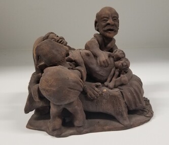 Royal Australian and New Zealand College of Obstetricians & Gynaecologists (RANZCOG)
Sculpture - Ceramic vignette of a caesarean section locked twin childbirth
This is a rare and hazardous obstetric complication, occurring approximately once every 90000 deliveries. It usually results in a low survival rate for the twin that presents first, with a stillborn rate over 50%. This piece is believed to be from South America, and is either from Colombia or Peru.Ceramic childbirth scene with three figures. At centre, a woman lies on a table giving birth. A figure wearing a hat stands to her right, resting their hand on her upper chest in a gesture of support. On her left, a gloved man with receding hairline and a moustache is leaning over her abdomen and is extracting two babies from her womb.obstetric delivery -
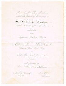 Bendigo Historical Society Inc.
Document - INVITATION FOR WEDDING OF MARLENE SCHILLING AND NEVINSON ANDREW DWYER 20.6.1956
Silver printed cream coloured card INVITATION FOR WEDDING OF MARLENE SCHILLING AND NEVINSON ANDREW DWYER 20.6.1956. Mr & Mrs SCHILLING request the pleasure of the company of Mr & Mrs G Deanau at the marriage of their daughter Marlene with NEVINSON ANDREW DWYER at Melbourne Grammar school chapel Domain Rd South Yarra on Wed 20.6.1956 and afterwards at Ciro's Collins Pl , Melbourne , 5 Newbay Crescent Brighton.ephemera, mementoes, celebrations, marlene schilling and nevinson andrew dwyer /mr & mrs g deanau -
 Robin Boyd Foundation
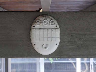
Decorative object - Boyd family crest
Martin Boyd had the Boyd Coat of Arms made to adorn his home at “The Grange”. Penleigh Boyd salvaged it just prior to The Grange’s demolition circa 1958. Its ‘rescue’ and installation at Walsh St is mentioned in Brenda Niall’s “The Boyds” page 339.White-painted timber, oval shape, three roses at the top, three rows of squares, and a crescent at the base.walsh st miscellaneous, robin boyd, boyd family, ohm2022, ohm2022_20 -
 Robin Boyd Foundation
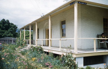
Slide, Robin Boyd
Colour slide in a mount. Corner Hillside Crescent and Hill St, New Norfolk, Derwent Valley, Tasmania6 / Encircled 22 (Handwritten)tasmania, slide -
 Whitehorse Historical Society Inc.
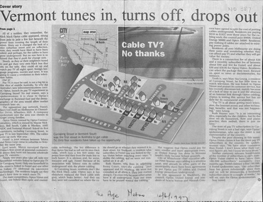
Newspaper - Article, Vermont tunes in, turns off, drops out, 01/06/1997
Residents in Currajong Street, Vermont South initially join up with either Foxtel, Galaxy or Optus but have since been disconnected with the exception of four houses. Some residents in Blackburn are paying to have cables put undergroundtelevision broadcasting, galaxy, foxtel, optus vision, currajong street, vermont south, remy court, acacia avenue, blackburn, waratah crescent, danene court, seamer, peter -
 Whitehorse Historical Society Inc.
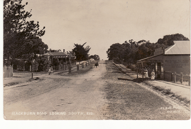
Photograph - Postcard and photograph, Blackburn Road Looking South, 1917 or 1908
Black and white postcard and large photograph of old scene of Blackburn looking south. Figures of 3 children and horse and cart in scene.(on back) Addressed to - Mrs. Hilliard, 'Home' Windsor Crescent, Surrey Hillshilliard, mrs, blackburn road -
 Bayside Gallery - Bayside City Council Art & Heritage Collection
Map, H.B. Foot, Plan of the Brighton Estate containing 5120 acres, first special survey at Port Phillip, c. 1842
This plan records the Brighton Estate, also known as Dendy's Special Survey. In 1840 Henry Dendy, a farmer in Surrey, England acquired a "Special Survey" from the Commissioners for Land and Emigration which gave him the right to choose land in Port Phillip for the low price of £1 per acre for 5120 acres. Dendy appointed Jonathan Binns Were, as his agent, who later became a partner. Together, Dendy and Were decided on an area 5 miles south from Melbourne, bounded by North Road, East Boundary Road, South Road and to the west by Port Phillip Bay. Their Brighton Estate was first surveyed by T. S. Townsend in May 1841 and was re-surveyed by Robert Hoddle. Dendy and Were were making plans to sell the land and advertised a 30-guinea prize for the best subdivision which was to be divided into a village, marine residences, suburban and cultivation allotments, with the remainder being divided into country sections. The competition was won by H.B. Foot, who planned the village around a reserve and crescents and a 'green belt' forming the town boundary. brighton estate, dendy's special survey, special survey, henry dendy, jonathan binns were, w.b. were, survey, plan, map, brighton, george ward cole, baker's lithographer, hibernian, subdivision, town planning, cartographic material, h.b. foot -
 Kew Historical Society Inc
Plan, Studley Heights Estate, 1936
Pru Sanderson, in her groundbreaking ‘City of Kew Urban Conservation Study : Volume 2 - Development History’ (1988), summarised the periods of urban development and subdivisions of land in Kew. The periods that she identified included 1845-1880, 1880-1893, 1893-1921, 1921-1933, 1933-1943, and Post-War Development. These periods were selected as they represented periods of rapid growth or decline in urban development. An obvious starting point for Sanderson’s groupings involved population growth and the associated economic cycles. These cycles also highlighted urban expansion onto land that was predominantly rural, although in other cases it represented the decline and breakup of large estates. A number of the plans in the Kew Historical Society’s collection can also be found in other collections, such as those of the State Library of Victoria and the Boroondara Library Service. A number are however unique to the collection.Subdivision plans are historically important documents used as evidence of the growth of suburbs in Australia. They frequently provide information about when the land was sold on which a built structure was subsequently constructed as well as evidence relating to surveyors and real estate and financial agents. The numerous subdivision plans in the Kew Historical Society's collection represent working documents, ranging from the initial sketches made in planning a subdivision to printed plans on which auctioneers or agents listed the prices for which individual lots were sold. In a number of cases, the reverse of a subdivision plan in the collection includes a photograph of a house that was also for sale by the agent. These photographs provide significant heritage information relating house design and decoration, fencing and household gardens.The ‘Studley Heights Estate’ on the South Side of Studley Park Road was launched in 1936. The seventeen allotments in the subdivision fronted Hyton Crescent and Studley Park Road.subdivision plans - kew, studley heights estate -
 Friends of Westgarthtown
Painting, John Borrack, Last Days Ziebells "The Pines" Thomastown
Painted from the home (or front) paddock which ran south to the creek. The paddock was used for the cultivation of lucerne and maize crops in the lower regions while closer to the house where Ainwick Crescent is now situated, it was a burgeoning market garden for the cultivation of all varieties of vegetables. The large pines beyond, sheltered the farmyard on the west of Gardenia Road. That complex can be partly glimpsed on the left of the painting. This is a directly painted watercolour relying on the use of white paper and transparencies to impart a feeling of morning light. The figure is the artist's mother for whom the picture was painted. Provenance: Augusta Borrack (nee Ziebell) Collection, John Borrack CollectionWatercolour painting, depicting Ziebell's Farmhouse from the south (Thomastown and Mernda). Painting is mounted in a gold frame with cream board.Artist signature: John Borrack; Last Days at Ziebells "The Pines" Thomastown, 'Pro mea matre hanc picturan feci (In Memoria)'illustrations, watercolours, john borrack, ziebell, watercolour, painting -
Surrey Hills Historical Society Collection
Map, Contour map of Surrey Hills showing potential sites for the Telecom Tower
The PMG / Telecom / Telstra tower was built in 1961-1963 as a relay station to support television and radio links between city and regional broadcasting stations. The tower itself was 45 m in height with a 2 storey building for equipment and staff surrounded by garden. From the beginning it was opposed by local residents. The location is said to be the second highest site in Melbourne, sometimes described as Delaney's Hill.Two A3 photocopied sheets of a map showing part of Surrey Hills, roughly between Windsor Crescent and Belmont Street (north / south) and Standard Avenue and Balmoral Crescent (east / west). The map shows contour lines and house sites, 16 of which are numbered. One sheet has been inscribed in top RH corner with notes regarding the significance of the numbers."Contour map of potential sites / for the telecommunications tower which / was eventually sited at 2. / Jock Campbell OBE was our neighbour / at 4 Theodore St when we moved into / the area in 1984. He was responsible in his / job at the PMG in deciding on the /site of the tower - Note site 5 was / behind his (& our) house. / Jack ended his career as Deputy Director / of the PMG. He sat on international committees / after WW2 to decide the split of the electronic / spectrum for radio, TV etc. / His group developed a "mobile phone" using / fixed towers but the phone was a truck full of gear."contour map, telecom tower, maps, jock campbell, john duncan campbell -
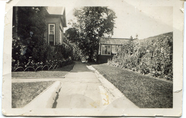 Surrey Hills Historical Society Collection
Digital photo, 45 Wandsworth Road, Surrey Hills, 1956
According to the donor, the photo was taken before the driveway was constructed. The house was later extended at the rear and was re-roofed. The donor's grandparents Daniel Patrick Liddy and Beatrice Bridget Tyner (known as 'Beat') were married in at her parents' home in Glencoe, South Australia on 13 December 1908. They lived in the Carlton / North Melbourne area before moving to Surrey Hills. Electoral rolls list them at 92 Curtain Street, North Carlton in 1913. According to the donor, they rented several properties before purchasing 45 Wandsworth Road. They are listed at Albert Crescent in 1914 and 1919, but also lived in Zetland Road. They purchased 45 Wandsworth Road in c1923 and are listed in the electoral rolls there in 1924. The donor's mother Ellen Dorothy Liddy (known as Eileen) was born in 1909; her brother Daniel John Liddy was born in 1911, both in Carlton. Daniel Patrick Liddy died in 1955; his wife Beatrice died in 1959. They are buried in Box Hill Cemetery (RC183-0045). 45 Wandsworth Road was their home for over 30 years.This image is material evidence of a property that has been demolished.A black and white photo taken from the street looking up a path or narrow driveway. On the LHS is part of a weatherboard house, Edwardian in style. On the RHS is the boundary fence against which is a garden border separated from the driveway by a section of grass. In the background is a glasshouse.Rear along top edge in blue biro: "Aunty Eileens house / before she was married" - according to the donor, this is his cousin's writing. Aunty Eileen was Ellen Dorothy Liddy who married Hugh Turnbull in 1936. Along LH edge, perhaps in a different hand " 23-10-1956" Photo laboratory processing stamp in black ink " 2 48", stamped twice.wandsworth road, daniel patrick liddy, beatrice bridget tyner, beatrice bridget liddy, ellen dorothy liddy, daniel john liddy, box hill cemetery, gardens