Showing 191 items
matching southern right
-
 Kiewa Valley Historical Society
Booklet - Southern Hydro, Southern Hydro
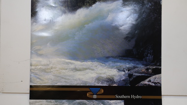
Southern Hydro Ltd. was established in the late 1990s as a result of the disaggregation of the former State Electricity Commission of Victoria. It operates 10 power stations mainly in the north-east of VictoriaSouthern Hydro continued to encourage tourism as did the former State Electricity Commission of Victoria. This brochure is very similar to one previously published by the SECV "Victoria's Hydro Power" except only including those that it operates. Within the KHES the power stations were McKay Creek, Clover and West Kiewa. The change of ownership of hydro power from a government body to private enterprise in the late 1990s is of significant interest to the historian and consumer.Colored photo water spraying onto rocks with black strip across the bottom and logo (4 gold lines forming an "S", a blue triangle with grey cylinder beneath) of Southern Hydro within the strip. Back cover has a similar photo with 4 small photos of men inserted in the black column. This 23 page book gives a history of Southern Hydro and its 10 hydro-electric power stations that it operates. The book lists these and gives a description of each.Top right hand corner of page 5 has a piece of tape stuck over the print with "Page 11 to photo copy & enlarge" secv; khes; mckay creek power station; clover power station; west kiewa power station; mount beauty; rocky valley dam; -
 Eltham District Historical Society Inc
Film - Video (VHS), Jenni Mitchell, Demolition of the Shire of Eltham Offices, 1996
Poor video quality (noise and interference), edited raw footage with music and some commentary by Merv Hanna. A video documenting the demolition of the Shire of Eltham offices at 895 Main Road Eltham under the direction of the Commissioners appointed for the new Shire of Nillumbik and some of the communities activities surrounding the event. The building was demolished exactly 25 years after the southern wing housing Engineering and Planning on the upper level and the Eltham Library on the ground level was opened in celebration of the Shire of Eltham's centenary. Video has lots of distortion and noise, and sections of clips dubbed over. Immediate initial footage of Jenni Mitchell talking about asbestos claims in the Shire Offices (Sigmund Jorgensen standing behind her) advising Council did a review of the building several years previously and had been cleared of health problems. Cuts to group of people standing outside front door of offices but possibly voice dub over not related ? Then the date 27 Jul 1996 on a scene flashes on screen immediately followed by an edited clip intro of title and credits with classical music track. It then opens with Jenni Mitchell driving to the Shire Offices on Saturday 27 July 1996 at 11.00am. Footage of Main Road past Pitt Street, Alistair Knox Park then entering Shire Office driveway which is fenced off and contractor signs hanging up. Scenes at rear of building showing some internal demolition has commenced. View of the Administration wing. More clips of road driving, Alistair Knox Park, Eltham Library and visitor car park for Shire Offices. Cuts to a group of people standing in access to visitor carpark with new Eltham Library in background, one being immediate former Shire of Eltham President, John Graves. Scenes of people looking through chain link fence and security guard checking front door. John Graves being filmed that someone informed him the Shire was offering the building to the Community Health Centre for $2.3 million and that if they had been offered a price of $1.1 for what it apparently was sold for they would have snapped it up. View of truck loaded with brick rubble literally struggling to ascend the hill of Library Place to exit into Main Road. Cuts to a scene looking at Eltham War memorial Hall through the Memorial Gate, then the Shillinglaw trees and large banner sign ‘Delta Demolitions’ hanging on office façade. Views of front door, old library and bluestone wall. Scene (31 Jul 1996) filmed at night of several white crosses with “RIP Community” and “RIP Democracy”. Scene (1 August 1996) again driving along Main Road towards the Shire Offices then scenes of the offices showing substantially more demolition to exterior, groups of people standing on footpath outside watching, Delta heavy demolition machines, woman holding sign “Democracy where have you gone …”, the odd person in full protection gear and breathing apparatus hand carrying materials out to place on rubbish pile in front of people standing on footpath watching (with no protection) and then stamping on it to break it creating dust, security person in hard hat (no other protection) wandering around, many groups standing around watching, news film crew, person standing on roadside edge holding signs facing traffic stating “Pirate Planning” and “ Grant us your ears” also sign on back of parked car “Elthams High Jacks”, another sign “Community Democracy”, views of crosses in Main Road median strip “RIP Community”, groups of people on footpaths and reporters conducting interviews, footage of unknown person standing with Jenni Mitchell and Sigmund Jorgensen advising people have the right to protest, Jenni Mitchell urging people to ask questions of local MP and Council and Sigmund Jorgensen referring to the three historic Shillinglaw trees with demolition machinery operating in background, Jenni Mitchell and others installing more crosses in median strip; demolition machines operating inside and outside the building, more views of onlookers including Sigmund Jorgensen then Police approaching on footpath, workers and machinery continuing to operate, views of the old library being demolished, the former Community Services department, security personnel. Scene (2 August 1996) more heavy demolition machinery in operation smashing building up, people standing around southern wing watching, view overlooking Eltham Library of train pulling in to Eltham station. Scene (7 August 1996) more heavy demolition and people wandering around with only hard hat protection, no dust protection, comments from one operator dumping a bin of material stating “wait till there’s a Hungry Jack’s here, you’ll be laughing, fuel, videos, hamburgers. You’ll be up with the rest of the world soon, you’ll have electricity and everything here, ha ha ha ha”, more heavy machinery demolition and breaking up of materials, view of Hitachi train going by and Administration wing, view inside the front door opening of the staircase leading to upper level, person walking around operating heavy machinery with a hose spraying rubble (no protective gear other than hard hat interspersed with edit cuts of meeting of Commissioners and independent observers on panel as well as members of the community in public gallery. Nillumbik Shire CEO Barry Rochford addressing the meeting., Chief Commissioner Don Cordell directly addressing Jenni Mitchell with respect to permission to take photographs, Barry Rochford continues to address the question asked of Council about the valuation of the former Shire of Eltham Office building/site, public gallery calling out asking why was building demolished, what was the urgency. Scene (14 August 1996) views of southern wing, previous single demolition operator again mocking people filming, operators working in and around building, Shillinglaw trees and largely demolished front, heavy demolition equipment at work, piles of building rubble, hose spraying water over rubble, large trucks arriving for rubble removal and loading of truck. Scene (21 August) more of the same, building virtually down, Shillinglaw trees standing tall and alone, water spraying on rubble and wattle in bloom. Cuts to Council meeting with public onlookers. Barry Rochford walks out, Wayne Phillips addresses meeting explaining one or two people shouting, members of the community challenging Council (Commissioners) about why due process appear to have been subverted. Former Shire President Robert Marshall in public audience, cuts back to Shire office carpark entrance site and sign hung on fence in front of library “Think Again!” and people standing around observing awaiting a protest demonstration erecting a large sign on stilts stating “Shell No!”, people singing a revised version of God Save the Queen (God Save Us All), Sigmund Jorgensen in attendance, Jenni Mitchell, Sigmund Jorgenson and others address the protest crowd, followed by people mingling, music being played then people standing around the cleared site circumference all with arms linked (video very broken up with noise) then chants “Save the Gateway” and “No Shell for Eltham” and more music and singing “Put up a parking lot”. The crowd then proceeds to walk along the footpath of Main Road. Scene (15 Sep 1996) meeting at Montsalvat in Great Hall addressed by Sigmund Jorgensen discussing a recently published list of the Commissioner’s to senior Council Officers of banned Nillumbik people, others encouraging people to view proposed plans for the site and lodge objections. Specific issues regarding asbestos claims are also addressed. Harry Gilham addresses the meeting on the subject of the Eltham War Memorial and Memorial Gardens and how Council believe a roundabout in the vicinity is of greater importance. Views of various artworks on display (for auction) and music performance in the Barn Gallery. Meeting addressed by Sigmund Jorgensen discussing an appeal against Council granting a permit to Dallas Howgate to develop the site and that the Minister has called the matter in to be decided by the governing council. This is followed by an auction of paintings.Hi-Tech Ultra High Grade Video Cassette E-180 VHS dubbing of (poor quality) edited raw footage with some music from Star Wars and commentary by Merv Hannan Converted to MP4 file format 0:30:26, 2.6GBOn label " Merv's Demolition tape No. 2 Copy"video recording, 895 main road, alistair knox park, artworks, auction, barn gallery, barry rochford, community health centre, dallas howgate, delta demolitions, demolition, don cordell, eltham, eltham library, eltham shire office, eltham war memorial, eltham war memorial gate, eltham war memorial hall, great hall, harry gilham, jenni mitchell, john graves, library place, main road, memorial gardens, mervyn hannan, montsalvat, pitt street, protest, robert marshall, roundabout, shell oil, shillinglaw trees, sigmund jorgensen, sign, wayne phillips -
 Eltham District Historical Society Inc
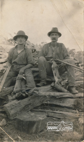
Photograph, Arthur Frederick Castledine (right) sitting on a wood pile towards the rear of their property, Araluen (southern end), Old Eltham Road, Lower Plenty, c.1930, 1930c
Shows the men with rifles sitting on a wood pile out hunting for rabbits around the time of the Great DepressionDigital image of original held in private collection of Joan Castledine, daughter of Sid and Polly (nee Arrowsmith) Castledine, granddaughter of Arthur Frederick Castledine.araluen, arthur frederick castledine, lower plenty, old eltham road, rabbits -
 Federation University Historical Collection
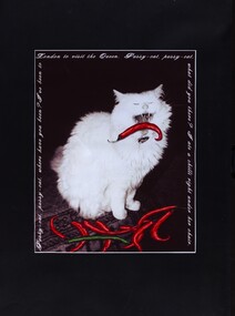
Print, 1 Pussy-cat, pussy-cat where have you been? .2 Abstract Print - Open
Lisa Widdop (16/07/1971-18/01/2024) was an "artist, painter, creator of many things, connoisseur of small and precious things" Quote from her memorial card. Lisa was an alumni of Federation University. Lisa was also a passionate member of OZACT - a touring theatre company dedicated to making Shakespeare accessible to con temporary Australian audiences with performances in Southern Australia's outdoor landscapes. Lisa was involved in management, designing of props, costumes and production of these performances.Coloured prints on black backgrounds.1 Pussy-cat, pussy-cat where have you been? I've been to London to see the Queen. Pussy-cat, pussy-cat what did you there? I ate a chili right under her chair. -
 Lara RSL Sub Branch
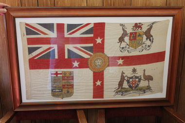
British Commonwealth of Nations flag circ world war 1, British Commonwealth of Nations flag world war 1
British Imperial Forces involved in World War 1Rear representation, Flag White Ensign is made up from Commonwealth Countries and displayed as a flag- Top left-hand corner British flag, right-hand top corner Coat of arms of South Africa, bottom-left Coat of Arms for Canada, Bottom right corner Advance Australia Coat of Arms, flag center is for India is a yellow and red rosette and New Zealand is represented by four white 5 pointed stars centralized as representation of the Southern Cross.The flag on the left border is marked with "Groves"british expeditionary forces flag, union jack, white ensign, coat of arms of south africa, coat of arms canada, coat of arms advance australia, rosette of india -
 Lara RSL Sub Branch
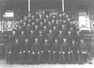
79th Fighter Squadron, Wooloomanata
The 79th Fighter Squadron was initially formed at Laverton on the 26th April, 1943 under the command of flying ace Squadron Leader Alan Rawlinson, but within seven days moved to Wooloomanata Homestead on the Geelong-Bacchus Marsh Rd, No 1580 in Victoria. It was a Spitfire Squadron and used Wooloomanata as a training base before flying. It was disbanded 20th October, 1945.Of national Significance as a Spitfire Squadron training camp in Lara Districts during WW2Glossy photo and A4 documentOn the back of the photo is "No:15 Course 18th April 1943 on the steps of Wooloomanata Homestead Southern Side". On the bottom is a list of the names of those in the photo. Left to Right Rear Row: Maj. K. Ewen, Capt. N.F. Attree, Capt. C.N. Bucknell, Capt. J.L. McKenzie, Capt. C.D. Seabrook, Lt. W.G. Foley. Second row from rear: Maj. C. Dumble, Capt. A. Tavener, Maj. F. Langford, Maj. T.A.R. Cleave, Capt. M.D. Waller, Capt. J.B. Ainslie, Capt. G.M.Taylor. Third row from rear: Capt. E.K. Jennings, Lt. J.H. Loxton, Capt. D.J. Breheny, Lt. R.V. Stephens, Capt J.W.D. Cornell, Maj. C.A. Ricketts, Lt. A.R. Creswick. Fourth row from rear: Lt. W. Ruthven (V.C.), Capt. R.C. Tomkins, Capt. R.J.Bermingham, Maj. A.E. Arnott, Capt. L.S. Ralton, Maj. F.L. Edmunds, Capt. W.E. Paterson. Fifth row from rear: Maj. H.W. Stockwell, Capt. C.A. Ferry, Maj. A.C. Jennings, Capt. W.L. Hart, Maj. R.R. Marston, Capt. R.A. Cameron, Capt. R.W.M. Page. Sixth Row from rear: Lt. A.E. Pizzy, Capt. A.G. Yungman, Maj.T.G. Court, Maj. J.B. Chapman, Maj. H.F. Gough, Maj. P.L. Barbour, Maj. H.M. Heward, Maj. E.C. Nolte. Front Row: Lt. G.H. Rowden, Capt. C.J.F. Pollett, Maj. A.E.Bunbury, Lt-Col. E.W. Bundey, Major W.A. Cronk, Capt. B.V. Eames, Lt. N.D. Anderson, Maj. C.A. Lotherington. Absent: Lt. R.R. Webster, Lt. R.B. Blackwell The A4 is a written description of a brief history of the 79th Fighter Squadron79th fighter squadron, raaf, wooloomanata, spitfire, world war 2, ww2, peter anderson, southern command training school, 15 course 18th april 1943 -
 Bendigo Military Museum
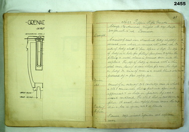
Book - BOMBING SCHOOL NOTES, 27.8.1917
ERNEST HENRY JAMES No 2100 enlisted in the AIF in 3rd reinforcements 38th Batt on 8.5.1916 age 25 years 1 month. Promoted Cpl 1.8.1916, embark for England 25.9.1916, detached to 10th Training Batt England 11.12.1916, hospital 5.2.1917 with PUO, rejoin unit 24.5.1917, attended Bombing School 26.8.1917, rejoin unit 8.9.1917, embark for France 2.10.1917 and rejoin 38th Batt, WIA 24.8.1918 GSW to right leg, embark for Australia 4.1.1919 re his wounds, discharged from the AIF medically unfit 30.3.1919. (PUO) Pyrexia of unknown origin.Exercise book, canvas covered, dark blue, blue ruled. Extensively hand written in ink with hand sketches & printed pages of weapons pasted in. The entire book is on notes taken at Bombing School in England in 1917 by E H JAMES, AIF.“No 2100 Cpl E H JAMES 10th T B LARK HILL” Notes taken at Southern Command Bombing School Lyndhurst 27.8.17.books - military - notes, bombing school -
 Phillip Island and District Historical Society Inc.
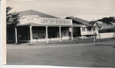
Photograph, 1959
Donated by Jack JennerBlack & White photograph of the Phillip Island co-op on the cnr Chapel Street & Thompson Avenue, Cowes. Two weatherboard houses to the right of building. Three Pine trees.On back: "Site of Southern Trading Store immediately before building. Date should be easy to obtain" (August 1959)phillip island co-op store, chapel street cowes, thompson avenue cowes, phillip island, jack jenner -
 Glenelg Shire Council Cultural Collection
Photograph - Photograph - Southern Farmers & Australian Estates (Portland) Pty Ltd Wool Process, n.d
... evident at top right. Photograph Photograph - Southern Farmers ...Port of Portland Authority archives.Front: (no inscriptions) Back: Portland Harbor Trust Commissioners (purple stamp, top left & bottom right).port of portland archives -
 Glenelg Shire Council Cultural Collection
Postcard - Postcard - Burswood House, Portland, n.d
Black and white photo postcard, of 'Burswood', Portland. View front and right hand side, gardens and lawnFront: 'THE SOUTHERN CROSS SERIES 10799 COPYRIGHT' 'BURSWOOD, "THE OLD HOME OF THE HENTYS, PORTLAND" - printed, bottom margin Back: 7.5 x 134postcard, portland, burswood house -
 Glenelg Shire Council Cultural Collection
Photograph, Southern Farmers & Australian Estates (Portland) Pty Ltd Wool Process, n.d
Port of Portland Authority archives.Front: (no inscriptions) Back: Portland Harbor Trust Commissioners (purple stamp, top left & bottom right)port of portland -
Glenelg Shire Council Cultural Collection
Photograph - Photograph- land reclamation, n.d
Port of Portland Authority Archivesport of portland archives, k s anderson wharf, botanic gardens, reclamation, ocean pier -
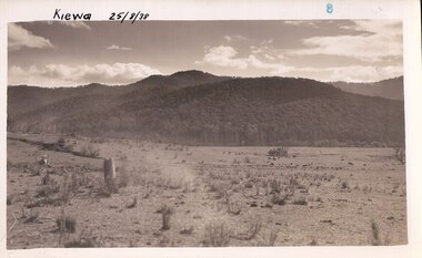
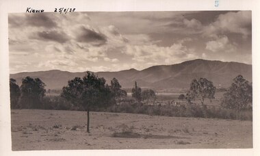 Kiewa Valley Historical Society
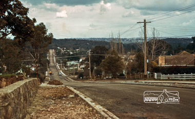
Black and white photograph of farmland, Kiewa, 25/8/38, circa 1938
This photograph was taken in August, 1938 some eight years prior to the establishment of Mt. Beauty as a township. The area was still being used for grazing, and the land was eventually acquired from the local land owners by the State Electricity Commission. The construction of the road, from Tawonga to the High Plains, was commenced in April of this year. This allowed men and heavy equipment to be transported to the work sites for the construction of the Kiewa Hydro Electric Scheme This photograph is important as it shows the upper Kiewa Valley as it was before the establishment of the town of Mt. Beauty. The land has been cleared of natural growth and has been used for grazing cattle. By 1946 housing construction had commenced for the new town of Mt. Beauty and by 1948 street construction in the southern part of the town was completed as far as Hill Street.A black and white photograph of farmland with Mt. Emu in the background. This has been taken from where Mt. Beauty township now stands prior to road making and the erection of houses. A line of trees below the hill line indicates the position of the East Kiewa River. (No. 5 in a set of 8) Handwritten in black ink on the upper left corner of the photograph is the inscription 'Kiewa 25/8/38' and the number 5 has been stamped on the upper right hand corner. On the back is the word 'Velox' which is the name of the photographic paper on which the photo was developed.road construction, kiewa, tawonga, mt. beauty, secv -
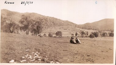 Kiewa Valley Historical Society
Black and white photograph of farmland, Kiewa, 25/8/38, circa 1938
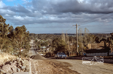
This photograph was taken in August, 1938 at the time of road making in the area and some eight years prior to the establishment of Mt. Beauty township. The area was still being used for grazing, and the land was eventually acquired from the local land owners by the State Electricity Commission. The construction of the road, from Tawonga to the High Plains, was commenced in April of this year. This allowed men and heavy equipment to be transported to the work sites for the construction of the Kiewa Hydro Electric Scheme. An important photograph as it shows the upper Kiewa Valley as it was before the establishment of the town of Mt. Beauty. The land had been cleared of natural growth and has been used for grazing cattle. By 1946 housing construction had commenced for the new town of Mt. Beauty and by 1948 street construction in the southern part of the town was completed as far as Hill Street.A black and white photograph taken in the upper Kiewa Valley showing farmland with a group of three unidentified people sitting on the grass.Handwritten in black ink is the inscription 'Kiewa 25/8/1938'. In the right corner of the photograph has been stamped the number 6. On the back in a circle, some 14mm across, are the words 'Kodak Print'. The word Velox is also printed on the back.kiewa, mt. beauty, construction, grazing, secv -
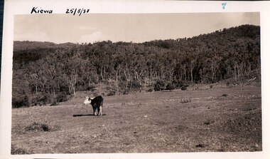 Kiewa Valley Historical Society
Black and white photograph of farmland, Kiewa, 25/8/38, circa 1938
This photograph was taken in August, 1938, some eight years prior to the establishment of Mt. Beauty a a township. The area was still being used for grazing, and the land was eventually acquired from the local land owners by the State Electricity Commission. The construction of the road, from Tawonga to the High Plains, was commenced in April, 1938 and this photograph was taken August, 1938. This allowed men and heavy equipment to be transported to the work sites for the construction of the Kiewa Hydro Electric Scheme. Prior to this access was by bridle trail, either on horse back or on foot. By 1946 housing construction had commenced for the new town of Mt. Beauty and by 1948 street construction in the southern part of the town was completed as far as Hill Street.This photograph is important as it shows the upper Kiewa Valley as it was before the establishment of the town of Mt. Beauty. The land has been cleared of natural vegetation to allow grazing of cattle. Black and white photograph of grazing farmland with one animal standing in the paddock. The area could possibly be where the golf course now stands with the road to the high plains not yet commenced.Handwritten in the upper left hand corner 'Kiewa 25/8/38'. The number 7 has been stamped in the upper right hand corner. It is part of a set of 8 photographs. On the back are the words Velox repeated several times, indicating the type of photographic papergrazing, kiewa, mt. beauty, secv -
 Kiewa Valley Historical Society
Photograph Farm Land, Kiewa, 25/8/38, circa 1938
This photograph was taken in august, 1938 some eight years prior to the establishment of Mt. Beauty as a township. The area was still being used for grazing cattle and the land was eventually acquired from the local land owners by the State Electricity Commission. The construction of the road, from Tawonga to the High Plains, was commenced in April of 1938. This allowed men and heavy equipment to be transported to the work sites for the construction of the Kiewa Hydro Electric Scheme. Prior to this access was by bridle trail, either on horse back or by foot. By 1946 housing construction had commenced for the new town of Mt. Beauty and by 1948 street construction in the southern part of the town was completed as far as Hill Street.This is an important photograph as it shows the upper Kiewa Valley and the site for Mt. Beauty as it was before the establishment of the town. The land has been cleared of natural vegetation and used for grazing cattle.Black and white photograph of farmland, cattle in the distance, hills in the backgroundHandwritten in the upper left hand corner, in black ink, 'Kiewa 25/8/38'. The number 8 has been stamped in the upper right hand side of the photograph. On the back have been stamped the words Velox, indicating the type of photographic paper.kiewa, mt. beauty, construction, grazing, secv -
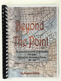 Warrnambool and District Historical Society Inc.
Booklet, Beyond the Point, 2007
... watching area. Southern Right Whales return to this beach each year ...This book was written in 2007 by Margaret McOrist to mark the 150th anniversary of the arrival in the Warrnambool area of John Logan. It is a sequel to a 1991 book, ‘Clotted Cream and Mangels’ which told the story of John Logan and his wife Mary Gardner. They lived at Hopkins Point, Warrnambool and the book, ‘Beyond the Point’ tells the story of the Logan descendants. When the farm land was sub-divided and sold the nearby beach was named ‘Logans Beach’. This book is of considerable interest as it tells the story of the descendants of important early settlers, John Logan and Mary Gardner. The area where they first settled is now of major interest as Logans Beach (named for the Logan family) is the well-known whale watching area. Southern Right Whales return to this beach each year and the females calve and remain up to three months at this beach, making it an important ‘whale nursery’. This is a soft cover book with black plastic ring binding and clear plastic sheets covering the front and back paper covers. The front cover has a reproduction of an 1891 map of Warrnambool and district with the title of the book and other information superimposed on the map. The back cover is black. The book has 101 pages and contains information on the Logan families who lived at Tooram in Allansford and their descendants. There are many black and white and colour photographs, diagrams, maps and family trees. Front Cover: ‘Beyond the Point, 150 years since the arrival of Irish ancestor, John Logan, Hopkins Point, Warrnambool, Victoria, 1857-2007, by Margaret McOrist’. john logan and mary gardner, hopkins point, logans beach, tooram, history of warrnambool -
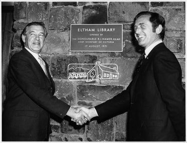 Eltham District Historical Society Inc
Photograph, Opening of Eltham Library, 17 Aug 1971
Official opening of Eltham Library; The Hon. Rupert. J. Hamer, E.D., M.P. (left) and Cr. G.C. Dreverman (right), 17 August 1971, in front of a plaque reading "Eltham Library opened by the Honourable R. J. Hamer E.D., M.P. Chief Secretary of Victoria, 17 August 1971" on the exterior bluestone wall. The Eltham Branch of the Heidelberg Regional Library Service was opened on 17 August 1971 by Victoria’s Chief Secretary R. J. Hamer. The library was designed by the firm Leith and Bartlett and was the southern wing of the Shire of Eltham Offices in Main Road Eltham. Visitors entered a “book plaza” which embodies the display techniques of a bookshop. Through this area was located a quieter area for reference and the more “purposeful” reader. The library was opened as part of the Shire of Eltham’s centenary celebrations. The library and Shire Offices were demolished exactly 25 years later in 1996. The current library was opened in 1994. This photo forms part of a collection of photographs gathered by the Shire of Eltham for their centenary project book, "Pioneers and Painters: 100 years of the Shire of Eltham" by Alan Marshall (1971). The collection of over 500 images is held in partnership between Eltham District Historical Society and Yarra Plenty Regional Library (Eltham Library) and is now formally known as 'The Shire of Eltham Pioneers Photograph Collection.' It is significant in being the first community sourced collection representing the places and people of the Shire's first one hundred years.Digital imagesepp, shire of eltham pioneers photograph collection, shire of eltham, shire of eltham centenary, eltham library, opening day, cr. g.c. dreverman, the hon. r.j. hamer -
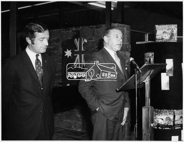 Eltham District Historical Society Inc
Photograph, Opening of Eltham Library, 17 Aug 1971
Opening of Eltham Library by The Hon. R.J. Hamer, E.D., M.P. (right) and Cr. G.C. Dreverman. The Eltham Branch of the Heidelberg Regional Library Service was opened on 17 August 1971 by Victoria’s Chief Secretary R. J. Hamer. The library was designed by the firm Leith and Bartlett and was the southern wing of the Shire of Eltham Offices in Main Road Eltham. Visitors entered a “book plaza” which embodies the display techniques of a bookshop. Through this area was located a quieter area for reference and the more “purposeful” reader. The library was opened as part of the Shire of Eltham’s centenary celebrations. The library and Shire Offices were demolished exactly 25 years later in 1996. The current library was opened in 1994.This photo forms part of a collection of photographs gathered by the Shire of Eltham for their centenary project book, "Pioneers and Painters: 100 years of the Shire of Eltham" by Alan Marshall (1971). The collection of over 500 images is held in partnership between Eltham District Historical Society and Yarra Plenty Regional Library (Eltham Library) and is now formally known as 'The Shire of Eltham Pioneers Photograph Collection.' It is significant in being the first community sourced collection representing the places and people of the Shire's first one hundred years.Digital imagesepp, shire of eltham pioneers photograph collection, shire of eltham, shire of eltham centenary, eltham library, opening day, cr. g.c. dreverman, the hon. r.j. hamer, rupert hamer -
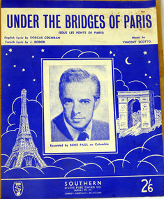 Orbost & District Historical Society
sheet music, Under the Bridges of Paris, first half 20th century
Under the Bridges of Paris" is a 1913 popular song with music written by Vincent Scotto, the original French lyrics (entitled "Sous les ponts de Paris") by Jean Rodor (1913), and English sections of lyrics added by Dorcas Cochran (1952) resulting in the released version (1954) containing both French and English sections. This version of the song was recorded by Rene Paul.The music has social significance as an example of music popular in the first half of the 20th century.Sheet music for "Under the bridges of Paris". The cover is blue with white illustrations of the Eiffel Tower and the Arc de Triomphe. In the centre is a head and shoulders photograph of a man in a suit and tie. It is captioned "Recorded by Rene Paul on Columbia." Under the title are details of the composer and lyricists. In the bottom right corner is the price 2/6.music-sheet under-the-bridges-of-paris -
 Ringwood and District Historical Society
Photographs, 1979-80 MMBW pipe line project at Hubbard Reserve, North Ringwood � Track down to creek bridge
Part of a 43-photo record of the MMBW�s engineering feat in drilling a 12 inch pipe line up to 40 feet deep through rock hardened by volcanic action associated with geological fault that occurs along the line. The work took place from October 1979 to May 1980 on the southern boundary of Hubbard Reserve, North Ringwood. The collection was presented to the Ringwood Historical Research Group by J Clarke on 9th June 1980.E565 N12 13 May 1980 A43 My old track down to the bridge over the creek. The pipe line went to the right of the big tree 40-foot down. -
 Ringwood and District Historical Society
Photographs, 1979-80 MMBW pipe line project at Hubbard Reserve, North Ringwood � Manhole behind 29 Burlock Avenue
Part of a 43-photo record of the MMBW�s engineering feat in drilling a 12 inch pipe line up to 40 feet deep through rock hardened by volcanic action associated with geological fault that occurs along the line. The work took place from October 1979 to May 1980 on the southern boundary of Hubbard Reserve, North Ringwood. The collection was presented to the Ringwood Historical Research Group by J Clarke on 9th June 1980.E566 N5 13 May 1980 A43 Manhole behind 29 Burlock Avenue, 38 feet deep. Debbie place is on the far right. -
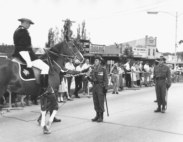 Ringwood and District Historical Society
Photograph, Pump, Brian, Presentation of "Freedom of the City" to 3rd Division Australian Engineers by Mayor, Ben Hubbard, March 27, 1965
Black and White Photograph. See also ABC silent movie of the event in VC record 11129. Ringwood Mail Newspaper article about the ceremony and parade is in VC 11129 Lt. Col. E.R. Baldwin Being challenged. Written on back of one copy of photograph, 'Photo ... Southern Command, Army Public Relations.' Catalogue card reads, 'Freedom of the City. Taken when Ben Hubbard was mayor.' Typed on back of another copy: Police Inspector A. Angus challenging the R.A.E. on their right to enter Rignwood. O.C. replies. this took place outside the entrane to the Railways Station. Date Stamp 27 Mar 1965. -
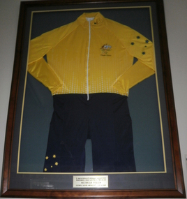 Cheese World Museum
Sports Uniform, Sydney 2000 Olympic Games Cycling Uniform, 2000 (estimated)
Uniform worn by Michelle Ferris, a Warrnambool athlete, who was sponsored by Warrnambool Cheese and Butter Factory. Long sleeved yellow lycra top joined to navy shorts, with a zippered front opening. Australian emblem and Sydney Olympics logo. the left sleeve and right leg have stars of the Southern Cross. The uniform is displayed in a wooden frame.On the frame- in appreciation of continued support of the Warrnambool Cheese and Butter Factory Co Ltd. Michelle Ferris Olympic Silver Medalist 1996 & 2000cycling, warrnambool cheese butter factory, ferris michelle, sydney, olympic games, uniforms -
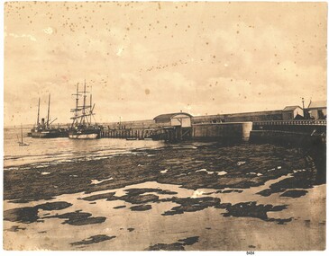 Flagstaff Hill Maritime Museum and Village
Photograph - Coastal Scene, Joseph Jordan Photographic Studio, Lady Bay and Breakwater, Warrnambool, circa 1907
The Port of Warrnambool - In the early years the Port of Warrnambool was a busy port. Steamships and sailing ships were frequent visitors to the port. Steam navigation companies were plentiful, carrying passengers and freighting cargo such as coal, timber, food, livestock, furniture, hardware and haberdashery between Melbourne and the ports along the southwest coast of Victoria, including Warrnambool. The carts would take their loads into the township for distribution. The Breakwater was built (using 32 ton blocks of concrete) between 1874 and 1890 to provide ships with greater protection from the Southern Ocean. The Lifeboat and Rocket House - The coastline of South West Victoria has had over 600 shipwrecks and many lost lives; even in Warrnambool’s Lady Bay there were around 16 known shipwrecks between 1850 and 1905, with eight lives lost. In 1859 the first Government-built lifeboat arrived at Warrnambool Harbour and a shed was soon built to house it, followed in 1864 by a rocket house to safely store the Rocket Rescue equipment. In 1878 the buildings were moved to the Breakwater area, and in 1910 the new Lifeboat Warrnambool arrived with its ‘self-righting’ design. For almost one hundred years the lifeboat and rocket crews, mostly local volunteers, trained regularly to maintain and improve their skills, summoned when needed by alarms, gunshots, ringing bells and foghorns. Some became local heroes but all served an important role. By the end of the 1950s the lifeboat and rescue equipment had become obsolete. Joseph Jordan - Joseph Jordan was born in 1841 in Leicester England. When he was 16 he joined the 7th Queen's Own Hussars and was sent to India at the outbreak of the mutiny. He took part in the relief of Lucknow and remained in India for eleven years. It was during this time, he became interested in photography. He was posted to New Zealand and later came to Victoria, becoming a sergeant major of the Mounted Rifles. In the mid 1880s he came to the Western district where he was responsible for establishing units of the Mounted Rifles in various country towns such as Dunkeld, Mortlake, Panmure, Bushfield, Koroit etc. He resigned from the army in 1889 and set up a professional photography studio in Liebig Street, Warrnambool. He became very well known in the Western District for family photographs, official photographs of local councillors and groups as well as views of local scenery. In 1891 he photographed the wrecked barque "Fiji" at "Wrecks Beach" near Princetown. His business was taken over by his son Arthur around 1917. Joseph was a keen rifle shot and in 1924 he donated the "Jordan Shield" as a prize to the Victorian Rifle Association. He was made a "Life Honorary Member" of the Warrnambool Returned Soldiers League and in 1933 he was recognised as being the oldest living soldier in Victoria. Joseph died in 1935 aged 95.This photograph is significant for its association with the Port of Warrnambool and the Warrnambool Breakwater as it shows a point in time when shipping activities were an important part of Warrnambool's commerce and social development. It is also a record of the Warrnambool Lifeboat and Rocket house which was important in aiding ordinary citizens, harbour employees and the volunteer boat and rescue crew in saving the lives of sailors and passengers due to the high number of shipwrecks that occurred along the coastline. Joseph Jordan is a significant figure in Warrnambool history as he helped to establish early units of the Mounted Rifles (G Company) in local towns during the late 1880's and later, photographed local scenes, groups and citizens of early Warrnambool. Sepia photograph showing the beach and the Breakwater in Lady Bay Warrnambool, two ships (a steamship and a barque), a small sailboat, and the Lifeboat and Rocket House plus two smaller sheds.Front of photo - BREAKWATER, WARRNAMBOOL, VICTORIA Back of photo - "From: P Gregory / 365 Beach Road / BLACK ROCK 3193"flagstaff hill, flagstaff hill maritime museum, warrnambool, warrnambool harbour, port of warrnambool, tramway jetty, breakwater, lifeboat and rocket shed, steamship, barque, photograph of lady bay, rocket house, shipping, joseph jordan, lady bay, views of warrnambool, jordan photography -
 Eltham District Historical Society Inc
Photograph, Fred Mitchell, Road construction and sealing of southern end of Bible Street, Eltham, 1968, 1968
House on right is on corner of Bible and York (67 Bible Street).Digital copy of colour photographfred mitchell collection, 1968, bible street, eltham, houses, road construction -
 Eltham District Historical Society Inc
Photograph, Fred Mitchell, Road construction and sealing of southern end of Bible Street, Eltham, 1968, 1968
York Street just behind the Pontiac. House on right is on corner of Bible and York (67 Bible Street).Digital copy of colour photographfred mitchell collection, 1968, bible street, eltham, houses, road construction -
Glen Eira Historical Society
Document - BRIGHTON GENERAL CEMETERY
This file contains two brochures from the Brighton General Cemetery, one black and white dated 2013, the other in colour and undated. The first provides eight short biographies of notable writers and journalists interned at the cemetery, the other containing a map with the location of thirty-four notable internments unrelated to literature. Both provide a brief history of the cemetery with the first also including images of some of the people discussed and what appears to be the cemetery emblem. The second brochure displays a colour photograph of a structure in the cemetery.cemeteries, brighton, authors, journalists, occupations, people, documents, pamphlets, tourist leaflets, migrants, widowers, knowles marion, cambridge ada, buckley herbert, browne thomas alexander, walstab george alexander, cunningham edward sheldon, dow john lament, dexter caroline, lynch caroline, brighton general cemetery, people associated with culture, brighton cemetorians, east brighton north road, people by circumstance, knowles joseph, cross george frederick, ribbledon herbert, horseracing, equestrian events, pioneers, squatters, civil servants, police, boldrewood rolf, robbery under arms, the miner’s right, babes in the bush, communication activities, the age, the herald, the argus, edward wilson estate, burketown, the leader, walstab mary anne, nolan anne, jackson maval mary, sir graham barry ministry, dow marion jane, orr marion jane, mckenzie david, dexter william, ladies almanack: the southern cross or australian album and new years gift, institute of hygiene, lynch william, mayors, bombala, cheltenham pioneer cemetery, cheltenham memorial park, bunurong memorial park, cheltenham and regional cemeteries trust, springvale cemetery, southern metropolitan cemeteries trust, manson johanna, religious groups, groups (people), funerals, cremation, joynt william donovan, boyd arthur, peeler walter, soldiers, armed forces, mccubbin frederick, casey james joseph, buckley maurice vincent, ogg charles, catani carlo, sutton henry, newland james ernest, laver frank joseph, furphy john, boyd guy, ballantyre george frederick, gordon adam lindsay, mccoy frderick, higin batham george, monash john, bent thomas, miller septimus, cohen godfrey abraham, creswell william rooke, guilfoyle william, boyd theodore penleigh, heinze bernard, taylor joseph leslie theodore, taylor squizzy, tritschke alma, elder james alexander mackenzie, breen marie, boyd william merrie, boyd doris, maps, east brighton hawthorn road, east brighton sheffield road, east brighton sussex road, presbyterian religion, baptist religion, jewish religion, roman catholic religion, methodist religion, church of england, anglican religion -
 Federation University Historical Collection
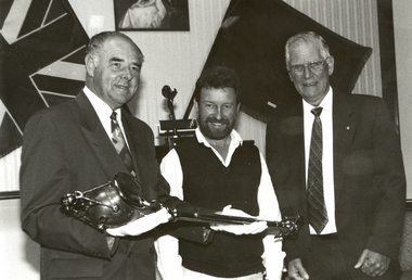
Photograph - Black and White, The University of Ballarat Mace, 1996, 1996
The University's mace was carried in procession for the first time during the Graduation ceremonies in May 1996. The mace was presented to the University by former Chief Commissioner of the Ballarat City Council, Vern Robson, at a ceremony on 02 February, following a national competition for its design, sponsored by the Council. (The Flag, Issue 2, July 1996) Nineteen artists responded to the competition which called for a design that would embody a distinctive Australian image reflecting the heritage of the city and in relationship with gold, an Aboriginal element and the history of the University. The winning entry, dominated by a poppet head, was submitted by Central Victorian artist/sculptor Trefor Prest, a sessional lecturer in sculpture at the University.(The Flag, Issue 2, July 1996) The Herald Sun of 03 February 1996 reported 'the new mace shows importance elements of Ballarat's heritage as well as the university's focus on the future. The artist emphasises the egalitarian nature of Australia as embodied in Ballarat's famous slice of history - the Eureka uprising. ... The mace has a poppet head at the top of the shaft - an unusual element for a mace - but it represents Ballarat's mining history and the University's evolution from the Ballarat School of Mines. An opening egg at the top stands for the nurturing of development and learning. The mace's straight shaft is depicted as the tree of knowledge and, incorporating a bark canoe scar, Ballarat's Aboriginal heritage. At the end of the shaft is a surveying device, which represents precision and accuracy ads embodied in the university's academic pursuits.' Bob Morrell of the University organised the national competition to design the mace and said 'It is in keeping with the university's logo, 'proudly flying the flag', which incorporates the Southern Cross.' Trefor Prest lectured in Sculpture at the University of Ballarat from 1995-1996.Black and white photograph showing three men holding the new University of Ballarat (now Federation University) mace. From left to right they are Vern Robson (Chief Executive Officer City of Ballarat), Trefor Prest (Sculptor) and Professor David James (Vice Chancellor).university of ballarat, mace, trefor prest, vern robson -
 Flagstaff Hill Maritime Museum and Village
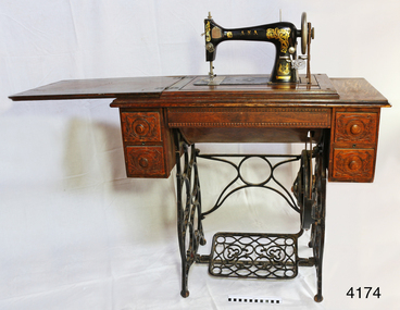
Domestic object - Sewing Machine, Early 20th century
Ward Brothers (George and Samuel) registered a company (Australian Sewing Machines Limited Pty Ltd) with the head office address in Errol St, North Melbourne, and Prahan. The earliest newspaper advertisement for this company was in 1897. Around this time the Ward Brothers first imported sewing machines from England and Wertheim placed their decal on them and mounted them in their own Australian made cabinets. David Ward later imported machines from Beisolt & Locke in Germany and registered name A.N.A. (All Native Australian), his shop was in Collingwood Melbourne. Some of these machines had Ward Brothers decals on them as well. The three brothers sold under the same name as Ward Brothers. The early Ward Brothers logo had a map of Australia with a picture of all three brothers on it. In 1911 all three of the Ward Brothers decided to share a stall in the yearly Melbourne exhibition. The A.N.A was the machine that got rave reviews. It was at this time that the Australian Sewing Machine Company Pty Ltd decided to add the A.N.A logo to their logo to cash in on the new found celebrity status that the A.N.A has gained. To cut a long story short. David Ward took his brothers to court to prevent this from happening. This was a long drawn out affair that took quite a few years. The settlement was decided out of court and nothing was disclosed of the deal that was made. David seemed to have left the scene, then the remaining Ward Brothers and A.N.A. combined and then became “Wardana”. There are many Ward Brothers sewing machines in displays, they originated from Japan, England, America, and Germany. It seems that where ever they got the best deal for sewing machines or parts is the direction they went. This is where the Bendigo sewing machine company came into the picture. All imported sewing machines into Australia drew a government tax. Bendigo Cording's Traction Company was given proposed two-pound tariff protection that gave the company a significant price advantage for its machines. As a result, the Ward Brothers purchased a huge number of Bendigo shares to get cheaper machines for their sewing machine cabinets. Ward Brothers then placed one of their company officials on the Board of “Bendigo Sewing Machines Limited” and the rest is history. Ward Brothers had shops Australian wide and in most of the major country towns. History for “Bendigo Sewing Machines Limited” Cordings Traction Company owners (H. Keck MLC, W. Wallace, and W. Ewing) operated their business out of the former W. Webb & Co. building in Queen St. Bendigo. Around 1923-1924 they decided to switch from traction engines to manufacturing sewing machines. The actual date is not known but that year's financial report made note of both Cordings and Bendigo Sewing Machines Limited. The switch was made with the government of the day agreeing to a tariff of two pounds per head for every machine head made completely in Australia. The change from traction engines to sewing machines went well. Government representatives visited the factory in Bendigo to inspect and ensure that the sewing machines were Australian made as a result they agreed on granting the two-pound tariff to the company. After the first 12 months, they built 30, the following 12 months the company had produced 1500 machines probably due to the involvement of the Ward brothers. However, the government proposed a new condition to the tariff agreement which was that the company must produce 20% of Australia's requirements for sewing machines. In 1924 after having had produced 1500 machines resulting in reaching their financial limit for tariff support. According to the government, the requirement was 15,000 machines for the next year had to be produced to qualify for the tariff. The company had already reached its production limit and unfortunately folded. There were several attempts to regain government assistance to save this new industry but it was to no avail. Even a promise to open another factory in Sydney was offered but unfortunately wasn't accepted. An item fabricated in Australia from a majority of imported parts from either Germany, America or England giving a snapshot into the early manufacturing industries that were operating at the time of Federation. Sewing machine, treadle, in timber cabinet. Branded Ward Bros, A.N.A., Australian Sewing Machine Coy. Decorative carved timber cabinet, hinged, fold-out laminated timber top and five drawers; two small on each side with handles and one long, shallow, between side drawers without handle. Thread is on bobbin in a rocket shuttle (both in good condition) plus spare empty shuttle (rusty). Brass ‘Half Yard’ ruler inlaid across front, measuring scale in inches and centimetres. Two metal shuttle cover plates (or throat plate / slide plate); front one is impressed with a gauge for needle and thread. Gold trim and decals on flatbed and machine front and back, serial number under shuttle cover, brand on decals and on round metal plate on back of machine. Front right of machine has a bobbin winder. Treadle belt shows signs of wear and laminate on timber machine cover is peeling slightly.Decal coat of arms on right front of machine: kangaroo on left, man with broad-brim hat, holding pick-axe on right, in centre, top “SEWING MACHINE / THE / A. N. A.” then below it, the rising sun, then below that is state of Victoria shield with the Southern Cross constellation. Wheat sheaves around edge on left and flowering plant on right. Gold ribbon banner at bottom with script “WARD BROS.“ Decal of map of Australia on flatbed of machine. States and capital cities are marked and named (no northern territory), portrait of two men. In centre of map are interwoven letters “A. N. A.” and written in script “WARD BROS.” Decal across front of machine body has large, decorated gold lettering “A. N. A.” Decal across the top of machine “THE AUSTRALIAN SEWING MACHINE COY. PTY. Ltd.” Steel shuttle cover at front has an impressed gage listing cotton and needle sizes and number of stitches. Brass disc on back of machine “A. N. A.” in centre. Brass ruler across front of machine has carved or pressed words in the timber. In centre “INCHES” above ruler and “CENTIMETRES” below ruler, and on right above ruler is “HALF YARD” Decal across back of machine’s body “A.N. A. / MADE IN U.S.A.” Stamped into metal under shuttle cover is “219415” (2 and 5 are partially there, first 1 could instead be a 7) flagstaff hill, warrnambool, shipwrecked coast, flagstaff hill maritime museum, maritime museum, shipwreck coast, flagstaff hill maritime village, great ocean road, ward bros., australian sewing machine co., a.n.a., treadle sewing machine, rocket shuttle sewing machine, home industry, clothing, wardana, australian sewing machine company, all native australian, dressmaking, clothing manufacturer