Showing 289 items
matching steep
-
 Otway Districts Historical Society
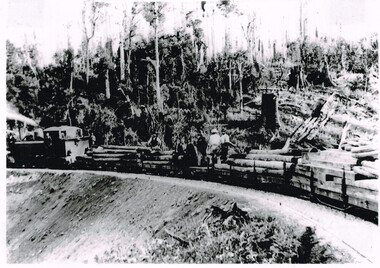
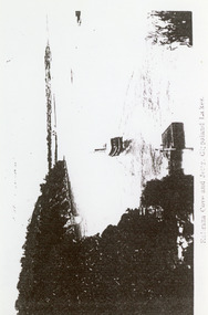
Photograph, Knox Collection, Train hauling timber to build Colac-Beech Forest railway, 1901, 1901
The first engines to run on the Colac-Beech Forest line between 1900 and 1902 as work trains were A Class locomotives, otherwise known as 'Coffee Pots'. They were based and serviced at Colac, but coal stages were erected at Barongarook and Wimba water tanks because of the lengthy periods of waiting time required to unload sleepers and rails or to load ballast.An A Class train on a revetment hauling timber and men to build the Colac-Beech Forest railway, with a steep hillside in the background.. B/W.colac; beech forest; railway; timber; -
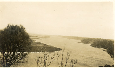
 Lakes Entrance Historical Society
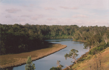
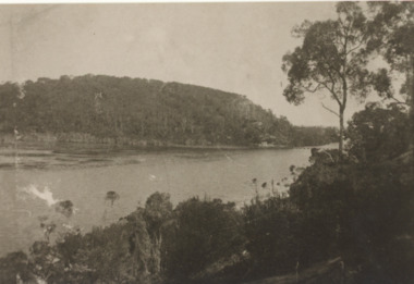
Photograph - North Arm Lakes Entrance, M Holding, 1/03/2009 12:00:00 AM
Colour photograph showing large bay of North Arm and calm waterway between steep timbered banks Lakes Entrance Victoria tourism, houses, waterways, lakes entrance -
 Coal Creek Community Park & Museum
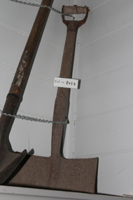
Shovel
8454.1 - Shovel blade is deep with fairly steep sides and with a short shaft with a "D" handle that has two pieces of wire wound around it. -
 Surrey Hills Historical Society Collection
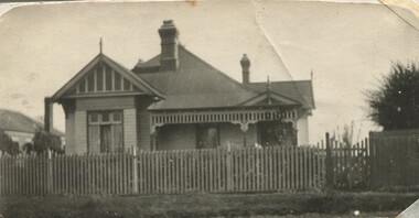
Photograph, 10 Pembroke Street, Surrey Hills
William Valentine Hill (1854-1940) journalist, was the owner of 'Eignbrook',10 Pembroke Street from 1904. His wife was Annie Boak (1865-1943); they were married in 1885. William Hill (Bill) Dempsey was his grandson. His mother Laura Constance Hill married Herbert T Dempsey in 1925.Original sepia photograph of the street view of a weatherboard in the Queen Anne style with a steep pitched iron roof; house is fronted by a picket fence. There are 2 copies of this original photo; the better copy has been scanned. The second copy is slightly mottled and the edges left and right have been cropped so that the adjacent house is not seen. Back of photo 1 is inscribed “10 Pembroke St. Donor W Dempsey”. Photo 2 has inscribed on back "Hills home, 10 Pembroke St, Surrey Hills. Donor W Dempsey" Card has written underneath the photo, “10 Pembroke St”pembroke street, hills family, 'eignbrook', house names, surrey hills, (mr) william valentine hill, journalist, (mrs) annie hill, (miss) annie boak, queen anne style -
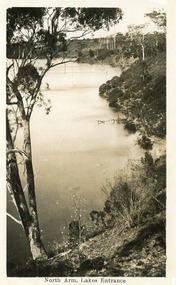 Lakes Entrance Historical Society
Postcard - North Arm, 1930c
Black and white postcard of the calm waters of North Arm. It shows the lake below steep tree covered banks. Lakes Entrance VictoriaNorth Arm Lakes Entrancewaterways, vegetation -
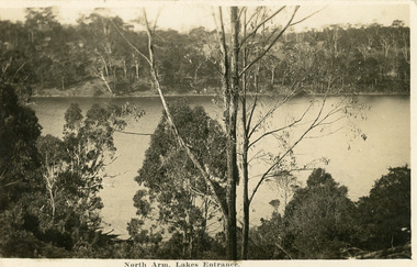 Lakes Entrance Historical Society
Postcard - North Arm, 1930c
Black and white postcard of a calm reach of the North Arm, showing the natural vegetation on the steep banks bordering the lake. Lakes Entrance VictoriaNorth Arm Lakes Entrance waterways, vegetation -
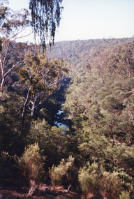 Lakes Entrance Historical Society
Photograph - Boggy Creek Gorge, 1999
Boggy Creek Gorge cuts through volcanics just before it meets salty water at Nowa Nowa Arm of Lake Tyers.Colour photograph from a vantage point of the distant Boggy Creek Gorge surrounded by steep tree and scrub covered ranges. Nowa Nowa Victoriavegetation, waterways -
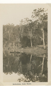 Lakes Entrance Historical Society
Postcard - Lake Tyers
Black and white postcard of waterway showing rowing boat on lake, steep bank in background timber reflections in calm water Lake Tyers VictoriaReflections Lake Tyerswaterways, forest, boating -
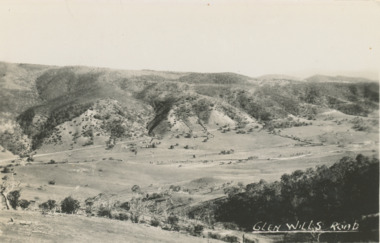 Lakes Entrance Historical Society
Postcard - Glen Wills Victoria, 1940 c
For over 20 years from 1893 gold mining was undertaken in the mountains around Glen Wills.Black and white postcard looking towards the Glen Wills Road situated between the valley and steep hills taken in summer Glen Wills Victoriasettlement, topography -
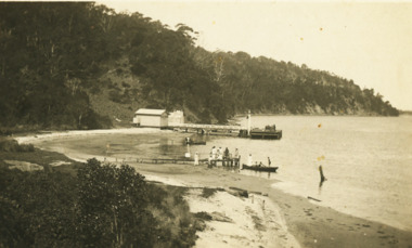 Lakes Entrance Historical Society
Postcard - Kalimna Jetty, 1925 c
Also two black and white postcards showing distance view of Kalimna Jetty 05282.1 and .2Black and white postcard showing people on a small jetty at Kalimna Cove, Kalimna Jetty and sheds in distance with steep cliffs in background Kalimna VictoriaKalimna Lakes Entrance waterways, jetties -
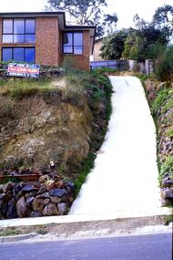
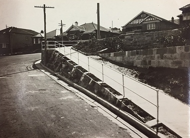 Kew Historical Society Inc
Photograph, City of Kew, Public Works, Road Making, c.1920s
An original photograph donated to the Kew Historical Society by the City's Engineering Department before the amalgamation of Kew into the City of Boroondara in 1994. While not all of the photographs are of Studley Park, Kew or East Kew, each photo provides a fine snapshot of the work of local government engineering departments of the period. They reveal they types of labour conducted, the techniques used and the equipment and machinery in the possession of the local government authority.Public works. A high retaining wall holds back an embankment on a steep slope around which a road turns. It is believed that the photograph dates from the 1920s. Inscription on reverse: "A difficult corner designed to obviate the use of steps. / Pedestrians using the road in front of the dwellings step off the pathway at the telegraph pole".city of kew (engineering department), engineering, road construction building -
 Victorian Interpretive Projects Inc.
Photograph - Colour, Clare Gervasoni, Drystone wall at White Flat, Ballarat, 07/10/2012
White Flat was an early gold diggings. As early as 1856 the White Flat Drainage and Mining Co. constructed water races, drained the swampy land, and changed the course of the Yarrowee Creek. This may be remnants of that work. See http://bih.ballarat.edu.au/index.php/White_Flat_Drainage_and_Mining_Co.#cite_note-0 Five colour digital imaged of a bluestone drystone wall at White Flat, Ballarat. The drystone wall is on the steep embankment between Hickman Street and Armstrong Street South. ballarat, white flat, white flat sports ground, hickman street, south street, armstong street, oval, cricket, football, white flat drainage, yarrowee creek drystone, bluestone -
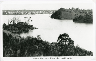 Lakes Entrance Historical Society
Photograph - Lakes Entrance, 1940c
Black and white photograph of the township from the North Arm. It shows the calm waters between steep shorelines covered in natural vegetation and scrub. Lakes Entrance VictoriaLakes Entrance from the North Armvegetation, topography, waterways, township -
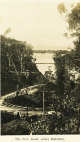 Lakes Entrance Historical Society
Postcard - The New Road Lakes Entrance, 1922 c
Also three postcards showing different views of the road around Jemmys Point 05281.1, .2 and .3Black and white postcard showing view of new alignment of the Princes Highway on Jemmys Point and part of the original high steep road approaching Lakes Entrance VictoriaThe New Road Lakes Entrance waterways, roads and streets -
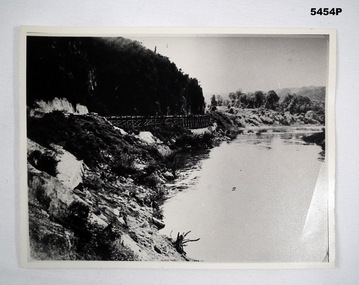 Bendigo Military Museum
Photograph - PHOTOGRAPH, WAMPO BRIDGE, C1943-1948
REFER TO CAT 5445.2Photograph black and white. River, jungle covered hills. In the centre of the photo is a rail trestle bridge set against the steep hillside. The trestle bridge is made from timber On the rear of the photograph in ink. - 122326 WAMPO BRIDGE THAILAND- BURMARAILWAYww2, pow, burma railway -
 Port Fairy Historical Society Museum and Archives
Photograph, 1906
This photograph of the Merrijig Inn was taken from the top of the flour Mill.Black and white photograph of Black and white photograph of a steep roofed rendered cottage on the left hand corner of the street with the bluestone customs house on the right and the courthouse on the far righthotel, gipps street, merrijig inn, campbell street, inn, cottage -
 Lakes Entrance Historical Society
Photograph - Reeves Channel, 1930c
Black and white photograph of Reeves Channel on Lake King, Gippsland Lakes. It shows part of Rigby Island opposite the steep mainland shore of the lake. Lakes Entrance Victoriaislands, waterways, topography -
 Greensborough Historical Society
Slide - Photograph, John Ramsdale, Apollo Parkways: Slide 131, 1990s
Photograph shows a house with steep drive and sold sign in the Apollo Parkways estate Greensborough.Part of the John Ramsdale collection of slides and audio visual material.Colour photograph scanned from slide.No maker's marks. No caption on slide.apollo parkways -
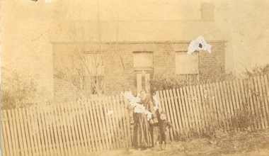 Federation University Historical Collection
Photograph, Woman and child in front of a house
Sepia photograph of a pregnant woman holding the hand of a child standing outside a picket fence on a very steep slope. The fence encloses a brick house. The house is quite possibly in Ballarat.woman, unidentified woman, house, steep street -
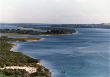 Lakes Entrance Historical Society
Photograph - Lake King, Tambo Shire, 1995c
Also second copyColour photograph of portion of Rigby Island, Fraser Island, and Flannagan Island, and Reeves Channel of Lake King, Gippsland Lakes. Steep shore of mainland in distance. Lakes Entrance Victoriaislands, waterways, topography -
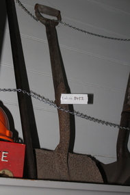 Coal Creek Community Park & Museum
Shovel
8452.1 - Not of "coal shovel" type ( blade lacks steep sides); has "D" handle; blade is secured to handle shaft by bolt and washer, but also a loop of thick wire through shaft. -
 Lakes Entrance Historical Society
Photograph - S.S. Gippsland, 1920c
Black and white photograph of the steamer Gippsland leaving the Kalimna Jetty Gippsland Lakes Victoria. It shows the steep cliffs of Jemmys Point Bullock Island and entrance in the background. Lakes Entrance VictoriaKalimna Cove and Jetty Gippsland Lakesjetties, topography, ships and shipping -
 Lakes Entrance Historical Society
Photograph - Lake Bunga, H D Bulmer, 1910c
Sepia toned photograph showing heavily timbered steep banks on each side of calm water, distant view of timber tramway bridge which appears to be intact Lake Bunga Victoriaocean, vegetation, coast -
 Lakes Entrance Historical Society
Photograph - Lakes Tyers Landing, Wendy Price, 2008
This photograph was paired with image 03733 for display Lakes Entrance 150 years 1858 to 2008 held October 2008. Lake Tyers Beach originally known as Cross's Landing.Colour photograph of Lake Tyers taken from the car park below the Water Wheel Tavern looking N.E. showing waters of lake against steep shore Lake Tyers Victoriaocean, topography -
 Greensborough Historical Society
Slide - Photograph, John Ramsdale, Middle Gorge Park on Gorge Road: Slide 41, 1990s
Photograph shows a bridge with van, road is on steep hill. This is the carpark at Middle Gorge Park on Kurrak Road Yarrambat.Part of the John Ramsdale collection of slides and audio visual material.Colour photograph scanned from slide.No caption. Printed maker's mark on slide "Kodak Kodachrome Slide"middle gorge park, kurrak road yarrambat, plenty gorge metropolitan park -
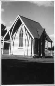 Stawell Historical Society Inc
Photograph, Lodge Building near the Cemetery Entrance
Lodge building at Stawell Cemetery entrance. This small building inside the cemetery gates in earlier years was used by clergy to change into their robes also by horse drawn vehicles. Black & White photograph of a church like weather board building with a steep iron roof. The building has a lancet window and narrow veranda and is located at the entrance to the Stawell cemetery. Photograph taken in 1984.stawell cemetery -
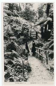 Mt Dandenong & District Historical Society Inc.
Photograph, Sassafras Gully, Victoria, c1920
The tourist track running alongside the creek from Sassafras Mechanics’ Hall to Emerald. In the early 1900s the track started at Rostrevor Guest House.Black and white copy of Rose Series Post card P. 74 showing two young women standing on a footbridge at Sassafras Gully. A set of steep steps can be seen above them.rose series, track, footbridge, bridge, sassafras -
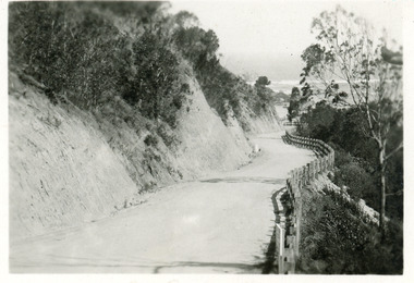 Lakes Entrance Historical Society
Postcard - Princes Highway Kalimna, 1920c
Black & white small format postcard of the Princes Highway at Kalimna. It shows the gravel road between the steep road cutting and post & rail fence. Bass Strait in distance. Lakes Entrance Victoriaroads and streets, fences, waterways -
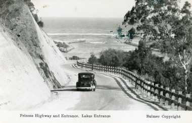 Lakes Entrance Historical Society
Postcard - The Entrance, Bulmer H D, 1930c
Black and copy 9 x 13.5, has inscription 'Princes Highway and Entrance, Lakes Entrance', ink spill on photo top right hand areaTinted small format postcard of the Princes Highway winding around Jemmys Point, between the steep road cutting and post and rail fence, entrance to Gippsland Lakes in the distance. Lakes Entrance Victoria waterways, roads and streets, vehicles -
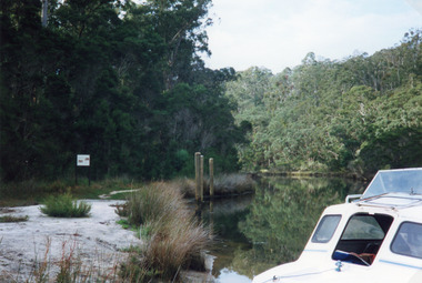 Lakes Entrance Historical Society
Photograph - North Arm, 1997
Date made 18 January 1997.Colour photograph of a landing in upper reaches of North Arm, showing tree covered steep banks, cabin of small boat moored in foreground. Reflection in calm waters of the lake. Lakes Entrance Victoriahistoric sites