Showing 108 items
matching steep street
-
 Marysville & District Historical Society
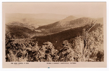
Postcard (item) - Black and white postcard, Rose Stereograph Company, Nichol's Lookout, Marysville, Victoria, 1913-1967
A postcard in a series produced by the Rose Stereograph Company in Victoria, Australia as a souvenir of Marysville.A black and white photograph of the view of the surrounding hills from Nichol's Lookout which is on the Marysville-Wood's Point road near Marysville in Victoria. The Marysville-Woods Point Road was originally part of the Yarra Track, constructed in the early 1860s to provide access between Healesville and the Woods Point Goldfields. Despite the steep terrain and engineering difficulties, the Yarra Track soon became a busy route used by pack horses, horse-drawn drays, and wagons. Today this sealed mountain road is a popular scenic drive between Marysville and Warburton.POST CARD The "Rose" Series/ De Luxe A Real Photograph/ Produced in Australia Published by the Rose Stereograph Co.,/ Armadale, Victoria. "The Falls"/ Marysville/ Monday Dear Mrs Wilson. Just a line to let you know/ I'm here by Dr's advice. He advised me/ to get extended leave. I'm suffering from/ blood pressure so have to go slow-no/ walking-Ugh-a bitter pill to swallow/ in these glorious surroundings. However/ I'm feeling much better and hope on my/ return (Saturday) to be able to resume duty/ I trust you and yours are well, Your loving/ friend A Butler. Quite/ an imposing/ hotel now/ stands at/ Keppel's/ Corner./ A.B.nicol's lookout, lookout, marysville, victoria, p. 2324, rose series postcard, postcard, souvenir, yarra track, mining, wood's point -
 Marysville & District Historical Society
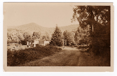
Postcard (item) - Black and white postcard, Rose Stereograph Company, The Wood's Point Road, Marysville, Vic, 1913-1967
A postcard in a series produced by the Rose Stereograph Company in Victoria, Australia as a souvenir of Marysville.A black and white photograph of the Wood's Point Road in Marysville , Victoria. This is now known as the Marysville-Wood's Point Road. The Marysville-Woods Point Road was originally part of the Yarra Track, constructed in the early 1860s to provide access between Healesville and the Woods Point Goldfields. Despite the steep terrain and engineering difficulties, the Yarra Track soon became a busy route used by pack horses, horse-drawn drays, and wagons. Today this sealed mountain road is a popular scenic drive between Marysville and Warburton.POST CARD REAL PHOTO THE "ROSE" SERIES DE LUXE PRODUCED IN AUSTRALIA Published by "The Rose Stereographer"/ Sydney and Melbourne.wood's point road, marysville-wood's point road, marysville, victoria, p. 10201, rose series postcard, postcard, souvenir, yarra track, mining, wood's point, warburton -
 Marysville & District Historical Society
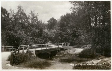
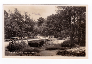
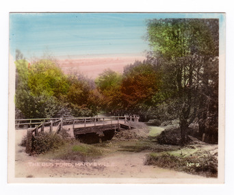
Postcard (item) - Black and white postcard, Valentine Publishing Co. Pty. Ltd, The Old Ford, Marysville No.9, 1923-1963
An early black and white photograph of the old ford in Marysville, Victoria.An early photograph of the bridge at the end of the main street in Marysville which is near the Buxton-Marysville Road and the Marysville-Wood's Point Road intersection. The Marysville-Buxton Road joins the Maroondah Highway which leads to Alexandra. The Marysville-Woods Point Road was originally part of the Yarra Track, constructed in the early 1860s to provide access between Healesville and the Woods Point Goldfields. Despite the steep terrain and engineering difficulties, the Yarra Track soon became a busy route used by pack horses, horse-drawn drays, and wagons. Today this sealed mountain road is a popular scenic drive between Marysville and Warburton. This photograph was published by the Valentine Publishing Co Pty. Ltd as a souvenir of Marysville.marysville, victoria, valentine publishing co, souvenir, buxton-marysville road, marysville-wood's point road, maroondah highway, alexandra, yarra track, mining -
![Photograph - Digital image, House St Helena and Diamond Creek Roads [Greensborough], 02/05/2013](/media/collectors/4f729f5697f83e03086015b8/items/5729bbd22162f108e8de5be2/item-media/5729bc112162f108e8de617d/item-fit-380x285.jpg) Greensborough Historical Society
Greensborough Historical SocietyPhotograph - Digital image, House St Helena and Diamond Creek Roads [Greensborough], 02/05/2013
These photographs of the house on the corner of St Helena and Diamond Creek Roads was taken in 2013 to show changes over 40 years, based on Ron Reynold's sketches in the 1973 publication 'Greensborough and Greenhills' published by Cypress Books... which states "Built on a steep hill in a bush setting in the early 1920s, for a Dr Wood, the weatherboard house now overlooks an area of activity and change. The owners, Mr and Mrs E. 'Bluey' Blackburn, remember when their 3/4 acre building block dropped to the edge of a dirt road. Today the view from the high verandah encompasses the Main Street shopping centre, new and old bridges, new roads and houses, the Plenty River, natural bush, hills and sports grounds."Digital copy of colour photograph.greensborough and greenhills, st helena road greensborough, diamond creek road greensborough, wood family, ron reynolds -
 Victoria Police Museum
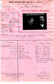
Police record (Peter McNamara), 23 January 1920
Peter McNamara had committed numerous offences such as stealing, whilst drunk. In April 1914 he was charged with attempting to murder Sarah Bass, a housemaid at the Mount Bute steep station. He was found not guilty due to insanity caused by alcoholismPrison record for Peter McNamara, prisoner registered number 33640, giving details of the prisoner, his crimes and the dates and places of his trials.english speaking prisoner, peter mcnamara, drunk, larceny, attempted murder -
 Orbost & District Historical Society
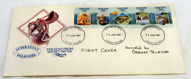
first day cover, Connell, Lee, June 1987
The Man from Snowy River" is a poem by Australian bush poet Banjo Paterson. It was first published in The Bulletin, an Australian news magazine, on 26th April 1890. The poem tells the story of a horseback pursuit to recapture the colt of a prizewinning racehorse that escaped from its paddock and is living wild with the brumbies (wild horses) of the mountain ranges. Eventually the brumbies descend a seemingly impassably steep slope, at which point the assembled riders give up the pursuit, except the young hero, who spurs his pony down the "terrible descent" to catch the mob.Two characters mentioned in the early part of the poem are featured in previous Paterson poems; "Clancy of the Overflow" and Harrison from "Old Pardon, Son of Reprieve".The town of Orbost is situated on the Snowy River and the town has always been "the heart of Snowy River country".A first day cover for "The Man From Snowy River" stamps. There is a picture of a saddle in the top left-hand corner. There is a strip 5 stamps on the envelope and it has been stamped at Orbost Post Office. This strip has 5 scenes based on the Banjo Patterson legendary poem by the same name. The stamps include: At The Station, Mountain Bend, The Terrible Descent, At Their Heels and Brought Them Back.first-day-cover man-from-snowy-river stamps philately -
 Orbost & District Historical Society
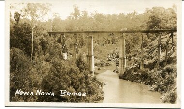
black and white photograph, first half 20th century
This appears to be the Boggy Creek bridge and to have been taken at Nowa Nowa. The Boggy Creek Bridge was built in 1916 as part of the Bairnsdale to Orbost extension to the main Gippsland Railway, and is situated in the middle of the township of Nowa Nowa, crossing a steep-sided and well-timbered creek-valley. This section of the line closed in 1987.This bridge plays a major part in the identity and history of the town of Nowa Nowa, since Boggy Creek’s steep sided valley divides the township into two components. It is part of the East Gippsland Railway line.A black / white photograph / postcard of a tall railway bridge, with concrete pylons in the centre,There is a creek below.on front - bottom left - " NOWA NOWA BRIDGE"boggy-creek-railway-bridge nowa-nowa railway-bridge east-gippsland-railway orbost-bairnsdale-railway -
 Orbost & District Historical Society
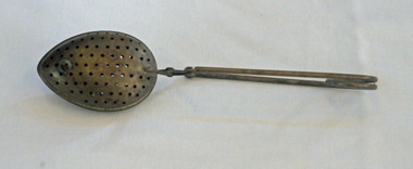
tea infuser, first half 20th century?
A tea infuser is a device in which loose, dried tea leaves are placed for steeping or brewing. The tea infuser gained popularity in the first half of the 19th century. This item is an example of a commonly used kitchen utensil not in common use today. It has been superseded by the teabag.A tea infuser spoon which looks like a small covered spoon. It is made from metal (brass?) with small holes. It has a narrow tapered handle.tea-infuser beverages kitchenware -
 Marysville & District Historical Society
Photograph (item) - Colour tinted photograph, Valentine Publishing Co. Pty. Ltd, The Road to Cumberland Valley, Marysville. No. 1, 1923-1963
An early colour tinted photograph of the intersection of the Buxton Marysville Road and the Marysville-Wood's Point Road.An early photograph of the Buxton Marysville Road and the Marysville-Wood's Point Road intersection. The Marysville-Buxton Road joins the Maroondah Highway which leads to Alexandra. The Marysville-Woods Point Road was originally part of the Yarra Track, constructed in the early 1860s to provide access between Healesville and the Woods Point Goldfields. Despite the steep terrain and engineering difficulties, the Yarra Track soon became a busy route used by pack horses, horse-drawn drays, and wagons. Today this sealed mountain road is a popular scenic drive between Marysville and Warburton. On the right of the photograph can be seen 'The Crossways Hotel' which is circa 1920 and one of the oldest buildings still standing in Marysville. 'The Crossways Hotel' survived the 2009 Black Saturday bushfires, through the efforts of the owner using buckets of water from the nearby Steavenson River. In the background can be seen the Poontawan Guest House which later became the Marysville Chalet Guest House which was on the site of the original Steavenson's Hotel. That guest house no longer exists and the Christ Church stands on the land where the guest house once stood. This photograph was published by the Valentine Publishing Co Pty. Ltd as a souvenir of Marysville.marysville, victoria, marysville chalet guest house, crossways hotel, christ church marysville, poontawan guest house, steavenson's hotel, valentine publishing co, souvenir, yarra track, wood's point road, mining, buxton-marysville road, marysville-wood's point road, maroondah highway, alexandra -
 Marysville & District Historical Society
Photograph (item) - Black and white photograph, Valentine Publishing Co. Pty. Ltd, The Old Ford, Marysville No.9, 1923-1963
An early black and white photograph of the old ford in Marysville, Victoria.An early photograph of the bridge at the end of the main street in Marysville which is near the Buxton-Marysville Road and the Marysville-Wood's Point Road intersection. The Marysville-Buxton Road joins the Maroondah Highway which leads to Alexandra. The Marysville-Woods Point Road was originally part of the Yarra Track, constructed in the early 1860s to provide access between Healesville and the Woods Point Goldfields. Despite the steep terrain and engineering difficulties, the Yarra Track soon became a busy route used by pack horses, horse-drawn drays, and wagons. Today this sealed mountain road is a popular scenic drive between Marysville and Warburton. This photograph was published by the Valentine Publishing Co Pty. Ltd as a souvenir of Marysville.marysville, victoria, valentine publishing co, souvenir, buxton-marysville road, marysville-wood's point road, maroondah highway, alexandra, yarra track, mining -
 Marysville & District Historical Society
Photograph (item) - Colour tinted photograph, Valentine Publishing Co. Pty. Ltd, The Old Ford, Marysville No.9, 1923-1963
An early colour tinted photograph of the old ford in Marysville, Victoria. This photograph was published by the Valentine Publishing Co Pty. Ltd. as a souvenir of Marysville.An early photograph of the bridge at the end of the main street in Marysville which is near the Buxton-Marysville Road and the Marysville-Wood's Point Road intersection. The Marysville-Buxton Road joins the Maroondah Highway which leads to Alexandra. The Marysville-Woods Point Road was originally part of the Yarra Track, constructed in the early 1860s to provide access between Healesville and the Woods Point Goldfields. Despite the steep terrain and engineering difficulties, the Yarra Track soon became a busy route used by pack horses, horse-drawn drays, and wagons. Today this sealed mountain road is a popular scenic drive between Marysville and Warburton. This photograph was published by the Valentine Publishing Co Pty. Ltd as a souvenir of Marysville.marysville, victoria, valentine publishing co, souvenir, buxton-marysville road, marysville-wood's point road, maroondah highway, alexandra, yarra track, mining -
 Marysville & District Historical Society
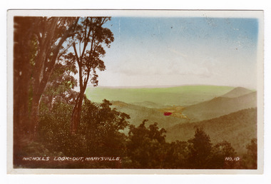
Photograph (item) - Colour tinted photograph, Valentine Publishing Co. Pty. Ltd, Nicoll's Lookout, Marysville No.10, 1923-1963
An early colour tinted photograph of Nicholl's Look-out near Marysville in Victoria. This photograph was published by the Valentine Publishing Co Pty. Ltd. as a souvenir of Marysville.An early colour tinted photograph of Nicholl's Look-out near Marysville in Victoria. This lookout is situated on the Marysville-Wood's Point Road. The Marysville-Woods Point Road was originally part of the Yarra Track, constructed in the early 1860s to provide access between Healesville and the Woods Point Goldfields. Despite the steep terrain and engineering difficulties, the Yarra Track soon became a busy route used by pack horses, horse-drawn drays, and wagons. Today this sealed mountain road is a popular scenic drive between Marysville and Warburton. This photograph was published by the Valentine Publishing Co Pty. Ltd. as a souvenir of Marysville.marysville, victoria, valentine publishing co, souvenir, nicholl's look-out, mining, yarra track -
 Marysville & District Historical Society
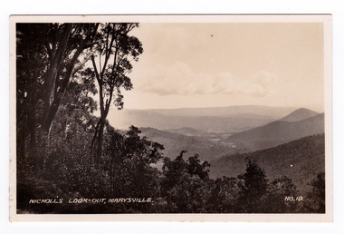
Photograph (item) - Black and white photograph, Valentine Publishing Co. Pty. Ltd, Nicoll's Lookout, Marysville No.10, 1923-1963
An early black and white photograph of Nicholl's Look-out near Marysville in Victoria.An early black and white photograph of Nicholl's Look-out near Marysville in Victoria. This lookout is situated on the Marysville-Wood's Point Road. The Marysville-Woods Point Road was originally part of the Yarra Track, constructed in the early 1860s to provide access between Healesville and the Woods Point Goldfields. Despite the steep terrain and engineering difficulties, the Yarra Track soon became a busy route used by pack horses, horse-drawn drays, and wagons. Today this sealed mountain road is a popular scenic drive between Marysville and Warburton. This photograph was published by the Valentine Publishing Co Pty. Ltd. as a souvenir of Marysville.marysville, victoria, valentine publishing co, souvenir, nicholl's look-out, mining, yarra track -
 Marysville & District Historical Society
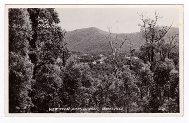
Postcard (item) - Black and white postcard, Valentine Publishing Co. Pty. Ltd, View From Jock's Lookout, Marysville. V. 21, 1923-1963
An early black and white photograph of the view from Jock's Lookout of Marysville in Victoria. An early black and white photograph of the view from Jock's Lookout of Marysville in Victoria. Jock's Lookout is situated on the Marysville-Wood's Point Road. The Marysville-Woods Point Road was originally part of the Yarra Track, constructed in the early 1860s to provide access between Healesville and the Woods Point Goldfields. Despite the steep terrain and engineering difficulties, the Yarra Track soon became a busy route used by pack horses, horse-drawn drays, and wagons. Today this sealed mountain road is a popular scenic drive between Marysville and Warburton. This postcard was published by the Valentine Publishing Co. Pty. Ltd. as a souvenir of Marysville.VALENTINE'S/ POST CARD/ A GENUINE PHOTOGRAPHjock's lookout, marysville, victoria, postcard, valentine publishing co, souvenir, marysville-wood's point road, yarra track, mining, warburton -
 Marysville & District Historical Society
Postcard (item) - Black and white postcard, Valentine Publishing Co. Pty. Ltd, View From Jock's Lookout, Marysville. V. 21, 1923-1963
An early black and white photograph of the view from Jock's Lookout of Marysville in Victoria.An early black and white photograph of the view from Jock's Lookout of Marysville in Victoria. Jock's Lookout is situated on the Marysville-Wood's Point Road. The Marysville-Woods Point Road was originally part of the Yarra Track, constructed in the early 1860s to provide access between Healesville and the Woods Point Goldfields. Despite the steep terrain and engineering difficulties, the Yarra Track soon became a busy route used by pack horses, horse-drawn drays, and wagons. Today this sealed mountain road is a popular scenic drive between Marysville and Warburton. This postcard was published by the Valentine Publishing Co. Pty. Ltd. as a souvenir of Marysville.VALENTINE'S/ POST CARD/ A GENUINE PHOTOGRAPHjock's lookout, marysville, victoria, postcard, valentine publishing co, souvenir, marysville-wood's point road, yarra track, mining, warburton -
 Marysville & District Historical Society
Postcard (item) - Black and white postcard, Valentine Publishing Co. Pty. Ltd, View From Nicholl's Lookout, Marysville. V. 43, 1923-1963
An early black and white photograph of the view of Marysville in Victoria taken from Nicholl's Lookout.An early black and white photograph of the view of Marysville in Victoria taken from Nicholl's Lookout. This lookout is situated on the Marysville-Wood's Point Road. The Marysville-Woods Point Road was originally part of the Yarra Track, constructed in the early 1860s to provide access between Healesville and the Woods Point Goldfields. Despite the steep terrain and engineering difficulties, the Yarra Track soon became a busy route used by pack horses, horse-drawn drays, and wagons. Today this sealed mountain road is a popular scenic drive between Marysville and Warburton. This postcard was published by the Valentine Publishing Co Pty. Ltd. as a souvenir of Marysville.VALENTINE'S/ POST CARD/ A GENUINE PHOTOGRAPHmarysville, nicholl's lookout, victoria, postcard, valentine publishing co, souvenir -
 Marysville & District Historical Society
Photograph (item) - Black and white photograph, Murray Views, Murray Views No. 47. Nicholl's Lookout, Marysville, Vic, Post 1929
An early black and white photograph of the view of Marysville taken from Nicholl's Lookout.An early black and white photograph of the view of Marysville taken from Nicholl's Lookout. Nicholl's Lookout is situated on the Marysville-Wood's Point Road. The Marysville-Woods Point Road was originally part of the Yarra Track, constructed in the early 1860s to provide access between Healesville and the Woods Point Goldfields. Despite the steep terrain and engineering difficulties, the Yarra Track soon became a busy route used by pack horses, horse-drawn drays, and wagons. Today this sealed mountain road is a popular scenic drive between Marysville and Warburton. This photograph was produced by Murray Views in Gympie, Queensland as a souvenir of Marysville. nicholl's lookout, marysville, victoria, photograph, murray views, souvenir, marysville-wood's point road, yarra track, mining, warburton -
 Marysville & District Historical Society
Postcard (item) - Colour tinted postcard, Nucolorvue Productions, Nicholl's Lookout, Marysville, 1950's
An early colour photograph of the view of Marysville in Victoria taken from Nicholl's Lookout.An early colour photograph of the view of Marysville in Victoria taken from Nicholl's Lookout. Nicholl's Lookout is situated on the Marysville-Wood's Point Road. The Marysville-Woods Point Road was originally part of the Yarra Track, constructed in the early 1860s to provide access between Healesville and the Woods Point Goldfields. Despite the steep terrain and engineering difficulties, the Yarra Track soon became a busy route used by pack horses, horse-drawn drays, and wagons. Today this sealed mountain road is a popular scenic drive between Marysville and Warburton. This postcard was produced by Nucolorvue Productions in Elwood, Victoria as a souvenir of Marysville.POST CARD NUCOLORVUE PRODUCTIONS, ELWOOD, VICTORIAnicholl's lookout, marysville, victoria, nucolorvue productions, postcard, souvenir, marysville-wood's point road, yarra track, mining, warburton -
 Marysville & District Historical Society
Postcard (item) - Black and white postcard, Marysville & District Historical Society Inc, Bullock Teams at the Dump, Woods Point Road, 1993
A black and white photograph of bullock teams at the Log Dump at on the Wood's Point Road.A black and white photograph of bullock teams at the Dump at on the Wood's Point Road. The Marysville-Woods Point Road was originally part of the Yarra Track, constructed in the early 1860s to provide access between Healesville and the Woods Point Goldfields. Despite the steep terrain and engineering difficulties, the Yarra Track soon became a busy route used by pack horses, horse-drawn drays, and wagons. Today this sealed mountain road is a popular scenic drive between Marysville and Warburton. This postcard was produced by the Marysville Historical Society as a souvenir of Marysville.YESTERYEAR POSTCARDS AFFIX/ STAMP/ HERE BULLOCK TEAMS AT THE DUMP,/ WOODS POINT ROAD. C Marysville Historical Society, 1993marysville, bullock teams, woods point road, victoria, marysville historical society, postcard, souvenir, yesteryear postcards, marysville-wood's point road, yarra track, healesville, mining, timber mills, warburton -
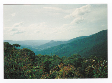
 Marysville & District Historical Society
Postcard (item) - Colour postcard, Nucolorvue Productions Pty. Ltd, Mystic Mountains-Marysville, Pre 2009
A colour photograph of the view of the mountains surrounding Marysville in Victoria from Nicholl's Lookout.A colour photograph of the view of the mountains surrounding Marysville in Victoria from Nicholl's Lookout. The mountains surrounding Marysville are known as the Mystic Mountains and Nicoll's Lookout is on the Marysville-Wood's Point Road. The Marysville-Woods Point Road was originally part of the Yarra Track, constructed in the early 1860s to provide access between Healesville and the Woods Point Goldfields. Despite the steep terrain and engineering difficulties, the Yarra Track soon became a busy route used by pack horses, horse-drawn drays, and wagons. Today this sealed mountain road is a popular scenic drive between Marysville and Warburton. This postcard was produced by Nucolorvue Productions in Elwood, Victoria as a souvenir of Marysville.This postcard was produced by Nucolorvue Productions Pty. Ltd. as a souvenir of Marysville.NICHOLS LOOKOUT/ Marysville Victoria NU-COLOR-VUE/ AUSTRALIA'S NATIONAL POSTCARD COMPANY AFFIX/ STAMP/ HERE/ 17MA019/ NCV 9603 POSTCODE COPYRIGHT/ Nucolorvue Productions Pty. Ltd.,/ Telephone: (03) 560-1788/ Made in Australiamarysville, mystic mountains, nicholl's lookout, victoria, nucolorvue productions, postcard, souvenir, marysville-wood's point road, yarra track, healesville, mining, warburton -
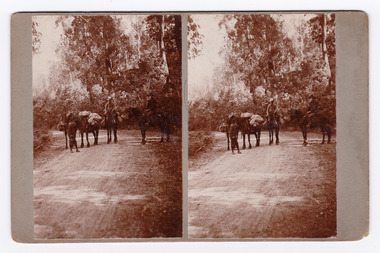 Marysville & District Historical Society
Photograph (Item) - Black and white bi-focal image, Unknown
An early black and white bi-focal image of men and packhorses on the Marysville-Wood's Point Road in Marysville in Victoria.An early black and white bi-focal image of men and packhorses on the Marysville-Wood's Point Road in Marysville in Victoria. This is now known as the Marysville-Wood's Point Road. The Marysville-Woods Point Road was originally part of the Yarra Track, constructed in the early 1860s to provide access between Healesville and the Woods Point Goldfields. Despite the steep terrain and engineering difficulties, the Yarra Track soon became a busy route used by pack horses, horse-drawn drays, and wagons. Today this sealed mountain road is a popular scenic drive between Marysville and Warburton.Packhorses on Wood'spoint Road/ Marysville/ Victoriapackhorses, wood's point road, marysville-wood's point road, marysville, victoria, yarra track, healesville, wood's point goldfields, warburton -
 Marysville & District Historical Society
Document (Item) - Newspaper article, The Argus, New Tourist Road. Marysville to Wood's Point Magnificent Forest Scenery, 02-1924
A newspaper article regarding the opening of the Marysville-Wood's Point Road in February 1924.A newspaper article regarding the opening of the Marysville-Wood's Point Road in February 1924. The Marysville-Woods Point Road was originally part of the Yarra Track, constructed in the early 1860s to provide access between Healesville and the Woods Point Goldfields. Despite the steep terrain and engineering difficulties, the Yarra Track soon became a busy route used by pack horses, horse-drawn drays, and wagons. Today this sealed mountain road is a popular scenic drive between Marysville and Warburton.marysville-wood's point road, yarra track, healesville, wood's point goldfields, warburton, the argus -
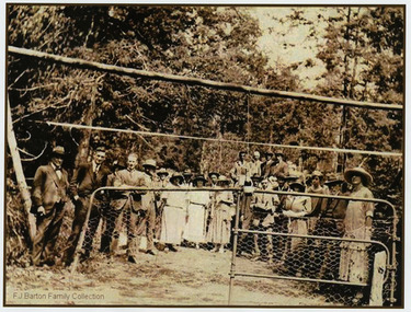 Marysville & District Historical Society
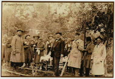
Photograph (Item) - Black and white photograph, 05-02-1924
An early black and white photograph of the ceremonial re-opening of the Marysville-Wood's Point Road in 1924.An early black and white photograph of the ceremonial re-opening of the Marysville-Wood's Point Road in 1924. The Marysville-Woods Point Road was originally part of the Yarra Track, constructed in the early 1860s to provide access between Healesville and the Woods Point Goldfields. Despite the steep terrain and engineering difficulties, the Yarra Track soon became a busy route used by pack horses, horse-drawn drays, and wagons. Today this sealed mountain road is a popular scenic drive between Marysville and Warburton.F.J. Barton Family Collectionmarysville-wood's point road, marysville, wood's point goldfields, healesville, yarra track, warburton -
 Marysville & District Historical Society
Photograph (Item) - Black and white photograph, 05-02-1924
An early black and white photograph of the ceremonial re-opening of the Marysville-Wood's Point Road in 1924.An early black and white photograph of the ceremonial re-opening of the Marysville-Wood's Point Road in 1924. The Marysville-Woods Point Road was originally part of the Yarra Track, constructed in the early 1860s to provide access between Healesville and the Woods Point Goldfields. Despite the steep terrain and engineering difficulties, the Yarra Track soon became a busy route used by pack horses, horse-drawn drays, and wagons. Today this sealed mountain road is a popular scenic drive between Marysville and Warburton.F.J. Barton Family Collectionmarysville-wood's point road, marysville, wood's point goldfields, healesville, yarra track, warburton -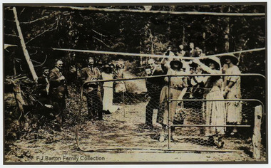
 Marysville & District Historical Society
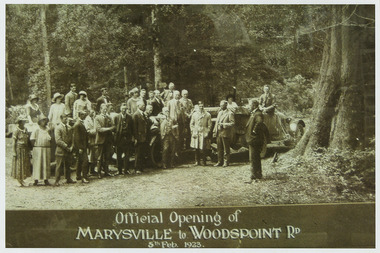
Photograph (Item) - Black and white photograph, Official Opening of MARYSVILLE to WOODSPOINT RD 5th Feb, 1923, 05-02-1924
An early black and white photograph which was taken after the ceremonial re-opening of the Marysville-Wood's Point Road in 1924. The date of 1923 on the photograph is incorrect.An early black and white photograph which was taken after the ceremonial re-opening of the Marysville-Wood's Point Road in 1924. The date of 1923 on the photograph is incorrect. The Marysville-Woods Point Road was originally part of the Yarra Track, constructed in the early 1860s to provide access between Healesville and the Woods Point Goldfields. Despite the steep terrain and engineering difficulties, the Yarra Track soon became a busy route used by pack horses, horse-drawn drays, and wagons. Today this sealed mountain road is a popular scenic drive between Marysville and Warburton.Official Opening of/ MARYSVILLE to WOODSPOINT RD/ 5th Feb, 1923marysville-wood's point road, marysville, wood's point goldfields, healesville, yarra track, warburton, the argus -
 Bendigo Historical Society Inc.
Slide - DIGGERS & MINING. DIGGERS AND MINERS, c1800s
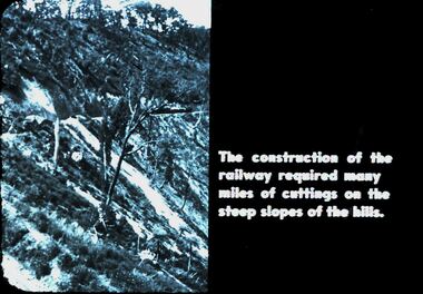
Diggers & Mining. Diggers and Miners. The construction of the railway required many miles of cuttings on the steep slopes of the hills. Photo shows that the hills are approx. 45 degrees. Markings: 24 994.5 WAL. Used as a teaching aid.hanimounteducation, tertiary, goldfields -
 Bendigo Historical Society Inc.
Slide - DIGGERS & MINING. DIGGERS AND MINERS, 1850s
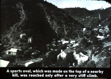
Diggers & Mining. Diggers and Miners. A sports oval, which was made on the top of the nearby hill, was reached only after a very stiff climb. Picture shows the very steep track which you would have to walk to reach the oval. Markings: 51 994.5 WAL. Used as a teaching aid.hanimounteducation, tertiary, goldfields -
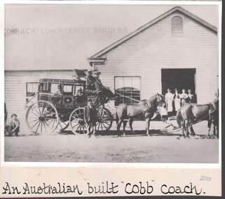 Bendigo Historical Society Inc.
Photograph - COBB & CO., AN AUSTRALIAN BUILT 'COBB' COACH
black and white image ( copy ) : image shows Cobb & Co., coach, passengers, men up front, team of horses. Coach is standing in front of weatherboard building, large open doorway, four men standing in it. On bottom : An Austrralian built 'Cobb' coach. / Sign on roof states 'Cobb & Co Ltd Coach & Buggy Builders .- Coachworks were established in Bathurst, Bourke, Goulburn, Hay and Charleville, business boomed and the name of ‘Cobb & Co’ became the byword for cutting edge communications and transport facilities across eastern Australia.''Cobb & Co Factories Shortly after its arrival in Bathurst, Cobb & Co established the first of five coach works, both to supply its own transportation and as a commercial venture. The factory was situated at the Black Bull Inn, on the corner of Howick and Bentinck Streets, and a variety of prize-winning horse-drawn conveyances were built on the site (including an unsuccessful single-wheel vehicle to cater for rough and steep country). The factory was transferred to new premises in William Street in 1876, by which time Cobb & Co factories were also operating in Hay, Goulburn and Bourke in New South Wales and at Charleville in Queensland.///The horses are wearing blinkersbusiness, transport, cobb & co., cobb & co.