Showing 72 items
matching strip shopping centre
-
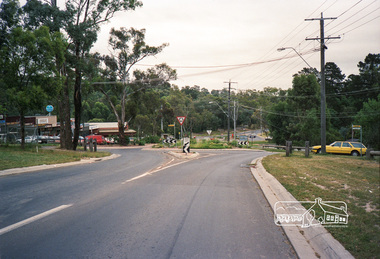 Eltham District Historical Society Inc
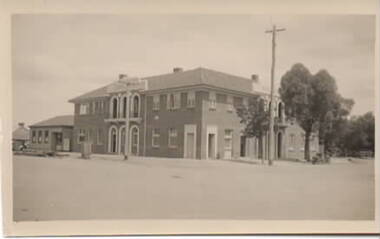
Photograph, Research Shops, Feb 1990, 1990
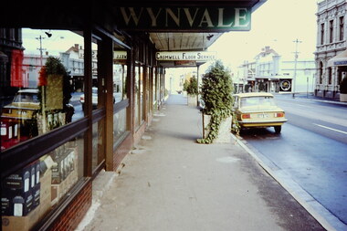
Research Shopping Centre and precinct including roundabout at Ingrams Road.Roll of 35mm colour negative film, 4 stripsFuji 100main road, research (vic.), roundabouts, shops -
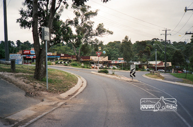 Eltham District Historical Society Inc
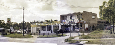
Photograph, Research Shops, Feb 1990, 1990
Research Shopping Centre and precinct including roundabout at Ingrams Road.Roll of 35mm colour negative film, 4 stripsFuji 100main road, research (vic.), roundabouts, shops -
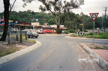 Eltham District Historical Society Inc
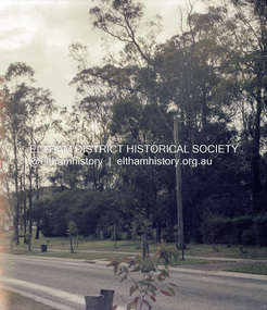
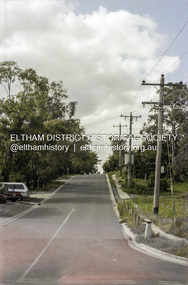
Photograph, Research Shops, Feb 1990, 1990
Research Shopping Centre and precinct including roundabout at Ingrams Road.Roll of 35mm colour negative film, 4 stripsFuji 100main road, research (vic.), roundabouts, shops -
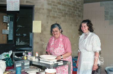 Eltham District Historical Society Inc
Negative - Photograph, Grace Mitchell and Ursula Dors, Pottery Class, Eltham Living and Learning Centre, Oct. 1988
Grace Mitchell, a talented artist in later life and baker managed a pastry shop business near the corner of Mt Pleasant and Main Roads Eltham in the 1950’s. Shortly after her marriage to Arthur Mitchell in 1948 he had an accident that caused a head injury and was unable to work. Grace realised she needed to be home to care for her husband as well as earn an income. She managed the bureaucracy of council permits, made modifications to her home with savings to get the business off the ground without having to borrow money. Grace and Arthur were avid gardeners and would grow, wash and mince vegetables for pasties while Grace hand made and rolled the pastry. They cooked and minced their own meat for the pies and the fruit for the sweet pies came from their orchard at the rear of the property. She also baked scones and cakes. Grace operated her pastry shop for over 16 years. She supported the Shillinglaw Cottage Preservation Campaign to preserve the cottage through its Flavour of Eltham community cookbook published in 1964 and hosted cooking classes in the new Living and Learning Centre. Grace Mitchell passed away aged 95 years in 2011.Roll of 35mm colour negative film, 6 strips and associated colour print 10 x 15 cmFuji 100classes, eltham, living and learning centre, pottery class, eltham living and learning centre, grace mitchell, ursula dors, teaching, learning -
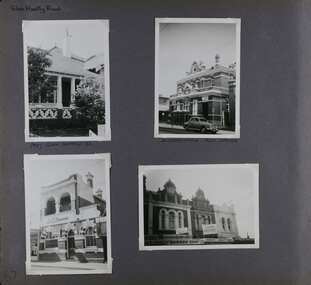 Glen Eira Historical Society
Album - Album page, Glen Huntly Road, Circa 1972
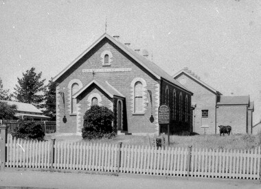
This photograph is part of the Caulfield Historical Album 1972. This album was created in approximately 1972 as part of a project by the Caulfield Historical Society to assist in identifying buildings worthy of preservation. The album is related to a Survey the Caulfield Historical Society developed in collaboration with the National Trust of Australia (Victoria) and Caulfield City Council to identify historic buildings within the City of Caulfield that warranted the protection of a National Trust Classification. Principal photographer thought to be Trevor Hart, member of Caulfield Historical Society. Most photographs were taken between 1966-1972 with a small number of photographs being older and from unknown sources. All photographs are black and white except where stated, with 386 photographs over 198 pages. The Former Elsternwick Post Office is on the Victorian Heritage Register H0640 with a full significance statement and also HO29 with the City of Glen Eira. Much of the Glen Huntly Road heritage retail strip is heritage listed in HO72 with the City of Glen Eira.Page 67 of Photograph Album with four photographs (three portrait and one landscape) of different properties on Glen Huntly Road - a house, Post Office, ANZ Bank and shops.Hand written: Glen Huntly Road [top left] / 1027 GLEN HUNTLY RD [under top left photo] / ELSTERNWICK POST OFFICE [under top right photo] / 67 [bottom left] trevor hart, glen huntly road, elsternwick, shops, caulfield, post offices, glenhuntly road, banks, brick houses, shopping centres -
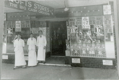 City of Moorabbin Historical Society (Operating the Box Cottage Museum)
Photograph - Black & White, Crofts Grocery 395 Centre Rd Bentleigh c1937, c1937
... was one of the shops in the Centre Road Bentleigh shopping strip ...After the extension of the Railway line from Caulfield to Mordialloc 1880's the shopping centre moved from the Tucker Rd end to around the East Brighton (Bentleigh) Station area of Centre Road. A variety of shops, forges, estate agents, Coles' and Fossey's variety stores, a Hoyts picture theatre, butchers, traded in Centre Rd. Crofts was one many grocery stores along the strip. Crofts Stores was established by Archibald Crofts (1875-1942) as a single grocery store in South Melbourne. It eventually expanded to include 137 branches throughout Victoria, trading as Crofts Stores. The Lees family had established a Seedling Nursery in Thomas St that has continued until the land sold 2018 for housing development.Crofts Grocery Store was one of the shops in the Centre Road Bentleigh shopping strip that were established after the arrival of the train line 1881Black & White photograph of 3 men outside Crofts Grocery Store 395 Centre Rd Bentleigh c 1937 Mr Jack Lees is centre.Handwritten informationcrofts grocery store bentleigh, lees jack, mordialloc railway line, centre road bentleigh, smith j l, smith mary ann, stanley helen, smith vic, smith harry redvers, chaff cutter, horse drawn carts, toll gates brighton, motor cars 1900, steam engines, early settlers, bentleigh, parish of moorabbin, city of moorabbin, county of bourke, moorabbin roads board, shire of moorabbin, henry dendy's special survey 1841, were j.b., bent thomas, o'shannassy john, king richard, charman stephen, highett william, ormond francis, maynard dennis, market gardeners, vineyards -
 Whitehorse Historical Society Inc.
Article, Traders miss foot traffic, 2010
... Activity Centre, which occupies the shopping strip on the east side... Centre, which occupies the shopping strip on the east side ...Article on the reduction of custom for the Nunawading Activity Centre, which occupies the shopping strip on the east side of Springvale Road opposite the new Nunawading Railway Station, owing to the relocation of the station.Article on the reduction of custom for the Nunawading Activity Centre, which occupies the shopping strip on the east side of Springvale Road opposite the new Nunawading Railway Station, owing to the relocation of the station.Article on the reduction of custom for the Nunawading Activity Centre, which occupies the shopping strip on the east side of Springvale Road opposite the new Nunawading Railway Station, owing to the relocation of the station.nunawading shopping centre, nunawading railway station, nunawading activity centre -
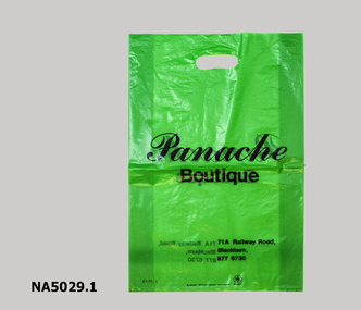 Whitehorse Historical Society Inc.
Functional object - Shopping Bags
Plastic shopping bags used by four business in the Blackburn Shopping Centre. All have advertisement for the different shops printed on them including telephone number.These begs were used to carry purchases and advertise the business.1 Green plastic carry bag from Panache Boutique, Blackburn .2 Black and gold stripped carry bag from Victor's Men's Fashion shop, Blackburn .3 White, red and blue plastic carry bag from Anstees, Blackburn .4 White carry bag with green writing from Love Fortyvictor's fashion for men, anstees supa valu, love forty sporting apparel, blackburn shopping strip, shopping, panache boutique -
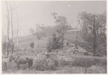 Mt Dandenong & District Historical Society Inc.
Photograph, The Busy Corner, 1907
View of Jeeves Saddle in 1907 showing everyday life and including important people and businesses from early settlement - Dodd's grocery and meat cutting carts; Beulah tea Rooms/Post Office; Mrs Hand, Fred Jeeves, Theo Hand.This photograph has a detailed inscription on the back handwritten by John Lundy-Clarke in 1974.“Jeeves Saddle” in 1907. Isaac Jeeves special strip of land Crown Allotment “C” 7 chains wide, lay between the sledge load of pea stalks and the far end of the verandah on Mrs Hand’s “Beulah Tea Rooms” which soon afterwards became the Mt Dandenong North Post Office. The coach road came up from the right behind the tall stump. The big woman in black was Mrs Hand. The wagon at the shop was Dodd’s grocery cart. The nearer wagon was the first coach on the mountain which had belonged to Briarty. The small cart was Dodd’s meat cutting cart. The elm trees are in the centre of the picture and above them is Price’s sign advertising their shop and newsagency. The big house is “Mountjoy” burnt 1975. Walker’s house is among the big trees left centre. Boy at horse’s head is Fred Jeeves. Boy on sledge is Theo Hand. The horse is “Blossom”. Barbers Road goes to the left from behind the elm trees.jeeves, theo hand, fred jeeves, isaac jeeves, barbers road, beulah tea rooms, post office, mount dandenong north, mt dandenong north, kalorama, coach, mountjoy -
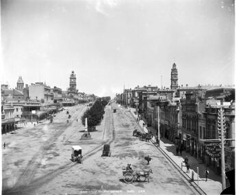 Ballarat Tramway Museum
Photograph - Digital image, Fred Hardie, turt St Ballarat, looking west from Grenville, 1892
Yields information about the appearance of Sturt St and the horse tram track near Grenville St c1892Digital image from the George Washington Wilson and Co. photographic collection held by the University of Aberdeen - see related documents for information and their website for reproduction permissions. It notes that Fred Hardie was sent to Australia in 1892. There are some 41 Ballarat images available on the website. Sturt St Ballarat, looking west from Grenville St towards the Post Office and Town Hall. Shows the horse tram track and the median strip - photo number GB 0231 MS 3792/A2811. Has a number of horse cabs in the background, the 8-hour monument. In the bottom right-hand corner, has the "Summerscales Great shop of Novelties". In the centre of the photograph is a horse tram turning from Lydiard St north into Sturt St. See: https://www.abdn.ac.uk/special-collections/about-george-washington-wilson-383.php - accessed 29-12-2017.trams, tramways, sturt st, horse trams, horse cabs, grenville st -
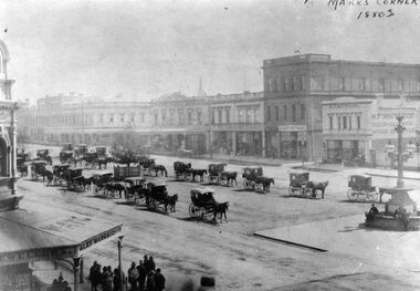 Ballarat Tramway Museum
Photograph - Black & White Photograph/s, 1880's
Yields information about the streetscape of Sturt St prior to the formation of the Sturt St median strip, shows horse cabs and buildings on the north side of the street.Black and White copy photograph of a Gold Museum photograph - Sturt St - Marks Corner, 1880's, prior to the formation of the median strip. Has many horse drawn cabs in the centre median strip. Buildings in image - and other shops. Collected by Alan Bradley from the Gold Museum early 1980's. Used in The Golden City and its Tramways - page 11.tramways, trams, sturt st, marks corner -
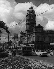 Ballarat Tramway Museum
Photograph - Black & White Photograph/s, Jim Seletto, Feb. 1958
Yields information about the appearance of Sturt St at the time of Ballarat Begonia Festival, 1957 - the flowers in the medium strip, the tram and the shoppers in particular the women.Black and white photograph of Ballarat No. 14 west bound in Sturt St during the 1957 Begonia Festival with the Town Hall (with a Begonia Festival sign on it), and other buildings in the background. Has the Australian Mutual Life Building, the Odeon Theatre buildings. In the centre median strip, there is a large arrangement of flower beds and many women shoppers crossing the road, motor vehicles and a lady on a bicycle. No. 14 has the destination of Haddon St via Drummond Nth. Festoon lighting is strung out along the street.On rear in red ink "Ballarat Car 14 Sturt St B'rat Summer '57" and the stamp of Jim Seletto.tramways, trams, sturt st, begonia festival, town hall, shoppers, tram 14 -
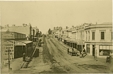 Kew Historical Society Inc
Photograph, J F C Farquhar, High Street, Kew, 1891
At the beginning of the 1890s, the Kew businessman and Town Councillor, Henry Kellett, commissioned J.F.C. Farquhar to photograph scenes of Kew. These scenes included panoramas as well as pastoral scenes. The resulting set of twelve photographs was assembled in an album, Kew Where We Live, from which customers could select images for purchase.The preamble to the album describes that the photographs used the ‘argentic bromide’ process, now more commonly known as the gelatine silver process. This form of dry plate photography allowed for the negatives to be kept for weeks before processing, hence its value in landscape photography. The resulting images were considered to be finely grained and everlasting. Evidence of the success of Henry Kellett’s venture can be seen today, in that some of the photographs are held in national collections.It is believed that the Kew Historical Society’s copy of the Kellett album is unique and that the photographs in the book were the first copies taken from the original plates. It is the first and most important series of images produced about Kew. The individual images have proved essential in identifying buildings and places of heritage value in the district.In 1891, High Street was the centre of commercial activity in the Borough of Kew. It was unpaved and edged with deep bluestone gutters, which were designed to channel the significant flow of storm water down the hill to and beyond the Junction. On either side of the entrance to the shopping strip are two cast iron gas lamps that provided the only public street lighting before the Post Office was reached. Most shops, including the Nicholas Brothers’ Junction Store featured cast iron verandas. Further up the hill, Dougherty’s Greyhound Hotel was by this stage a local institution. Apart from the horse-drawn tram, the main form of personal and commercial transport in this period remained the horse, horse and cart, or buggy.The panoramic view predates the widening of High Street in the 20th century, and thus includes the original alignment of buildings on the south side. These included Henry Kellett’s shop.High Street, Kewkew illustrated, kew where we live, photographic books, henry kellett, high street - kew (vic) -
 Kew Historical Society Inc
Slide - High Street, Kew, 1980
One of a group of slides taken by members of the Society of built heritage in Kew in 1979-80. The selection of subject matter reflects the priorities of the period. The colour of some slides has degraded.The slides represent a snapshot in time of built architecture in Kew, much of which has changed in the forty-plus period since they were created. 35mm colour transparency (slide) of the Kew shopping centre looking west towards Kew Junction in 1980.high street -- kew (vic.), commerce -- kew (vic.), shopping strips -- kew (vic.) -
 City of Kingston
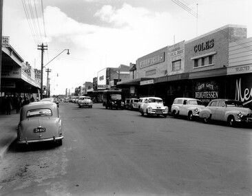
Photograph - Black and white, c. 1956
Black and white photograph depicting Centre Road Bentleigh, looking west. On the right hand side of the road there are two Coles stores. The one in the background is the newly opened store while the one in the foreground has been repurposed and is now a delicatessen. There are numerous cars parked on both sides of the road, including one that appears to be "double parked" on the right hand side of the road.Black and white photograph depicting Centre Road Bentleigh, looking west. On the right hand side of the road there are two Coles stores. The one in the background is the newly opened store while the one in the foreground has been repurposed and is now a delicatessen. There are numerous cars parked on both sides of the road, including one that appears to be "double parked" on the right hand side of the road.Handwritten in blue ink on a white sticker adhered to the reverse of the photograph: COLES BENTLEIGH c. 1956 / Centre Road looking west / The Old Coles store is in the foreground / and the new Coles is in the background.bentleigh, suburbs, shopping strip, cars -
 City of Kingston
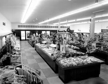
Photograph - Black and white, c. 1956
... . In this era, the Centre Road Bentleigh shopping strip provided ...This photograph depicts the interior of the Coles Variety Store within Bentleigh's Centre Road shopping precinct in 1956. Signage represents the pre decimal currency era. The Record Bar advertises the availability of standard and microgroove vinyl records.In this era, the Centre Road Bentleigh shopping strip provided consumers with access to many of the major retail outlets and provided for a wide range of shopping needs. By the 1960s, Chadstone Shopping Centres (opened 1960) and Southland (opened 1968) had been established which created changes to the way in which people shopped.Black and white photograph of interior of Coles Store in Centre Road, Bentleigh displaying prominent signage predating decimal currency. Other signage includes the Coles Record Bar indicating the sale of standard and microgroove vinyl records.Handwritten in blue ink: Coles Bentleigh Sep 1956 B Black printed text on white round adhesive sticker: 202 Handwritten in red ink: 80%shopping strip, strip shopping, bentleigh, city of moorabbin, coles stores -
 City of Kingston
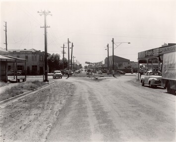
Photograph - Black and white, c. 1956
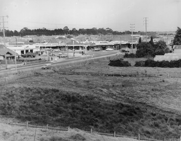
Strip shopping and ample parking were features of suburbs in the middle of the twentieth centuries. Cars were still considered a luxury, although that would soon change, and local, independent shops serviced local areas.During the post-war years, the municipality of Moorabbin experienced a population boom. The 'newcomers' were predominantly returnees from the war who were marrying and establishing families; those from the old inner-suburban areas who were moving away from rented premises to establish their own homes on cheap land. The 1950s were a time of immense growth for the area now known as City of Kingston.Black and white photograph of the intersection of Centre and East Boundary roads, Bentleigh East. Several cars are visible both in the foreground and background, and the intersection includes a roundabout. The street is lined with poles to carry electricity cables, and the roundabout is dotted with four poles for electric street lights.Handwritten in blue ink: 56 - 230 Handwritten in red ink: 82% Handwritten in black ink: Ch. 6shopping strip, cars, suburbs -
 City of Kingston
Photograph - Black and white, c. 1963
This image depicts the intersection of increasing urbanisation and the rural landscape that once made up the area now known as City of Kingston.Black and white photograph of the intersection of Warrigal Road and Centre Road, South Oakleigh, viewed from the reservoir. In the foreground are paddocks and in the background is a shopping strip, including a petrol station.Handwritten in blue ink on reverse: 2196 Handwritten in red ink on reverse: 100%oakleigh, roads, shopping strip, paddocks -
 City of Kingston
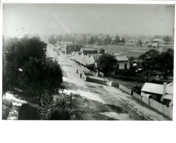
Photograph - Black and white, Percy Fairlam, c. 1910
Black and white image of Cheltenham in the early 20th Century depicts an almost idyllic life. This photo was taken by Percy Fairlam, who climbed a tall pine tree to achieve the aerial view. The tree was a well recognised feature of the Cheltenham skyline but was cut down some time before World War II.Cheltenham was established as a rural market gardening community. The development of the railway was crucial to the ongoing development of the area. Community life sprung up around the railway line which is evident in the proximity of shopping and leisure.Black and white image depicting aerial view down Charman Road, Cheltenham, including the unsealed road, level crossing and shopping centre. What appears to be a cricket pitch is located behind the shops.Handwritten in black ink on a red round sticker adhered to the reverse, and then crossed out: X14 Handwritten in blue ink on reverse: A8 Handwritten in red ink on reverse: 85%cheltenham, railway crossing, roads, housing, shopping strip -
 City of Kingston
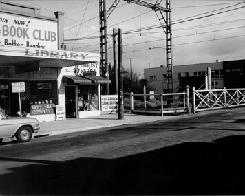
Photograph - Black and white, Public Transport Corporation, c. 1960
This image is part of a larger collection of images from the Public Transport Corporation displaying train stations and streetscapes in what is now the City of Kingston.The development of the railway was crucial to the ongoing development of the area. Community life sprung up around the railway line which is evident in the proximity of shopping and leisure.Black and white photograph of railway gates at Centre Road, Bentleigh.Black printed text on a small, round, white sticker on reverse: 227 Handwritten in red ink on reverse: 50% Black typed text on a strip of white paper stuck on reverse: Gates Centre Road Bentleigh / mid 1960 / $50 reproduction fee applies Blue ink stamped on reverse: COPYRIGHT / Public Transport Corporation / For re-ordering photographs / Please quote negative No H 3407 / Enquiries C/- PTC Photographic Unit / Telephone switchboard 619 1111bentleigh, railway crossing, trains, suburbs, shopping strip -
City of Kingston
Photograph - Colour, 29 January 1993
Bonbeach is a small beachside suburb located between Chelsea and Carrum. The station was opened in 1926 and was the last to be established in the group from Aspendale to Carrum. Urban growth began after World War II. State primary and high schools were opened in 1958 on land in Breeze Street that was once occupied by The Australian Glass Manufacturers. Immediately east of the school sites is the Patterson River Golf Club. The Bonbeach sports reserve has five ovals and is home to the Bonbeach football and baseball clubs. The suburb borders the Edithvale-Seaford Wetlands which is the remnant site of the Carrum Carrum swamp, once the home of the Bunurong people.Bonbeach was originally a seaside destination for holidaymakers and the housing comprised of holiday homes and gradually more permanent residents. It was not until 1926 that Bonbeach had its own railway station. From 1906 until the late 1940s sand was quarried on the east side of the railway line and used in the manufacture of glass. The Australian Glass Manufacturers sold this land in residential blocks and Bonbeach's permanent population spread from the coastal strip across to the other side of the railway line. Laminated colour aerial photograph of the suburb of Bonbeach and also the southern section of neighbouring Chelsea within the City of Kingston. The extent of this 1993 aerial image includes: Top left - Maury Road at the south end of the Chelsea shopping Centre; Top right - Scotch Parade Chelsea Bottom left - Monica Avenue in Bonbeach; Bottom right - Patterson River Golf Club. Landmarks include St Joseph's Church and Primary School, Chelsea Primary School, Bonbeach Station, Bonbeach Fotball Club sports playing fields and Bonbeach Life Saving Club. The Edithvale Wetlands is featured prominently to the right-hand side of the image. Black typed writing on white adhesive label: No. 6662 Black typed writing on white adhesive label: 26E/6662, 29/1/93, 4.25 pm Black typed writing on white adhesive label: 29-1-93 Black typed writing on white adhesive label: P000109 Circular yellow adhesive sticker bonbeach, chelsea -
 City of Kingston
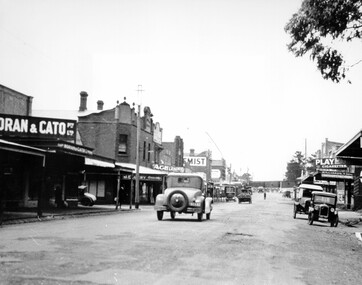
Photograph - Black and white, c. 1925
This image explores the relationship between the train lines and community development. Cheltenham's retail centre is connected to the train station.Black and white image of Charman Road, Cheltenham, depicting a car and truck travelling toward the level crossing near the train station. There is another car already waiting at the crossing gates. Cars are parked on either side of the road along a shopping strip.Black printed text on a white round sticker adhered to the reverse: 141 Handwritten in red ink on reverse: 50% Black typed text on a white strip of paper adhered to reverse: Charman Road, Cheltenham / circa late 1920's/early 1930's / $50 reproduction fee applies Blue ink stamped on reverse: COPYRIGHT / Public Transport Corporation / For re-ordering photographs / Please quote negative ADV 485 / Enquiries C/- PTC Photographic Unit / Telephone switchboard 619 1111cheltenham, trains, railway, railway crossing, shopping strip, cars -
 City of Kingston
Negative - 35mm, black and white, Percy Fairlam, c. 1910
Image 1a and 1b - Church of Christ, located in Chesterville Road, Cheltenham. Images 2a and 2b - Pioneer Presbyterian Church, Scots Church, located in Charman Road, Cheltenham Images 3a and 3b - Shopping strip located on Charman Road, Cheltenham, c.1918 Images 4a and 4b - A cricket team, located in Cheltenham Images 5a and 5b - Cheltenham Cricket Team, photographed outside St Matthew's Church. Back row: E. McSwain, R. Woff, S. Cullen, F. Bodley, T. Chandler, C. Warne, A. Organ, J Monk. Middle Row: C. Roberts, A. Hewett, S. Chandler, F. Chandler, A. Chandler. Front Row: A. Beulke, F. Groves Images 6a and 6b - Cheltenham Rifle Club Committee Opening Day of the new Butts. Back row: C Irwin, E. W. Proudman (Chemist), F T LePage, Centre: W Lamb Smith (Captain), E T Penny, G. Stayner, One unknown gentleman, Front: John Butler, city inspector, and E C Rippon (Manager of the Cheltenham and District Co-operative). A strip of 35mm black and white negative film of six photographs. rifle club, cricket, cheltenham cricket club, charman rd, church, cricket club, shopping strip, horse, cow, sport, team, cars -
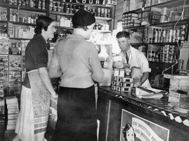 City of Kingston
Photograph - Black and white, c.1930
This photograph shows Judd's Grocery Shop located at 224 Charman Road, Cheltenham in the 1930's. Alan Hutchins is the shop attendant, serving two patrons; Merle Judd (left) and Marion Elliott (right). Judd's Grocery Shop was opened by Clarence Judd in the 1920's and was a successor to the family's business formerly located on the corner of Centre and East Boundary Roads, East Bentleigh. Cheltenham had become an established village during the 1920's and Charman Road represented a second, more commercial development in the area. Black and white photograph of a grocery shop interior displaying a variety of items for sale. A male stands behind a counter, looking at the camera. Two females stand in front of the counter facing the male. One female is wearing a hat. Handwritten in blue ink: 181 Handwritten in red ink: 72%shopping, strip shopping, cheltenham, charman rd, grocery -
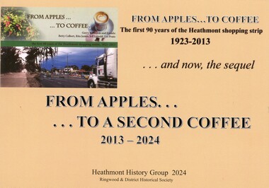 Ringwood and District Historical Society
Book - Heathmont Shopping Strip, From Apples to a Second Coffee 2013-2024
Soft covered wire bound book. Sequel to earlier book titled The First 90 years of Heathmont Shopping Centre 1923-2013.Contents: Area 1 - West side odd numbers - 95 Canterbury Road down to trainline Area 2 - West side odd numbers - from trainline up to 165 Canterbury Road Area 3 - East side even numbers - from Allens Road down to laneway Area 4 - East side even numbers - from laneway down to trainline What cannot be purchased in Heathmont in 2024 Strip Series: annual changes 2014 to 2024 Covid pandemic 2019-2020 Future directions Current HHG and Heathmont publications list. Acknowledgements: Heathmont History Group members - Laurie Allen, David Gee, Gerry Robinson, Ray Stevens, Trevor Weir. Sketches by David Williams (dec.). Ringwood & District Historical Society. -
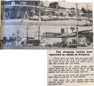 Greensborough Historical Society
Newspaper - Newspaper Clipping - Digital Image, Few shopping centres have expanded as rapidly as Watsonia
This article shows two views of Watsonia shopping strip on Watsonia Road, taken from Morwell Avenue, indicating the expansion over twenty years.Digital copy of newspaper articlewatsonia shopping centre, watsonia road watsonia, morwell avenue watsonia -
 Sunbury Family History and Heritage Society Inc.
Photograph, The Royal Hotel, C1939
The two storey building is the Royal Hotel which replaced an earlier single storey building that was destroyed by fire in 1935. It stood on a corner at the intersection of Brook and Evans Street. The new hotel was completed and opened in 1939 on the same site and still functions as a hotel today. The Royal Hotel was has occupied the same site in Sunbury's shopping strip for 163 years.A non-digital black and white photograph with a cream border of a brick two storey hotel with white trims around the windows and doors. The building occupies a street corner in a shopping centre.hotels, brook street, evans street, royal hotel -
 Eltham District Historical Society Inc
Photograph, Beard Street and Main Road Eltham, 20 Jan 1986, 20/01/1986
During the recent refurbishment of our Local History Centre we came across a roll of 35mm colour negatives which at some stage had been exposed to water or similar resulting in the individual strips sticking to each other and the old paper film processing envelope. The situation looked hopeless but one of our members had an idea on how to salvage them; after all, we had nothing to lose. In the end we were able to separate the film strips and remove most of the paper residue except some of the adhesive. The film was scanned and even though suffering from various light issues; fading, possible exposure problems and a yellow shadow cast by the adhesive residue, the detail and historical information they contain has been rescued. These images are all centred around the intersection of Beard Street and Main Road Eltham. The Sun headline is "Poison Dumped in Murray" which has been dated to 20 Jan 1986 1986 'Poison in Murray cuts town water', The Canberra Times (ACT : 1926 - 1995), 20 January, p. 1. , viewed 30 Aug 2017, http://nla.gov.au/nla.news-article122421767A favourite milk bar of the time for local youth as evidenced from comments on the ThrowbackThursday Facebook Page post. Frame 01791-1 shows the auction sign for the land on the southeast corner of Main Road and Beard Street which was developed into a small group of shopsRoll of 35mm colour negative film, 4 stripsKodak CL 200 5093eltham, main road, beard street, eltham east service centre, bp service station -
 Eltham District Historical Society Inc
Photograph, Beard Street and Main Road Eltham, 20 Jan 1986, 20/01/1986
During the recent refurbishment of our Local History Centre we came across a roll of 35mm colour negatives which at some stage had been exposed to water or similar resulting in the individual strips sticking to each other and the old paper film processing envelope. The situation looked hopeless but one of our members had an idea on how to salvage them; after all, we had nothing to lose. In the end we were able to separate the film strips and remove most of the paper residue except some of the adhesive. The film was scanned and even though suffering from various light issues; fading, possible exposure problems and a yellow shadow cast by the adhesive residue, the detail and historical information they contain has been rescued. These images are all centred around the intersection of Beard Street and Main Road Eltham. The Sun headline is "Poison Dumped in Murray" which has been dated to 20 Jan 1986 1986 'Poison in Murray cuts town water', The Canberra Times (ACT : 1926 - 1995), 20 January, p. 1. , viewed 30 Aug 2017, http://nla.gov.au/nla.news-article122421767A favourite milk bar of the time for local youth as evidenced from comments on the ThrowbackThursday Facebook Page post. Frame 01791-1 shows the auction sign for the land on the southeast corner of Main Road and Beard Street which was developed into a small group of shopsRoll of 35mm colour negative film, 4 stripsKodak CL 200 5093eltham, main road, beard street, eltham east service centre, bp service station