Showing 39 items
matching surveyors level
-
 Stratford and District Historical Society
Theodolite
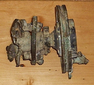
This theodolite was used by `Mr Dawson' (presumably William Tennant Dawson c.1820-1873) who `surveyed much of the area around and beyond Stratford'. It was damaged by the fire which burnt the original Roseneath home in 1921, when the Macleods were in residence. (Mrs W.T. Dawson was a Macleod). One little boy aged 3 years was given the job of saving everything on the kitchen table when the fire started at breakfast time. The theodolite was possibly in use by Dawson when he laid out St Kilda Road.This theodoite consists of a bottom plate, which is damaged and has melted metal. This rises to a ball joint, on which is pivoted another plate on which were housed four screws, of which three remain, to adjust the level. Above this is another plate, with compass markings and melted glass."Troughton and Simm's/London" in fine engraving on upper plate.surveyors, instruments -
 Koorie Heritage Trust
Book, Bonwick, James, Port Phillip settlement, 1883
Contents: Discovery; Mr. Grimes round the Bay, 1803; Settlement of 1803; The settlement of 1826; Hume and Hovell's overland journey; The Western Port settlement; Captain Sturt on the Murray; Portland Bay settlement in 1834; Major Mitchell's discoveries in Australia Felix; Life of John Batman; Batman's journal and report; The wild white man; The surveyor's note-book and report; Life of Mr. Fawkner before 1835; Fawkner on the Yarra Yarra; Official correspondence; The Port Phillip Association; Official recognition of trespassers; First Government of Port Phillip; Mr Gellibrand lost in the bush; The Governor's visit to the Yarra; Melbourne and its land sale; The stock question; Mr Mackillop's narrative; Progress of the settlement; The early Melbourne press; Discovery of Gipps Land; The Black Question; Narratives of Old Hands; Causes of emigration in 1835; An Overland journeyx, 537 pages, [36] leaves of plates (some folded.) illustrations (1 colour), facsimiles, portraits ; 23 cm.Contents: Discovery; Mr. Grimes round the Bay, 1803; Settlement of 1803; The settlement of 1826; Hume and Hovell's overland journey; The Western Port settlement; Captain Sturt on the Murray; Portland Bay settlement in 1834; Major Mitchell's discoveries in Australia Felix; Life of John Batman; Batman's journal and report; The wild white man; The surveyor's note-book and report; Life of Mr. Fawkner before 1835; Fawkner on the Yarra Yarra; Official correspondence; The Port Phillip Association; Official recognition of trespassers; First Government of Port Phillip; Mr Gellibrand lost in the bush; The Governor's visit to the Yarra; Melbourne and its land sale; The stock question; Mr Mackillop's narrative; Progress of the settlement; The early Melbourne press; Discovery of Gipps Land; The Black Question; Narratives of Old Hands; Causes of emigration in 1835; An Overland journeymelbourne (vic.) -- history -- to 1834. | melbourne (vic.) -- history -- 1834-1851. | port phillip bay region (vic.) -- history. -
 Bendigo Military Museum
Photograph - Royal Australian Survey Corps Surveyors in the Field – North Queensland, 1958
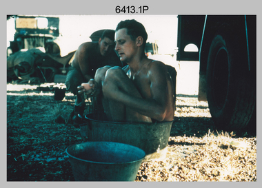
This is a set of seven photographs of surveyors and support staff in the field undertaking duties in North Queensland in 1958. The surveyors were employed in the establishment of mapping and geodetic control. In this era surveyors used theodolites to observe horizontal and vertical angles and chains to measure base line distances between survey stations. Bob Skitch shown in photos .4P to .6P was in the 2nd year of his career in the Australian Army. He achieved the rank of Lieutenant Colonel and his last appointment was the CO of the Army Survey Regiment from 1976 to 1980. The annotation on the back of photo .5P ‘Black foreground is where Bob Skitch boiled billy and started a grass fire’.This is a set of seven photographs of surveyors and support staff in the field undertaking duties in North Queensland in 1958. The photographs were printed on photographic paper and are part of the Army Survey Regiment’s Collection. The photographs were scanned at 300 dpi. .1) - Photo, colour, 1958. Surveyor in Nth QLD enjoying a bath. L to R: Don Cocker, Bob Thompson. .2) - Photo, colour, 1958. Don Cocker surveyor in Nth QLD, enjoying a bath. .3) - Photo, colour, 1958. Surveyors Nth QLD undertaking survey observations, using MRA1 tellurometer to measure base-line distances. L to R: Len Davies, Lou Sommer, John Van De Graff. MRA1 was covered to stop overheating. .4) - Photo, colour, 1958. Surveyors south of Richmond, QLD digging holes for the erection of a Bilby observation tower. L to R: John Van De Graff, Bob Skitch, Kev Moody, Mal Hayes, Don Gray .5) - Photo, colour, 1958. Surveyors south of Richmond, QLD erecting a Bilby observation tower. L to R: Tom Royle, Bob Skitch (on ground level), Mal Hayes. .6) - Photo, colour, 1958. Surveyors south of Richmond, QLD erecting a Bilby observation tower. L to R: Tom Royle, Bob Skitch, Mal Hayes, Jim McGill (on ground level). .7) - Photo, colour, 1958. Surveyors south of Richmond, QLD undertaking survey measurements from a Bilby observation tower..1P to .7P annotated on back – personnel names, the year and the location. Annotated on back of .5P ‘Black foreground is where Bob Skitch boiled billy and started a grass fire’.royal australian survey corps, rasvy, army survey regiment, asr, army svy regt, fortuna, surveying -
 Melbourne Tram Museum
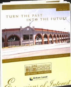
Document - Folder with papers, Urban Land corporation, "Hawthorn Tram Depot - Expressions of Interest Documentation", late 1998
White two spring clip folder with papers, titled "Hawthorn Tram Depot - Expressions of Interest Documentation", sub-titled "Turn the Past into the Future" Has a photo of Hawthorn Tram depot and an image on the front cover. Closing date 17/2/1999, prepared by the Urban Land Corporation with the assistance of VicTrack. Approx 110 pages with supplementary papers in the end covers. Contains a table of contents, checklist, EOI Process, Development Brief, Site conditions. Gives details of the heritage registration, site plans, building plans, property title and detailed room condition and use of the ground floor. Supplementary papers include the marketing brochure, letters and a detail feature and level survey by Bosco Johnson surveyors, 30-9-1998.trams, tramways, htt, hawthorn tram depot, sale of land, property -
 Ringwood and District Historical Society
Map - Plans of Subdivision, Part of Crown Allotments 35 & 39, Parish of Warrandyte
Survey maps of stages 1, 2 & 3 of residential allotments in Kalinda Road and Grayling Crescent, Ringwood, Victoria. (Undated, circa 1960). Some allotments are marked with real estate information and prices in pre decimal £s.Adshead & McGuire, Land Surveyors L.S. M.I.S. (Aust), 268 Albert Street East Melbourne (Ref 118/2a b &c) Tel 41-6960. The land colored blue is set apart for drainage & sewerage purposes. Reference Marks (R.M's) are Gal Iron Pipes 12"x1". Levels shown are to M.M.B.W. Datum. The land shown hatched is subject to innundation. -
 Bendigo Historical Society Inc.
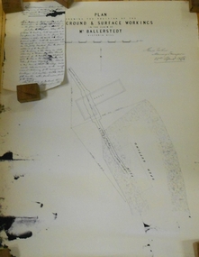
Document - MARKS COLLECTION: PLAN RELATING TO UNDERGROUND AND SURFACE WORKINGS VICTORIA HILL
Plan on paper: on top of plan 'plan showing the position of the underground & surface workings in the claim of Mr. Ballerstedt Victoria Hill' Signed by Thomas Forbes, Mining Surveyor, 22nd. April 1868' Attached to plan is a letter report accompanying plans on the underground workings in (illegible) Ballerstedt & Sons, Victoria Hill (ink blot covering writing RH side) Text of letter begins : the underground level southwards from the shaft is 4ft 6' x 6 ft wide as shown on the plan; and is at a depth of (illegible) from the surface; along the (illegible) of which the timbering both upright and cap-pieces; are now in as good condition as when the work was being proceed with; with the exception of the uprights and one cap-piece which are slightly crushed from the general settlement of the mullock. The timbering of the drives is still standing in the same position though upwards of 12 months has elapsed after the slip in the open cutting had taken place, showing very clearly in my mind that the slip could not be attributable to the insufficient timbering of the underground workings; but rather to the action of the weather in this particular part of the cutting. The probably quantity of mullock that was detached or slipped from the west side of the cutting; would be (from careful enquiry and observation ) about 1500 loads at least; enough to crush the whole of the timber in the levels, if it had not been of the most substantial character and I think yours to prove that the fall was not caused by any defective timbering but from the cause already stated. I may state that I have inspected the underground workings generally in the mine, and the timbering is of the most substantial characterbendigo, mining, victoria hill -
 Bendigo Military Museum
Journal - Desert Exploration - Extract from Northern Territory Lands and Survey Dept Annual Report 1960-61, Northern Territory Lands and Survey Branch, 1961
This Extract from Northern Territory Lands and Survey Dept Annual Report 1960-61 is about Desert Exploration between Wave Hill and Tennant Creek. The 2 x fold out maps are 1:1,000,000 scale with one showing a Levelling Traverse. The exploration took place during March and April 1960. This document has been included in the RASvy collection because it was valuable information that was needed by RASvy surveyors who were required to operate in the area in later years.5 x foolscap sized pages and 2 x map foldout pages held together with a slide clip. Pages and maps are two hole punchedroyal australian survey corps, rasvy, fortuna, army survey regiment, army svy regt, asr -
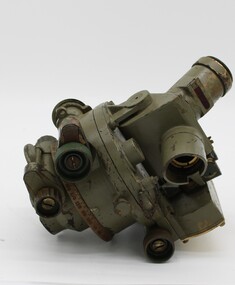 National Vietnam Veterans Museum (NVVM)
Equipment - Dumpy level in case
... in WW2. surveying tool dumpy level survey surveyor level place ...Standard equipment as used by Australian servicemen during the Vietnam conflict. This type of level was first issued for use in WW2.Khaki metal instrument with lens-viewfinder and numbers on circular range finding wheels. Object is stored in a khaki metal box with canvas carry straps. Attachments inside the box prevent it from slipping. Red label attached to strap says the object cannot be repaired.place/date/McBc = GdBg/ McB6 = GdBg/ BuBl COR. Inside box: scientific instruments MFGI and Repair Co. Pty Ltd/ 573 Burwood Road, Hawthorn 815527surveying tool, dumpy level, survey, surveyor, level -
 Ringwood and District Historical Society
Document - Plan of Subdivision, Part of Crown Allotment 31B, Parish of Warrandyte - 1965
Map showing residential allotments numbered 1, 2, 4 and 5, on Through Road, Ringwood, Vic., with property dimensions, including weatherboard house and galvanised iron garage on lot 2.Kirkpatrick & Webber, Licensed Surveyors, Civil Engineers & Town Planners, Maroondah Highway, Ringwood, Telephone 8700321. Ref 3438C. Date 4th December, 1964. Amended 19th July, 1965. Notation: "The land coloured blue is a drainage and sewerage easement. Levels are to Board of Works Datum. Lot number 3 has been omitted."